Showing posts with label Mare material. Show all posts

Thursday, June 5, 2014

Rima Seuss, rough around the edges

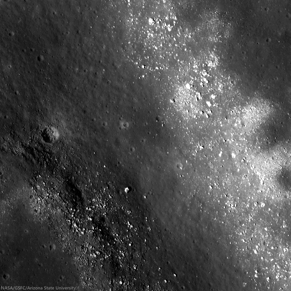
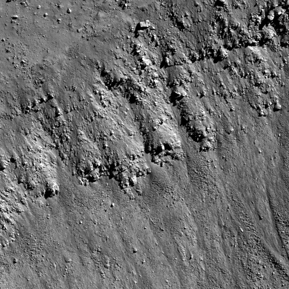
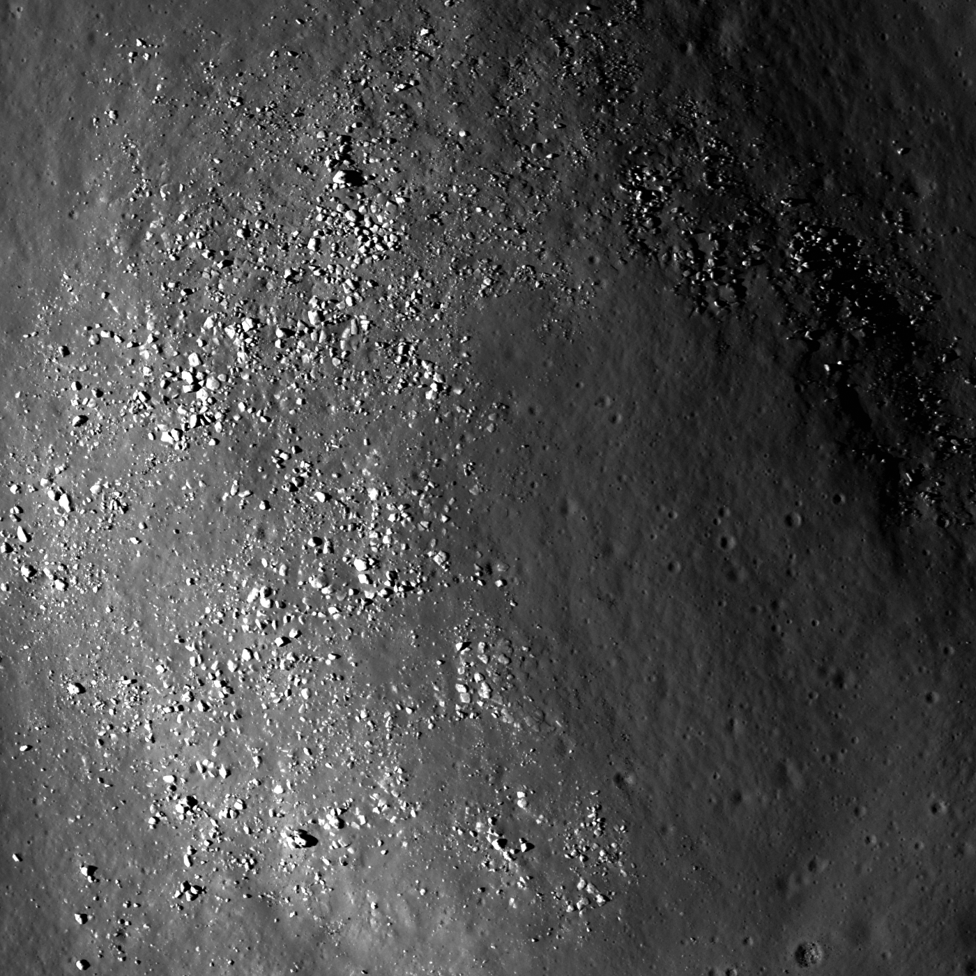
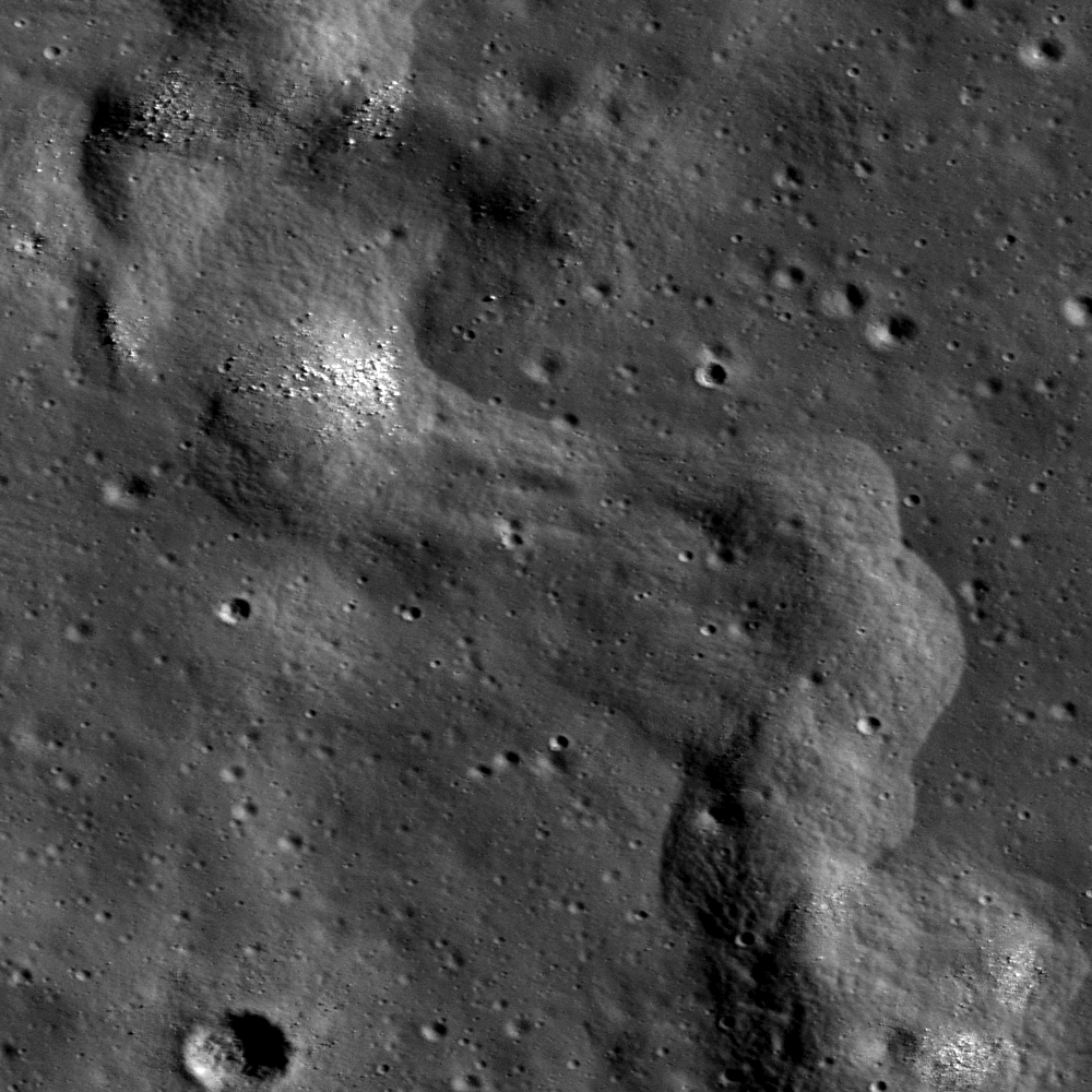
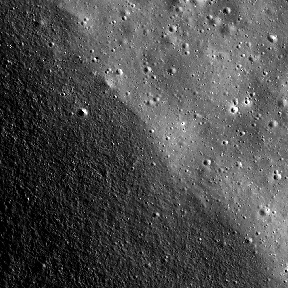
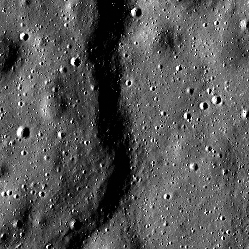
With peppered flanks, Rima Suess wanders over 150 km through Oceanus Procellarum. The rocks that rest on the walls of this sinuous rille are perhaps remnants of much larger boulders that have eroded down to meter sized rocks due to relentless micro and macro meteorite bombardment, "gardening" 3 centimeters into lunar dust every 2 million years or so. The pyroclastic flow that carved through the terrain was remarkably fast, considering the long scar left behind has lasted perhaps 3 billion years. From the extraordinary low altitude of only 23 km (see below), the 400 meter field of view above is cropped from LROC NAC observation M168516400R  [NASA/GSFC/Arizona State University].
Raquel Nuno
LROC News System

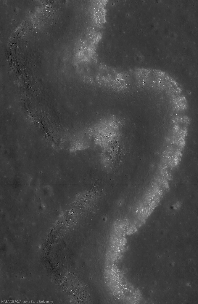
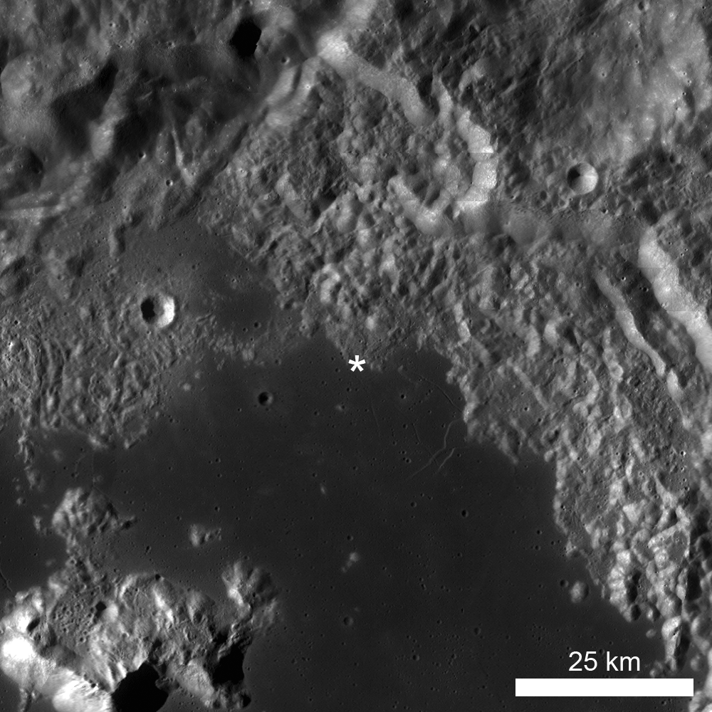
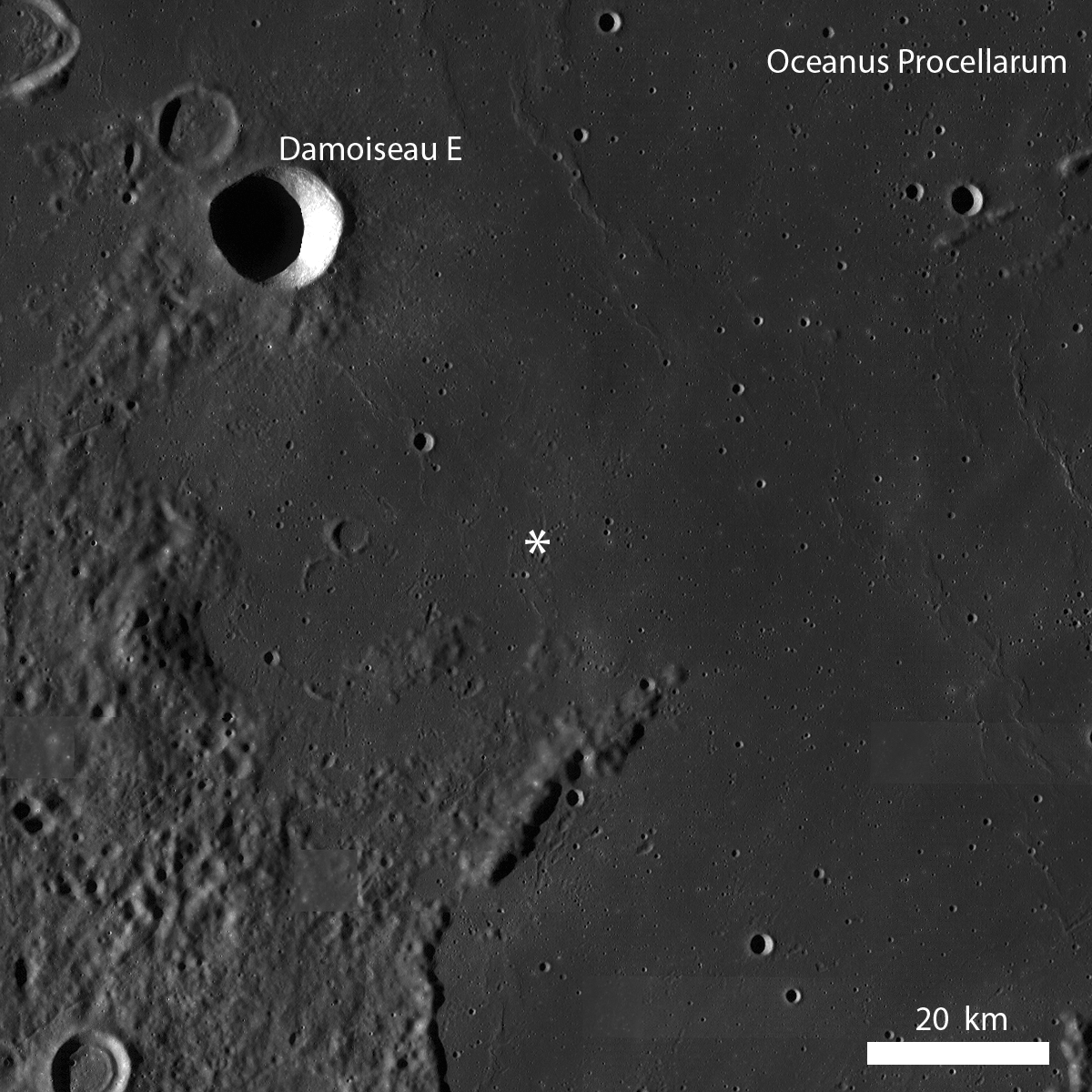
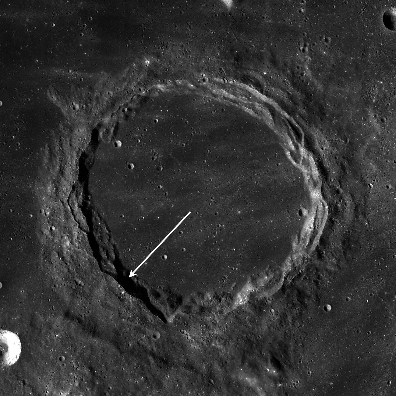
Rima Suess (7.81°N, 312.41°E), located in Oceanus Procellarum, is a long, meandering narrow depression called a sinuous rille.

Sinuous rilles, most commonly found in mare surfaces, are thought to have been carved by fast rivers of lava, which thermally and mechanically eroded the channels we see today.

About 3.1 billion years ago the Moon was much more volcanically active, pouring vast amounts of lava onto the surface. The large dark mare regions of the Moon were formed by massive eruptions of iron-rich basaltic lava during this time.

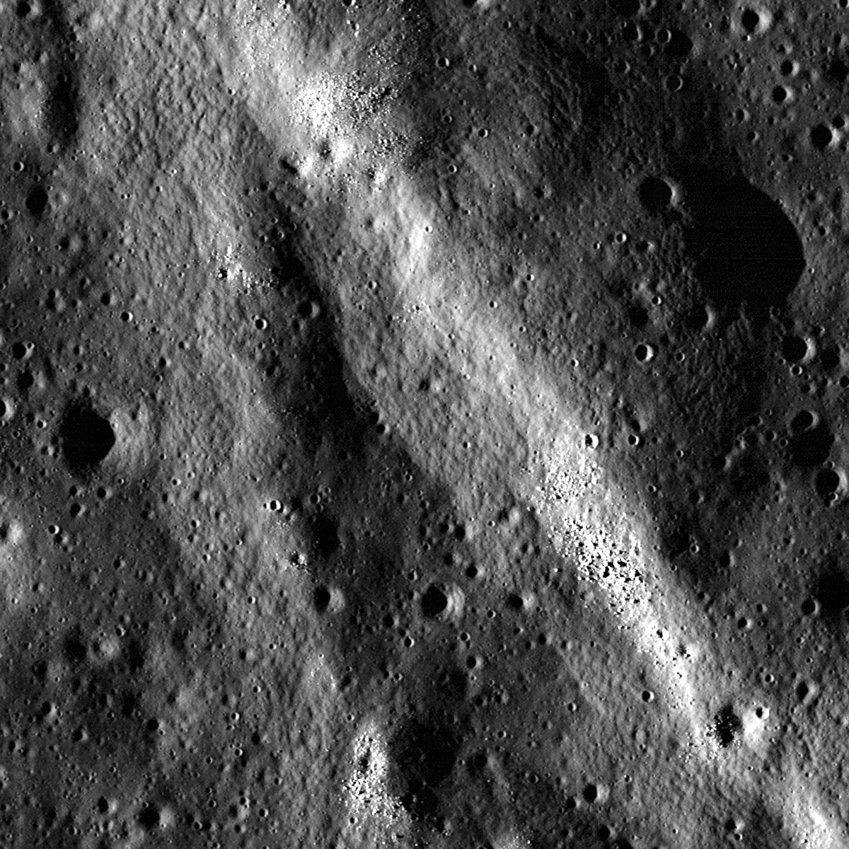
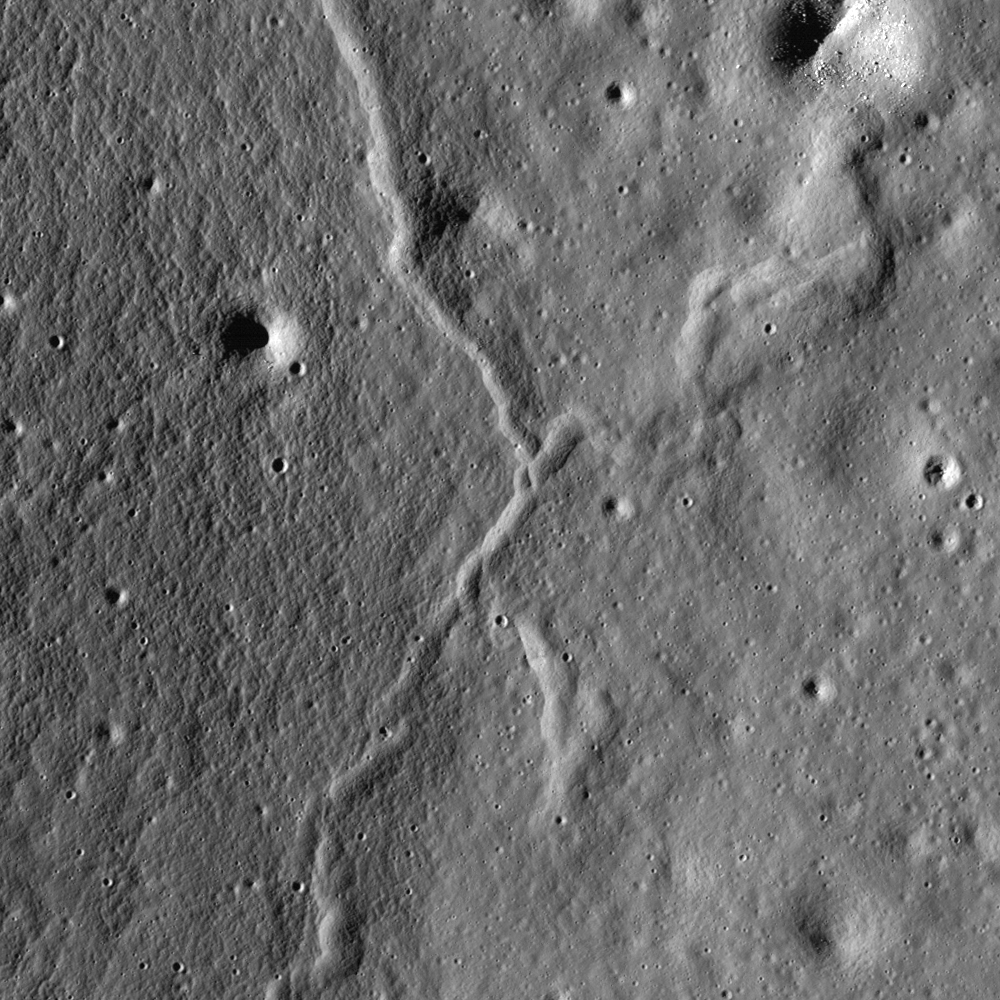
Very close-up on Rima Suess, the LROC NAC observation from which this and the LROC Featured Image were processed was from among one of the closest passes of the Lunar Reconnaissance Orbiter (LRO) over the Moon, during low-periapsis maneuvers in 2011. (Full resolution original image HERE.)  LROC NAC observation M168516400R, LRO orbit 9968, August 12, 2011; 36.11° incidence angle, resolution 39 cm from 22.92 km over 8.07°N, 312.38° [NASA/GSFC/Arizona State University].
The boulders along the walls of the rille probably were a coherent mass when the lava flows cooled, breaking up over billions of years of impacts into the boulders we see today. Gravity then pulled this material down the slope of the rille; this process is known as mass wasting. We see rock outcrops over the entire path of Rima Suess in the LROC NAC image M168516400R.

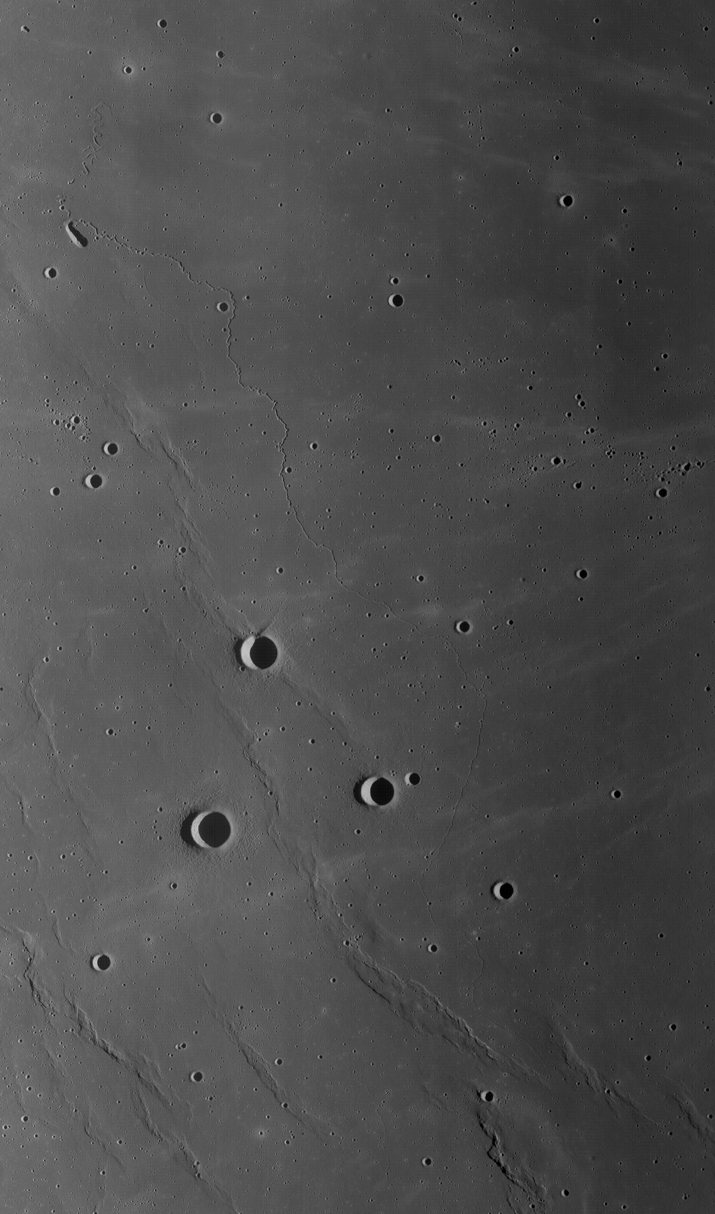
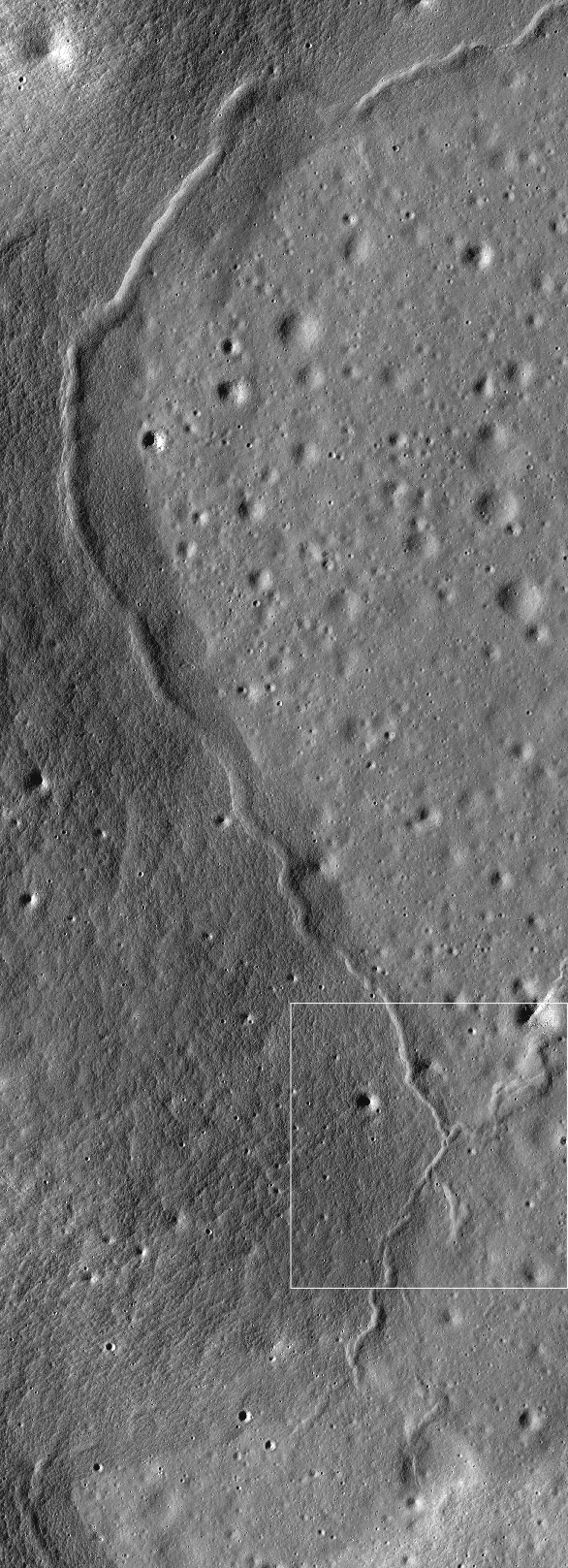
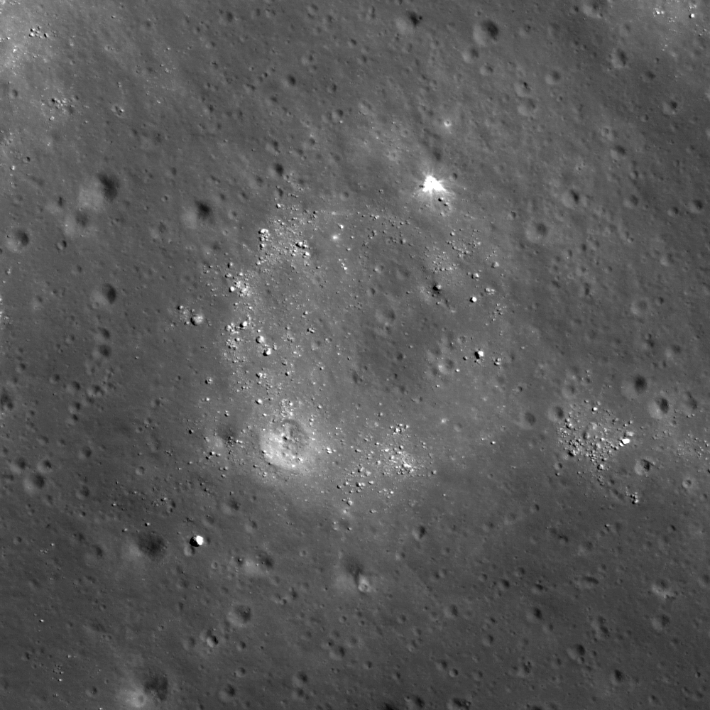
The very narrow, actually a 200 km-plus-long sinuous rille, apparently traced remarkably fast south from the Marius Hills "Yulu" double-volcano source nearly to Flamsteed P crater, through the bleak center of Oceanus Procellarum. Nearby Kepler crater (outside this view, to the right and east) added the bright ejecta rays. This view is distilled from a mosaic of LROC Wide Angle Camera (WAC) observations swept up over five sequential orbits during local early local morning, allowing long shadows to add some relief to this remarkably flat area of the lunar surface, all of it averaging below 2000 meters in elevation. LROC WAC mosaic from LRO orbits 6838 through 6842, December 18, 2010; 79° incidence angle, resolution 58 meters from 41.5 km [NASA/GSFC/Arizona State University].
Lunar rilles are exciting places for lunar scientists because they may cut through and expose the different layers of lava flows in the maria.  This gives scientists insight into the volcanic processes present during mare formation, and how they evolved with time.

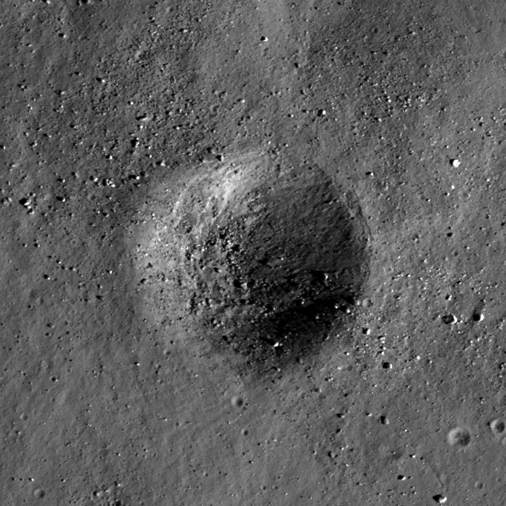
Explore the winding path of this portion of Rima Seuss in the full resolution LROC NAC HERE.

Related Posts:
Rilles as far as the eye can see in Prinz!
Rille within a rille!
Collapsing Tube

Thursday, November 15, 2012

Layers of Imbrium floor excavated at Piton B

Southern contact of Piton B crater wall and rim. From LROC Narrow Angle Camera (NAC) observation M168203756R, orbit 9922, August 17, 2011; 290 meter-wide field of view captured from a mere 28.75 kilometers, resolution 42 centimeters per pixel, centered near 39.292°N, 359.883°E. North is up [NASA/GSFC/Arizona State University].
Hiroyuki Sato
LROC News System

Piton B is a young, fresh crater (about 4.5 km diameter) located in northeast Mare Imbrium. Along the upper part of this young crater wall, you can find clear layering similar as seen in Meteor Crater at east of Flagstaff, Arizona. The opening image highlights such layerings observed at the southern crater wall of Piton B.

In the lower right corner of this image is a portion of the crater rim, downslope is toward the top. The relatively resistant layers discontinuously outline their horizontal expanses. Among them, the blocky outcrop at the center of this image shows the clearest bedding plane. 

The thinnest layers are roughly 3 to 4 meters thick, assuming a slope angle about 30°.

Context for the Featured Image field of view (white rectangle) in the full width of the left and right frame of LROC NAC observation M168203756 [NASA/GSFC/Arizona State University].
Layer thickness estimates from orbital views are not as accurate as geologists would make standing on the outcrop, but many measurements at multiple craters give a great estimate of the general layer thicknesses of the original lava flows. Knowing thickness of flows helps us understand the viscosity and flow rates of ancient mare volcanism.

Piton B (below center) in LROC Wide Angle Camera 100 meter resolution mosaic on LOLA laser altimetry based topography from a simulated perspective 14 km over the vast Imbrium floor. Beyond are Piton A and their namesake Piton Mons [NASA/GSFC/Arizona State University].
Explore the fresh crater wall of Piton B in full NAC frame yourself, HERE.

Related Posts:

Thursday, August 2, 2012

LROC: Sinuous Ridges on the Slope

Triple junctions of wrinkle ridges at the western edge of Bolyai crater floor. Image field of view is 1270 meters, LROC Narrow Angle Camera (NAC) observation M134368363L, LRO orbit 4935, July 21, 2010; incidence angle 72.2° at 1.27 meters resolution from 61.04 kilometers. Sunlight is from the west. View the larger (~80%) original LROC Featured Image HERE [NASA/GSFC/Arizona State University].
Hiroyuki Sato
LROC News System

Today's Featured Image involves sinuous ridges observed at the western edge of the mare basalt deposit on the floor of Bolyai crater. Bolyai is a ~100 km diameter crater located at 33.85°S, 126.12°E, about 400 km south of Tsiolkovskiy crater. The northern part of the crater floor is filled by a mare basalt deposit (see WAC context image at the bottom of this post). Notice that the sunlight is from the left side of the image, thus the circular features (craters) are negative relief and sinuous line-features are positive relief.

The ridges show bifurcations at the middle of the image, and two ridge branches extending toward the northeast and southeast of this image gradually become less apparent. The southwestern branch strongly meanders and eventually disappears as well. On the other hand, the northwestern branch extends on the crater slopes all the way along the western boundary of the mare deposit (see the NAC context image below), about 80 to 300 m away from this "shoreline". How did all these ridge systems form? Could they really be "splash marks" like in Tuesday's post, or are they something else?

Western edge of mare basalt deposits, traced by wrinkle ridges on the slopes of Bolyai crater wall. A section of the width of LROC NAC frame M134368363L is layered on the Google Earth lunar digital terrain model. Section field of view is approximately 2.4 km across, and the area in the Featured Image is outlined by the white box [NASA/GSFC/JAXA/USGS/ASU].
In many cases, splash marks include boulders that were deposited at the "wave front" of the melt, which is not the case in today's image. The wrinkle ridges, a compressional deformation feature caused by thrust faults, can crosscut each other, which would explain the bifurcation of the ridges in the top image. But then, did the whole western part of the lava pond slip, forming the surrounding wrinkle ridges? Obviously, a series of complicated geologic events happened in this particular mare deposit within Bolyai.

Northern part of Bolyai crater, once again in Google Moon, and as the scene might be viewed from 47 km over a point southeast of the area of interest. LROC Wide Angle Camera (WAC) monochrome (604nm) mosaic stitched from observations gathered during 9 sequential orbital opportunities averaging 46.8 km, and at 62 meters resolution, November 25, 2011. The locations of the full NAC frame M134368363L is outlined by the blue rectangle and the yellow arrow marks the approximate location of the field of view highlighted in the LROC Featured Image released August 2, 2012 [NASA/GSFC/Arizona State University].

Explore this set of sinuous ridges full LROC NAC frame for yourself, HERE.

Related Posts:
Constellation Region of Interest at Mare Tranquillitatis
Wrinkle ridge in Oceanus Procellarum
Stress and pull
Tectonics in Mare Frigoris
Bulging Wrinkle

Wednesday, April 11, 2012

LROC: Flow Boundary in Mare Imbrium

A small scarp is exposed in this high sunrise incidence angle (75.95°) Narrow Angle Camera frame, around 95 kilometers north by northeast of Mons La Hire in Mare Imbrium. The area to the east is raised relative to the area on the west of the scarp by as little as 10 meters. LROC NAC M177792062L, LRO orbit 11337, December 6, 2011; field of view 610 meters, resolution 0.6 meters per pixel from 43.86 kilometers. View the full-size LROC Featured Image HERE [NASA/GSFC/Arizona State University].
Drew Enns
LROC News System


Today's Featured Image shows the boundary of a flow front in Mare Imbrium. Unlike other flows LROC has observed (granular, impact melt), these are lava flows! The flows are about 35 m thick, making them hard to observe unless the Sun is low and casting long shadows.

Apollo 15 imaged the flows early in the lunar morning, when the Sun was low on the horizon to help the low relief flows cast larger shadows!

Combining the observed geometric properties of these flows with viscosities calculated from the Apollo samples allow scientists to constrain how lava behaves on the Moon.

The same field of view at a slightly less inclined morning incidence angle (60.84°), LROC NAC M129452673R, orbit 4211, May 25, 2010, resolution 0.46 meters from 37.66 kilometers [NASA/GSFC/Arizona State University].
For context, the full, uncorrected approximate 2200 meter width of the field of view swept up in LROC NAC M129452673R. The area of interest is just left of center [NASA/GSFC/Arizona State University].
LROC Wide Angle Camera (WAC) context for the LROC Featured Image, released April 11, 2012 and narrowly focused near 30.593° N, 335.302° E. The WAC observation above was swept up from the orbiter during the same orbital pass as that of the Featured Image NAC frame. The large incidence angle brings out subtle changes in topography, enhancing the Imbrium lava flows. Image field of view is 35 kilometers. LROC WAC M177791761C (604nm), resolution 60 meters per pixel [NASA/GSFC/Arizona State University].
The Imbrium flows are fairly thick, and the WAC context shows them extending for at least 120 km, but the flows continue for several hundred kilometers. Should we expect this? Because the Moon's gravity is weaker than the Earth's, we can expect lunar lava flows to be ~1.7 times as thick as a terrestrial flow of similar length! 

Flows of similar length on Earth have only been observed in flood basalts, which are large volumes of lava that were erupted quickly. 

This correlation indicates that the lunar lava flows must have erupted quickly as well. Even so, these flows are some of the few examples still visible on the Moon's surface, and it is unclear how their thickness and extent relate to the majority of volcanism that filled in the large basins resulting in the maria.

Check out more lava related feature posts below and explore the lava flows in the full LROC NAC Featured Image, HERE.

Related Posts:
Layers near Apollo 15 landing site
Layering in Euler Crater
Old Man River of Lava

Wednesday, January 25, 2012

LROC: Brayley G

This small (around 140 meters across) crater is perched on the edge of something much more extraordinary. LROC Narrow Angle Camera (NAC) frame M175515801L, November 9, 2011 30 cm pixel scale, field of view 300 meters across. View the full size LROC Featured Image HERE [NASA/GSFC/Arizona State University].
Sarah Braden
LROC News System

The impact crater in today's Featured Image rests on the edge of another crater known as Brayley G, however this crater is most likely volcanic! Brayley G is a beautiful volcanic vent located in the mare at 24.2°N, -36.4°E. In 2008, before LROC launched, we wrote about Brayley G in the Apollo Image Archive Featured Image.

Today we are proud to present a LROC NAC mosaic of the 3 km wide and less than 5 km long feature. Compare the new LROC NAC observation to images from Apollo 15 and 17 in the graphic below (or visit the Apollo Image Archive). Note how the differences in incidence angle highlight different features within Brayley G. The higher-incidence Apollo images highlight the morphology of the edges of the vent and the concentric faults. The lower-incidence LROC NAC image reveals the interior of Brayley G, which contains many boulders along the inside wall and more collapse features.

The same small crater (white arrow) in the context of the ancient Brayley G vent, from the full field of view seen in the LROC NAC mosaic released January 24, 2011. Below, a side by side comparison (original HERE) of Apollo 15 and Apollo 17 orbital mapping camera images. Because of LRO, it's now possible to see the interior of this volcanic feature [NASA/JSC/GSFC/Arizona State University].

So how do scientists tell the difference between a volcanic vent and an impact crater? Most lunar craters are bowl-shaped and circular depressions with raised rims. When an impact occurs it excavates material from below the surface and ballistically ejects that material outward from the point of impact. This process leaves a visible ejecta blanket around the crater rim. Over time, erosion and slumping of crater walls can degrade and eventually remove an elevated crater rim. Studying examples of small, recent impacts shows the link between these physical processes and the surface features they leave behind. Volcanic vents, on the other hand, are usually not circular and they do not have raised rims. While volcanic vents do not have impact ejecta blankets, they can be surrounded by a "halo" of pyroclastic material from a past eruption.

Above: Closer isn't necessarily 'better,' ascetically speaking.  From barely 27 kilometers above, and under a bright local mid-afternoon Sun (incidence 45.41°), LROC Wide Angle Camera (WAC) observation M168441281C (604 nm) from orbit 9958, August 20, 2011; raw resolution 43.4 meters per pixel. Below, from 45.8 kilometers (and superior alignment of the image 'framelets') and under a lower local morning Sun (incidence 55.64°), LROC WAC observation M144863532C (643 nm); context image of the Oceanus Procellarum mare surrounding the 3 kilometer across Brayley G vent. The white arrow again marks the location of the small crater on the edge of Brayley G. Resolution 64 meters per pixel. [NASA/GSFC/Arizona State University].

Brayley G is most likely a volcanic vent since it is has no elevated rim, is oblong in shape (not circular), and has no ejecta blanket. There are also concentric lines on the inside edge of Brayley G, which may be evidence of concentric faults, left by the partial collapse of the vent. Some depressions may also be formed by the collapse of a sublunarean cavity, such as an drained lava tube.

Explore the entire NAC mosaic, HERE.

Related Posts:

Thursday, September 29, 2011

LROC: Highland-Mare Boundary of Tsiolkovskiy


Central segment from HDTV still returned by Japan's lunar orbiter Kaguya (SELENE-1, 2007. This oblique, long-range view across the craggy expansive floor and central peak from the north shows Tsiolkovsky crater's floor. It's prominent on the farside because such dark features are far fewer here than on the Nearside. The slumped inner circumference of Tsiolkovsky's rim glowers several kilometers over its floor, an area where the Naval Research Lab, MIT and NASA hope one day to eventually deploy a radio array shielded from man-made interference. Such a facility could probe the cosmological "Dark Ages," a poorly understood 200 million year-long time between the Big Bang and the formation of earliest stars and galaxies.

LROC used it's Narrow Angle Camera (NAC) to study the contact boundary between rugged highland and Tsiolkovsky's relatively flat and darker floor. (The area shown in a Featured Image released September 28, 2011 is indicated by the yellow arrow) [JAXA/NHK/SELENE].


The mare plain of Tsiolkovsky stood out plainly in the first images of the lunar Farside returned by the Soviet probe Luna 3 in 1959, highlighting from the start the striking differences between the familiar features of the Moon's nearside and an entire hemisphere never before seen by human eyes. The northeastern contact area highlighted below in a more detailed look at this part of the LROC WAC 100 meter resolution Global Mosaic is boxed in yellow [NASA/GSFC/Arizona State University].


Northeastern portion of Tsiolkovsky crater, highlighting the boundary between mare and the highlands. Asterisk notes location of NAC inset; LROC WAC monochrome mosaic, 100 m/pixel. View the full-size LROC image released September 28, 2011 HERE [NASA/GSFC/Arizona State University].

Lillian Ostrach
LROC News System

Tsiolkovsky crater is a stunning example of a complex crater and is located on the farside (185 km diameter; 20.46°S, 129.06°E). Many geological features are observed within and around this impact crater, including a central peak, terraced walls, extensive ejecta, and a partially mare-filled floor. Tsiolkovskiy is an experiment in mare basalt flooding that is frozen in time and contains one of only a few mare deposits on the lunar farside. When we usually think of mare basalts, we mentally picture the vast nearside basalts, probably because we see them so clearly during a full Moon. These nearside basalts fill (or just nearly fill) the large impact basins that formed early in the Moon's geologic history, but the basalts that flooded Tsiolkovsky (as well as those that formed Mare Moscoviense and Mare Orientale, for example) only partially flooded these farside basins. Thus, we can use these basins to study the geology of the farside mare deposits and the timing and extent of volcanism on the lunar farside.

Because substantial lateral mixing of materials on the Moon is limited, the boundary between the mare and the highlands within Tsiolkovskiy crater is particularly obvious. In the opening image, the high-reflectance highlands material in which Tsiolkovskiy formed is embayed by the lower-reflectance mare basalt. The area of the crater floor flooded by basalt is smooth and has low reflectance while the central peak, crater walls, and portions of the floor remain relatively unchanged except for the accumulation of small impacts (meters to ~5 km diameter) over geologic time.


Full 60 centimeter per pixel resolution close-up of LROC Narrow Angle Camera (NAC) observation M159100547R. LRO orbit 8580, May 3, 2011, showing a small part of the the boundary between mare and highland material in Tsiolkovsky. Instead of an obvious contact boundary between these units the change from highland to mare is gradational at this scale. The degraded crater at center has served as a slope trap for high-reflectance material that originated from the high crater wall, well outside this field of view of only roughly 350 meters. View the 600 meter-wide original LROC image HERE [NASA/GSFC/Arizona State University].

However, the boundary between the highlands and the mare in Tsiolkovsky is not so well defined at 60 cm/pixel in the LROC NAC images. Why is this the case? To answer, we must consider the way material moves on the Moon. Earlier we said that substantial lateral mixing on the Moon is limited, which is true. Impacts excavate material that is moved laterally, thus mixing local materials. With enough impacts, the albedo differences between highlands and mare will blur and eventually disappear. The fact that we see rays extending out long distances from Copernican-aged impacts show that lateral mixing occurs over great distances. So why can we still see the highlands-mare boundary so sharply in the WAC images? Close examination of that same boundary in the NAC images shows the boundary to be not so sharp. At the scale of the NAC, you can see that impact cratering is slowly blurring the boundary. Have you experienced this effect in your travels here on Earth? Perhaps you have planned an adventure using a geologic map or a map based on satellite images or airplane photography only to find that the well-defined boundary you noticed on the map is not so easy to spot on the ground. If you haven't, well, perhaps it is time to plan your next adventure!

Prowl around the mare-highlands boundary in Tsiolkovsky crater in the full LROC NAC image!

Related Posts:

Monday, July 4, 2011

That Crisium 'ghost crater,' east of Shapley


The Ghost Crater of southern Mare Crisium has been of particular interest to the Lunar Pioneer group for a variety of reasons, mainly because it is situated in the Apollo metric camera digital elevation model and can, therefore, be studied in three dimensions by anyone using the Google Earth application. That's why we were excited when LROC's Drew Enns chose to spotlight a recent LRO Narrow Angle Camera (NAC) cross-section of the formation. The image above shows the 10 kilometer-wide feature swept up in the long shadows prior to local sunset, LROC Wide Angle Camera (WAC) observation M11710778M, from LRO orbit 2392, 42 km overhead, January 2, 2010 [NASA/GSFC/Arizona State University].


A self-defeating miniature of an astoundingly detailed montage of LROC NAC and WAC observations overlaying the Apollo 15 & 17 "J" mission orbital metric camera survey imagery, easily seen when viewing the Moon using Google Earth. During the Apollo science missions, Crisium was under a mid-day sun, to facilitate a landing at Hadley Rille Valley, for Apollo 15, half a hemisphere away. LRO fills in the detail washed out of that bright landscape photographed from orbit in 1971.


A more recent addition to the Crisium Ghost Crater study (LROC NAC observations M150138095R & L, LRO orbit 7260, January 20, 2011), from which the LROC Featured Image release June 23, 2011 was cropped, is a fine late-day close-up of the inundated rim, including calving boulders more than a meter across, and rising 100 meters over the mare-flooded basin's elevation, roughly 3,300 meters below the lunar global mean elevation. The high mountains to the south and completely surrounding the 550 km-wide Crisium impact zone tower over the vicinity, rising quickly up to that global mean in that same lateral distance [NASA/GSFC/Arizona State University].


Crest of a wrinkle ridge in Mare Crisium lined with boulders that have most likely weathered out of the summit. LROC NAC M150138095LE, image field of view is 500 meters. See the outstanding full-sized LROC Featured Image, from Ghost Crater in Southern Mare Crisium!, June 23, 2011, HERE [NASA/GSFC/Arizona State University].

Drew Enns
LROC News System

This wrinkle ridge is part of a larger circular network of wrinkle ridges in southern Mare Crisium. Wrinkle ridges are the result of tectonic stresses which have compressed layers of material. On the Moon, these layers are made up of mare lava flows stacked one on top of the other.

When there exists uneven topography, such as a buried (ghost) crater below the lava flows, the lava may deform and produce wrinkle ridges. Deformation occurs preferentially over the buried crater rim, and a circular wrinkle ridge is formed, hinting at the ghost crater beneath.

From Lunar Pioneer Album 5 -
Context image of the ghost crater within Mare Crisium (located at 11.1°N, 59.7° E). The LROC Featured Image, june 23, 2011, is located at the tip of the white arrow. From the LROC WAC 100 m global mosaic, field of view 20 kilometers [NASA/GSFC/Arizona State University].

Ghost craters are valuable scientific tools as they can provide minimum thicknesses of mare units. Knowing the diameter of a crater can quickly yield the depth of the crater, thanks to observations and tests performed by scientists. If we know the diameter of the ghost crater, we can estimate the minimum thickness of a given mare unit! This ghost crater is 16 km and using Pike's equations the crater depth should be 1.7-2.4 km.

Explore the wrinkle ridge further in the full NAC frame!

Related Posts:
Lava Flows Exposed in Bessel Crater
Sublunarean void!
Wrinkle ridge in Oceanus Procellarum


Looking south from the surface of the inundated crater rim, in a virtual environment, the high Crisium basin rim can be seen, more than three kilometers over the basin's interior, and another two thousand meters above the original basin floor, below the deep basaltic lava floods nearly covered it completely, nearly 4 billion years ago.

Wednesday, April 27, 2011

Forked wrinkle ridge


A wrinkle ridge in Oceanus Procellarum forks into two segments. Similar to many other wrinkle ridges, boulders are clustered on the ridge crest. LROC Narrow Angle Camera (NAC) observation M148536523L, LRO orbit 7023, January 1, 2011; field of view 720 meters. View the full-size LROC Featured Image, HERE [NASA/GSFC/Arizona State University].

Lillian Ostrach
LROC News System

Wrinkle ridges are fascinating tectonic features that are the surface manifestations of contraction and faulting. They are prevalent in the mare and have a distinct broad, low-relief arch with a more steeply-sloped ridge superposed on the arch. Many wrinkle ridges observed in LROC NAC images have boulders located somewhere along the ridge crest. In many cases (but not all!), the boulders are eroding out of the wrinkle ridge. How do we know this? Look at the opening image and the boulder clusters perched on the ridge crest. Do you see any fresh impact craters nearby from which the boulders might originate? In this section of the ridge, the answer is no - so the boulders most likely originate from wrinkle ridge erosion.


LROC Wide Angle Camera (WAC) monochrome mosaic of a portion of Oceanus Procellarum (6.4°S, 302.5°E) where many wrinkle ridges are found. The location of the LROC Featured Image posted April 26, 2011 is noted with an asterisk. View the full-size LROC WAC context image HERE [NASA/GSFC/Arizona State University].

Today's Featured Image highlights a bifurcation between two segments of a wrinkle ridge. The compressive stresses that produce faulting in the expansive lunar mare basalts are affected by both local, small-scale stresses (for example, a buried crater) and regional, large-scale stresses (for example, the effects of the weight of many meters of mare basalts extruded into one of the lunar basins). Such large-scale stresses probably influenced the wrinkle ridges observed in the LROC WAC context image (above), but the observation of a forked wrinkle ridge at the NAC scale probably means that smaller-scale stresses primarily influenced this wrinkle ridge. Perhaps there were pre-existing weaknesses in the local area where this ridge formed. Much less energy is needed to form a tectonic feature based around a pre-existing landform, like the rim of a buried crater mentioned above, and that could explain why wrinkle ridge splits into two (or joins, depending on how you look at it!). However, that is only one hypothesis explaining the forked wrinkle ridge - can you think of any other plausible hypotheses?

What do you think: is the wrinkle ridge splaying apart or are two separate wrinkle ridges joining together? Explore this feature in the full LROC NAC image!

Related Posts:
Wrinkle Ridges in Aitken crater!
Bright ridge near Mons Hansteen
Boulder clusters on a ridge crest
Right Angle


Full 1500 meter-wide sample of the LROC NAC frame [NASA/GSFC/Arizona State University].

Friday, March 11, 2011

LROC: Right Angle


A section of a lobate scarp inside Karrer crater. Frame from LROC Narrow Angle Camera (NAC) Science Mission observation M145557281R, LRO orbit 6584, November 28, 2010; solar illumination incidence is 71° at a corrected resolution of 64 centimeters per pixel. See a full-size view of the Featured Image HERE [NASA/GSFC/Arizona State University].

Sarah Braden
LROC News System

Karrer (52.13°S, 142.31°W) is mare-filled crater on the far side of the Moon, approximately 51 km in diameter. Karrer is special because there are fewer mare basalt surfaces on the far side compared to the near side of the Moon.

Within Karrer crater's mare basalt covered floor is a lobate scarp, unofficially designated as Karrer scarp for the crater within which it is located. Today's image shows a section of this scarp, where the deformation of the mare basalt is close to forming the shape of two right angles. Mare basalt surfaces often have lobate scarps and wrinkle ridges, two types of contractional tectonic features. In the WAC monochrome mosaic (below), you can see that the scarp extends south outside the rim of Karrer crater onto highlands material. Lobate scarps are thought to be the surface expression of thrust faults, formed when an upper fault block is pushed up and over a lower fault block.


LROC Wide Angle Camera (WAC) 100 meter per pixel monochrome mosaic of the mare-filled crater Karrer. The lobate scarp runs approximately north-south through the crater's interior basin. For a full-sized view of this contextual image, click HERE [NASA/GSFC/Arizona State University].


As LRO's Science Mission observation become available, an opportunity presents itself to gather further observations of a target area, courtesy of the LROC team and the Planetary Data System. The WAC view above of Karrer's interior, for example, was swept up at the same time as the Featured Image, November 28, 2010 [NASA/GSFC/Arizona State University].


Stepping back in pixel depth brings Karrer and its immediate vicinity into view, in this monochrome (604nm) mosaic stitched together from six orbital passes, during which time the lunar surface rotated eastward under LRO's 54 km-high orbit, at that time [NASA/GSFC/Arizona State University].


Even at a simulated perspective of 12 kilometers over the mosaic, draped on the lunar digital elevation model available to users of Google Earth (version 5 and higher), the south rim of Karrer is16 km below. Situated on the eastern side of ancient and deep South Pole-Aitken basin, not far from the Apollo basin, Karrer's rim is 4100 meters below mean lunar elevation.

Browse the full NAC frame to see other parts of this lobate scarp.

Related Images:
Slipher Crater: Fractured Moon in 3-D
Aiken Crater Constellation Program ROI
The Moon in 3D

Thursday, March 10, 2011

LROC: Boulders of Dorsum Buckland


Two arrows point to a likely outcrop of bedrock from the wrinkle ridge Dorsum Buckland, a nearside landmark in southern Mare Serenitatis. Frame from LROC Narrow Angle Camera observation M109141090L, LRO orbit 1218, October 2, 2009; image resolution 0.5 meters/pixel, incidence 21° View the full Featured Image HERE [NASA/GSFC/Arizona State University].

Sarah Braden
LROC News System

Today's image is from a small section of the 396 km long wrinkle ridge Dorsum Buckland, which is named after William Buckland, an English geologist who wrote the first full account of a fossil dinosaur! The boulders you see here are on top of the ridge. There are other areas on the long ridge that have similar blocks, but at this spot you can see what might be bedrock eroding out of the ridge as well (white arrows). Wrinkle ridges in the mare form due to compressional stresses probably caused by the weight of many layers of extruded basalts. The boulders may have eroded out of the fractured basalt that forms the ridge. Think about this: If the boulders and the ridge are made from the same material, then why do the boulders have a higher albedo? Or do they boulders have a more complicated origin? Certainly the darker outcrop and the brighter boulders would be easy to sample by future lunar explorers! We may have to wait until then to know for certain.


LROC Wide Angle Camera 100 meter/pixel monochrome mosaic of the vicinity of Dorsum Buckland (outlined in white lines); arrow points to the location of LROC Featured Image, March 9, 2011. View the full-sized context image HERE [NASA/GSFC/Arizona State University].


Another portion of the Dorsum Buckland wrinkle ridge system, further west of the area highlighted in the LROC Featured Image, north of Sulpicius Gallus and south of the Aratus C formation. Wrinkle ridges stand out even in small telescopes, at local sunrise and sunset when even the lowest profile features cast long shadows., making them stand out from the smooth low Serenitatis basin floor. They are often impossible to see in full daylight. LROC WAC monochrome (689nm) observation M116241995ME, LRO orbit 2264, December 23, 2009; resolution 63.4 meters/pixel, solar incidence angle is 83.15, or less than seven degrees above the eastern horizon, soon after local sunrise [NASA/GSFC/Arizona State University].

Thursday, March 3, 2011

LROC: Mare Flooded Archimedes


Contact between Archimedes' southwestern interior crater wall (lower left) and floor (upper right). The floor is smooth and relatively flat, compared to the sloped and rough elephant skin-textured crater wall. LROC Narrow Angle Camera (NAC) observation M119883761, LRO orbit 2801 (alt. 39.33 km, res. 0.62 meters per pixel) field of view 800 meters. View the full-sized Featured Image HERE [NASA/GSFC/Arizona State University].

Drew Enns
LROC News System

Archimedes is an 83 km diameter crater located in east Imbrium basin (29.7°N, 356.0°E). Archimedes is notable for its smooth floor, but unlike other craters (e.g., Necho & Copernicus) with smooth floors, Archimedes is flooded with mare basalt. Craters with flooded floors are geologically important as they can establish relative ages of features thanks to the geologic law of superposition.


LROC Wide Angle Camera monochrome mosaic, context image showing Archimedes. The 85 km-wide crater floor appears as smooth as Mare Imbrium to the northwest. Arrow shows location of the LROC NAC Featured Image. Field of view is 130 kilometers, view the full-sized context mosaic HERE [NASA/GSFC/Arizona State University].


A second LROC WAC monochrome (689nm) mosaic swept up over several orbital opportunities on January 7, 2010, at local afternoon. View a 800 pixel-wide version of the above mosaic HERE [NASA/GSFC/Arizona State University].

Because both Archimedes and Imbrium basin are flooded by mare basalt, their formations must be older than the volcanic activity. Furthermore, because Archimedes is located within Imbrium basin, Archimedes must be younger than Imbrium. Just by studying relationships between features, scientists can piece together their history!

Explore more of Archimedes' floor in the NAC frame!


Archimedes from the northwest, high over Mare Imbrium and in HDTV from Japan's SELENE-1 (Kaguya). Further south are, appropriately enough, the Montes Archimedes and further left, at the foot of the Appenines marching beyond the horizon, is Palus Putredinus site of Hadley Rille and the 1971 Apollo 15 expedition. View a larger image HERE [JAXA/NHK/SELENE].

Related Posts:
Central Peak/Mare Boundary
Aitken Crater Constellation Region of Interest