Showing posts with label Oceanus Procellarum. Show all posts

Wednesday, September 3, 2014

Lovely Lichtenberg B

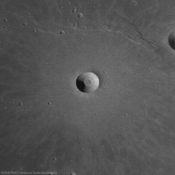
Lichtenberg B (4.86 km; 33.253°N, 298.48°) is a beautifully preserved young impact crater. Rock outcrops in the upper portion of the crater wall are due to the successive thin lava flows that filled Oceanus Procellarum more than 3 billion years ago. LROC NAC mosaic M1162852913LR, LRO orbit 23280, August 16, 2014; incidence angle 35.4° at 1.31 meters resolution, from 129.2 km over 32.46°N, 298.45°E [NASA/GSFC/Arizona State University].
H. Meyer
LROC News System

The lack of atmosphere on the Moon can have its benefits. For example, without an atmosphere, there are few processes to degrade landforms.

On Earth, rain and wind are major causes of erosion, but on the Moon, those causes are absent. Erosion on the Moon is due to impacts that cause shaking and can demolish other craters during formation and to gravity pulling material downslope.

In the case of Lichtenberg B, gravity has not yet rendered the crater smooth and subdued, and there are few impacts nearby, much less any that could have affected the morphology of the crater, as Lichtenberg B appears younger than its neighbors.

Extreme close-up of the wall and rim of Lichtenberg B wall and rim, just east of south center, where impact melt flowed and formed a channel, pushing boulders aside in the process. This 430 meter field of view illustrated "Lichtenberg B Flow," released December 2, 2011. LROC NAC observation M120257109R, February 8, 2010 [NASA/GSFC/Arizona State University].
On the downside, the lack of atmosphere means that space weathering is more efficient on the Moon, and fresh, highly reflective crater ejecta darkens over time. Because Lichtenberg B's ejecta deposit is still bright, it is quite young.

Lichtenberg B and about 56 km-field of view of its surroundings shows an ejecta blanket still highly visible, most than half-way through its long process of optical maturity. LROC monochrome (643 nm) observation M120256944CE, LRO orbit 2856, February 8, 2010; 54.76° incidence angle, 57.42 meters resolution, from 40.39 km [NASA/GSFC/Arizona State University].
Crisp morphology and a highly reflective ejecta deposit make Lichtenberg B stand out from many of the nearby impact craters. This exquisitely preserved crater is located to the northwest of Aristarchus Plateau in Oceanus Procellarum, a vast mare unit littered with impact craters and wrinkle ridges. The ejecta deposit is particularly interesting because it displays a wrinkled texture with structures that resemble dunes.

High-angle (late afternoon) incidence view draws some depth of field to the plains impacted by Lichtenberg B. LROC WAC monochrome (604 nm) mosaic of four observations from sequential passes December 8, 2011; 77° incidence, 56.5 meters resolution from 40 km [NASA/GSFC/Arizona State University].
How do these structures form? What makes Lichtenberg B's ejecta deposit different from other craters that lack these dune-like structures? It turns out that Lichtenberg B is not alone. Scientists have observed these same features at Linné Crater and are in the process of determining how they formed.

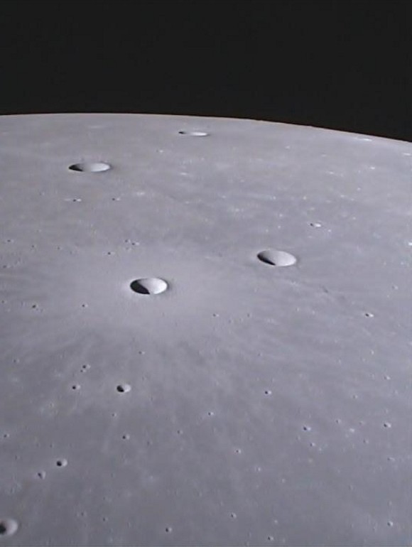
Forward view (north) from GRAIL-A gravity probe Ebb MoonKAM in May 2012, over northwest central Oceanus Procellarum. The maturing ejecta blanket from Lichtenberg B, Dorsum Scilla and Naumann G are in mid-foreground, with Naumann further beyond, and Naumann B (10.72 km; 37.46°N, 299.3°E) is nearer the horizon. ( MoonKAM image 133655 ) [NASA/JPL/SRSC/UCSD].
Check out the full NAC mosaic HERE.

Related Posts:

Friday, August 29, 2014

Tadpole and Lava Tube (NAC DTM)

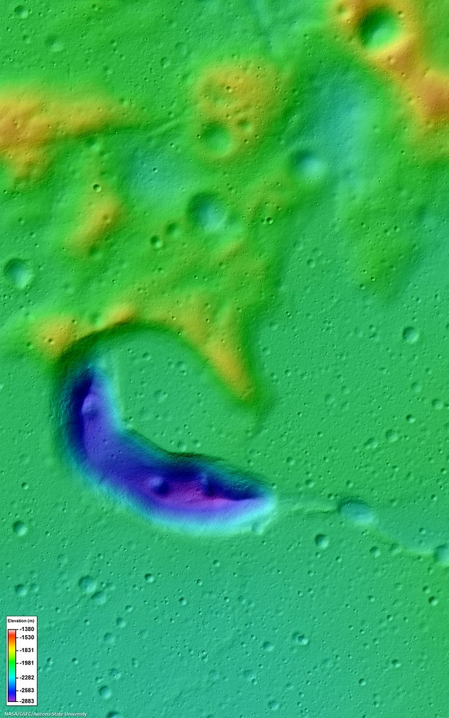
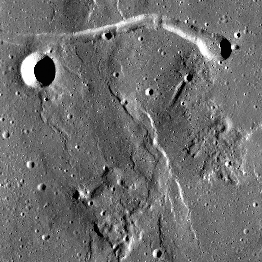
An irregularly shaped depression, resembling a tadpole, first and largest in a sinuous chain of pits. A 14.4 km field of view from LROC Narrow Angle Camera-derived Digital Terrain Model (NAC-DTM) of the tadpole-shaped start of the informally named "Gruithuisen K Sinuous Rille chain" complex in north central Oceanus Procellarum. Color shaded-relief depicts elevation derived from photo-interferometry based on four LROC Narrow Angle Camera observations and resulting in an array of highly granular practical data, packaged into LROC NAC DTM PITVENT; higher elevations are red and white, lower elevations are blue and purple [NASA/GSFC/Arizona State University].
J. Stopar
LROC News System

Today's feature is an irregularly shaped, steep-walled mare depression that looks a bit like a tadpole; it is about 8 km long and located at the northwest end of a 60-km long, sinuous chain of pits (35.284°N, 315.901°E) northwest of Gruithuisen crater.

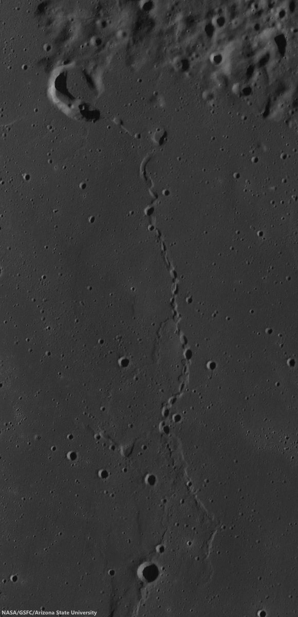
The pit chain was one of the first and most spectacular candidates proposed for an intact lunar lava tube (i.e., one with uncollapsed segments).

This depression may be the source vent for the lava flows that host the pit chain (see image below).

The unnamed first among many candidate features surveyed for hints of underground voids, lava tubes, etc., west of Gruithuisen K crater in north central Oceanus Procellarum. LROC WAC mosaic swept up over three sequential orbits July 12, 2011; 77.2° incidence, resolution 57.9 meters from 42.5 km [NASA/GSFC/Arizona State University].
Volcanic vents tend to be sub-circular or elongate, like today's feature, which is roughly 600 meters deep and has steep inner walls (~35° slopes). Similarly sized and shaped features include examples near Sulpicius Gallus crater and the Orientale basin. Dark, low-albedo, materials surrounding the Sulpicius Gallus and Orientale features suggest formation through explosive pyroclastic eruptions; however, further exploration is still needed to confirm this interpretation.

Collapse pits, with sharp and nearly vertical walls, like the one in the Marius Hills (shown in a previous post) suggest fairly recent collapse of ancient lava tubes. The chain of pits near Gruithuisen, however, has more subdued topography, and likely formed earlier in the history of the Moon (perhaps more than 1 or 2 billion years ago).

An early mission Commissioning LROC NAC observation, covering a cross-section of the sinuous depression chain. LROC NAC M102443238LR, LRO orbit 272, July 17, 2009; incidence angle 77.85° at 1.54 meters resolution, from 155.56 km over 35.47°N, 316.56°E [NASA/GSFC/Arizona State University].
Intact lava tubes have long been thought to be important to future exploration. Many have speculated that uncollapsed portions of lava tubes could be used to shield explorers from harmful radiation, as well as provide a relatively warm and stable environment that is buffered from the large temperature variations at the surface.

Many hope that uncollapsed lava tubes will be located near volcanic materials that can be used in construction or energy-generation processes. However, we still have not explored inside any lava tubes on another planet, though many engineers and scientists are currently working to enable such activities. In the meantime, LROC images combined with other data sets, can be used to search for additional lava tube candidates.

Explore today's tadpole-shaped vent in more detail: LROC NAC M1103837710.

Continue Reading about this fascinating lava tube candidate and the sinuous pit chain, or explore the Sulpicius Gallus vent and Orientale Basin vent in more detail.

Even more to explore:

Tuesday, July 8, 2014

A rille to rover over near Rimae Hevelius

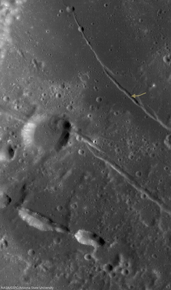
A rille found on the southwestern edge of Oceanus Procellarum, most likely formed from stress added to the surface as mare deposits were emplaced and cooled.  1200 meter-wide field of view from LROC NAC observation M1145219838R, LRO orbit 20802, January 24, 2014; 36.35° incidence, resolution 1.05 meters from 103.39 km over 0.5°N, 295.29°E [NASA/GSFC/Arizona State University].
Raquel Nuno
LROC News System

Remotely sensed data acquired by spacecraft allow scientists to study the geology of other worlds without ever setting foot there.

The investigation of image data is usually the first step in unraveling the origin of a planet’s observed landforms and their evolution -- this scientific study is called planetary geomorphology.

Characterizing geomorphologic features is of the utmost importance for planning both a safely landed mission as well as a rover's path – it would be unfortunate if a rover sent to the Moon got stuck because it was sent to a location it could not traverse. The curved depression in today's Feature Image, called an arcuate rille, is lined with boulders.  This is an example of a landing site that would be hazardous for a rover to land in without a very detailed look at the surroundings.

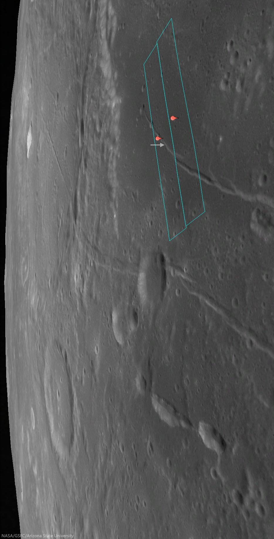
Location of the area viewed at high-resolution in the LROC NAC Featured Image (arrow) on the unnamed arcuate compression rille that runs almost parallel against Rima Hevelius I, longest of the Rimae Hevelius system and extending outward and beyond Hevelius crater, which is outside this 38 km-wide field of view; north of the pyroclastic vent structures near Lohrmann D. From LROC WAC observation M129716592C, LRO orbit 4249, May 28, 2010; 59.3° incidence angle, resolution 58.61 meters from 42.07 km [NASA/GSFC/Arizona State University].
This unnamed rille (0.141°N, 295.362°E), roughly 1 km across, is located on the edge of the southwestern region of Oceanus Procellarum.  As the mare deposits that formed Oceanus Procellarum cooled and contracted, fracture systems developed along the mare-highlands boundary. Near this boundary, loading of denser basalts (mare) over less dense crustal materials (highlands) results in tectonic stresses that can cause rock to pull apart along fractures, forming arcuate rilles.

The footprints of the left and right LROC NAC frames, from which the Featured Image was derived, installed on a digital elevation model and LROC Wide Angle Camera mosaic to offer a simulated 'real world' perspective, putting the the arcuate rille area of interest (arrow) in relation to Rimae Hevelius, inside and outside its namesake crater, and the other complexities of the Lohrmann and Hevelius pyroclastic area of the western equatorial border of Oceanus Procellarum [NASA/GSFC/Arizona State University].
The pattern of some of the complexities at the surface of west and southwest Oceanus Procellarum (and a lot of other areas on the Moon) were at least partially laid bare by the sensitive GRAIL A and GRAIL B gravity probes in 2012. Though the exact boundaries and morphology of the vast nearside basalt flood plain are still poorly understood, it's now clearer that the Moon once had its own "Ring of Fire," less dynamic than on Earth, but still a 'squarish' border in the form of deep volcanic rift structures partially surrounding an enormous plate. The inset shows how this system of rifts explains at least some of the surface faulting, the unique mountains and lateral pressures under the Hevelius, Rimae Hevelius, and the pyroclastic vents near Lohrmann D, and, indeed, much of the the western boundary of Oceanus Procellarum [NASA/GSFC/SVS].
The boulders on the floor of this rille are most likely material that has been eroding away from the walls. Some of the boulders reach diameters up to 12 meters. While an autonomous rover would likely require a lot of time to maneuver amongst the boulders, a human driver on the lunar surface might quickly and easily navigate a safe path around the boulders.

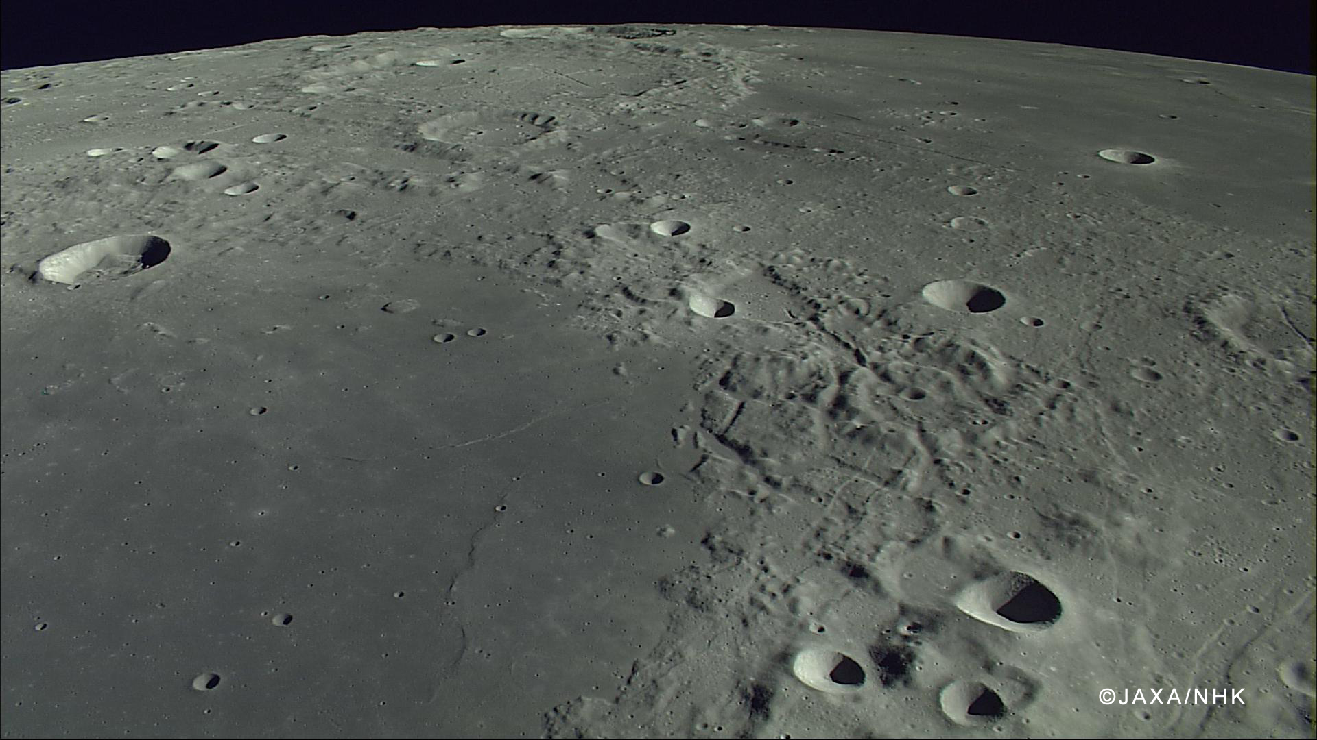
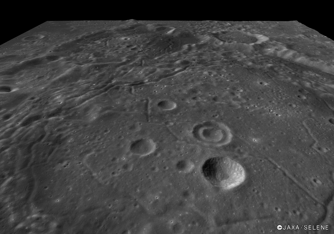
The compression rille is also visible, to the right of the upper center, east of Hevelius, north of the channel linking Grimaldi basin (lower left) with Procellarum (upper right), in this HDTV still captured by Japan's lunar orbiter Kaguya (SELENE-1) in 2007. See the full-size original image, HERE [JAXA/NHK/SELENE].
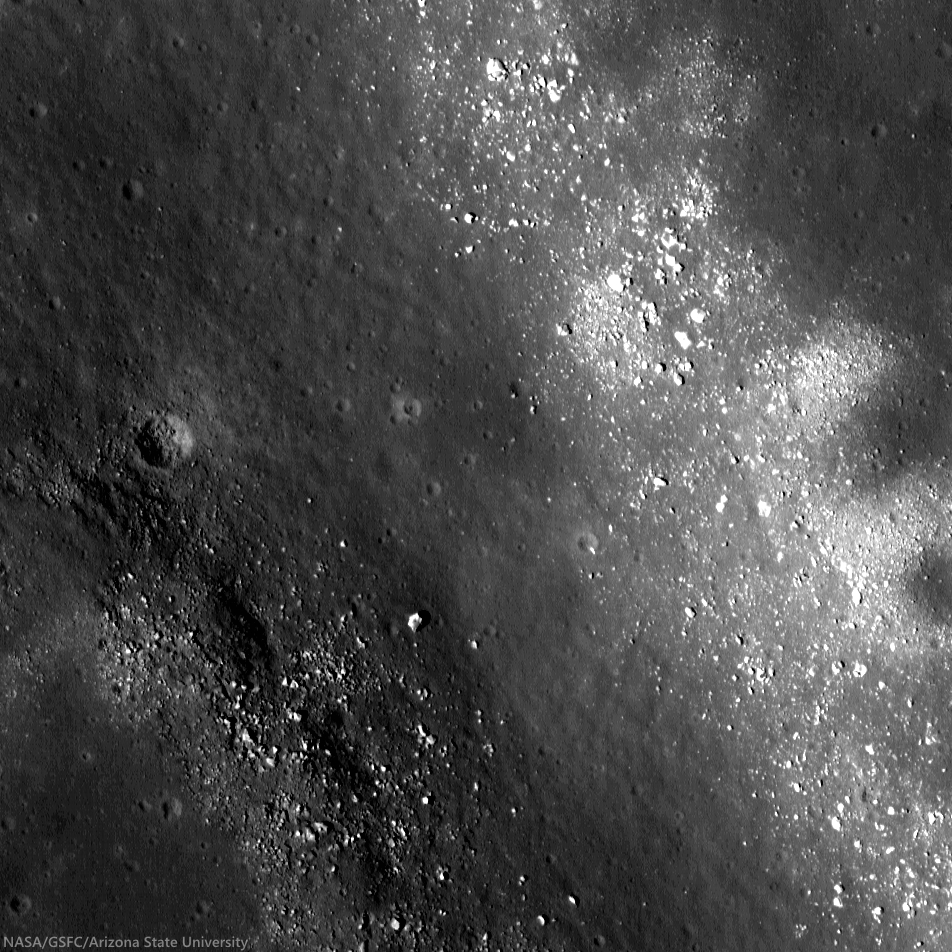
If you were an astronaut on the surface of the Moon, do you think you could find a safe path through this rille?  Trace your path on the full resolution LROC NAC below.

View full-window, HERE.

Related Posts:

Thursday, June 5, 2014

Rima Seuss, rough around the edges

With peppered flanks, Rima Suess wanders over 150 km through Oceanus Procellarum. The rocks that rest on the walls of this sinuous rille are perhaps remnants of much larger boulders that have eroded down to meter sized rocks due to relentless micro and macro meteorite bombardment, "gardening" 3 centimeters into lunar dust every 2 million years or so. The pyroclastic flow that carved through the terrain was remarkably fast, considering the long scar left behind has lasted perhaps 3 billion years. From the extraordinary low altitude of only 23 km (see below), the 400 meter field of view above is cropped from LROC NAC observation M168516400R  [NASA/GSFC/Arizona State University].
Raquel Nuno
LROC News System

Rima Suess (7.81°N, 312.41°E), located in Oceanus Procellarum, is a long, meandering narrow depression called a sinuous rille.

Sinuous rilles, most commonly found in mare surfaces, are thought to have been carved by fast rivers of lava, which thermally and mechanically eroded the channels we see today.

About 3.1 billion years ago the Moon was much more volcanically active, pouring vast amounts of lava onto the surface. The large dark mare regions of the Moon were formed by massive eruptions of iron-rich basaltic lava during this time.

Very close-up on Rima Suess, the LROC NAC observation from which this and the LROC Featured Image were processed was from among one of the closest passes of the Lunar Reconnaissance Orbiter (LRO) over the Moon, during low-periapsis maneuvers in 2011. (Full resolution original image HERE.)  LROC NAC observation M168516400R, LRO orbit 9968, August 12, 2011; 36.11° incidence angle, resolution 39 cm from 22.92 km over 8.07°N, 312.38° [NASA/GSFC/Arizona State University].
The boulders along the walls of the rille probably were a coherent mass when the lava flows cooled, breaking up over billions of years of impacts into the boulders we see today. Gravity then pulled this material down the slope of the rille; this process is known as mass wasting. We see rock outcrops over the entire path of Rima Suess in the LROC NAC image M168516400R.

The very narrow, actually a 200 km-plus-long sinuous rille, apparently traced remarkably fast south from the Marius Hills "Yulu" double-volcano source nearly to Flamsteed P crater, through the bleak center of Oceanus Procellarum. Nearby Kepler crater (outside this view, to the right and east) added the bright ejecta rays. This view is distilled from a mosaic of LROC Wide Angle Camera (WAC) observations swept up over five sequential orbits during local early local morning, allowing long shadows to add some relief to this remarkably flat area of the lunar surface, all of it averaging below 2000 meters in elevation. LROC WAC mosaic from LRO orbits 6838 through 6842, December 18, 2010; 79° incidence angle, resolution 58 meters from 41.5 km [NASA/GSFC/Arizona State University].
Lunar rilles are exciting places for lunar scientists because they may cut through and expose the different layers of lava flows in the maria.  This gives scientists insight into the volcanic processes present during mare formation, and how they evolved with time.

Explore the winding path of this portion of Rima Seuss in the full resolution LROC NAC HERE.

Related Posts:
Rilles as far as the eye can see in Prinz!
Rille within a rille!
Collapsing Tube

Tuesday, April 1, 2014

Lavoisier pyroclastics

Irregular "peanut-shaped" depression, perhaps a former fire-fountain vent, at the head of a floor fracture skirting the western floor of Lavoisier crater, on the west-northwest frontier of Oceanus Procellarum. Low reflectance material, thought to be pyroclastics, appears to have flowed and pooled, eastward and throughout the ancient crater floor. 15 km-wide field of view from a mosaic of LROC NAC observations M105055584L & R, from early in the LRO mission, spacecraft orbit 637, August 16, 2009; resolution 1.6 meters per pixel, incidence angle 57.3° from 162.45 km above 38.32°N, 231.59°E  [NASA/GSFC/Arizona State University].
Raquel Nuno
LROC News System

Lavoisier crater has many geologic forms that give insight into its history. On the floor are concentric craters, which exhibit an inner and outer rim; these strange craters are thought to have formed as a subsurface discontinuity, such as a strong rock layer below loose regolith, which interfered with the passage of the impact shock wave.

Fractures, which are caused by uplift of brittle material, are also abundant and point to subsurface magmatic intrusions or viscous relaxation as possible formation mechanisms.

The peanut-shaped irregular formation, just within the west wall of Lavoisier crater (71 km, 38.17°N, 278.75°E), in an image of the entire crater. Pyroclastic deposits encircle the crater floor, visible as areas of slightly darker appearance in this LROC WAC mosaic stacked from seven sequential monochrome (643 nm) observations by LROC Wide Angle Camera captured after local sunrise November 23, 2010; average resolution 65 meters from 49.5 km [NASA/GSFC/Arizona State University].
Today's Featured Image, found on the western edge of the floor of Lavoisier crater, shows low reflectance material that appears to have flowed from the head of one of these fractures. These flow fronts have been identified by lunar scientists as being the remnants of pyroclastic deposits. The irregular depression is not just another fracture, but a source vent for the eruption that created these deposits!

Context for the context. The west by northwest extremes of Oceanus Procellarum hosts several deposit remnants of fire-fountain pyroclastic volcanism. On the edge of the vast plains to the east and farside highlands to the west, dykes of volcanic faulting offer clues to the long-sought definitive origin for the Procellarum basin that, like Mare Tranquillitatis, does not seem to have formed from a single basin-forming impact. Breakthrough data was collected by the sensitive GRAIL A and B probes. Image stacked from from seven sequential orbital monochrome (643 nm) observations by LRO LROC Wide Angle Cameras of the region, soon after local sunrise, November 23, 2010; average resolution 65 meters, from 49.5 km [NASA/GSFC/Arizona State University].
The eruption (or eruptions) that threw these pyroclastic deposits out onto the surface are thought to be an energetic style of volcanic eruption called fire fountains. Eruptions like this are more chaotic due to the presence of volatile elements in the magma. Since magma source regions are hundreds of kilometers below the surface, pyroclastics are of interest to scientists because they provide information about the deep interior at the time of eruption. Understanding the distribution and composition of these deposits provide a path to deciphering the evolution of the interior conditions of the Moon through time. The Lavoisier pyroclastics and many other similar deposits are key sites for future robotic and human exploration.

Investigate the mantling of pyroclastics over the crater floor up close with the full resolution NAC mosaic, HERE.

Related Posts:
Lavoisier Crater
Pyroclastic Excavation
Layer of Pyroclastics
Pyroclastics and Vent
Hyginus Crater and Pyroclastics

Tuesday, February 4, 2014

Lavoisier crater

Floor of Lavoisier crater
LROC NAC mosaic of the the fascinating floor of Lavoisier crater. A concentric crater is seen in the lower left corner of the image, and fractures trending northwest to southeast. 10 km field of view from LROC Narrow Angle Camera (NAC) mosaic M1114711232, LRO orbit 16511, February 5, 2013; 49.9° incidence angle, resolution 1.4 meters per pixel from 141.96 km [NASA/GSFC/Arizona State University].
Raquel Nuno
LROC News System

Many intricately fractured crater floors are found in the northwestern portion of Oceanus Procellarum, near the boundary between mare and highlands.

Today we peer into one of these, Lavoisier (70 km, 38.17°N, 81.25°W). Most floor-fractured craters (FFCs) occur in or near ancient basins; some of the basins were flooded with mare basalt. We see three fractures in the image above: one running diagonally trending northwest to southeast, the second running almost parallel and through the rim of a concentric crater, and the third at lower right perpendicular to the first.

These fractures not only cut across the floor center, but they are also found skirting the walls of the crater on the floor. One proposed formation mechanism is post-impact modification by volcanic related activity, such as magmatic intrusion. The other proposed mechanism is viscous relaxation.

HDTV sequence, north over the western edge of Oceanus Procellarum and Lavoisier crater

Floor of Lavoisier crater (Kaguya TC)
View south over the fractured floor of Lavoisier, from the Terrain Camera (TC) of Japan's lunar orbiter Kaguya (2007) [JAXA/SELENE].
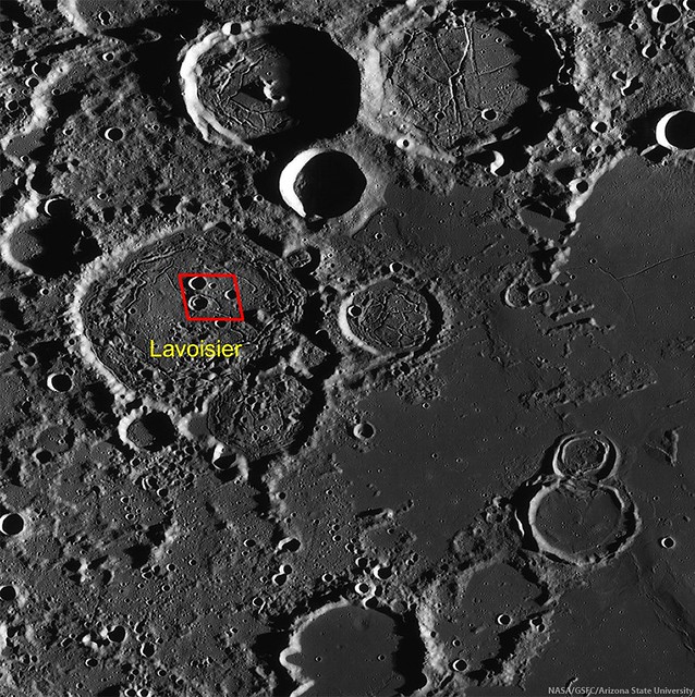
Much like floor fractured craters, concentric craters are often found near mare/highlands boundaries. Today's Featured Image includes an example of a concentric crater. Concentric craters contain an inner rounded rim whose formation mechanism is not entirely understood, see the WAC context image below. One theory is that concentric craters are the surface expression of a subsurface discontinuity, such as a layer with different mechanical properties. However, as we look in our Featured Image adjacent to the concentric crater, we see a similarly sized (~6 km) crater that does not exhibit concentricity! If the concentric crater was formed by an impactor hitting a layered target, it would mean that the layering was extremely localized, otherwise the adjacent crater would also be concentric. Another proposed formation mechanism is uplift from magmatic intrusions.

Fracturing west-northwest Oceanus Procellarum (LROC WAC)
LROC low Sun (high incidence angle) LROC Wide Angle Camera (WAC) mosaic of a 250 km-wide portion of the west-northwestern edge of Oceanus Procellarum. The area visible in the LROC Featured Image released February 4, 2014 is roughly outlined in red [NASA/GSFC/Arizona State University].
So we don't have the whole story yet, but scientists are hard at work trying to understand these processes. Geologists are studying the morphologies and compositions of lunar features, theorists/dynamicists are computationally simulating the cratering process, and experimentalists try to replicate these craters in the laboratory with high energy events. One day, on-site investigations of the lunar subsurface will also assist in determining the origin of the myriad of features seen across the lunar landscape.

If you were to go to Lavoisier crater, which structures would you like to study? Pick them out by surveying the full resolution NAC mosaic, HERE.

Related Posts:
Oblique Image of Concentric Crater
Concentric crater
Karpinskiy Floor Fractures
Alphonsus crater mantled floor fracture
Bah Humboldt!
A Colorful History of Floor-Fractured Komarov
Ocean of Storms, Oceans of Argument Paul Spudis, November 3, 2012

Wednesday, January 15, 2014

Hansteen α

Hansteen α (LROC NAC)
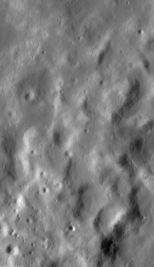
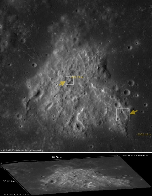
Close up on the heights (-923.8 elev.) of Hansteen α (AKA, "Mons Hansteen" and "the Arrowhead"), a triangular berg, 25 km long on its three margins, composed of intrinsically bright material and rising here 1030 meters above its neighborhood in south Oceanus Procellarum.  LROC Narrow Angle Camera (NAC) periapsis observation M166175569LR, spacecraft orbit 9623, July 24, 2011; 61.74° incidence, slew 16.45° west, resolution 0.5 meters from 41.05 km (Enlarged image HERE.) [NASA/GSFC/Arizona State University].
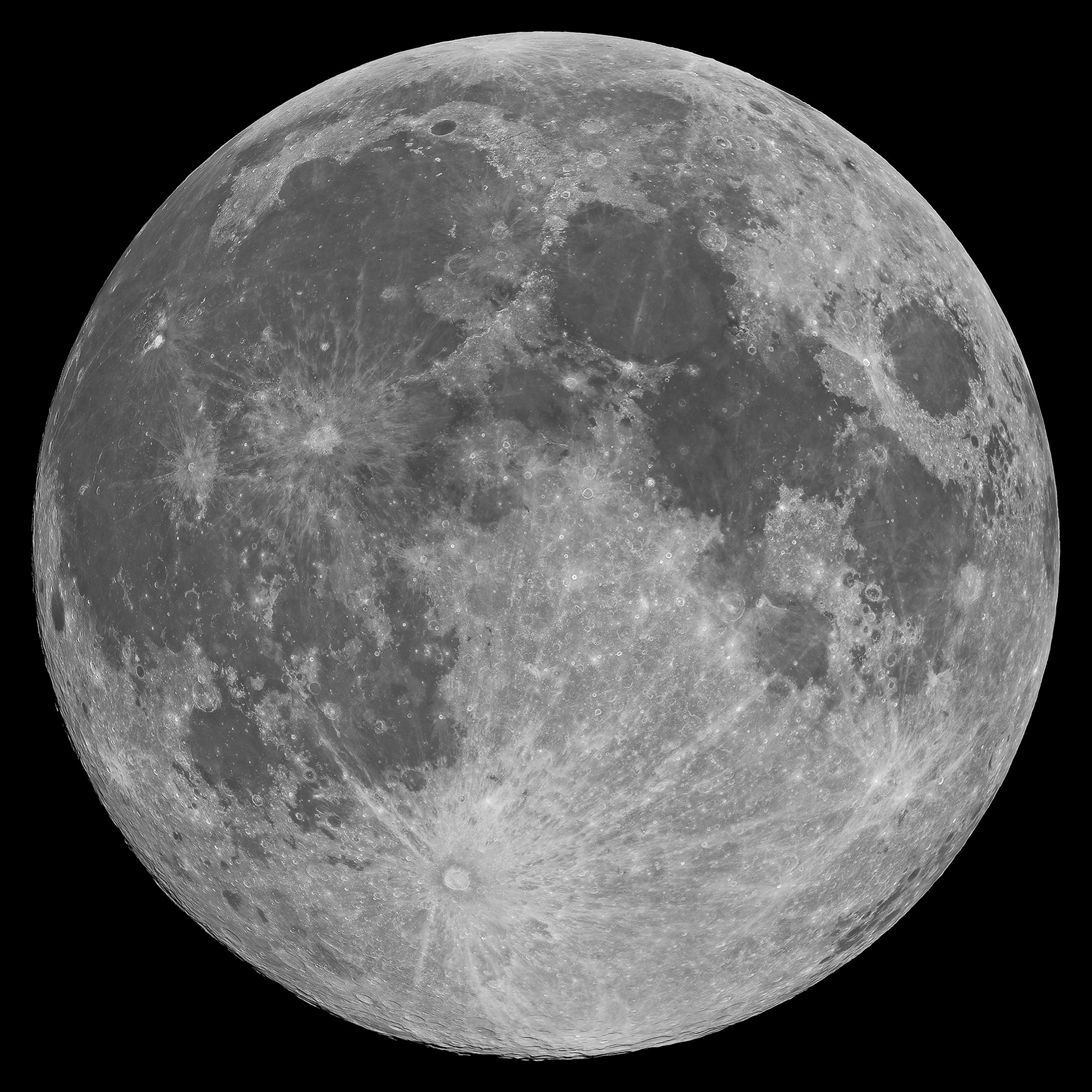
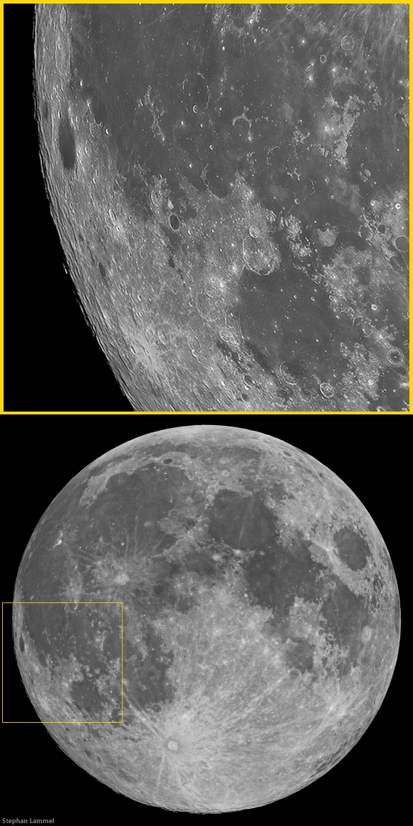
Mons Hansteen (12.2°S, 50.21°W) is a familiar nearside landmark, when viewing a Moon that's almost Full through a modest telescope. As the reader can see in the picture of the Full Moon at the end of this post, it stands out from its surroundings in the far south Oceanus Procellarum.

It's nicknamed "the arrowhead" because it looks like one, like, long-ago, it was knapped to a point by the patient hand of a hunter and now rests half buried in the darker mud of a trail, perhaps uncovered by a recent downpour.

Close investigations of the Moon over the past half century reveal what investigators call "Hansteen Alpha," or Hansteen α, stands out geologically and in other ways. The small mountain is made of different stuff than most of what is found on the lunar surface and the volcanism that flooded and re-flooded the Moon's basins. It's optical brightness is complimented by differences at other wavelengths as well, presenting a spectral profile found in only a few other locations on the Moon. 

Hansteen α is one of the Moon's red spots, bright with an albedo similar to the lunar highlands but spectrally red, brighter in shorter wavelengths and characterized by absorption in the ultra-violet (UV). 

Moreover, it must be a younger feature than it might seem on first glance, younger than certain of the larger craters nearby and other features in its neighborhood that were clearly overrun repeatedly by the darker basaltic lavas that periodically flooded and re-flooded the lower elevations over a period nearly three billion years long.
Hansteen α (LROC NAC)
The heights in the first image are at lower right in this 3.94 km-wide field of view, the full width of the area captured from LRO in LROC NAC M166175569LR, and showing a cross-section of Hansteen α from that central area north to more lower elevations, nearer the mountain's northwestern margin. (View larger sizes HERE.) [NASA/GSFC/Arizona State University].
Hansteen a (LROC WAC 250m)
Hansteen α is younger than craters Billy (45.57 km across and 3.88 billion years old, to the south) and Hansteen (45 km across and 3.87 billion years old, to the west), because both are less than one and a half times their respective diameters in distance, and the impacts that excavated these features should have at least partially covered the bright mountain. Instead, no evidence of such a direct effect has been found, only peppering of more recent impacts. LROC Quickmap at 250 meters resolution [NASA/GSFC/Arizona State University].
Hansteen α resembles the Moon's highlands but, beginning early in the post-Apollo era, investigators noted differences in texture, color and measured albedo. In the close-ups at the beginning of this post, showing some of the highest elevations of Hansteen α, depressions can be seen clustered on terraces. These seem to have once been volcanic vents.  Volcanic vents are not particularly rare on the Moon, but the kind of material that emerged from these is clearly not the same stuff that flooded its surroundings.
LROCQM064-H-a-580x746
A closer look at Hansteen α elevations, with locations marked of areas shown in LROC NAC observations posted here, the highest elevations and, further along along, some solidified flows on the steep southeastern margin, included below. LROC Quickmap at 64 meters resolution, together with the LROC WAC-derived digital terrain model [NASA/GSFC/Arizona State University].
Using an experimental 3D visualization tool, accessed through the LROC Quickmap. a 152 square km area, centered on Hansteen α, animated between 0 and 10 X vertical exaggeration, further illustrating highest elevations, southwest of the formation's center; something more difficult to measure using 2D overhead photography [NASA/GSFC/Arizona State University].
The margins of Hansteen α seem abrupt, with steeper slopes than is found around the edges of the more common basaltic domes. This might be in keeping with suggestions that the kind of lava emerging into and out of this feature was thicker, related to its composition and the heat necessary for melting and transport. It also provides geologists with clues about its age relative to the volcanism that flooded Procellarum in this region.  

The Hansteen α might have formed from a "secondary," and "more evolved" volcanism, something certainly less common than the basaltic lavas that flowed out into the Moon's broad basins, not once but repeatedly, over a 2.7 billion year period, from the Nectarian age, when the Moon and Earth were only 600 million years old, until just prior to the Copernican period 1.2 billion years ago.

These more recent high-resolution images from LRO show groupings of blocky boulders, mostly related to mass wasting along slopes though some of these clusters are found on level areas and don't appear to be the result of impacts.
Intrusive volcanism Hansteen Alpha
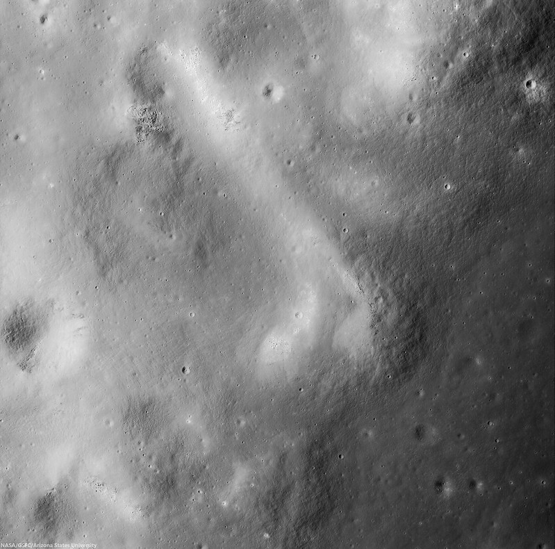
An intrusive flow, clearly visible on the abrupt southeastern margin of Hansteen alpha,  right where it solidified, This is a 3.93 km square field of view from LROC NAC observation M1129816872R, orbit 18636, July 30, 2013; 42.35° incidence, 80 cm per pixel resolution from 80.7 km over 12.2°S, 310.14°E  [NASA/GSFC/Arizona State University].
Intrusive volcanism Hansteen Alpha
Contextual view of the full 7.8 km-wide field of view swept up in the same LROC NAC  observation, showing a wider view of southeast margin of Hansteen α. Such close-ups reveal that the margin here is more abrupt than it seems at a distance. (Enlarged views and various other sizes available HERE.) [NASA/GSFC/Arizona State University].
So, just what is Hansteen alpha? In two papers presented in 2011 and 2012 to the Lunar and Planetary Science Conference, Hawke, et.al., representing some of the more noted investigators working with data returned from LRO (the more recent of these being  "The Geology and Composition of Hansteen Alpha," 43rd Lunar and Planetary Science Conference (2012), #1754), wrote, "Non-mare volcanism is the only viable process for the formation of Hansteen α."

That paper, along with others those investigators cite, along with still others cited as references below, present truly fascinating discussion of how instruments on-board Clementine (1994), Lunar Prospector (1998-99) and both the LROC cameras and the Diviner instrument, flying on LRO since 2009, are actively being used to weed out the history of this unique feature and how it relates to the complicated volcanic stratigraphy of the Procellarum basin.
Finding Hansteen alpha (Mons Hansteen)
Finding Hansteen α through a modest telescope is relatively easy, from about four days after First Quarter through three days after Last Quarter, on the south edge of Oceanus Procellarum, as shown in this well-crafted mosaic by Stephan Lammel. Look for it left of center in the inset and in the Full Moon, above.
References:

Related ASU LROC Posts:
The Fourth Marian Dome (April 17, 2013)
Aristarchus Spectacular! (December 26, 2011)
Silicic volcanism on the Moon (February 14, 2011)

Tuesday, November 5, 2013

Diversity of basaltic volcanism and the Marius Hills

MARIUS Hills, Sinuous Rille A
A diverse range of volcanic morphologies: a sinuous rille, blocky lava flows and pyroclastic cones found in a portion of the controlled LROC NAC mosaic "NAC_ROI_MARIUS_ _LOC_E138N3037" centered on 13.476°N, 303.861°E, field of view approximately 21 kilometers wide [NASA/GFSC/Arizona State University].
J. Stopar
LROC News System

The Marius Hills region (located at 306.2°E 13.0°N) is known for its diverse and complex volcanic features: extensive mare basalt plains, small shield volcanoes, steep-sided cones possibly constructed from cinder or spatter, and sinuous rilles. One of these rilles has a small (approximately 50 m in diameter) pit in its floor, possibly a skylight opening into a lava tube. Today's featured image is a low-sun angle controlled mosaic of part of the Marius Hills region created by combining three LROC NAC left and right image pairs with similar lighting conditions (acquired on adjacent orbits). To create an accurate mosaic, a control network is used to tie the images together and correct for camera pointing and spacecraft position over the lunar surface (refer to the RDR description for more details). Today's featured mosaic illustrates all the major volcanic landforms found in the Marius Hills. 

The full mosaic can be downloaded HERE.

NAC_ROI_MARIUS__LOC_E138N3037_5M-1920x3574
Thumbnail of complete controlled NAC mosaic "NAC_ROI_MARIUS_ _LOC_E138N3037" (down-sampled for web browsing) shows a larger area of the western Marius Hills region and a broad sample of its volcanic morphologies [NASA/GSFC/Arizona State University].
Two large sinuous rilles nicknamed "A" (larger, more southern rille in mosaic above) and "B" (smaller, more northern rille in mosaic above) by Greeley (1971) each have a source at a localized volcanic center within the Marius Hills and are embayed (overlapped) by younger mare basalts to the west. Rille "A" contains the Marius Hills skylight feature that was previously discussed in Featured Images Marius Hills Pit and Sublunarean-void!. This pit or skylight is intriguing because it suggests that many other lunar rilles may also have lava tubes or might be formed through lava tube collapse.

M114328462R4-2880
Section of today's featured mosaic that shows the Marius Hills pit crater skylight (center). Try to find this feature in the full mosaic. (Hint: the skylight appears darker and more shadowed than normal impact craters in this mosaic) [NASA/GSFC/Arizona State University].
M137929856R_thumb-750
Oblique view of the Marius Hills pit crater, originally discovered by Japan's Kaguya lunar orbiter in 2007, LROC NAC imagery soon revealed others, most notably in Mare Tranquillitatis and Mare Ingenii. LROC NAC observation M137929856R [NASA/GSFC/Arizona State University].
The volcanic shields, which are sometimes called domes due to their steep and abrupt margins, are constructed from short and blocky lava flows, but are probably not true volcanic domes. Observations from Clementine and LRO indicate that the blocky lava flows are generally basaltic in composition (e.g., Weitz and Head 1998; Lawrence et al. 2013) even though they appear thicker and shorter than the mare-style volcanism that dominates the lunar nearside. The shorter and less voluminous blocky flows likely result from slower eruption rates and more viscous lava.

MHdome_crop_sm-2000x1000
Two examples of small shields that are primarily constructed from blocky lava flows. Try to find these features in today's featured mosaic [NASA/GSFC/Arizona State University].
The numerous volcanic cones found in the Marius Hills region are atypical for the Moon, though other examples do exist. The steep flank slopes (near 16°) and circular to elongate shapes in plan view (often C-shaped) suggest construction from pyroclastic materials, often called cinder and spatter, like similarly sized and shaped features on Earth. The Marius Hills cones range in size from a few kilometers to 500 meters in diameter. Many of the cones have blocky lava flows that appear to emanate from their central vent, resulting in a C-shaped cone.

MHcone_crop_sm-2704x1000
Examples of C-shaped and elongate volcanic cones, these cones are often found in association with blocky lava flows. Try to find these (and more) pyroclastic cones in today's featured mosaic [NASA/GSFC/Arizona State University].
M150877632LR-03-04-adjust-scld-1920x1203
LROC NAC high-resolution view of "the love seat" among the Marius domes, from an assembly of 28 LROC NAC cropped images and slideshow, HERE [NASA/GSFC/Arizona State University].
The diversity and complex spatial and stratigraphic relationships of rilles, cones, and shields in the Marius Hills region makes it difficult to determine if eruption conditions changed over time. But, in general, the small shield volcanoes, blocky lava flows, and pyroclastic cones were probably formed nearly synchronously. Later, floods of mare lava partially overprinted the region, leaving only the uppermost peaks for us to observe today.

A gif animation showing the junction of the Reiner Gamma swirl and the southwest Marius Hills region under a variety of illumination angles, highlighting topography and albedo [NASA/GSFC/Arizona State University].
Today's featured image presented only one of the many controlled mosaics collected and produced by the LROC Team! Explore the more than 80 other controlled mosaics of various lunar terrains currently available on the RDR Products website.

Related Posts:
Marius Hills Survey (Slideshow)
Rima Marius Layering (June 2, 2013)
Discontinuous Rilles (May 15, 2011)

Tuesday, September 24, 2013

On the edge of Lichtenberg

M1108660598RL-NSJ-0108-58b-9383x12942
An oblique view of Lichtenberg crater (31.854°N, 292.284°E). LROC Narrow Angle Camera (NAC) M1108660598RL, a 9526x15400 mosaic, captures a side-glance view (spacecraft and camera slewed -53.22° off nadir) of the geologically anomalous Lichtenberg crater, on the northwestern side of Oceanus Procellarum. LRO orbit 15660, November 27, 2012; overall resolution above 3 meters per pixel, early morning angle of incidence 81.38° from 142.54 km over 32.1°N, 300.76°E [NASA/GSFC/Arizona State University].
H. Meyer
LROC News System

Lichtenberg crater (19 kilometers in diameter) is located in western Oceanus Procellarum (31.85°N, 292.28°E). Originally thought to be Copernican in age due to its visible ray system,

Lichtenberg is now thought to be Eratosthenian in age. It turns out that Lichtenberg rays are highly reflective due to their composition and not their relative youth (compositional ray vs maturity ray). Today's Featured Image is an oblique view of Lichtenberg crater and the surrounding terrain. Oblique images are similar to what an astronaut in orbit around the Moon would see looking out a window towards the horizon, and these views are different than most of the LROC NAC images that are taken at nadir (looking straight down).

Lichtenberg crater, super-positioned on the vast basalt flooded nearside plains of Oceanus Procellarum that are, in turn, superimposed nearly over a more ancient, larger "ghost crater" to the northeast. Lichtenberg was originally selected as a Constellation Region of Interest (ROI) for, among other reasons, a distinct younger flow of melt superimposed on the crater's southeastern frontier, demonstrating this part of Procellarum was inundated both before and after Lichtenberg's formation. LROC Wide Angle Camera (WAC) monochrome (604 nm) mosaic from observations collected in sequential orbits July 27, 2011, from approximately 43 km overhead. View a wider field of view in the original mosaic HERE [NASA/GSFC/Arizona State University].
Because oblique images are taken by looking at an angle, these images can enhance or reveal features that may not be evident when looking straight down. For example, Lichtenberg's raised rim is prominent in this image, as is the topographic high within the ghost crater beside it. The diameter of the ghost crater (29 kilometers) suggests that it is a complex crater with a central peak that was subsequently buried by mare basalts. Perhaps a now deeply buried central peak is reflected in the surface as a distinct topographic high in the center of the ghost crater? It is the presence of this flooded crater that caused Lichtenberg to form in an asymmetrical fashion. This viewing geometry also enhances Lichtenberg's textured ejecta blanket, revealing a partial embayment of the ejecta on the eastern side. By applying our understanding of the principles of stratigraphy, the history of this area can be unraveled. A complex crater formed on the surface and was buried by mare basalt. Then, Lichtenberg formed on part of the partially buried rim of the ghost crater. Finally, a new flow of mare basalt partially flooded the ejecta of Lichtenberg.

Explore the full NAC mosaic HERE.

Related Posts:
Ghost Crater in Southern Mare Crisium (June 21, 2011)