Showing posts with label Shackleton. Show all posts

Monday, April 8, 2013

The Mystery of Shackleton Crater

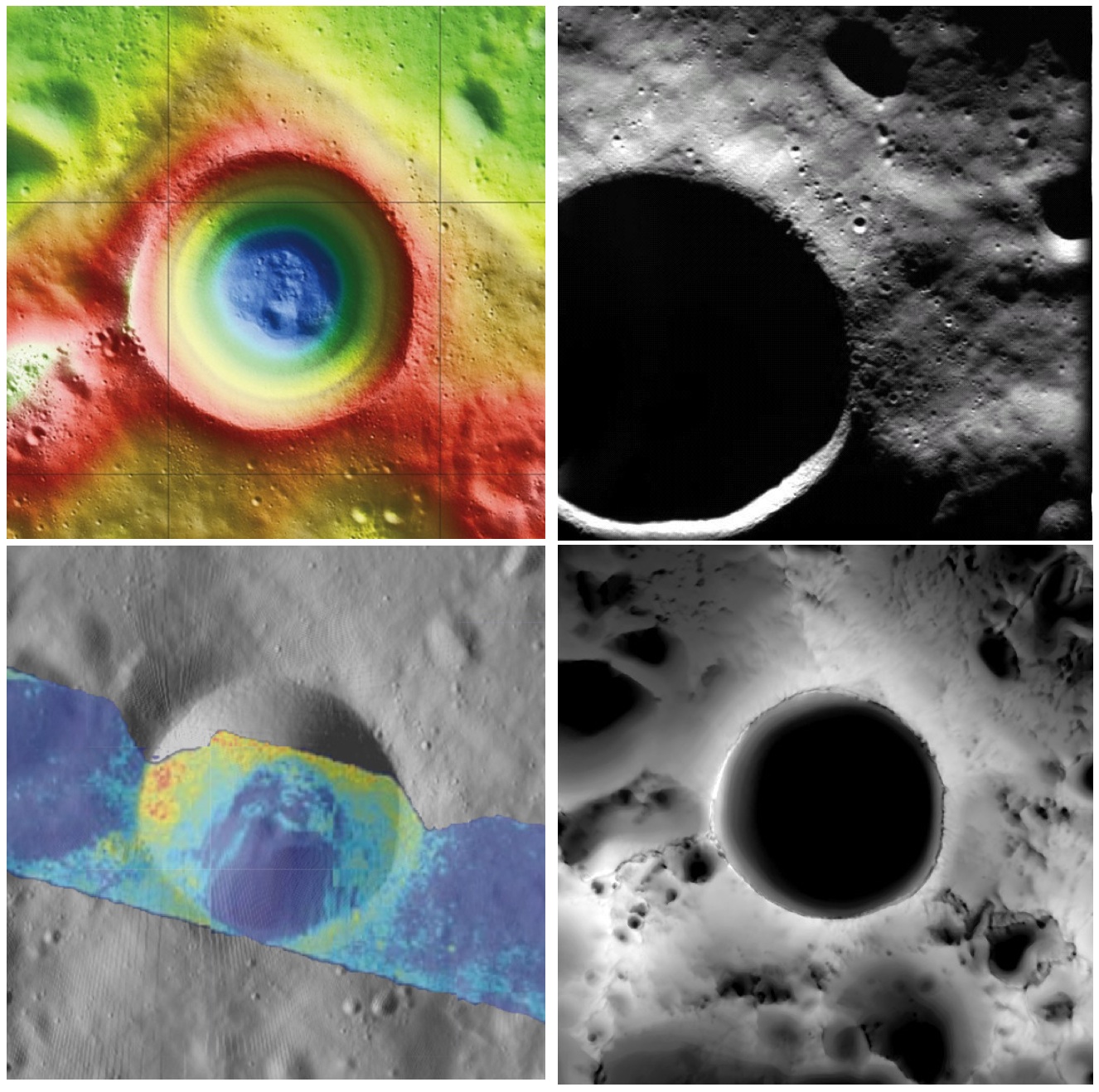
Shackleton crater, Earth's Moon. Clockwise from top left: topography from (LOLA) laser altimetry, photography from ESA SMART-1 mission, lighting map (relative isolation - brighter indicates longer periods of illumination) from LROC data, Mini-RF Circular Polarization Ratio (CPR) image draped over shaded relief. The crater is about 20 km across.
Paul D. Spudis
The Once and Future Moon
Smithsonian Air & Space


Though unremarkable in appearance compared to the roughly 4,000 craters on the Moon in its size range, the 20 km diameter crater Shackleton has been the source of relentless scientific controversy for the past 20 years.  Shackleton is located at the south pole of the Moon; indeed, its near side rim is the precise location of the geographic pole itself.   Its location makes observation by Earth-based telescopes difficult and it was not well photographed by the Lunar Orbiter series (our principal source of lunar images) of the 1960s.  That all changed in 1994 with the flight of the joint DoD-NASA mission to the Moon, Clementine.

Clementine carried cameras that globally imaged the Moon in eleven visible and near-infrared wavelengths.  In addition, it mapped the surface and lighting of the poles of the Moon at uniform resolution over the course of almost three lunar days (74 Earth days).  When the Science Team first saw the south polar mosaic, the extent of darkness in the map was striking.  Because the Moon’s spin axis is close to perpendicular to the ecliptic plane, the Sun is always at the horizon at the lunar poles.  Instead of rising and setting, the Sun circles around the poles at or near the horizon.  Because of this grazing incidence, an area in a topographic depression may be in permanent shadow.  And so it appeared for Shackleton crater in the Clementine data, setting off bells in the heads of the Science Team.

Intuitive selection from HDTV still frame captured by Japan's lunar orbiter SELENE-1 (Kaguya) in 2008 shows Shackleton, with the Moon's south pole on its rim (upper left) in relation to Earth and Malapert Massif, part of the nearside rim of the ancient South Pole-Aitken impact basin, along the line of sight. Shackleton's interior and the craters between it and Malapert, are permanently shadowed interiors (PSR), unmapped before the 21st century [JAXA/NHK/SELENE].
A key controversy of the post-Apollo era was whether the lunar poles might contain water or not.  Although the Apollo samples had been studied and found to be “bone-dry,” we had not been to the poles on any Apollo mission.  We knew that any shadowed areas had to be extremely cold as well as permanently dark.  As water-bearing debris in the form of asteroids and comets constantly strike the Moon, it was thought that some of that water might get into a polar “cold trap” and would be kept there (essentially) forever – billions of years of impacting cosmic “debris” can add up.

Clementine was not configured to measure the presence of water, but a cleverly improvised experiment used the spacecraft’s data transmitter to beam radio waves into the dark regions near the poles and listen to their reflected echoes on the enormous (70 m) dish antenna of NASA’s Deep Space Network.  Interestingly, the reflections indicated an enhancement of “same sense” polarization within the (very large) resolution cell that contained Shackleton crater.  A collect of data from a nearby sunlit area (taken as an experimental control) did not show this peak.  The Clementine team interpreted the RF peak as evidence for the presence of a few percent water ice within the dark, cold interior of Shackleton crater.  The media quickly spread the startling news about water on our “bone-dry” Moon.

Shackleton, as seen in a joint 70 mm radar experiment collected by radio telescopes at Greenbank and Arecebo during a favorable libration opportunity in 2006.
Such a controversial conclusion did not go unchallenged.  Some in the radar community argued that abundant wavelength-sized rocks on the surface were the source of the enhanced same sense reflection.  Since the lunar surface is indeed rocky, this interpretation could not be ruled out.

Then a few years later, the Lunar Prospector (LP) mission found an enhancement of hydrogen concentration at both poles of the Moon; as hydrogen is a major constituent of water, the idea ice exists in the dark areas gained credence and has lead to a decade-long scientific search (using a variety of techniques) for lunar polar ice.  Though many areas near the poles were studied in detail, attention continued to be drawn back to Shackleton and the area near the south pole.

From studying Clementine images, we discovered that part of the rim crest of Shackleton is one of the most sunlit areas on the Moon.  Now we had a double-attraction: constant sunlight with water ice nearby.  At a press briefing in 1996, I called this area of water and sunlight “the most valuable piece of real estate in the Solar System.” Nothing found subsequently has changed my mind on that judgment.

So what have we learned about Shackleton lately?  Many different, new sensors have flown to the Moon in the last few years, including radar, ultraviolet (UV) imaging, laser reflections, and low-light level imaging.  And yet again, Shackleton crater continues to confound us with contradictory evidence, both for and against the presence of water ice in its interior.

In 2009, the question regarding the presence of water ice somewhere near the lunar south pole was answered when the LCROSS impactor threw up a cloud of water vapor and ice particles during its collision with the floor of the nearby crater Cabaeus.  Spectral mapping instruments on three different spacecraft (Chandrayaan-1, Cassini, and EPOXI) documented the presence of adsorbed water on the lunar surface, increasing in concentration with latitude toward both poles.  A small impact probe flown by India (MIP) passed through a water vapor zone in the exosphere just above the lunar south pole.  And radar images from Mini-RF, our radar imaging experiment on both Chandrayaan-1 and Lunar Reconnaissance Orbiter (LRO), found evidence of high same sense reflections (just as Clementine had suggested in 1994) within the interior of Shackleton crater.

LRO Mini-RF instrument radar data indicate the walls of Shackleton crater may, indeed, hold ice, confirming exacting measurements of laser altimeter (LOLA) point brightness studies revealed in June. Actual observations (CPR) are compared to calculated radar values for 0.5% to 10% ice. Illustration to post "Mini-RF adds to evidence of ice on Shackleton walls," September 1, 2012 [NASA ].
These new lines of supporting evidence were countered by Japanese researchers, whose Kaguya spacecraft imaged the interior of the crater and found morphology similar to other lunar craters in the same size-class.  But no one had ever claimed that the interior of Shackleton was a skating rink of pure ice – the lunar polar ice is partly covered by waterless dust and mixed with an unknown amount of dry regolith.

Interpretation of the new data continues to vex us.  The LOLA (laser altimeter) team on LRO recently published a paper that documents the high reflectivity (at 1 micron wavelength) of the walls of Shackleton.  Although the team’s favored interpretation is that this is caused by a constant exposure of fresh material on a steep slope, they also note that it is consistent with the presence of water ice on the walls of the crater.

In addition, a team analyzing neutron spectrometer data from both LP and LRO found evidence in the fast neutron data (never before analyzed) that water in the interior of Shackleton is a possible explanation for its signal.  Detailed analysis of the Mini-RF data for Shackleton corrected for its steep wall slopes and found that the presence of 5-10 wt.% water there provides the best model fit to the observed data.  Newly obtained UV images from LRO show the existence of water frost in the interiors of the craters Haworth and Shackleton, and the neutron detector on LRO shows enhanced hydrogen within both Shoemaker and Shackleton craters.  The Japanese team from Kaguya continue to insist that the no-ice interpretation is the correct one.

So we are left with a mystery.  Some evidence is pro-ice and some is contra-ice.  I find it interesting that for most of the investigators, new data does not necessarily change any minds, but tends to be interpreted in a way most favorable to their previously published ideas.  This should not be terribly surprising; the people who have argued for some specific interpretation presumably did so for good reasons and desire hard and clear-cut evidence to the contrary before abandoning a previously held position, one no doubt reached after much thought and soul-searching.

Less so, but still-mysterious Shackleton, "twice as deep as the Grand Canyon," from "Tour of the Moon," a 2:30 video prepared by the Science Visualization Studio (SVS) at Goddard Space Flight Center in 2012 [NASA/GSFC/SVS].
The way to unravel the water-ice mystery is to go to the surface of the lunar south pole (or both poles) and measure the composition of the surfaces in question.  Getting a definitive answer about the nature of lunar water would be game changing.   Some say the bigger mystery is:  Why hasn’t the United States sent a rover to the south pole of the Moon to take a closer look?

Originally published April 8, 2013 at his Smithsonian Air & Space blog The Once and Future Moon, Dr. Spudis is a senior staff scientist at the Lunar and Planetary Institute. The opinions expressed are those of the author but are better informed than average.

Related Posts:
Mini-RF adds to evidence of ice on Shackleton walls (September 1, 2012)
Shackleton harbors ice after all (June 12, 2012)
1000 Day Anniversary of LROC Imaging (March 27, 2012)
Shackleton on a Summer's Day (March 26, 2012)
Shadowed fluffy lunar frost detected in starlight (January 14, 2012)
Shackleton: Out of the Shadows (September 17, 2009)

Wednesday, November 21, 2012

ESA Lunar Lander mission axed

The EADS Astrium - European Space Agency (ESA) Lunar Lander, clinging to a 2018 landing, possibly on the rim of lunar South Pole crater Shackleton, is likely scrubbed [EAS/Astrium].
Germany's DLR has reportedly given up advocating the 2018 south polar Lunar Lander mission as ESA member nations struggle with dire discretionary budget constraints in the midst of an on-going sovereign debt crisis.

Germany dropped further efforts to secure joint European funding for Lunar Lander at an ESA budget meeting in Naples in favor of upgrades to the Ariane 5.

Meanwhile, following NASA's exit from the ExoMars orbiter-rover mission, in development since 2005, Russia's Federal Space Agency Roscosmos has become ESA's new launch partner, set to launch the orbiter half of that mission in 2016 and its tandem six-wheeled rover two years later.

Related Posts:
ESA input sought on multi-purpose lunar lander (March 2, 2009)
Astrium study of ESA NEXT lunar lander underway (June 10, 2009)
Remembering SMART-1 (September 17, 2009)
ESA: Fly us to the Moon's South Pole (March 31, 2010)
NEXT step for ESA's first lunar lander (September 16, 2010)
Astrium tests ESA Lunar Lander thrusters (March 5, 2012)
ESA's MoonNEXT boosted by ATV development (April 30, 2012)
ESA Lunar Lander still on target for 2018 (July 27, 2012)

Saturday, September 1, 2012

Mini-RF adds to evidence of ice on Shackleton walls

LRO Mini-RF instrument radar data indicate the walls of Shackleton crater may, indeed, hold ice, confirming exacting measurements of laser altimeter (LOLA) point brightness studies revealed in June. Actual observations (CPR) are compared to calculated radar values for 0.5% to 10% ice [NASA ].
Scientists using the Mini-RF radar on NASA's Lunar Reconnaissance Orbiter (LRO) have estimated the maximum amount of ice likely to be found inside a permanently shadowed lunar crater located near the moon's South Pole. As much as five to ten percent of material, by weight, could be patchy ice, according to the team of researchers led by Bradley Thomson at Boston University's Center for Remote Sensing, in Mass.

"These terrific results from the Mini-RF team contribute to the evolving story of water on the moon," says LRO's deputy project scientist, John Keller of NASA's Goddard Space Flight Center in Greenbelt, Md. "Several of the instruments on LRO have made unique contributions to this story, but only the radar penetrates beneath the surface to look for signatures of blocky ice deposits."

These are the first orbital radar measurements of Shackleton crater, a high-priority target for future exploration. The observations indicate an enhanced radar polarization signature, which is consistent with the presence of small amounts of ice in the rough inner wall slopes of the crater. Thomson and his colleagues reported the findings in a paper recently published in the journal Geophysical Research Letters.

"The interior of this crater lies in permanent shadow and is a 'cold trap'—a place cold enough to permit ice to accumulate," says Mini-RF's principal investigator, Ben Bussey of the Johns Hopkins University Applied Physics Laboratory in Laurel, Md. "The radar results are consistent with the interior of Shackleton containing a few percent ice mixed into the dry lunar soil."

Ice Station Zebra - an otherwise unofficially named small crater with a permanently shadowed interior not far from the Moon's north pole, within the crater Rozhdestvenskiy. Circular Polarization Ratio (CPR) values mapped using the Mini-RF radar instrument released in 2010 all but confirmed the presence of vast hectares of water ice, together with confirmation of a hydrogen signature at Goldschmidt, a lower center [NASA].
These findings support the long-recognized possibility that areas of permanent shadow inside polar impact craters are sites of the potential accumulation of water. Numerous lines of evidence from recent spacecraft observations have revised the view that the lunar surface is a completely dry, inhospitable landscape. Thin films of water and hydroxyl have been detected across the lunar surface using several space-borne near-infrared spectrometers. Additionally, orbital neutron measurements indicate elevated levels of near‐surface hydrogen in the polar regions; if in the form of water, this hydrogen would represent an average ice concentration of about 1.5% by weight in the polar regions.

The Shackleton findings are also consistent with those of the recent LCROSS spacecraft's controlled collision with a nearby permanently shadowed polar region near the lunar South Pole, which revealed evidence for water in the plume kicked up by its impact. A radar instrument flown on India's Chandrayaan-1 spacecraft in 2009 found evidence for ice deposits in craters at the lunar North Pole. Measurements of the albedo (surface reflectance) inside Shackleton crater using LRO's laser altimeter and far‐ultraviolet detector are also consistent with the presence of a small amount of ice.

"Inside the crater, we don't see evidence for glaciers like on Earth," says Thomson. "Glacial ice has a whopping radar signal, and these measurements reveal a much weaker signal consistent with rugged terrain and limited ice."

The radar measurements of Shackleton crater were made during three separate observations between December 2009 and June 2010. Radar illuminates shadowed regions and can detect deposits of water or ice, which have a distinctive radar polarization signature compared to the surrounding material. In addition, radar penetrates the terrain to depths of a meter or two and can measure water or ice buried beneath the surface. Radar measurements of Shackleton crater place an upper bound on the ice content of the uppermost meter of loose material of the crater's walls at between five and ten percent ice by weight.

"We are following up these tantalizing results with additional observations," says Bussey. "Mini-RF is currently acquiring new bistatic radar images of the moon using a signal transmitted by the Arecibo radio telescope in Puerto Rico. These bistatic images will help us distinguish between surface roughness and ice, providing further unique insights into the locations of volatile deposits."

LROC Wide Angle Camera (WAC) Digital Terrain Model (DTM) of the Moon's southern polar region. It's long been hoped that Shackleton, at lower center, might harbor water ice because of its location under every pass by spacecraft in a polar orbit. A strong safety concern for astronaut crews in emergency situation [NASA/DLR/GSFC/Arizona State University].
Related Posts:
Shackleton harbors ice after all (June 12, 2012)
1000 Day Anniversary of LROC Imaging (March 27, 2012)
Shackleton on a Summer's Day (March 26, 2012)
Shadowed fluffy lunar frost detected in starlight (January 14, 2012)
Shackleton: Out of the Shadows (September 17, 2009)


The Mini-RF instrument, operated at the Johns Hopkins Applied Physics Laboratory in Laurel, Md., is one of seven instruments on board NASA's LRO spacecraft. NASA Goddard developed and manages the LRO mission. LRO's current Science Mission is implemented for NASA's Science Mission Directorate. NASA's Exploration Systems Mission Directorate sponsored LRO's initial one-year Exploration Mission that concluded in September 2010.

Friday, July 27, 2012

Scientific Preparations for Lunar Exploration with the European Lunar Lander

Working schematic of the ESA Lunar Lander [Astrium].
James Carpenter, et al
ESA

Abstract - Recent Lunar missions and new scientific results in multiple disciplines have shown that working and operating in the complex lunar environment and exploiting the Moon as a platform for scientific research and further exploration poses major challenges. Underlying these challenges are fundamental scientific unknowns regarding the Moon’s surface, its environment, the effects of this environment and the availability of potential resources. The European Lunar Lander is a mission proposed by the European Space Agency to prepare for future exploration. The mission provides an opportunity to address some of these key unknowns and provide information of importance for future exploration activities.

Approach and Landing Profile The baseline design of the ESA Lunar Lander mission is unchanged since development began in 2010. In addition to real world testing and evaluation of robotic navigation, terminal descent and hazard avoidance, the array of on-board experiments and instruments eventually carried to the lunar surface in 2018 have continually been updated to match the growing knowledge base accumulated by an international fleet of spacecraft. The Carpenter study details the surface mission as projected in July 2012 [Astrium].
Areas of particular interest for investigation on the Lunar Lander include the integrated plasma, dust, charge and radiation environment and its effects, the properties of lunar dust and its physical effects on systems and physiological effects on humans, the availability, distribution and potential application of in situ resources for future exploration. A model payload has then been derived, taking these objectives to account and considering potential payloads proposed through a request for information, and the mission’s boundary conditions. While exploration preparation has driven the definition there is a significant synergy with investigations associated with fundamental scientific questions.

This paper discusses the scientific objectives for the ESA Lunar Lander Mission, which emphasize human exploration preparatory science and introduces the model scientific payload considered as part of the on-going mission studies, in advance of a formal instrument selection.

Download arXiv study 1207.4965.pdf

ESA Lunar Lander still on target for 2018

Lunar Lander is a robotic explorer that will demonstrate key European technologies and conduct science experiments. The mission is a forerunner to future human and robotic exploration of the Moon and Mars. Like the SMART-1 program, the ESA Lunar Lander is intended to establish European expertise and encourage "strong international partnerships in exploration" [ESA].
HT: Jason Major, Universe Today

European Space Agency - After more than 30 years, the Moon is once again in the spotlight of space agencies worldwide, as a destination for both robotic missions and human explorers. Europe’s ambitions for lunar exploration begin with a lander on the Moon in 2018.

Plans call for launching the ESA Lunar Lander on board a newly designed Soyuz 2.1B, attached to a high-performance fregat upper stage, from the Russian launch facility adjacent to Europe's busy Guiana Space Centre at Kourou, French Guiana, near the equator on the Atlantic coast of South America. Utilizing a low energy transfer orbit, boosting the height of perigee in successive orbits, the Lunar Lander will rendezvous with the Moon and brake into a polar orbit.

Lunar Lander is a robotic explorer that will demonstrate key European technologies and conduct science experiments. The mission is a forerunner to future human and robotic exploration of the Moon and Mars. It will establish European expertise to allow strong international partnerships in exploration.

Lunar Lander’s primary goal is to demonstrate the advanced technologies needed to land precisely and safely. The spacecraft will find its landing site without human intervention, recognising and avoiding hazards such as craters and boulders autonomously. 

On the Moon, it will prove European technologies for surviving and working while exploring the environment around the landing site. The choice of the high rim of Shackleton crater, location of the Moon's south pole, should allow long periods of near-constant availability of solar energy.

Before operating more ambitious equipment and conducting human activities on the Moon, many questions need to be answered. How hazardous is lunar dust to equipment and astronauts? Does the Moon offer resources that could be used by future missions?


Lunar Lander will touch down near to the Moon’s south pole, an interesting location for future exploration missions, where no craft has landed before. The technologies developed to reach this site, together with a deeper understanding of this challenging environment, will equip Europe’s scientists and engineers for future cooperation on even more ambitious exploration missions.

Related Posts:
ESA: more about its Lunar Rover (March 16, 2008)
ESA input sought on multi-purpose lunar lander (March 2, 2009)
ESA demonstrates lunar life support system (June 6, 2009)
Astrium study of ESA NEXT lunar lander underway (June 10, 2009)
Russia comes to South America (June 18, 2009)
Remembering SMART-1 (September 17, 2009)
ESA: Fly us to the Moon's South Pole (March 31, 2010)
NEXT step for ESA's first lunar lander (September 16, 2010)
Scientific Preparations for Lunar Exploration Workshop (November 14, 2011)
Astrium tests ESA Lunar Lander thrusters (March 5, 2012)
ESA's MoonNEXT boosted by ATV development (April 30, 2012)

Thursday, June 21, 2012

Shackleton harbors ice after all

Spoke too soon! When JAXA released this Kaguya Terrain Camera image, showing the deep interior of Shackleton crater for the first time in 2008, scientists claimed it disappointingly showed no indication of ice, though no one yet can say how a slurry of lunar volatiles might appear. Now, however, researchers analyzing laser altimetry returned by the LOLA instrument on-board the Lunar Reconnaissance Orbiter (LRO) cite strong evidence of ice content in the permanently shadowed interior.  The Moon's south pole is serendipitously situated on Shackleton's rim, directly under all of LRO's nearly twenty thousand polar orbits since 2009, affording extraordinary study [JAXA/SELENE]..
Jennifer Chu

If humans are ever to inhabit the moon, the lunar poles may well be the location of choice: Because of the small tilt of the lunar spin axis, the poles contain regions of near-permanent sunlight, needed for power, and regions of near-permanent darkness containing ice — both of which would be essential resources for any lunar colony.

The area around the moon’s Shackleton crater could be a prime site. Scientists have long thought that the crater — whose interior is a permanently sunless abyss — may contain reservoirs of frozen water. But inconsistent observations over the decades have cast doubt on whether ice might indeed exist in the shadowy depths of the crater, which sits at the moon’s south pole.

Now scientists from MIT, Brown University, NASA’s Goddard Space Flight Center and other institutions have mapped Shackleton crater with unprecedented detail, finding possible evidence for small amounts of ice on the crater’s floor. Using (the LOLA) laser altimeter on the Lunar Reconnaissance Orbiter (LRO) spacecraft, the team essentially illuminated the crater’s interior with laser light, measuring its albedo, or natural reflectance. The scientists found that the crater’s floor is in fact brighter than that of other nearby craters — an observation consistent with the presence of ice, which the team calculates may make up 22 percent of the material within a micron-thick layer on the crater’s floor.
 

The group published its findings today in the journal Nature.

In addition to the possible evidence of ice, the group’s map of Shackleton reveals a “remarkably preserved” crater that has remained relatively unscathed since its formation more than three billion years ago. The crater’s floor is itself pocked with several smaller craters, which may have formed as part of the collision that created Shackleton.

The crater, named after the Antarctic explorer Ernest Shackleton, is more than 12 miles wide and two miles deep — about as deep as Earth’s oceans. Maria Zuber, the team’s lead investigator and the E.A. Griswold Professor of Geophysics in MIT’s Department of Earth, Atmospheric and Planetary Sciences, describes the crater’s interior as “extremely rugged … It would not be easy to crawl around in there.”

Mapping the dark. Slipping past the Moon's south pole on the brightly lit rim of Shackleton crater, the dark of the permanently shadowed interior of the crater quickly overtakes a very steep crater wall, like the terrestrial oceans. LRO has skipped through thousands of polar orbits eventually carrying the vehicle over every area on the Moon's surface and over Shackleton, high at the top of everyone's list of priority targets, during every orbit,   LROC Narrow Angle Camera (NAC) M142464150L, LRO orbit 6128, October 23, 2010, 89.21° angle of incidence, 0.87 meters resolution from 41.91 kilometers [NASA/GSFC/Arizona State University].
The group was able to map the crater’s elevations and brightness in extreme detail, thanks in part to the LRO’s path: The spacecraft orbits the moon from pole to pole as the moon rotates underneath. With each orbit, the LRO’s laser altimeter maps a different slice of the moon, with each slice containing measurements of both poles. The upshot is that any terrain at the poles — Shackleton crater in particular — is densely recorded. Zuber and her colleagues took advantage of the spacecraft’s orbit to obtain more than 5 million measurements of the polar crater from more than 5,000 orbital tracks.

“We decided we would study the living daylights out of this crater,” Zuber says. “From the incredible density of observations we were able to make an extremely detailed topographic map.”

The team used the (LOLA) to map the crater’s elevations based on the time it took for laser light to bounce back from the moon’s surface: The longer it took, the lower the terrain’s elevation. Through these measurements, the group mapped the crater’s floor and the slope of its walls.

A quaking theory.The researchers also used the laser altimeter to measure the crater’s brightness, sending out pulses of infrared light at a specific wavelength. The crater’s surface absorbed some light based on its own natural albedo, reflecting the rest back to the spacecraft. The researchers calculated the difference, and mapped the relative brightness throughout the crater’s floor and walls.

While the crater’s floor was relatively bright, Zuber and her colleagues observed that its walls were even brighter. The finding was at first puzzling: Scientists had thought that if ice were anywhere in a crater, it would be on the floor, where very little sunlight penetrates. The upper walls of Shackleton crater, in comparison, are occasionally illuminated, which could evaporate any ice that accumulates.

How to explain the bright walls? The team studied the measurements, and came up with a theory: Every once in a while, the moon experiences seismic shaking brought on by collisions, or gravitational tides from Earth. Such “moonquakes” may have caused Shackleton’s walls to slough off older, darker soil, revealing newer, brighter soil underneath.
Until very recently luna incongnita, the permanently shadowed 10.3 km-wide interior of Shackleton, shouldering the Moon's south pole (blue arrow), today seems much like hundreds of other lunar craters of similar age and dimension. Its ink-black interior has steadily been brightly unveiled in a steady build-up of laser data points collected over the course of three years in polar orbit by the LOLA instrument on LRO. As it is on Earth, however, in Real Estate, "location is everything" [NASA/GSFC/LOLA].

Zuber says there may be multiple explanations for the observed brightness throughout the crater: For example, newer material may be exposed along its walls, while ice may be mixed in with its floor. Her team’s ultra-high-resolution map, she says, provides strong evidence for both.

Ben Bussey, staff scientist at Johns Hopkins University’s Applied Physics Laboratory, says the group’s evidence for ice in Shackleton crater may help determine the course for future lunar missions.

“Ice in the polar regions has been sort of an enigmatic thing for some time … I think this is another piece of evidence for the possibility of ice,” Bussey says. “To truly answer the question, we’ll have to send a lunar lander, and these results will help us select where to send a lander.”

Zuber adds that the group’s topographic map will help researchers understand crater formation and study other uncharted areas of the moon.

“I will never get over the thrill when I see a new terrain for the first time,” Zuber says. “It’s that sort of motivation that causes people to explore to begin with. Of course, we’re not risking our lives like the early explorers did, but there is a great personal investment in all of this for a lot of people.”

The research was supported by the Lunar Reconnaissance Orbiter Mission under the auspices of NASA’s Exploration Systems Mission Directorate and Science Mission Directorate.

Japan's scientists may have leaped to conclusions when they over-confidently announced there was no ice inside Shackleton (upper left), after releasing the first image of the crater's interior a few years ago, but their iconic high-definition image of an orbital Earthrise from November 2007 still takes the breath away [JAXA/NHK/SELENE].

Thursday, April 12, 2012

Moonscraper - 2040

This project ends with the arrival of the first human settlers on the Moon; it is merely a case study for process informed by complex phenomena and its potential implications in Architecture [eVolvo / Luis Quinones]..
Honorable Mention :  2011 Skyscraper Competition

In challenging the typology of a skyscraper this proposal considers an alternative set of criteria to reexamine habitation, construction, and organizational logic. In examining our global trajectory resulting in issues of overpopulation and depletion of natural resources, this project proposes a developmental shift away from the Earth. The chosen site for this project is on the Shackleton Crater Rim on the South Pole of the Moon.

The Moon was chosen as a testing ground for its ability to depart from the traditional constraints we find on Earth. There are limitations, such as low gravity, non-existent weather, and an abundance of unexploited natural resources such as large traces of frozen water and hydroxyl gases. These are particularly useful if combined, with the use of Regenerative Fuel Cells, where the process of electrolysis is proposed as means of sustaining energy and life by extracting the hydrogen and oxygen molecules from the water. In order to maximize solar gain due to the low oblique angle of the Sun, the skyscraper is the optimal building typology. However, this verticality is not solely expressed above the lunar surface. Instead a nested verticality of embedded towers deep below the surface provides protection from radiation, meteor impacts, and temperature differentials.

The embedded areas of the towers are networked together through a multitude of robots working together to produce a self-organizing system. The operation is a simple technique of mound building like termites and ants colonies. This behavior is characterized by programming local interactions, which give rise to emergent structures. In the development of these behavioral and bottom-up techniques a complex network of relationships will emerge. Ideally, this settlement would grow into the size of a contemporary human city, with developed infrastructure and habitation systems.

This research deals primarily with non-linear systems, termite structures, robotics, and algorithmic design. This project ends with the arrival of the first human settlers on the Moon; it is merely a case study for process informed by complex phenomena and its potential implications in Architecture.

Full Poster Views HERE.

eVolo / Architecture Magazine is an architecture and design journal focused on technological advances, sustainability, and innovative design for the 21st Century. Our objective is to promote and discuss the most avant-garde ideas generated in schools and professional studios around the world. It is a medium to explore the reality and future of design with up-to-date news, events, and projects.

Tuesday, March 27, 2012

1000 Day Anniversary of LROC Imaging

Rim of Shackleton crater near the lunar South Pole as seen in the first LROC Narrow Angle Camera (NAC) image of the Moon, acquired on June 30, 2009. Image field of view is 850 meters across, NAC frame M101013931, orbit 72, resolution 99 centimeters per pixel from 42.96 kilometers. View the full size Featured Image HERE [NASA/GSFC/Arizona State University].
Samuel Lawrence
LROC News System

Today marks the one thousand day anniversary of LROC imaging from lunar orbit. Since 30 June 2009, LROC has acquired a total of 750,000 images: of these, 140,000 are WAC images and 440,000 are NAC images of the illuminated Moon (the remainder are night or space calibration images). So far the NACs have imaged about 40% of the Moon. NAC and WAC images will play a key role defining where human and robotic explorers will go to unravel many remaining mysteries of the Moon and inner Solar System.

A look back - After the launch of LRO on 18 June 2009, Science Operations Center (SOC) operations at ASU commenced immediately, with the SOC monitoring the status of the instrument as our personnel supporting launch operations at the Cape Canaveral Air Force Station flew back to Phoenix. The first images we collected with the LROC system a few weeks later were actually engineering test images to ascertain hardware functionality, and most importantly, show how well the focusing of the NACs was proceeding. Why? Because the Narrow Angle Cameras (NAC) telescope structures were built out of carbon fiber, they absorbed atmospheric water vapor, which caused the carbon-fiber to expand. In effect, the NACs were built out-of-focus in the laboratory, with the knowledge that the water vapor would be driven out of the structure in space and thus shrink. Careful engineering by Malin Space Science Systems (MSSS) ensured that the shrinkage was just enough that the optical elements would move into position and the cameras would be in focus. Exposure to the vacuum of space and decontamination heaters built into the camera drove the moisture from the carbon fiber, thus bringing the cameras into focus in about two weeks.

The first LROC images were collected on 30 June. We started to commission the LROC instruments over the Fourth of July weekend in 2009. I think I can speak for the entire LROC team at ASU when I say that there is no better way to celebrate the Fourth of July than by commissioning an American spacecraft in lunar orbit. Working for any NASA spaceflight mission, especially one that is leading the way towards returning Americans to their rightful place on the lunar surface, is and always will be a special honor and a privilege for those fortunate enough to get the opportunity to contribute.

Lunar South Pole, on the rim of Shackleton Crater, with it's permanently shadowed interior at upper left. Press release image, September 2009 [NASA/GSFC/Arizona State University].
We were pleasantly surprised when our pre-launch estimates turned out to be a bit conservative, and our first pictures were completely in focus. I will always remember the thrill of seeing that first image come up on the screen, proving that everything we had been working on for several years was functioning. The LROC team promptly released many pictures of the lunar surface in the following few days. Today's Featured Image is a look back at our very first image of the Moon, which appropriately enough shows the rim of Shackleton crater, one of the current highest-priority sites for human exploration. Why is Shackleton so interesting? Small portions of its rim are nearly continuously illuminated while its interior is perpetually in darkness. The dark areas harbor a treasure trove of volatiles (water) that can be harvested to support future lunar explorers, provide important clues to the history of volatile materials in our Solar System, and enable voyages to Mars and beyond.

Lunar South Pole, low resolution version of first NAC pair overlaid and outlined on a WAC basemap. Note that the WAC mosaic was built up over a month, and during that time the sun azimuth reversed, resulting in an interior to exterior illumination discontinuity on the rim of Shackleton crater [NASA/GSFC/Arizona State University].
The Adventure Continues - We have since acquired other images of not only Shackleton, but many other sites on the Moon, providing the data that NASA and other space organizations worldwide require to facilitate scientific discovery, safe landing site selection, and resource assessment. In fact, we have mapped more than 40% of the lunar surface with the NACs since launch. The LRO mission is showing no signs of slowing down and LROC continues to enable new science results that are redefining our knowledge of the Moon. After entering the stable frozen orbit several months ago, LRO has enough fuel for at least another five years of operations, and our overriding goal on the LROC team is to map the whole Moon with the NACs before the end of the mission. We have mapped the Moon globally with the LROC WAC over 28 times. Each WAC global map was acquired with different lighting, thus providing a powerful multi-temporal tool to unravel the physics of light interactions with planetary surfaces.

LROC data have thus far enabled major advances in our understanding of lunar volcanism, impact processes, lunar tectonics, and the lunar environment, and the discoveries have just begun. The lunar science and exploration communities will be analyzing LROC data for decades to come.

The LROC team is proud of the work we have accomplished thus far, excited for the discoveries yet to be made, and feel privileged to contribute to America's first steps on the road back to the Moon. The LROC team at ASU is eager to make the next 1000 days of LROC operations as rewarding, exciting, and productive as the first 1000 days have been. The Moon, with its incredible bounty of exploitable resources, stunningly beautiful vistas, and incredibly compelling scientific questions, continues to beckon us towards the next horizon.

Take a look at the full frame of the first LROC NAC image of the Moon, HERE.

Saturday, January 14, 2012

Shadowed fluffy lunar frost detected in starlight

LRO (in this case the LOLA imaging team) is slowly but certainly stripping away the shadows from the permanently shadowed regions of the Moon. The differences between the water-supporting natures of the rocks deep in the shadowed southern craters Haworth and Shoemaker has been better explained by data collected by LRO's LAMP instrument. From Earth, seen here from a Kaguya HDTV still shot from nearly the same angle in 2008, the shadowed region between the nearside rim of South Pole Aitken basin and 10 km-wide Shackleton (which supports the Moon's south pole on it's rim) can only be measured through "the notch" between Malapert massif on the left and the lofty "Leibnitz beta" massif on the right [NASA/JAXA/LMMP/ILIADS]
San Antonio  New maps produced by the Lyman Alpha Mapping Project (LAMP) aboard NASA's Lunar Reconnaissance Orbiter (LRO) reveal features at the Moon's north and south poles in regions that lie in perpetual darkness. Developed by the Southwest Research Institute (SwRI), the LAMP instrument is sensitive on dim "starlight," specifically the band of electro-magnetic frequencies emitted when hydrogen (which usually travels in pairs) is reduced to a single atom, usually when encountering other forms of radiation.

This Ly-α (Lyman-alpha) spectral line is peculiar to neutral hydrogen, the most basic and abundant element in the universe, is produced by light with a wavelength of 121.4 nm, a frequency below the narrow band of optical frequencies visible to the naked eye. By gathering data revealed by this all-pervasive indirect starlight LAMP can peer into so-called "permanently shadowed regions" (PSRs).

In repeated passes over the lunar poles using this method researchers have able to determine the presence of very fine structure, such as the likely porosity of lunar surface rock or the most likely textures of water frost in super-cold volatile traps, in permanent shadow from the Sun, and only in those places on the Moon not overwhelmed by direct or immediately indirect sunlight.


The LAMP maps show that many PSRs are darker at far-ultraviolet wavelengths and redder than nearby surface areas that receive sunlight. The darker regions are consistent with large surface porosities — indicating "fluffy" soils — while the reddening is consistent with the presence of water frost on the surface.

"Our results suggest there could be as much as 1 to 2 percent water frost in some permanently shadowed soils," says author Dr. Randy Gladstone, an Institute scientist in the SwRI Space Science and Engineering Division. "This is unexpected because naturally occurring interplanetary Lyman-alpha was thought to destroy any water frost before it could accumulate."

The LAMP team estimates that the loss of water frost is about 16 times slower than previously believed. In addition, the accumulation of water frost is also likely to be highly dependent on local conditions, such as temperature, thermal cycling and even geologically recent "impact gardening" in which micrometeoroid impacts redistribute the location and depth of volatile compounds.

Lyman-alpha albedo maps for greater south polar region from the first year of LAMP night-side observations. Initial studies were focused on those areas above 80°N. The white square is the area highlighted in a recent paper comparing what's been discovered about the big differences between the interiors of permanently shadowed neighbors Haworth and Shoemaker craters. "Calibrated photon events" accumulated month by month and divided by model-based illumination baselines show "generally, we find good agreement between UV-dark regions and the coldest shaded craters revealed by the LRO Diviner instrument." Identifying the cause of this albedo darkening required spectral analysis but the likeliest explanation included either the presence of "UV-absorbing volatiles at the surface" and/or "a change in surface properties (e.g., roughness or porosities) at these interesting locations." [Retherford et al., Lunar and Planetary Sciences Conference, (2011)].
Finding water frost at these new locations adds to a rapidly improving understanding of the Moon's water and related species, as discovered by three other space missions through near-infrared emissions observations and found buried within the Cabeus crater by the LCROSS impactor roughly two years ago. During LRO's nominal exploration mission, LAMP added to the LCROSS results by measuring hydrogen, mercury and other volatile gases ejected along with the water from the permanently shaded soils of the Moon's Cabeus crater.

"An even more unexpected finding is that LAMP's technique for measuring the lunar Lyman-alpha albedo indicates higher surface porosities within PSRs, and supports the long-postulated presence of tenuous 'fairy-castle' like arrangements of surface grains in the PSR soils," says co-author Dr. Kurt Retherford, a senior research scientist also in SwRI's Space Science and Engineering Division.

Comparisons with future LAMP maps created using data gathered from the Moon's day side will prove helpful for revealing more about the presence of water frost, as well as the surface porosities of the darker surface features observed. The LAMP team is also eager to apply the Lyman-alpha technique elsewhere on the Moon and on other solar system objects such as Mercury.

No longer terra incognitia, the permanently shadowed interiors and area surrounding the southern polar craters Haworth and Shoemaker have had their elevation unveiled in precise detail, seen here in laser altimetry collected over two years and several thousand polar orbits [NASA/GSFC/LOLA].
LRO's findings are expected to be valuable to the future consideration of a permanent Moon base. The permanently shadowed regions of the Moon are revealing themselves to be some of the most exotic places in the solar system, well worthy of future exploration, says Retherford. Any discovery of water frost and other resources in the area also could reduce the need to transport resources from Earth to a base at the pole.

The paper, "Far-Ultraviolet Reflectance Properties of the Moon's Permanently Shadowed Regions," by G.R. Gladstone, K.D. Retherford, A.F. Egan, D.E. Kaufmann, P.F. Miles, et al., was published in the Jan. 7 issue of the Journal of Geophysical Research. LAMP's principal investigator is Dr. Alan Stern, associate vice president of the SwRI Space Science and Engineering Division.

Wednesday, August 4, 2010

Luna-Resource & Chandrayaan-2 in 2013

Updated September 15, 2010 1826 UT

Rough notional view of Russia's Luna-Resource lunar lander deploying India's Chandrayaan-2 rover, India's second lunar mission now anticipated in 2013. The Russian lander will carry an IGN-10K neutron generator designed to confirm the presence of water, apparently in vapor form, directly detected by India's Moon Impactor Probe (MIP) near the Moon's south pole in November 2008. [LPRG].

Joel Raupe
Lunar Pioneer

August 3 – The Hindustan Times reports the unmanned Russian lunar lander Luna-Resource, after ferrying and supporting the lunar rover segment of India's Chandrayaan-2 mission, will be an entire stationary mission in its own right, equipped with a neutron generator designed to confirm a presence of water at the Moon’s high latitudes, most likely within the still unsampled 4 billion-year-old South Pole-Aitken (SPA) impact basin.

India’s flag-carrying Moon Impact Probe (MIP), deployed from Chandrayaan-1 in November 2008, appears to have directly detected water in vapor form imoments before its intentional impact near Shackleton crater and the Moon’s south pole.

Chandrayaan-1 was launched by the Indian Space Research Organisation (ISRO) October 22, 2008 and inserted into a polar orbit around the Moon the following November 12.

India's first lunar orbiter completed 3,400 revolutions during 312 days, until all contact was abruptly lost, May 19, 2009. The Moon Impact Probe (MIP) separated from the larger vehicle and soon afterward impacted near Shackleton crater at the Moon's South Pole, not long after Chandrayaan was successfully inserted into lunar orbit.

In 2013, the Indo-Russian Chandrayaan-2 / Luna-Resource (ISRO/Roscosmos) 1,000 kg lunar payload is slated for launch from Sriharikota on the sub-continent’s eastern coast. The six-wheeled ISRO rover, accompanying the Russian lander, is expected to weigh 58 kg.

The Indian rover is designed to operate for a year, traveling 150 kilometers at speeds of 300 meters per (Earth) day, primarily powered by solar energy and juggling the incidence of almost continuous sunlight in and around permanently shadowed regions (PSR's) near the lunar South Pole.

In 2012, the Russian lunar orbiter mission Luna-Glob is being developed to carry four Japan-built impactor-seismographer probes.

The Hindustan Times quotes Yevgeny Bogolyubov, deputy chief designer at All-Russian Scientific Research Institute of Automation (VNIIA), confirming Roscosmos plans "to send to the Moon (Luna Resource) bearing a neutron generator developed by our institute to study the lunar surface.” A similar neutron generator would, he said, eventually be used to study the surface of Mars.

The Press Trust of India reports a "short listing" of instruments to be carried on the Chandrayaan-2 orbiter and rover vehicles launched together with Luna-Resource were to be selected in Bangalore on August 3.

According to ISRO Telemetry Tracking and Command Network (ISTRAC) director S.K. Shivakumar, individual Chandrayaan-2 scientific instruments would weigh between 30 and 35 kg.

Monday, July 26, 2010

The Moon, Asteroids, and Space Resources


Totality at Shackleton - In Situ Resource Utilization (ISRU), high on everyone's list of essential learning curves ahead of growing permanent human presence beyond the cradle of Earth points us inevitably to our natural Deep Space Port and harbor, only 1.5 light-seconds away.

Paul D. Spudis
The Once & Future Moon
Smithsonian Air & Space

By abandoning the Moon, the administration’s proposed space policy has left the space community with a huge question mark over the important issue of learning how to harvest and use space resources. Clearly if we don’t go to the Moon with people or machines, there is no way to use the abundant water, metals, and other lunar surface materials to create new capabilities in space. Supporters of the new path suggest instead that we can obtain all the materials we want from near-Earth asteroids, small, rock-like objects that co-orbit the Sun with the Earth. Indeed, some asteroid types appear to contain significant quantities of water, thus offering a possibly rich source of off-planet water.

Water is an extremely useful substance in space. By virtue of its varied utility, water enables extended human presence in space. Besides its obvious role as a sustaining substance for human life (both drinking and providing oxygen for breathing), water is also an excellent material to shield from cosmic radiation and a medium of energy storage, both by thermal storage and also through its use in rechargeable fuel cells, where hydrogen and oxygen are combined at night (producing water and electricity). Stored water is disassociated by solar generated electricity during the day and re-stored as hydrogen and oxygen. Most importantly, water can be converted into liquid hydrogen and liquid oxygen; in this form, it is the most powerful chemical rocket propellant known.

So what are the relative benefits and drawbacks of using asteroidal (not lunar) resources? The biggest advantage of asteroids is that they have extremely low surface gravity. As these objects are simply very large rocks, they don’t have much mass and hence, virtually no surface gravity. A mission to an asteroid is more akin to a rendezvous in space than it is to a planetary landing. The advantage this confers is that vehicles can come and go to a given asteroid without the requirement to expend large amounts of propellant in a landing, with total changes in velocity measured in the few meters to tens of meters per second range. In contrast, a landing on the Moon requires a propulsive burn of over 2200 meters per second, both coming and going. This deep “gravity well” penalty is much smaller than launching from Earth (11,000 meters per second), but is still substantial compared with “dimple” dimensions of asteroid gravity wells.

The asteroids have much to offer for material resources and we will eventually journey to and use many of them. But we have business on the Moon first. Mining the unlimited wealth of the Solar System will become inevitable once we have learned the lessons of how to do this job on our nearest neighbor.
If the propulsive energy of access were the only (or even the main) consideration for resource exploitation, asteroids would win hands down. But there are some other issues to consider. Water is indeed present in the materials of Near-Earth asteroids, but in a chemically bound form. Water molecules fill sites in the crystal structures in rock-forming minerals, bound strongly to its encasing structure. These chemical bonds must be broken to extract the water and that takes energy. On the Moon, water occurs in bound form, but also in its native state as ice in the lunar polar regions. Ice-laden dirt can be scooped up and minimally heated to extract the water. In contrast, it takes 100 to 1000 times more energy to extract a kilogram of water from chemically bound asteroidal minerals than it does to scoop up the “free water” found in the lunar cold traps. The greater quantity of energy needed to extract water from an asteroid is annoying, but can be handled through the use of large solar arrays or even a nuclear reactor to generate copious amounts of electrical power. But both solutions bring significant mass penalties and a nuclear reactor significantly increases cost, both from the technical development it would require and from the hurdles raised by legal and environmental groups it would have to overcome.

A more critical issue is the location of the two resource bodies. The proximity of the Moon is a major boon for its utilization. The Moon is both close and accessible. In terms of closeness, it takes 3 seconds for a radio signal traveling at the speed of light to go the Moon and back. This makes the remote, telepresence operation of lunar robots from Earth feasible. Early steps in the location, surveying and harvesting of demonstration amounts of resources on the Moon can be done remotely with robots controlled from Earth. We do not have this luxury with asteroids.

Asteroids orbit the Sun (like the Earth does) and vary in distance from Earth by tens of millions of miles over the course of a year. At best, asteroids are several tens of light-seconds away and at times, tens of light-minutes. This long radio time-lag means that direct remote operation of robots on asteroids will be cumbersome, if not impossible. For well understood routine tasks, this may not be a serious issue, but space resource utilization is something we have yet to learn. It is unclear whether we will be able to harvest and process asteroid water using remote robots, but it is almost certainly possible to do so with robots on the Moon.

The other aspect of the Moon’s proximity is accessibility, the ability to access a space destination routinely and often. As the Moon orbits the Earth, we can go to and come back from the Moon pretty much at will – launch windows are almost always open. In contrast, because even near-Earth asteroids follow their own paths around the Sun, launch windows are short and come at irregular (albeit predictable) intervals. Round trips to and from asteroids are even more difficult and after multiple weeks to months of travel, loiter times are either very short (on the order of a week or so) or very long (a year or more). This wildly variable duration of access may be handled on a robotic mission, but it precludes any significant human/robot interaction during the materials processing on an asteroid.

Finally, there is the issue of surface gravity. Much of the “dirty work” of resource processing involves separating some substance from another, or extracting something embedded. Having gravity usually makes this an almost trivial step, one that we don’t think about very much – unless we don’t have it. The Moon does indeed have a significant gravity well (about 1/6 that of the Earth) and although this works against us when we want to export product, it works in our favor when we need to process materials. The extremely weak surface gravity of an asteroid is almost microgravity and makes it very difficult to separate materials there without specialized equipment, again adding mass, power, complexity and cost to the processing chain.

In short, there are many considerations to take into account when planning an architecture based on resource exploitation. The seemingly damning case against going to the Moon to harvest material resources largely revolves around its relatively high surface gravity. It takes roughly two tons of water-equivalent liquid hydrogen-liquid oxygen propellant to lift one ton of water to the L1 point, where it can be used to supply and fuel a variety of spacecraft destined for many different places. That same ton of water lifted from the Earth would take over 19 tons of propellant to deliver it. The other side of that coin is that gravity is extremely useful – if not critical – for many materials processing techniques. Gravity can only be artificially created near an asteroid at some expense and mission complexity, whereas on the Moon, it’s a feature that comes for free.

Learning how to access and use space resources is a critical skill for a space faring society – skills and knowledge that will reap rewards right here on Earth. The Moon offers us a school and a laboratory for acquiring this critical knowledge. By virtue of its proximity, accessibility and resource endowments, the Moon satisfies our early space ISRU needs and allows us to create new capabilities to routinely access cislunar space, where all of our economic and national security space assets reside. The asteroids have much to offer for material resources and we will eventually journey to and use many of them. But we have business on the Moon first. Mining the unlimited wealth of the Solar System will become inevitable once we have learned the lessons of how to do this job on our nearest neighbor.


Come and Get It! - Apollo 12 lunar module pilot Alan Bean in what's become one of the iconic Apollo lunar surface mission photographs (Astronomy Picture of the Day, January 21, 2006). Cmdr. Pete Conrad snaps his partner's picture moments after scooping a sampling of extremely course and fine lunar regolith into a bottle designed to seal and retain its native vacuum. All such bottles failed, consistent with the stubborn nature of submicron-sized lunar grains. All that's needed to build and supply future missions beyond the Moon, space stations and orbital fuel depots are now known to exist in situ, on the Moon. Just as no study of Earth can ever be complete without a proper study of the Moon, neither will our understanding of the Solar System. And exploring, studying and eventually living on Mars, the asteroids and all points beyond will ultimately come about because of our Moon, not despite it [AS12-49-7278 - Pete Conrad/NASA/ASU].