Showing posts with label MSSS. Show all posts

Tuesday, March 18, 2014

681 Gigapixel LROC mosaic

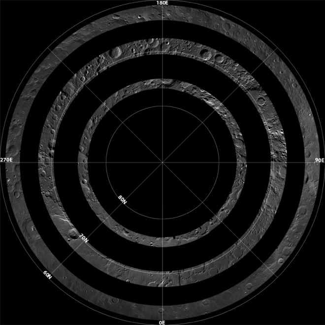
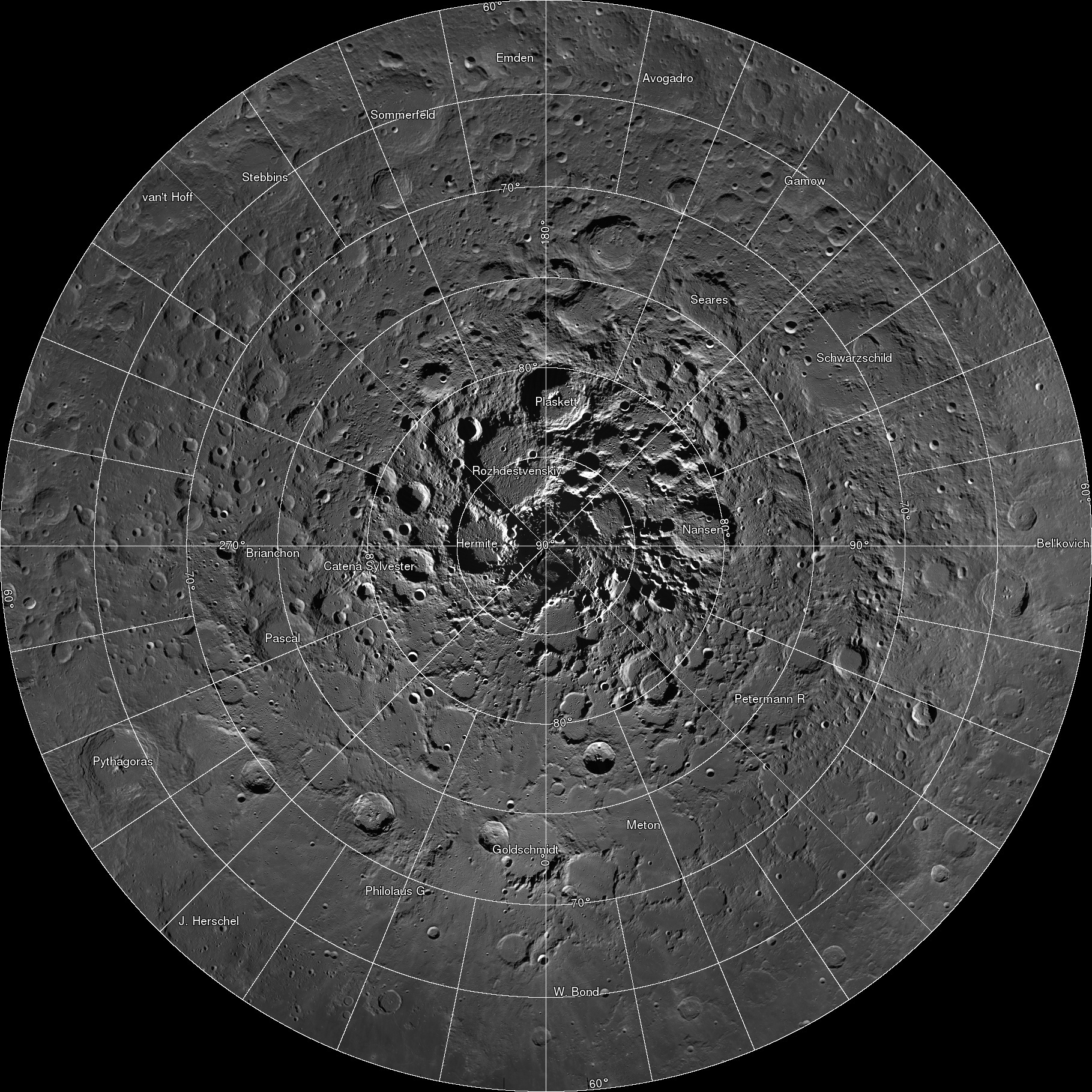
Spectacular LROC Northern Polar Mosaic (LNPM) allows exploration from 60°N up to the pole at the astounding pixel scale of 2 meters [NASA/GSFC/Arizona State University].
Mark Robinson
Principal Investigator
Lunar Reconnaissance Orbiter Camera
Arizona State University

The LROC team assembled 10,581 NAC images, collected over 4 years, into a spectacular northern polar mosaic. The LROC Northern Polar Mosaic (LNPM) is likely one of the world’s largest image mosaics in existence, or at least publicly available on the web, with over 680 gigapixels of valid image data covering a region (2.54 million km2, 0.98 million miles2) slightly larger than the combined area of Alaska (1.72 million km2) and Texas (0.70 million km2) -- at a resolution of 2 meters per pixel! To create the mosaic, each LROC NAC image was map projected on a 30 m/pixel Lunar Orbiter Laser Altimeter (LOLA) derived Digital Terrain Model (DTM) using a software package called the Integrated Software for Imagers and Spectrometers (ISIS).
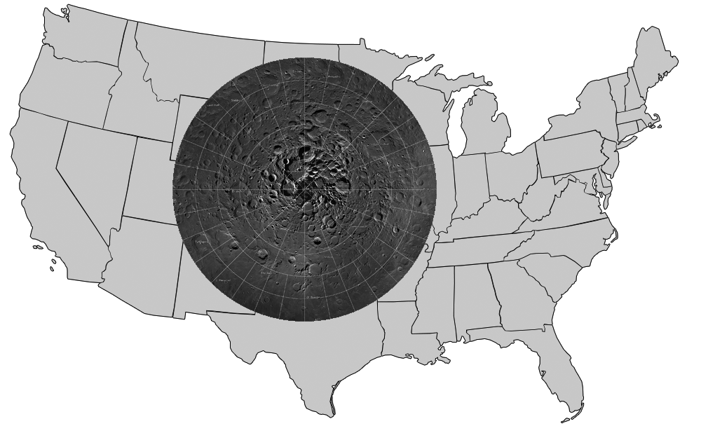
Figure 1. LNPM superposed on map of the United States.
A polar stereographic projection was used in order to limit mapping distortions when creating the 2-D map. In addition, the LROC team used improved ephemeris provide by the LOLA and GRAIL teams and an improved camera pointing model to enable accurate projection of each image in the mosaic to within 20 meters. Almost exactly 3 years ago the LROC team released a Wide Angle Camera (WAC) mosaic of the same north polar region, the pixel scale was 100 meters.

The new NAC mosaic is 50x higher resolution!
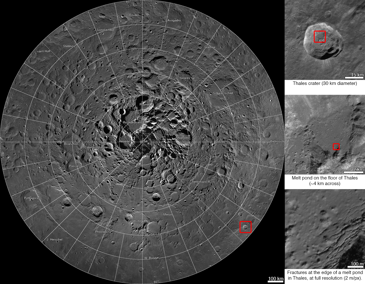
LNPM with three levels of zoom down into Thales crater [NASA/GSFC/Arizona State University].
The LNPM was assembled from individual "collar" mosaics. Each collar mosaic was acquired by imaging the same latitude once every two-hour orbit for a month during which time the rotation of the Moon steadily brought every longitude into view. Each collar mosaic has very similar lighting from start to end and covers 1° to 3° of latitude.

Three collar mosaics illustrating how the images were acquired over time to build the LNPM [NASA/GSFC/Arizona State University].
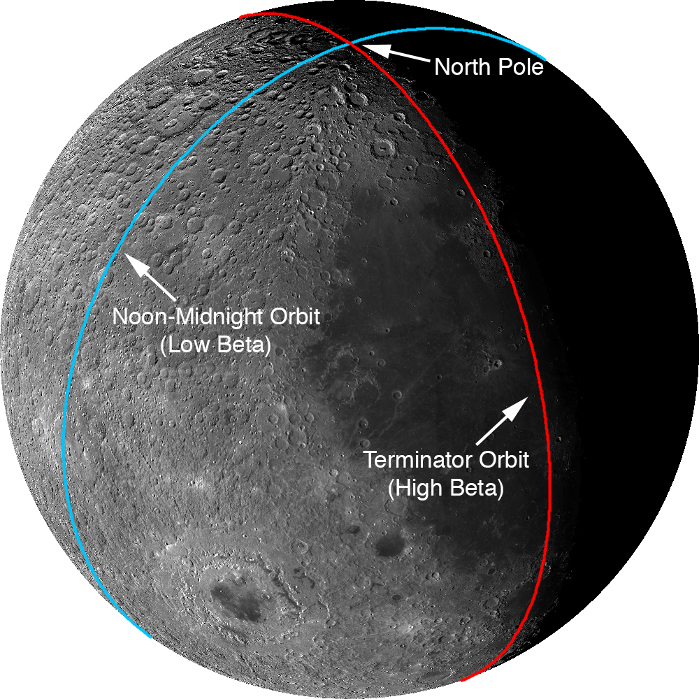
The Moon does have subtle seasons and the LRO orbit cycles between noon-midnight and terminator orbits (measured as the angle between the spacecraft orbit plane and the sub-solar longitude; known as the beta angle). Lighting at the poles is best during northern summer and when the spacecraft is in noon-midnight orbits (low beta). There are a few gaps in the collar sequences due to spacecraft anomalies and special slewed observations that point the cameras off into space. These gaps were filled with images acquired at other times in the mission. These gap-filling images sometimes have the Sun from the opposite direction of the surrounding collar, resulting in noticeable boundaries.

Two types of orbit that LRO experiences through a six-month cycle. Images acquired during terminator orbits have long shadows from the equator to the pole. For noon-midnight orbits the Sun is overhead (no shadows) at the equator and shadows, though still large, are minimized at the poles.
The LNPM was originally assembled as 841 large tiles due to the sheer volume of data: if the mosaic was processed as a single file it would have been approximately 3.3 terabytes in size! Part of the large size is due to the incredible dynamic range of the NACs. The raw images are recorded as 12-bit data (4096 grey levels) then processed to normalized reflectance (a quantitative measure of the percentage of light reflected from each spot on the ground). To preserve the subtle shading gradations of the raw images during processing the NAC images are stored as 32-bit floating-point values (millions of grey levels). The 32-bit values are four times the disk size of the finalized 8-bit (255 grey levels) representation most computers use to display greyscale images. The conversion process from 32-bit to 8-bit pixels results in saturation (group of pixels all with the maximum value of 255) in the brightest areas.

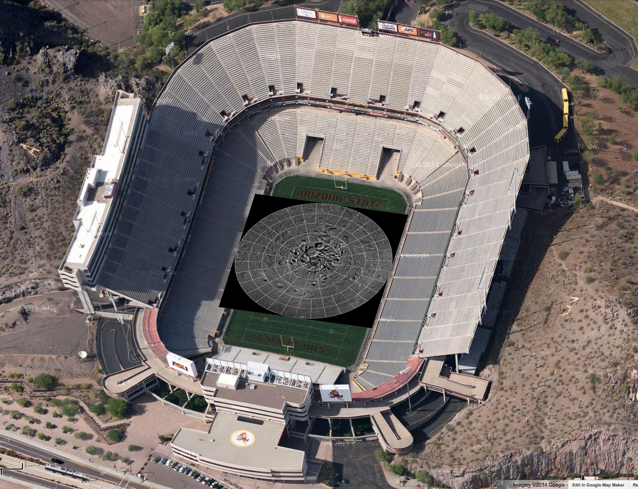
Printed at 300dpi (a high-quality printing resolution that requires you to peer very closely to distinguish pixels), the LNPM would be larger than a football field.
Even with the conversion, the compressed JPEG images that make up the final product take up almost a terabyte of disk space. To create the zooming and panning Gigapan version, multiple versions of each large tile (32,768 pixels square) were made at varying pixel scales. Next, appropriate labels and grid lines were added for each zoom level in hopes of keeping the user oriented – no sense in getting lost on the Moon! Finally these larger tiles were split into 256-pixel square images, allowing a web browser on an average network to keep up with the amazing detail (only a few tens of kilobytes are needed to see any given location at full resolution). In total the LROC NAC northern polar mosaic required 17,641,035 small tiles to produce the final product.

Dive right in HERE, and explore each of the 681 Gigapixels.

LNPM by the numbers:

Square image: 931,070 pixels across and down
Total pixels: 866,891,344,900  (867 billion)
Pixels with image data: 680,808,991,627 (681 billion)
NAC images: 10,581
Image tiles (256x256): 17,641,035 (18 million)
Mass storage of tiles: 950 Gigabytes

Acknowledgments: The LOLA team provided the high resolution topography used to map project the NAC images and improved spacecraft ephemeris that allowed accurate placement of the images on the lunar latitude longitude grid. Gigapan provided mass storage and a web interface. The United States Geological Survey Astrogeology Science Center provided the ISIS image processing software. The NASA LRO project collected the data and funded the processing effort. The LROC imaging suite was developed and built by Malin Space Science Systems (MSSS).

Tuesday, March 27, 2012

1000 Day Anniversary of LROC Imaging

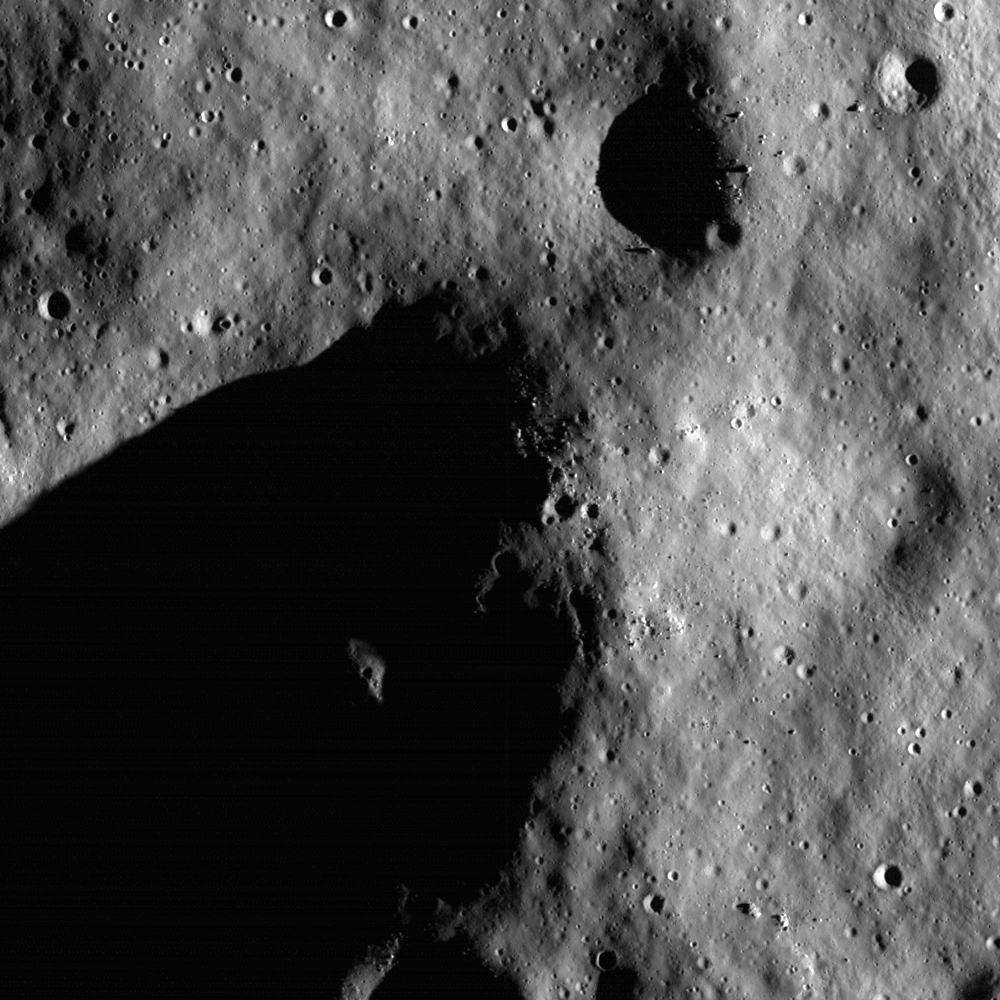
Rim of Shackleton crater near the lunar South Pole as seen in the first LROC Narrow Angle Camera (NAC) image of the Moon, acquired on June 30, 2009. Image field of view is 850 meters across, NAC frame M101013931, orbit 72, resolution 99 centimeters per pixel from 42.96 kilometers. View the full size Featured Image HERE [NASA/GSFC/Arizona State University].
Samuel Lawrence
LROC News System

Today marks the one thousand day anniversary of LROC imaging from lunar orbit. Since 30 June 2009, LROC has acquired a total of 750,000 images: of these, 140,000 are WAC images and 440,000 are NAC images of the illuminated Moon (the remainder are night or space calibration images). So far the NACs have imaged about 40% of the Moon. NAC and WAC images will play a key role defining where human and robotic explorers will go to unravel many remaining mysteries of the Moon and inner Solar System.

A look back - After the launch of LRO on 18 June 2009, Science Operations Center (SOC) operations at ASU commenced immediately, with the SOC monitoring the status of the instrument as our personnel supporting launch operations at the Cape Canaveral Air Force Station flew back to Phoenix. The first images we collected with the LROC system a few weeks later were actually engineering test images to ascertain hardware functionality, and most importantly, show how well the focusing of the NACs was proceeding. Why? Because the Narrow Angle Cameras (NAC) telescope structures were built out of carbon fiber, they absorbed atmospheric water vapor, which caused the carbon-fiber to expand. In effect, the NACs were built out-of-focus in the laboratory, with the knowledge that the water vapor would be driven out of the structure in space and thus shrink. Careful engineering by Malin Space Science Systems (MSSS) ensured that the shrinkage was just enough that the optical elements would move into position and the cameras would be in focus. Exposure to the vacuum of space and decontamination heaters built into the camera drove the moisture from the carbon fiber, thus bringing the cameras into focus in about two weeks.

The first LROC images were collected on 30 June. We started to commission the LROC instruments over the Fourth of July weekend in 2009. I think I can speak for the entire LROC team at ASU when I say that there is no better way to celebrate the Fourth of July than by commissioning an American spacecraft in lunar orbit. Working for any NASA spaceflight mission, especially one that is leading the way towards returning Americans to their rightful place on the lunar surface, is and always will be a special honor and a privilege for those fortunate enough to get the opportunity to contribute.

Lunar South Pole, on the rim of Shackleton Crater, with it's permanently shadowed interior at upper left. Press release image, September 2009 [NASA/GSFC/Arizona State University].
We were pleasantly surprised when our pre-launch estimates turned out to be a bit conservative, and our first pictures were completely in focus. I will always remember the thrill of seeing that first image come up on the screen, proving that everything we had been working on for several years was functioning. The LROC team promptly released many pictures of the lunar surface in the following few days. Today's Featured Image is a look back at our very first image of the Moon, which appropriately enough shows the rim of Shackleton crater, one of the current highest-priority sites for human exploration. Why is Shackleton so interesting? Small portions of its rim are nearly continuously illuminated while its interior is perpetually in darkness. The dark areas harbor a treasure trove of volatiles (water) that can be harvested to support future lunar explorers, provide important clues to the history of volatile materials in our Solar System, and enable voyages to Mars and beyond.

Lunar South Pole, low resolution version of first NAC pair overlaid and outlined on a WAC basemap. Note that the WAC mosaic was built up over a month, and during that time the sun azimuth reversed, resulting in an interior to exterior illumination discontinuity on the rim of Shackleton crater [NASA/GSFC/Arizona State University].
The Adventure Continues - We have since acquired other images of not only Shackleton, but many other sites on the Moon, providing the data that NASA and other space organizations worldwide require to facilitate scientific discovery, safe landing site selection, and resource assessment. In fact, we have mapped more than 40% of the lunar surface with the NACs since launch. The LRO mission is showing no signs of slowing down and LROC continues to enable new science results that are redefining our knowledge of the Moon. After entering the stable frozen orbit several months ago, LRO has enough fuel for at least another five years of operations, and our overriding goal on the LROC team is to map the whole Moon with the NACs before the end of the mission. We have mapped the Moon globally with the LROC WAC over 28 times. Each WAC global map was acquired with different lighting, thus providing a powerful multi-temporal tool to unravel the physics of light interactions with planetary surfaces.

LROC data have thus far enabled major advances in our understanding of lunar volcanism, impact processes, lunar tectonics, and the lunar environment, and the discoveries have just begun. The lunar science and exploration communities will be analyzing LROC data for decades to come.

The LROC team is proud of the work we have accomplished thus far, excited for the discoveries yet to be made, and feel privileged to contribute to America's first steps on the road back to the Moon. The LROC team at ASU is eager to make the next 1000 days of LROC operations as rewarding, exciting, and productive as the first 1000 days have been. The Moon, with its incredible bounty of exploitable resources, stunningly beautiful vistas, and incredibly compelling scientific questions, continues to beckon us towards the next horizon.

Take a look at the full frame of the first LROC NAC image of the Moon, HERE.