Showing posts with label Lunar Prospector. Show all posts

Sunday, November 30, 2014

Is there an economic case for mining the Moon?

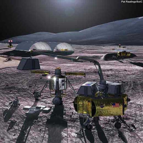
Of necessity, much of the actual work of harvesting resources for true in situ resource utilization (ISRU) will have to be done robotically [Pat Rawlings/SAIC].
Ian Crawford
Birkbeck, University of London

To date, all human economic activity has depended on the material and energy resources of a single planet; understandably, perhaps. It is conceivable though that future advances in space exploration could change this by opening our closed planetary economy to essentially unlimited external resources of energy and raw materials.

Look up at the Moon this evening, and you might be gazing at a solution. The Earth’s closest celestial neighbour seems likely to play a major role and already a number of private companies have been created to explore the possibilities.

It is important to stress that even now, 40 years after the Apollo missions, we still don’t have a complete picture of the Moon’s economic potential, and obtaining one will require a more rigorous programme of lunar exploration than has been undertaken to-date. In part, this is why proposed future lunar exploration missions (such as the recently announced Lunar Mission One) are so important.

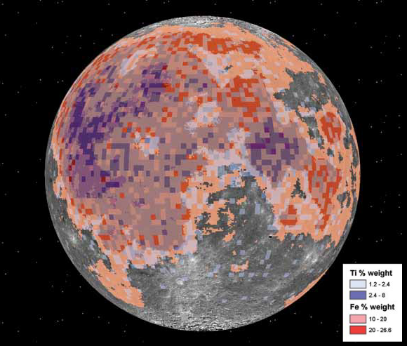
"In addition, lunar surface rocks and soils are rich in potentially useful, but heavy (and thus expensive to launch from Earth) raw materials such as magnesium, aluminium, silicon, iron and titanium." - Relative abundances of titanium and iron, as a percentage of weight, plotted against the nearside hemisphere. Note the heaviest incidences appear in the Ocean of Storms and Sea of Tranquility.
Nevertheless, as a result of work over the past four decades, we do now know enough to make a first-order assessment of lunar resource potential. In doing so it is useful to distinguish between three possible future applications of such resources.

Read the full article published at The Conversation, HERE.

NOTE from Mr. Crawford: "This essay is based on a much more detailed review article which will be published next year, and in which references to sources and more extensive discussion will be found here: arXiv.org/abs/1410.6865."

Wednesday, January 15, 2014

Hansteen α

Hansteen α (LROC NAC)
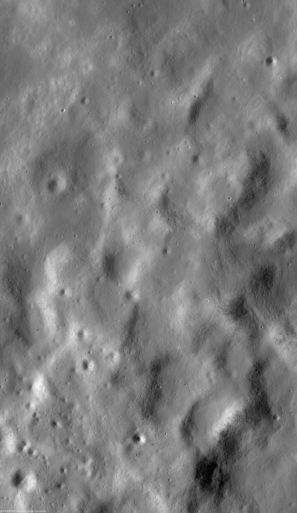
Close up on the heights (-923.8 elev.) of Hansteen α (AKA, "Mons Hansteen" and "the Arrowhead"), a triangular berg, 25 km long on its three margins, composed of intrinsically bright material and rising here 1030 meters above its neighborhood in south Oceanus Procellarum.  LROC Narrow Angle Camera (NAC) periapsis observation M166175569LR, spacecraft orbit 9623, July 24, 2011; 61.74° incidence, slew 16.45° west, resolution 0.5 meters from 41.05 km (Enlarged image HERE.) [NASA/GSFC/Arizona State University].
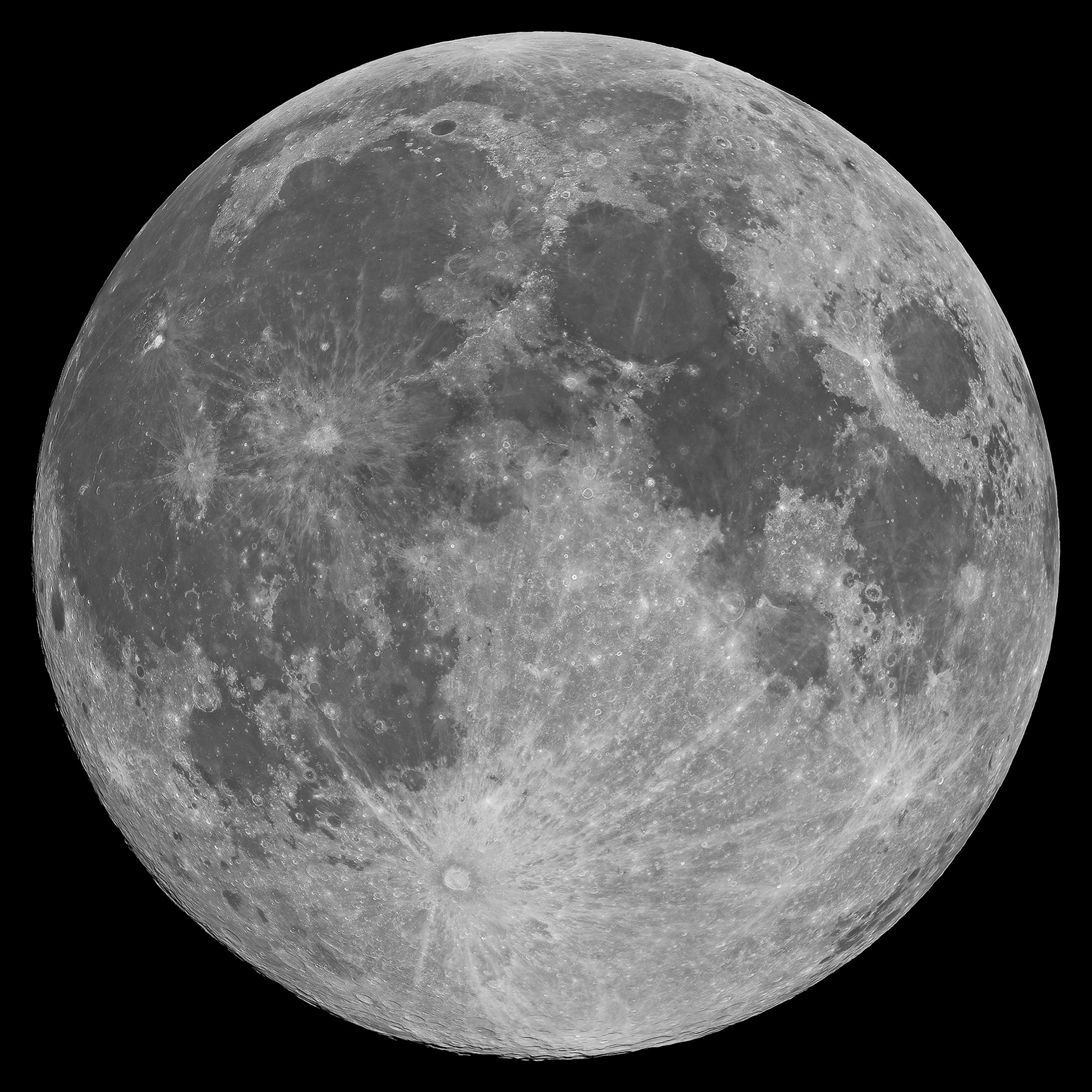
Mons Hansteen (12.2°S, 50.21°W) is a familiar nearside landmark, when viewing a Moon that's almost Full through a modest telescope. As the reader can see in the picture of the Full Moon at the end of this post, it stands out from its surroundings in the far south Oceanus Procellarum.

It's nicknamed "the arrowhead" because it looks like one, like, long-ago, it was knapped to a point by the patient hand of a hunter and now rests half buried in the darker mud of a trail, perhaps uncovered by a recent downpour.

Close investigations of the Moon over the past half century reveal what investigators call "Hansteen Alpha," or Hansteen α, stands out geologically and in other ways. The small mountain is made of different stuff than most of what is found on the lunar surface and the volcanism that flooded and re-flooded the Moon's basins. It's optical brightness is complimented by differences at other wavelengths as well, presenting a spectral profile found in only a few other locations on the Moon. 

Hansteen α is one of the Moon's red spots, bright with an albedo similar to the lunar highlands but spectrally red, brighter in shorter wavelengths and characterized by absorption in the ultra-violet (UV). 

Moreover, it must be a younger feature than it might seem on first glance, younger than certain of the larger craters nearby and other features in its neighborhood that were clearly overrun repeatedly by the darker basaltic lavas that periodically flooded and re-flooded the lower elevations over a period nearly three billion years long.

Hansteen α (LROC NAC)
The heights in the first image are at lower right in this 3.94 km-wide field of view, the full width of the area captured from LRO in LROC NAC M166175569LR, and showing a cross-section of Hansteen α from that central area north to more lower elevations, nearer the mountain's northwestern margin. (View larger sizes HERE.) [NASA/GSFC/Arizona State University].
Hansteen a (LROC WAC 250m)
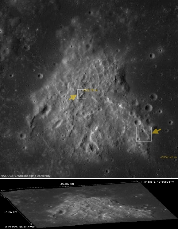
Hansteen α is younger than craters Billy (45.57 km across and 3.88 billion years old, to the south) and Hansteen (45 km across and 3.87 billion years old, to the west), because both are less than one and a half times their respective diameters in distance, and the impacts that excavated these features should have at least partially covered the bright mountain. Instead, no evidence of such a direct effect has been found, only peppering of more recent impacts. LROC Quickmap at 250 meters resolution [NASA/GSFC/Arizona State University].
Hansteen α resembles the Moon's highlands but, beginning early in the post-Apollo era, investigators noted differences in texture, color and measured albedo. In the close-ups at the beginning of this post, showing some of the highest elevations of Hansteen α, depressions can be seen clustered on terraces. These seem to have once been volcanic vents.  Volcanic vents are not particularly rare on the Moon, but the kind of material that emerged from these is clearly not the same stuff that flooded its surroundings.

LROCQM064-H-a-580x746
A closer look at Hansteen α elevations, with locations marked of areas shown in LROC NAC observations posted here, the highest elevations and, further along along, some solidified flows on the steep southeastern margin, included below. LROC Quickmap at 64 meters resolution, together with the LROC WAC-derived digital terrain model [NASA/GSFC/Arizona State University].
Using an experimental 3D visualization tool, accessed through the LROC Quickmap. a 152 square km area, centered on Hansteen α, animated between 0 and 10 X vertical exaggeration, further illustrating highest elevations, southwest of the formation's center; something more difficult to measure using 2D overhead photography [NASA/GSFC/Arizona State University].
The margins of Hansteen α seem abrupt, with steeper slopes than is found around the edges of the more common basaltic domes. This might be in keeping with suggestions that the kind of lava emerging into and out of this feature was thicker, related to its composition and the heat necessary for melting and transport. It also provides geologists with clues about its age relative to the volcanism that flooded Procellarum in this region.  

The Hansteen α might have formed from a "secondary," and "more evolved" volcanism, something certainly less common than the basaltic lavas that flowed out into the Moon's broad basins, not once but repeatedly, over a 2.7 billion year period, from the Nectarian age, when the Moon and Earth were only 600 million years old, until just prior to the Copernican period 1.2 billion years ago.

These more recent high-resolution images from LRO show groupings of blocky boulders, mostly related to mass wasting along slopes though some of these clusters are found on level areas and don't appear to be the result of impacts.

Intrusive volcanism Hansteen Alpha
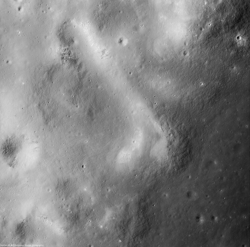
An intrusive flow, clearly visible on the abrupt southeastern margin of Hansteen alpha,  right where it solidified, This is a 3.93 km square field of view from LROC NAC observation M1129816872R, orbit 18636, July 30, 2013; 42.35° incidence, 80 cm per pixel resolution from 80.7 km over 12.2°S, 310.14°E  [NASA/GSFC/Arizona State University].
Intrusive volcanism Hansteen Alpha
Contextual view of the full 7.8 km-wide field of view swept up in the same LROC NAC  observation, showing a wider view of southeast margin of Hansteen α. Such close-ups reveal that the margin here is more abrupt than it seems at a distance. (Enlarged views and various other sizes available HERE.) [NASA/GSFC/Arizona State University].
So, just what is Hansteen alpha? In two papers presented in 2011 and 2012 to the Lunar and Planetary Science Conference, Hawke, et.al., representing some of the more noted investigators working with data returned from LRO (the more recent of these being  "The Geology and Composition of Hansteen Alpha," 43rd Lunar and Planetary Science Conference (2012), #1754), wrote, "Non-mare volcanism is the only viable process for the formation of Hansteen α."

That paper, along with others those investigators cite, along with still others cited as references below, present truly fascinating discussion of how instruments on-board Clementine (1994), Lunar Prospector (1998-99) and both the LROC cameras and the Diviner instrument, flying on LRO since 2009, are actively being used to weed out the history of this unique feature and how it relates to the complicated volcanic stratigraphy of the Procellarum basin.

Finding Hansteen alpha (Mons Hansteen)
Finding Hansteen α through a modest telescope is relatively easy, from about four days after First Quarter through three days after Last Quarter, on the south edge of Oceanus Procellarum, as shown in this well-crafted mosaic by Stephan Lammel. Look for it left of center in the inset and in the Full Moon, above.
References:

Related ASU LROC Posts:
The Fourth Marian Dome (April 17, 2013)
Aristarchus Spectacular! (December 26, 2011)
Silicic volcanism on the Moon (February 14, 2011)

Monday, June 3, 2013

GSFC releases LEND lunar water demonstration

Map of energetic neutron absorption near the lunar South Pole, showing the places where water ice is most likely to be found, built up and trapped for aeons in areas of extreme cold and darkness. Interestingly, not all the permanently shadowed regions show strong detection of hydrogen atoms while some areas that do receive at least some sunshine do register such a presence. Note the strong indication at Cabeus, chosen late in the LCROSS mission as its impact target in 2009. [NASA/GSFC/SVS/Roscosmos].
NASA has released a new video, prepared by the Science Visualization Studio (SVS) at Goddard, highlighting the Lunar Exploration Neutron Detector (LEND) and results of data that instrument has built up since it arrived in orbit with the Lunar Reconnaissance Orbiter (LRO) three years ago.

The new SVS video is a popular introduction the role of LEND as part of the LRO mission, not a comprehensive report of results except to show how data was methodically collected over many months in polar orbit.

Though not without some controversy, regarding its resolution and final value, the Russian LEND - a highly anticipated follow-up to Lunar Prospector (1998-1999) - has now orbited over the Moon's north and south poles 18,000 times. The instrument has measured absorption of neutrons scattered from the surface below, indicating the possible presence of water ice or other volatile hydrogen compounds at the Moon's high latitudes.

The press release discussion of the new LEND video reads, "Since the 1960's, scientists have suspected that frozen water could survive in cold, dark craters at the Moon's poles. While previous lunar missions have detected hints of water on the Moon, new data from the Lunar Reconnaissance Orbiter (LRO) pinpoints areas near the south pole where water is likely to exist. The key to this discovery is hydrogen, the main ingredient in water: LRO uses its Lunar Exploration Neutron Detector, or LEND, to measure how much hydrogen is trapped within the lunar soil. By combining years of LEND data, scientists see mounting evidence of hydrogen-rich areas near the Moon's south pole, strongly suggesting the presence of frozen water." 

Related Posts:
LRO LEND: "A Scientific Dispute" (March 27, 2012)
Will LRO LEND prove effective? (February 21, 2012)
Where are the wettest places on the Moon (October 23, 2010)
LRO analysis of LCROSS impact proves essential (October 21, 2010)

Saturday, January 5, 2013

The Radiation environment and its effect on human spaceflight: A Lunar Mission

Relative monthly infall of galactic cosmic rays from 1958 through December 2012 shows the inverse relationship with solar activity. The highest GCR infall rate (since the beginning of the Space Age) was recorded in late 2009 (arrow), occurring at the same time was the latest and unusually lengthy solar minimum [Moscow Neutron Monitor].
João Sabino
Instituto Superior Técnico
Lisboa, Portugal

This work is an overview of the quantities and concepts common in radiation physics and describes the types of radiation important to planning crewed missions to the Moon. Radiation effects on biological tissue and the consequences to astronaut health are addressed.

The environment of a mission to the Moon was simulated based on data obtained with the CREME program along with data from Lunar Prospector neutron measurements. The virtual mission was divided into stages of a trajectory: Low Earth Orbit, traversing the Van Allen Radiation Belts (VARB), the geostationary orbit radiation environment (GEO), lunar orbit and surface radiation environments. 

Major details in the development of a software application in Geant4 (CERN) are presented. The application was used to reproduce the transport of radiation particles through matter, to simulate the physics involved and to obtain the resulting absorbed dose, equivalent dose and the spectre of secondary radiation. The quantities were evaluated for solar minimum, solar maximum, and solar conditions wre evaluated for each mission phase.

The radiation environment in the solar system presents the main constraint to human spaceflight outside Earth's protecting radiation belts.

As the human presence in space tends to increase, or the will to reach other planets grows, radiation in space becomes a more compelling obstacle that needs to be dealt with. The risks that radiation exposure presents to space missions directly effects mission planing. For this reason a good knowledge of the radiation environment in all mission phases is essential. Development of reliable prediction tools is of major importance to assist mission planing and assure minimum safety for the crew.

This work pretends to explain subjects that need to be taken into account to understand problems space radiation pose to human spaceflight, taking as an example the case of a real lunar mission scenario and also documenting the development of software simulating the radiation environment and analyzing the effects of exposure.

Robotic space exploration looks promising in the immediate future, but despite huge advantages many scientists acknowledge it is not sufficient alone, that humans are needed in space to perform more complex research tasks such as field geology and the acquisition and analysis of samples.

This is a strong incentive towards human spaceflight and also a natural drive based on curiosity and adventure the human being has shown in this kind of challenge that lead us to go farther and farther; not to mention technological and industrial advancements always associated with meeting such challenges. Nowdays, even the tourism industry has begun to recognize space as an interesting destination for the wealthy, and some companies have already flown tourists to the International Space Station.

Human space exploration beyond LEO is presumably going to reemerge very soon, especially if some of the present risk it poses are minimized.

Download or read the study (pdf), HERE.

Cosmic ray flux effects lunar ice (March 19, 2012)
a perfect storm of cosmic rays” (September 29, 2009)
Cosmic rays and manned space travel (September 16, 2009)
Cosmic ray flux highest ever recorded (September 3, 2009)
LUNAR-TEX radiation blanket: Skeptical (May 11, 2009)

Managing Space Radiation Risk in the New Era of Space Exploration (2008)
Committee on the Evaluation of Radiation Shielding for Space Exploration
National Research Council

Friday, June 1, 2012

Who discovered water on the Moon?

Wishing well? The last direct lunar sample was retrieved by the Soviet Luna 24 robotic lander, August 18, 1976. In total darkness, the descent stage landed on rim of this 64 meter crater, on the southeastern volcanic plains of Mare Crisium (12.717°N, 62.222°E), where it was imaged by the LROC Narrow Angle Camera last fall. Enlargement of lander at lower left, LROC NAC observation M174868307L, LRO orbit 10904, November 2, 2011; resolution 43 cm per pixel from 25.57 kilometers [NASA/GSFC/Arizona State University].
Paul D. Spudis
The Once and Future Moon
Smithsonian Air & Space
< /br>
A recent article tells how Soviet scientists studying regolith samples returned from the Moon in 1976 by the unmanned Luna 24 mission first discovered lunar water.  This assertion is based on a paper published in the Russian journal Geokhimiia (vol. 285, p. 285-288, February 1978).  The measurement used infrared absorption spectroscopy to look for the “water band” centered around 2.8 microns, the same technique used recently by several groups to map the water band on the lunar surface regionally from flyby (Cassini and EPOXI) and orbital (Chandrayaan-1) spacecraft.  The Soviet paper claimed to detect water at a level of about 0.1 weight percent.  This high concentration level of water raised my antennae.

The discovery of significant amounts of water would tell us about lunar processes and history as well as provide evidence that water might be manufactured on the Moon to support future exploration.  The first lunar samples returned to Earth in 1969 by the Apollo 11 mission were intensely scrutinized for water content.  Besides being exceedingly dry, the chemistry of the Apollo samples suggested they were created in a completely anhydrous, reducing environment.  Samples from subsequent missions confirmed and extended this initial impression to the point where talk of water on the Moon was mostly dismissed.

A rock returned in 1972 by the Apollo 16 mission displayed visible brownish splotches which turned out to be “rust” in the form of the mineral akaganeite, an iron-hydroxyl phase, with minor amounts of chlorine.  This mineral could have formed by the aqueous alteration of the iron-chlorine mineral lawrencite found in some meteorites.  However a source of water is still needed to create the “rust,” so for several years the source of the water and the nature of the alteration were debated.  Did water come from the inside of the Moon or from an impacting comet?  Did the oxidation occur on the Moon or was it caused by the exposure of the highly reduced lunar sample to humid air (from inside the returning Apollo command module or the Houston summer humidity)?  Different workers had a variety of opinions but with no resolution, interest faded.

But a few inquisitive types didn’t forget it.  Jim Arnold, a chemist from UC-San Diego, resurrected an old idea about permanent cold and dark areas near the lunar poles.  He concluded that over the course of history these areas were cold enough and old enough to have accumulated significant amounts of water from meteorites and comets.  Groups studying the regolith from the Apollo missions measured variable amounts of hydrogen on dust grains; when heated, hydrogen in that dust reacted with metal oxides in the soil producing native metal (iron) and water vapor.  Although done in the laboratory, it was shown that the process could occur naturally on the Moon during the impact of a micrometeorite, whose energy is mostly dissipated as heat.  This heat and the hydrogen on dust grains could “reduce” the material, creating measurable water release.

During the lunar “wilderness years” (i.e., 1976-1994, when no one was going to the Moon) all we could do was speculate and analyze existing samples.  In 1982 a meteorite from the Moon was discovered in Antarctica.  Lunar meteorites provided a new source of samples but even though all had significant exposure to the terrestrial hydrosphere, none of them showed evidence for water-bearing phases.  Attempts were made to map the poles of the Moon from Earth using optical and radar telescopes but poor viewing geometry led to uncertain conclusions.

Two events re-ignited the water debate.  The 1994 Clementine spacecraft probed the south pole of the Moon and found evidence for coherent backscatter near the dark areas.  The team interpreted this as indicating the presence of water ice.  Following Clementine, the Lunar Prospector (1998-1999) neutron detector found elevated amounts of hydrogen near both poles of the Moon, resulting in new interest about the possibilities for water on the Moon.  In recent years, a variety of robotic missions, carrying instruments designed to address the lunar water question one way or another, found large amounts of water in a variety of different forms, locations and concentrations.  We are just beginning to decipher the origins, cycles, and eventual fate of this water.

So what can we say about the Soviet results published in 1978?  No other scientist or group has repeated this measurement on the Luna 24 samples to confirm its validity.  Under a reciprocal exchange agreement with the Soviet Union in the late 1970s, others studied the Luna 24 samples but none reported any traces of water in their samples.  No one in Russia has studied the Luna 24 samples in years (at least to my knowledge), although they still exist and presumably are available for analysis.  The spectral detection of water in the Luna 24 sample should be repeated and then followed up with analyses by other techniques to confirm the water’s presence and to cross-check the amounts claimed.  The published value of 0.1 weight percent (1000 part per million) water seems very high for lunar regolith from equatorial and mid-latitudes; typically, such material contains 10-50 ppm hydrogen, almost two orders of magnitude less than the 1978 reported result.  Finally, even if the old analysis is confirmed, questions about its source are still pertinent; we are still arguing about the origin of the water that made the rust in “Rusty Rock.”

If you’ve stayed with me this far, I hope that if nothing else, this brief history of a lunar controversy has shown that it is difficult (I would say impossible) to assign “credit” to any one paper or worker or group for the discovery of water on the Moon.  In science we always proceed from the knowledge gained by previous work.  Sir Isaac Newton put it well when he famously said that he saw more clearly because he stood on the shoulders of giants.  A lunar scientist’s goal is to study, document and explain, thereby contributing to and advancing our knowledge and understanding of the Moon.

Originally published at his Smithsonian Air & Space blog The Once and Future Moon, Dr. Spudis is a senior staff scientist at the Lunar and Planetary Institute. The opinions expressed are those of the author and are better informed than average.

Tuesday, July 26, 2011

LROC: Farside Highlands volcanism


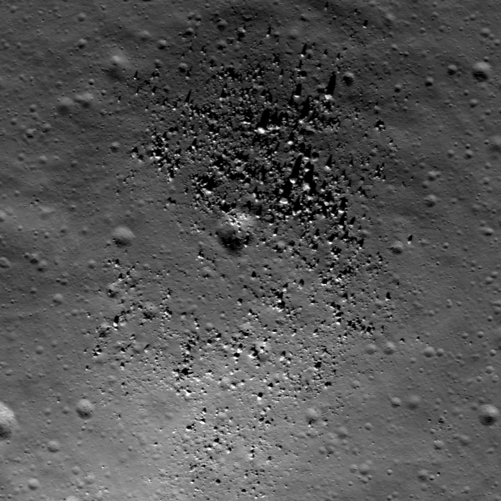
Small dome in the Compton-Belkovich "Thorium Anomaly" region (61.33 °N, 99.68 °E). Evidence indicates a volcanic origin for this and other intriguing features in this relatively small area in the highlands of the lunar farside's northern hemisphere. Solar illumination Incidence Angle is 64°, Sun is from the SSW, field of view roughly 510 meters. LROC Narrow Angle Camera (NAC) observation M139238146L, LRO orbit 5653, September 16, 2010. See the full-size LROC Featured Image HERE [NASA/GSFC/Arizona State University].


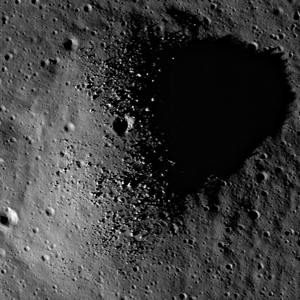
Same dome, early evening shadow, brings out small topographic features in relief. Note in the close-up view in the image following below the summit boulder shadows. Full frame field of view above is roughly 3100 meters across; LROC NAC observation M119198897L, LRO orbit 2700, January 27, 2010 [NASA/GSFC/Arizona State University].

Mark Robinson
Principle Investigator
Lunar Reconnaissance Orbiter Camera
Arizona State University

Since the domes in the Compton-Belkovich area are rounded and smooth (excepting the boulders scattered across the summit) they are not easy to spot. At sunrise and sunset (above) even smooth topography casts long shadows. In this case the Sun is 13° degrees above the horizon, showing that the slopes of the dome are steeper than 13°, an important clue to unraveling its origin. Steeper slopes often mean more viscous magma, which in turn points toward more silica rich compositions.


Full-resolution close-up of Compton-Belkovich "Dome-1" from M119198897L and the early evening shadow brings the meter-sized boulders into view [NASA/GSFC/Arizona State University].

Are you having trouble seeing the feature as a dome, that is, with positive relief? Consider the above subsampled images above from M119198897L and the wider view that includes a small crater just east of the dome. The sun is from the left. Sometimes your brain can be fooled - you see what is up as what is down. If you know the Sun direction you can "force" the ups to become downs, and vice versa. And what about the little crater at the top of the dome? Is it a volcanic vent or an impact crater? If you said “impact crater” – you are right! The top of the dome is actually about 100 m south of the small crater. The crater just happens to be near the top of the dome.


LROC Wide Angle Camera (WAC) observation M119212328M, LRO orbit 2702, January 27, 2010, and a rare example of "non-mare" silicic volcanism situated between Compton and Belkovich craters on the lunar farside, the "Compton-Belkovich High-Reflectance Feature." For scale, the small dome (and it's companion crater to the east) are indicated by the yellow arrow [NASA/GSFC/Arizona State University].


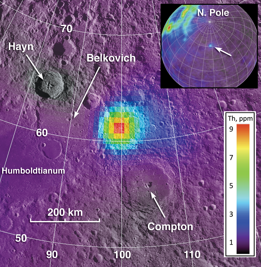
Composite image showing geochemistry from Lunar Prospector and the spike in thorium coincident with the CBHRF. (Note the nearside-farside differences in thorium seen in the inset) View the full-size context composite illustration HERE [Jolliff et al, 2011].

The Compton-Belkovich site was of special interest even before the LRO mission began. Back in 1998 the Lunar Prospector spacecraft, with its gamma-ray spectrometer, measured the global distribution of the element thorium, which has a strong peak in the gamma-ray spectrum because it is naturally radioactive. Although much of the Moon’s thorium, at least as expressed on the surface, lies mostly on the nearside, a terrain between the craters Compton and Belkovich lit up like a bull’s eye (above). For this reason, the site was selected as one of NASA’s Project Constellation sites because it is of high interest for future human or robotic exploration.


Figure 3 from "Non-Mare, Silicic Volcanism on the Moon's Far Side," Jolliff, et al., Lunar & Planetary Science Conference 2011, #2224.

This thorium “hot spot” was described by David Lawrence and the Lunar Prospector gamma-ray spectrometer team (see figure), later Jeff Gillis and coworkers noted in looking at Clementine images that a high albedo feature was located near the center of the thorium bull’s eye (see WAC context image above). However, since then, the origin of the hot spot and the nature of the deposits was not known until LRO imaged the site with the LROC Narrow Angle Cameras. Those images revealed numerous volcanic features, some large, and some small, like the little dome seen in today’s featured image. Between the Lunar Prospector and Diviner geochemistry and the LROC images, we are able to determine that these domes are examples of silicic (rich in silica relative to basalt) volcanism. An amazing discovery - the only silicic volcanism on the farside.

Be sure to return and read future posts about other features in this intriguing and unusual volcanic terrain on the Moon. What a fabulous place this would be for astronaut geologists to explore, do field geology, and collect samples for analysis!

In the meantime explore the full resolution NAC and see what volcanic features you can find!

Saturday, October 23, 2010

Where are the wettest places on the Moon


High resolution (~15 km) polar maps of collimated epithermal neutrons created by the LRO Lunar Exploration Neutron Detector (LEND) team. The permanently shadowed region at Cabeus shows an indication of 4% hydrogen (by weight), while the Shoemaker crater neutron suppression signature, entirely within a widespread PSR, shows a signature consistent with 2%. Note that the crater Faustini, similarly situated and permanently shadowed, shows a very average polar neutron suppression. The reason for this disparity is not yet known.

The Lunar Exploration Neutron Detector (LEND) flying with LRO has enabled investigators to create high-resolution (15) km) maps of the collimated epithermal neutron counting rate over the lunar poles.

Overlapping these data upon new and improved maps of the Moon's confirmed permanently shadowed regions (PSRs) there has proven puzzling. Though the neutron suppression maps from Lunar Prospector had already strongly hinted that hydrogen, most likely in the form of water ice, might be more widespread - outside - permanent shadow - than cold trap placement models yet suggested, many attributed this to the low resolution of the 1999 neutron instrument.

Now LEND has identified several of what are being called "Neutron Suppression Regions," using only neutron measurement data, and the result has been what are now three types of NSRs. There are NSR's "well-correlated" with a PSR, NSRs well-correlated with a part of a PSR that nevertheless stretch well outside the shadows into areas illuminated by the Sun. Finally, there are NSRs not correlated with any large PSR. In fact, taken in all, there are as many areas typified by neutron suppression outside permanent shadow as inside.

The picture developing of the new lunar hydrology, a daily cycle and the volatiles (and now additionally a surprising variety of exotic elements and compounds) stuck within polar cold-traps is has led to yet another rediscovery of the Moon.

Below are links to the slide presentations (pdf) that accompanied the LEND team's reports about their findings made to the Annual Lunar Exploration Analysis Group (LEAG) Conference on September 16, 2010:

Main Results from LEND Instrument After One Year of Lunar Mapping Onboard NASA’s LRO
Mitrofanov, Litvak & Sanin, et.al.

Which Spot on the Moon has the Highest content of Hydrogen?
Sanin, Mitrofanov & Litvak, et.al.

Much of the Hydrogen Enrichment near the Lunar South Polar is Outside the Permanently Shadowed Regions
Boynton, Mitrofanov & Sanin, et.al.


LRO laser altimetry (LOLA) together with neutron suppression measurements (LEND) are combined to show the 72 sq. km permanently shadowed region targeted by LCROSS is not the only contiguous area there where a neutron suppression consistent with the hydrogen (in the form of water) has been detected. Areas outside the white boundary are regularly illuminated by the Sun. (Larger view, HERE) [NASA/LOLA/LEND].

Tuesday, August 31, 2010

A review of all things Schrödinger

We end August with a long-running mystery: Why has the LRO LOLA "Image of the Week" not been updated since the middle of July? One answer may be that the LOLA topography of Schrödinger basin flagged on NASA center websites served as a reminder to complete the exacting new synergistic geological map of the far south, far side basin, released Monday, August 30:


Geologic map of Schrödinger basin, which formed when a huge object struck the moon, reveals a patchwork of lunar material, including the peak ring (inner brown ring), recent volcanic activity (red), cratering (yellow) and plains material (dark green and kelly green) [NASA/Scott Mest]." >Massive Image > Sensible Image

Elizabeth Zubritsky
NASA GSFC

Schrödinger is located near the moon's south pole, a region where pockets of permanent ice are thought to exist. The map will help researchers understand lunar geologic history and identify suitable landing sites for future exploration. Scott Mest, a research scientist with the Planetary Science Institute working at NASA's Goddard Space Flight Center in Greenbelt, Md., and his colleagues created this geologic map -- the most detailed one to date -- by combining topographic data from the Lunar Orbiter Laser Altimeter, a Goddard instrument aboard the 2009 Lunar Reconnaissance Orbiter, with images and spectral data from the earlier Clementine and Lunar Prospector missions.

From August 31, 2010 -
Detail from the Schrödinger basin geologic map released by NASA GSFC, August 31, 2010 highlighting the roughly 10 x 20 kilometer area of the eastern interior occupied by the intriguing pyroclastic formation. [NASA/GSFC/Scott Mest].

Schrödinger is an example of an intriguing type of basin called a peak-ring. Like the basin rim (brown outer ring), the smaller and more fragmented peak ring (brown inner ring) is a mountainous region of crust that rose up after a huge object, probably measuring 35-40 kilometers, or about 21-25 miles, smacked into the moon here. These areas of raised crust are the oldest rocks in the basin and just about the only material that wasn't melted by the heat from the object's impact. The melted material was spewed in all directions and formed the plains. Patches of plains material can have slightly different textures and albedo (indicated by dark green and kelly green), probably because they cooled at different times. Fractures (black lines) formed in the basin floor as the material cooled.


The Clementine image of the Schrödinger basin with geological map (2010). The three landing sites and corresponding 10 km EVA radius (20 km return trip) are outlined in white. The yellow numbers correspond to following scientific points of interest: 1 – Schrödinger’s melt sheet, 2 – Schrödinger’s inner ring, 3 – basaltic units, 4 – explosive volcanic unit, 5 – deep crustal fractures, 6 – ghost craters, 7 – secondary craters, 8 – ridged terrain. - From Kohout, O’Sullivan & Kring, et.al., Scientific Opportunities for Human Exploration of the Moon’s Schrödinger Basin [LPSC 2009 #1572] The Schrödinger Basin provides a diverse suite of scientific opportunities because of the superposition of several geologic processes and because of its relatively young age. Three possible landing sites were evaluated for human exploration.

Schrödinger Basin is one of the few areas near the moon's south pole with evidence of recent volcanic activity. This includes lava flows from volcanic activity on the surface (beige areas) as well as explosive eruptions from a vent inside the red area; this vent has brought up dark material that mantles the plains (red area, which is newer than the beige regions). Older volcanic material is spread over a wider range (gray and lime green). More recent cratering by smaller objects has scattered material (yellow areas) near the top of the basin. Next to that (very light green beside yellow) is a region with a knobby texture that suggests loose material that could have come from cratering outside the basin or from a landslide on the basin's rim.

From July 16, 2010 -
LOLA Image of the Week (since July 16, 2010) Schrödinger (centered -75.0˚, 132.4˚ E), "located on the lunar far side and within South Pole-Aitken Basin, is not visible from the Earth. Crater counts suggest that the basin is less than one billion years old, making it the second youngest impact basin on the Moon (the youngest being Orientale)."

From April 23, 2010 -
Mosaic of Clementine UVVIS images (750-nm band) of the Schrödinger Basin (312 km diameter). In addition to the prominent, dark, cone-shaped feature (white arrow), Schrödinger has an inner ring of mountains partially encircling the basin floor (a ‘peak ring complex’) and a network of radial and concentric fractures. The cone is a likely volcanic vent situated on a north- east trending floor fracture, and it has a 4.5 km x 8.6 km vent surrounded by dark, explosively emplaced or pyroclastic material and a low rim. The Schrödinger volcanic vent is one of the most distinctive single-vent cones observed on the Moon and resembles ‘dark halo craters’ like those on the floor of Alphonsus. (Projection is polar stereographic, centered on the basin at -75.0°S, 132.0°E) [NASA/DOD/USGS/ASU].

From April 23, 2010 -
LROC Narrow-Angle Camera (NAC) closeup of clustered craters on the lip of the Schrödinger pyroclastic cone, a Constellation Region of Interest (ROI). Although believed to be relatively young, these craters have a subdued appearance, a texture smoothed by micrometeor 'gardening' typical of older lunar surfaces) because they formed in loose pyroclastic material. LROC NAC Frame M108313384R, this view is 785 meters across [NASA/GSFC/Arizona State University].
"A particularly interesting and unusual feature was imaged by Mini-SAR almost by accident. Because of a timing error, we started a few mapping passes of the south pole early, before the scheduled start at 80° south latitude. Good thing we did! We covered the fresh, spectacular Schrödinger impact basin, on the lunar far side. Schrödinger shows an unusual, keyhole-shaped crater along a long fissure on the basin floor. This crater is surrounded by optically dark material, which has been interpreted as volcanic ash deposits. The new Mini-SAR image shows that this material is also dark in radar reflectivity, exactly what would be expected from a fine-grained, block-free deposit. Thus, our radar images confirm the geological interpretation first derived in 1994 from Clementine images."

- Paul Spudis
Smithsonian Air & Space
March 29, 2009
From February 21, 2008 -
Kaguya (SELENE-1) multi-band imager (MI) compositional and morphological study of the Schrödinger pyroclastic formation (75.3°S, 139.1°E) [JAXA/SELENE].


Clementine (1994) and Kaguya (2008-2009). Ultra-Violet & Visible light (750-nm) UVVIS image of Schrödinger basin. b) Schrödinger DMD image taken by SELENE MI 750 nm band. c) MI 1000 nm/1050 nm absorption depth ratio from 0.8 to 1.2. From Kobayashi & Ohtake, et.al., Estimating Composition of Dark Mantle Deposit in Schrödinger Basin Using SELENE Spectral Data [LPSC 2009 #1636] Dark Mantle Deposit (DMD) regions are considered to contain glassy or crystallized pyroclastic beads. We used the spectrum data acquired by SELENE Multi-band Imager to analyze a DMD in Schrödinger basin, and estimated the composition of the DMD.

From April 23, 2010 -
Moving north (top) in a polar orbit, Japan's Kaguya took extensive HDTV of the lunar far side, including this still showing the Schrödinger Basin interior. The low and relatively darker profile of the pyroclastic dome encircling the vent is right (east) of the image center [JAXA/SELENE].

From August 31, 2010 -
Earlier Kaguya (SELENE-1) image of the eastern interior of 312 km-wide Schrödinger. The subtle differences in geologic compositions are visible, in this very-close to true-color view from 2008, though in late morning illumination the darker Schrödinger pyroclastic formation (upper center right) is an unmistakable contrast with its surroundings, in color and cratering. [JAXA/NHK/SELENE].

Finally, with sincere appreciation for all the tireless efforts underway keeping the LRO mission working and healthy, in the words of the LROC team, we urge you not to hesitate to "explore the Schrödinger Constellation region of interest for yourself!"

Friday, January 8, 2010

Moon's perfume comes from our Sun

Map of moderated neutrons over the whole Moon. Lunar Prospector data. [Elemental content from 0 to 500 keV neutrons: Lunar Prospector results, Genetay et al. / Planetary and Space Science 51 (2003) 271 – 280].

A lot has happened, suddenly it seems, since the $60 million Lunar Prospector mission first mapped fast and slow neutrons reflecting off the Moon in 1998. Five years after the small, optically blind spacecraft was deorbited into Shoemaker crater, in permanent darkness near the lunar South Pole in a forlorn last-minute attempt to accomplish what LCROSS eventually would do a decade later.

By late 2009, scientists around the world had put one and one and one together, beginning with the Russian-built neutron detector aboard Lunar Prospector in 1998, data originally thought erroneous that was detected during a sling-shot maneuver accelerating Cassini on its way to Saturn with more pieces of the puzzle collected by India's lunar orbiter Chandrayaan-1. Among other things, sniffing the Moon has shown us the Moon is wet in more ways than one, wettest in its Permanently darkened Cold Spots and at the equator. It's becoming more and more clear that the dusty, radioactive lunar exosphere is a very dynamic place.

The STEREO solar satellites only very recently confirmed the presence of neutral hydrogen in the solar wind, so the driving force behind 99 percent of the Moon's most dynamic processes and its volatiles is none other than our modest yellow dwarf Home Star. The heavier elements patiently pile up perhaps mostly from bombardment by far more energetic cosmic rays.

Put more simply, Larry O'Hanlon of Discovery News has called our remote sensing a sniffing of the Moon's solar-driven perfume, in this case calling attention to yet another player in this drama and an experiment early on in the mission of Japan's lunar orbiter Kaguya, monitoring radio signals to and from it's two sub-satellites as they rose into line-of-sight up over the horizon in 2007 and 2008.

The moon's whiff of an atmosphere has been sniffed by a Japanese spacecraft under very special conditions and confirmed as coming largely from sunlight brutally hammering the lunar surface.

Using the very first direct measurements of the moon's "exosphere" as the moon passed through the streaming tail of Earth's protective magnetic field, researchers were able to watch the short-lived and ever-changing exosphere in the absence of the hot, magnetized solar wind.

What they found confirmed that it's really just powerful ultraviolet light knocking beat-up atoms, or ions, off the lunar surface and manufacturing the bulk of the weak lunar perfume.

This discovery is important for several reasons, explains NASA lunar scientist Menelaos Sarantos. One is that it could help interpret what kinds of minerals are on the moon's surface.

"What comes out [as exosphere] more or less tells you the mineralogy of the surface," Sarantos said.

The ions and how they change over time also provide direct evidence of how much of a beating the lunar surface is taking, which is invaluable information for anyone hoping to house humans on the moon in the future.

"If you want to build a lunar base or put humans on the surface for any time," Sarantos said, "you want a well-defined radiation environment."

Read the Discovery News feature HERE.

Tuesday, December 8, 2009

PSI's Feldman 'delighted' LCROSS confirms Lunar Prospector findings

When the LCROSS rocket stage slammed into Cabeus October 9, creating an impact plume of material possibly not seen in sunlight for billions of years, it conclusively proved that water ice exists in the dark recesses of the moon's polar craters.

The LCROSS findings delighted William Feldman, a senior scientist at the Tucson-based Planetary Science Institute. "What got me excited is that everything we said is right, which is a nice feeling."

In 2001, Feldman was the lead author on a paper in the Journal of Geophysical Research entitled Evidence for Water Ice Near the Lunar Poles, which was based on neutron spectrometer data that he and his instrument team gathered during NASA's 1998 Lunar Prospector mission. Feldman was working at Los Alamos National Laboratory at the time, and came to PSI in 2006.

The paper's conclusions were subsequently confirmed by an extensive series of computer simulations conducted by David Lawrence, of the Johns Hopkins University Applied Physics Laboratory, and his co-workers. This work was published in the Journal of Geophysical Research in 2006.

As early as 1961, scientists speculated that water ice could be hidden in the deep recesses of lunar polar craters that never see daylight. These are some of the coldest spots in the solar system, and water from comet and meteorite impacts could freeze and remain for billions of years.

Researchers using radar on the 1994 Clementine spacecraft thought they saw signatures for water in their data, but the results were controversial, especially when others, using Earth-based radar, found similar signatures in measurements taken near the moon's mid-latitude regions, which are exposed to sunlight.

Feldman and his team didn't measure water directly, but their data showed evidence for inordinately large amounts of hydrogen in some craters. Other phenomena, such as the solar wind and outgassing could account for relatively high levels of hydrogen, "but there was a sufficient amount in some of these craters that it would be hard to understand if it came only from the solar wind or through other processes," Feldman said. "So in our paper we didn't call it 'evidence for hydrogen,' but 'evidence for water'."

Not everyone agreed, and some controversy surrounded the paper. But, when NASA went looking for water on the moon with LCROSS, it ultimate targeted Cabeus which Feldman's Lunar Prospector team identified as having the strongest hydrogen signature among surveyed polar craters.

"This is a big, permanently shaded crater," Feldman said. "In fact, you can't even see it from the Earth because it has a rim that hides it. It takes a satellite to see it."

"When we converted the hydrogen signal to the amount of water ice in the regolith, we found that it was only about 1.5 percent by weight," Feldman added. "That's the reason the radar researchers really couldn't see it. There aren't large enough deposits of high-grade water ice to create the signal needed to identify ice with radar."

So it turns out that Feldman and the Lunar Prospector team showed the first experimental evidence for water on the moon, which has now been conclusively confirmed by the LCROSS mission.

"There's a lot of interest in water on the moon right now," Feldman said. "And there is more to be learned. The whole story is not in yet."


This image, taken by The LCROSS Shepherding and Sensing Satellite's visible-light camera shows the ejecta plume from the LCROSS Centaur stage about 20 seconds after impact [NASA/ARC/LCROSS].

Monday, November 16, 2009

Moon's mini-magnetospheres are old news


Perhaps the third of the wide variety of lunar magnetic anomalies shown to be sufficient to form a density cavitation in the interplanetary magnetic field. The Moon's crustal magnetism is complex, with local intensities - some are characterized by obvious and relatively bright albedo features without corresponding topography -others without - and some antipodal to basins. Map from Japan's Kaguya (SELENE-1) data, released March 2008 [JAXA].


It was surprising to read reports over the weekend about a "discovery" of a mini-magnetosphere on the Moon, detected by the Sub-kev Atom Reflecting Analyser (SARA) instrument on-board India's Chandrayaan lunar orbiter, earlier this year.

It was particularly surprising when India's Economic Times quoted Dr. Amil Bhardwaj, principal investigator for that experiment, calling this ""first confirmation that prove that mini-magnetosphere can exist with such small magnetic field." (sic)

Something is clearly lost in translation. There is a world of difference between "discovery" and "first confirmation." A "discovery" of intense, local "lunar magnetic anomalies" by the Apollo sub-satellites has led to an interesting debate about their ages and their relationships with the Moon's many bright "swirl" phenomena on its surface, long linked with crustal magnetism.

The discovery of a mini-magnetosphere, a small crustal magnetic field intense enough to form a bowshock in the Sun's magnetic field, like Earth's, diverting the solar wind would come as a shock to Jasper Halekas and his colleagues at U.C. Berkeley who reported their observation of density cavity phenomena "over a strong lunar crustal anomaly in the solar wind" in data collected by the Lunar Prospector mission (1998-1999). They detailed their findings in the Journal of Planetary and Space Science in early 2008, observing traces of a local magnetosphere on the Moon in data collected both when the phenomena was under the Sun and when it was inside the Moon's wake, at night, as it traveled with the Moon through the Interplanetary Magnetic Field.

The translation in the Economic Times puts the "discovery" into the mouth of Dr. Bhardwaj, and "confirmation" into his direct quote. But there's still a need for a clarification, and that would not detract anything of the accomplishment of India's first lunar satellite which has other firsts and confirmations to its credit.

What may be more interesting is the hint given in the Economic Times that Dr. Bhardwaj tied the existence of a local "mini" magnetosphere in the Moon's upper crust to the prevalence of hydrogen, saying such phenomena may lead to re-estimates of how much hydrogen exists on the Moon's surface. Reading a translated news story is an excellent way to illustrate the importance of being careful not to jump to conclusions when reading first hand accounts written by those with a weak understanding of a topic.

Dr. Lon Hood, and a long list of scientists over the years, have puzzled over the Moon's lunar magnetic anomalies. Analysis of magnetometer and other Lunar Prospector data led to the discovery of magnetic fields over the diffuse bright surface feature over the Descartes Formation, immediately southeast of the landing site of Apollo 16, and helped identify a "mid-range" swirl with the magnetic field centered over nearby Airy crater. A magnetic field over Reiner Gamma, only seven degrees north of the equator, has long been observed, though each of these Near Side magnetic fields and the swirls are very different than the better known counterparts on the Far Side.

The famous swirl phenomena in southwestern Mare Ingenii is coincident with a strong crustal magnetism and is very obviously directly opposite from the Imbrium basin. A mini-magnetosphere is thought to exist near Gerasimovich, on the opposite side of the Moon from Crisium, and a wide-spread and complicated field of swirls can be found opposite Orientale, and so forth. It's important to note the existence of swirls with magnetic fields don't necessarily mean that local magnetism is intense enough to form a density cavity.

A mini-magnetosphere was proposed over Descartes in 2001, but the swirl pattern under the magnetic field centered on the northern rim of battered Descartes does not appear to be on the opposing side of the Moon from any basin-forming impact (yet).

Since evidence for a lunar "dynamic exosphere," perhaps even a "lunar hydrology, seems to be coming into focus, with Cassini and Chandrayaan observations of what appears to be neutral hydrogen in the solar wind bonding with oxygen in lunar rocks, forming water and hydroxyl, it will be interesting to see if the SARA team has found a solution to the mystery of how the swirl patterns under magnetic fields at Descartes, Mare Ingenii and Gerasimovich have managed avoid the darkening (optical maturity, or OMAT) that seems to be unavoidable over periods of more than 900 million years. A mini-magnetosphere might shield the surface underneath from the ceaseless bombardment of protons in the solar wind, but are not sufficient to shield those areas from higher energy cosmic rays and bombardment from micrometeorites.

Imbrium basin, opposite from Mare Ingenii (which is probably younger), is believed to be 3,800 million year old.

If they have tied this together with the formation of water molecules under the sun, it's likely to be tied together with dust transport. My colleague Larry Scott and I proposed one solution to the "longevity of low optical maturity" in 2008, setting out the notion that the submicron dust charging and levitation away from the Moon's surface believed to be part of the daily cycle on the Moon is prevented from falling back out onto the surface under these swirl-related crustal magnetic fields, keeping the area always presenting a bright, fresh face.

Whoever is properly credited with understanding the new "dynamic" Moon, it's an exciting time for the real scientists who've spent ten years interpreting the data returned by Lunar Prospector.

Each of the latest lunar orbiters since 2007, including NASA's LCROSS and the sole survivor, the Lunar Reconnaissance Orbiter (LRO), were directly inspired by the earlier mission In January 1999 the remarkably low-cost mission ended with with an impact in a permanently dark crater near the Moon's south pole later named for Eugene Shoemaker (1928-1997) whose ashes were on-board .

It must be a little confusing to the casual observer, however.

A short time before the LCROSS impact, as headlines incorrectly shouted about NASA's decision to "bomb the Moon," the agency held a press conference to announce the discovery of water on the Moon, thinly spread out under full daylight and closer to the equator, detected first by Cassini and confirmed by India's Chandrayaan-I.

Then, after long preparation, came the impact of LCROSS on October 9, but with no spectacular pictures immediately available showing the plume, headline writers dismissed the experiment as an expensive and meaningless "dud."

A month and three days after the impact the LCROSS team had accumulated enough evidence to announce preliminary findings. After years of hedging bets, trying hard neither to jump to conclusions or to risk disappointment, the LCROSS experiment appears to have demonstrated that at large part of the hydrogen Lunar Prospector detected in the Moon's polar regions must be bound with oxygen to form frozen water.

There are sound theories, but still no direct evidence, tying the trace water detected by Chandrayaan at lower latitudes with the chunky water collected in the very, very Cold Traps inside permanently darkened craters near the Moon's poles. But these two announcements, barely a month a apart, of the discovery of water on the Moon are phenomena separated by the distance between Bangalore and Mountain View.

The enigmatic swirls of Mare Ingenii, perpetually fresh under the magnetic field centered in the mountains closer to the horizon, a point directly opposite from the epoch-shattering, basin-forming impact that made Mare Imbrium. Lunar magnetic anomalies, crustal magnetism, is long associated with "low optical maturity," areas on directly on the Moon's surface that resist the darkening that marks newer, less space weathered materials from older, more battered craters. At least two mini-magnetospheres have been associated with the bright albedo at Descartes and the relatively intense magnetic field near Gerasimovich, opposite Mare Crisium. Not all surface magnetism, with associated swirls, appear to be sufficient to ward off solar wind [JAXA/NHK/SELENE].