Showing posts with label KREEP. Show all posts

Wednesday, January 15, 2014

Hansteen α

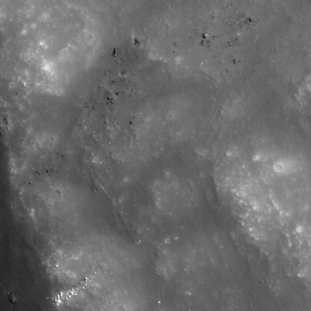
Hansteen α (LROC NAC)
Close up on the heights (-923.8 elev.) of Hansteen α (AKA, "Mons Hansteen" and "the Arrowhead"), a triangular berg, 25 km long on its three margins, composed of intrinsically bright material and rising here 1030 meters above its neighborhood in south Oceanus Procellarum.  LROC Narrow Angle Camera (NAC) periapsis observation M166175569LR, spacecraft orbit 9623, July 24, 2011; 61.74° incidence, slew 16.45° west, resolution 0.5 meters from 41.05 km (Enlarged image HERE.) [NASA/GSFC/Arizona State University].
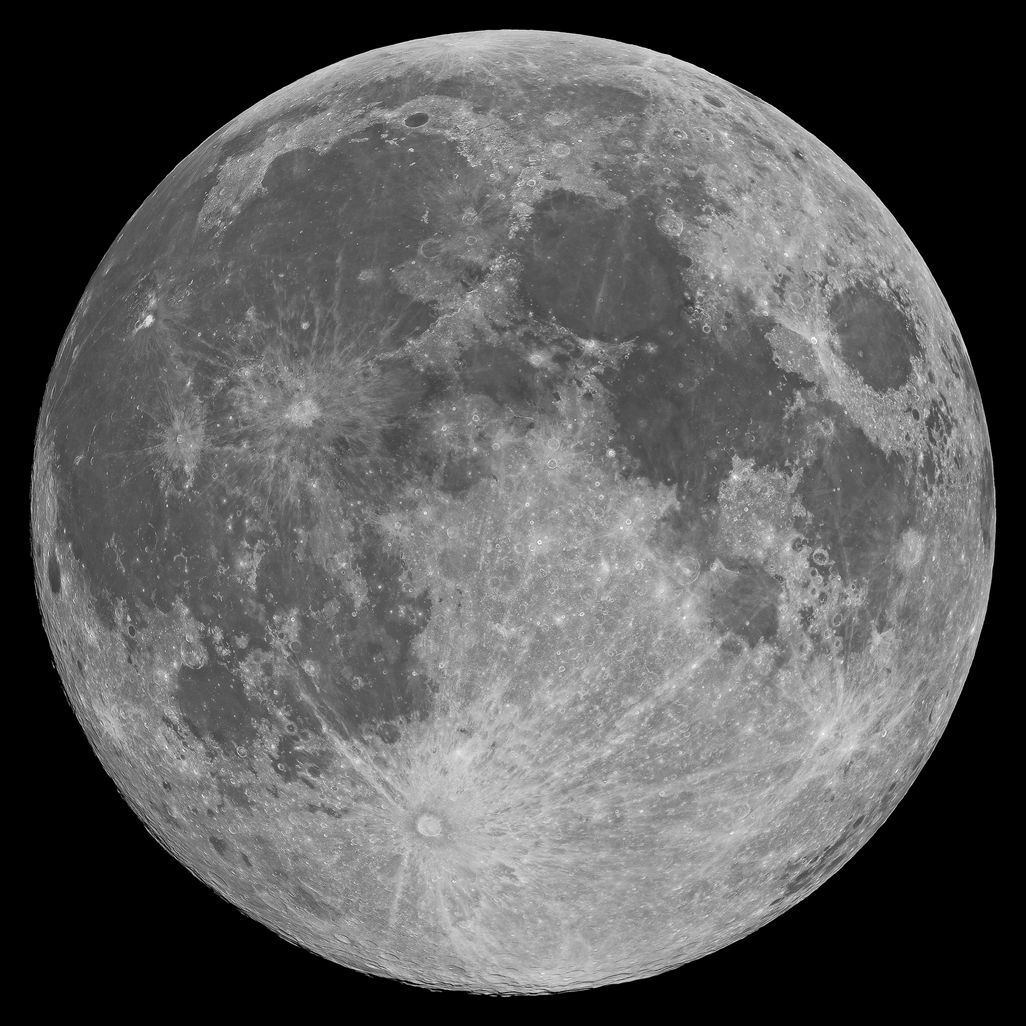
Mons Hansteen (12.2°S, 50.21°W) is a familiar nearside landmark, when viewing a Moon that's almost Full through a modest telescope. As the reader can see in the picture of the Full Moon at the end of this post, it stands out from its surroundings in the far south Oceanus Procellarum.

It's nicknamed "the arrowhead" because it looks like one, like, long-ago, it was knapped to a point by the patient hand of a hunter and now rests half buried in the darker mud of a trail, perhaps uncovered by a recent downpour.

Close investigations of the Moon over the past half century reveal what investigators call "Hansteen Alpha," or Hansteen α, stands out geologically and in other ways. The small mountain is made of different stuff than most of what is found on the lunar surface and the volcanism that flooded and re-flooded the Moon's basins. It's optical brightness is complimented by differences at other wavelengths as well, presenting a spectral profile found in only a few other locations on the Moon. 

Hansteen α is one of the Moon's red spots, bright with an albedo similar to the lunar highlands but spectrally red, brighter in shorter wavelengths and characterized by absorption in the ultra-violet (UV). 

Moreover, it must be a younger feature than it might seem on first glance, younger than certain of the larger craters nearby and other features in its neighborhood that were clearly overrun repeatedly by the darker basaltic lavas that periodically flooded and re-flooded the lower elevations over a period nearly three billion years long.
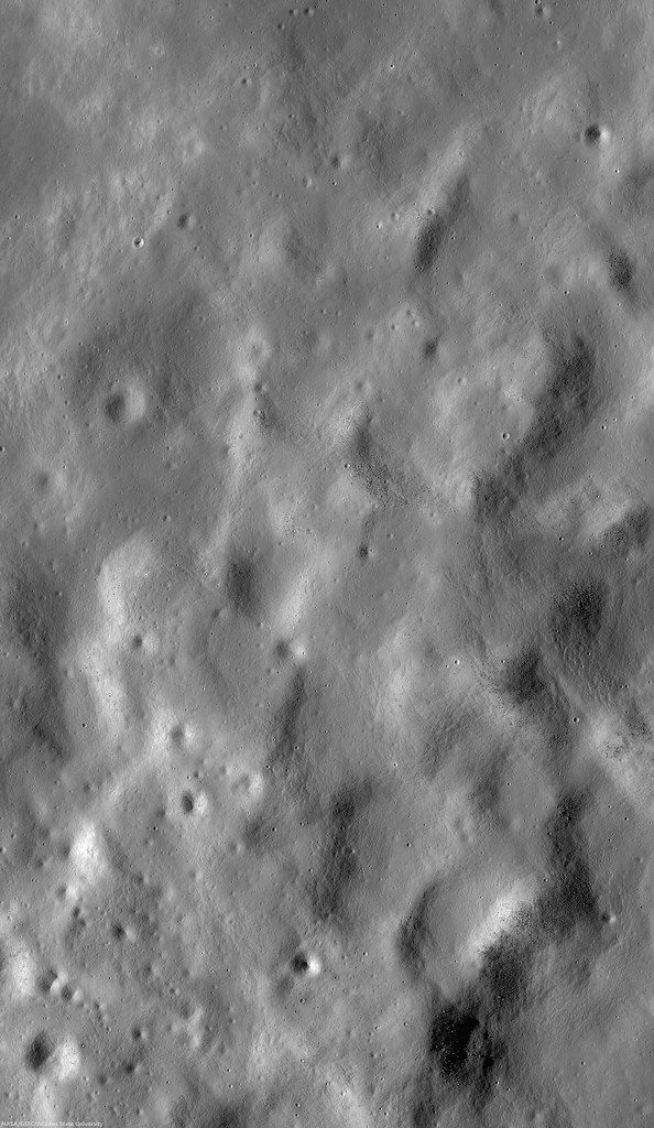
Hansteen α (LROC NAC)
The heights in the first image are at lower right in this 3.94 km-wide field of view, the full width of the area captured from LRO in LROC NAC M166175569LR, and showing a cross-section of Hansteen α from that central area north to more lower elevations, nearer the mountain's northwestern margin. (View larger sizes HERE.) [NASA/GSFC/Arizona State University].
Hansteen a (LROC WAC 250m)
Hansteen α is younger than craters Billy (45.57 km across and 3.88 billion years old, to the south) and Hansteen (45 km across and 3.87 billion years old, to the west), because both are less than one and a half times their respective diameters in distance, and the impacts that excavated these features should have at least partially covered the bright mountain. Instead, no evidence of such a direct effect has been found, only peppering of more recent impacts. LROC Quickmap at 250 meters resolution [NASA/GSFC/Arizona State University].
Hansteen α resembles the Moon's highlands but, beginning early in the post-Apollo era, investigators noted differences in texture, color and measured albedo. In the close-ups at the beginning of this post, showing some of the highest elevations of Hansteen α, depressions can be seen clustered on terraces. These seem to have once been volcanic vents.  Volcanic vents are not particularly rare on the Moon, but the kind of material that emerged from these is clearly not the same stuff that flooded its surroundings.
LROCQM064-H-a-580x746
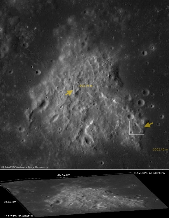
A closer look at Hansteen α elevations, with locations marked of areas shown in LROC NAC observations posted here, the highest elevations and, further along along, some solidified flows on the steep southeastern margin, included below. LROC Quickmap at 64 meters resolution, together with the LROC WAC-derived digital terrain model [NASA/GSFC/Arizona State University].
Using an experimental 3D visualization tool, accessed through the LROC Quickmap. a 152 square km area, centered on Hansteen α, animated between 0 and 10 X vertical exaggeration, further illustrating highest elevations, southwest of the formation's center; something more difficult to measure using 2D overhead photography [NASA/GSFC/Arizona State University].
The margins of Hansteen α seem abrupt, with steeper slopes than is found around the edges of the more common basaltic domes. This might be in keeping with suggestions that the kind of lava emerging into and out of this feature was thicker, related to its composition and the heat necessary for melting and transport. It also provides geologists with clues about its age relative to the volcanism that flooded Procellarum in this region.  

The Hansteen α might have formed from a "secondary," and "more evolved" volcanism, something certainly less common than the basaltic lavas that flowed out into the Moon's broad basins, not once but repeatedly, over a 2.7 billion year period, from the Nectarian age, when the Moon and Earth were only 600 million years old, until just prior to the Copernican period 1.2 billion years ago.

These more recent high-resolution images from LRO show groupings of blocky boulders, mostly related to mass wasting along slopes though some of these clusters are found on level areas and don't appear to be the result of impacts.
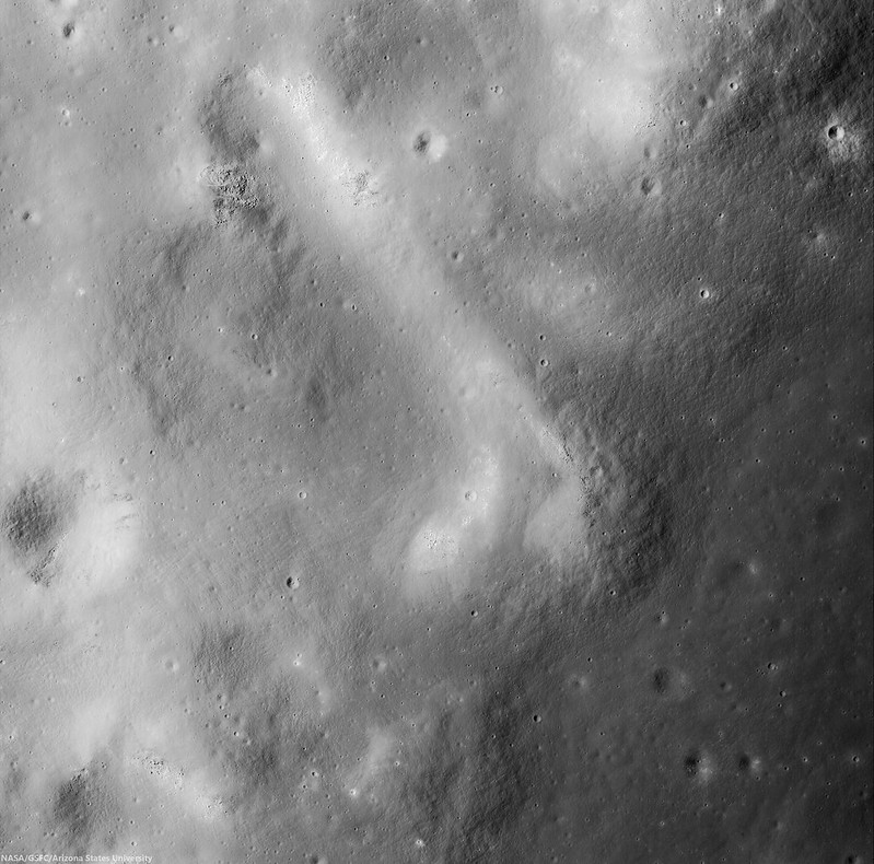
Intrusive volcanism Hansteen Alpha
An intrusive flow, clearly visible on the abrupt southeastern margin of Hansteen alpha,  right where it solidified, This is a 3.93 km square field of view from LROC NAC observation M1129816872R, orbit 18636, July 30, 2013; 42.35° incidence, 80 cm per pixel resolution from 80.7 km over 12.2°S, 310.14°E  [NASA/GSFC/Arizona State University].
Intrusive volcanism Hansteen Alpha
Contextual view of the full 7.8 km-wide field of view swept up in the same LROC NAC  observation, showing a wider view of southeast margin of Hansteen α. Such close-ups reveal that the margin here is more abrupt than it seems at a distance. (Enlarged views and various other sizes available HERE.) [NASA/GSFC/Arizona State University].
So, just what is Hansteen alpha? In two papers presented in 2011 and 2012 to the Lunar and Planetary Science Conference, Hawke, et.al., representing some of the more noted investigators working with data returned from LRO (the more recent of these being  "The Geology and Composition of Hansteen Alpha," 43rd Lunar and Planetary Science Conference (2012), #1754), wrote, "Non-mare volcanism is the only viable process for the formation of Hansteen α."

That paper, along with others those investigators cite, along with still others cited as references below, present truly fascinating discussion of how instruments on-board Clementine (1994), Lunar Prospector (1998-99) and both the LROC cameras and the Diviner instrument, flying on LRO since 2009, are actively being used to weed out the history of this unique feature and how it relates to the complicated volcanic stratigraphy of the Procellarum basin.
Finding Hansteen alpha (Mons Hansteen)
Finding Hansteen α through a modest telescope is relatively easy, from about four days after First Quarter through three days after Last Quarter, on the south edge of Oceanus Procellarum, as shown in this well-crafted mosaic by Stephan Lammel. Look for it left of center in the inset and in the Full Moon, above.
References:

Related ASU LROC Posts:
The Fourth Marian Dome (April 17, 2013)
Aristarchus Spectacular! (December 26, 2011)
Silicic volcanism on the Moon (February 14, 2011)

Tuesday, July 16, 2013

Amazing peaks and valleys in new Orientale NAC oblique

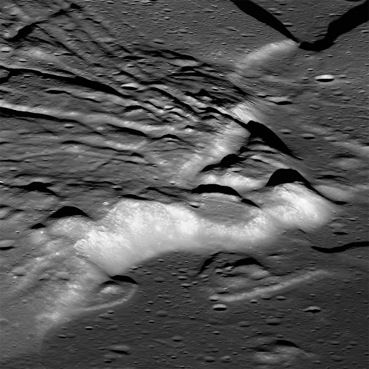
Spectacular oblique view of the interior of the Orientale basin. LROC Narrow Angle Camera (NAC) mosaic M1124173129LR, LRO orbit 17842, May 26, 2013, centered at 24.23°S, 264.30°E. The scene cropped above shows a field of view approximately 16 km across, and the cliffs at center rise almost 2 km over the southwestern interior edge of the basin floor. Native resolution 2.59 meters per pixel [NASA/GSFC/Arizona State University].
Brett Denevi
LROC News System

With an estimated age of around 3.8 billion years, and a diameter of over 900 km, the Orientale basin is the youngest of the large lunar impact basins.

Its interior is relatively well preserved and its floor has not been completely buried under mare basalts, making it one of the most studied basins on the lunar surface in the hopes of unraveling the mechanics of multi-ring basin formation and the relationships of volcanic infilling to large basins.

Today's featured image highlights some of the more bizarre and complex features inside the southwestern portion of the basin, where primary features related to the basin itself meet the later-forming mare basalts in the basin floor.

Miniature (view the 1280x720 animation HERE) composition of five frames of HDTV captured by Japan's lunar orbiter Kaguya (SELENE-1) in November 2007.  In polar orbit more than 100 km over Mare Orientale Kaguya moves north. Beginning far to the south the slideshow begins with the inner mountain ring like a wide plateau looming on the horizon and minutes later the inner basin and lava-flooded basin floor comes prominently into view, including the area shown at high resolution in the LROC NAC oblique mosaic. Afterward, the final frames linger a moment over prominent Maunder crater and the high mountainous rings and valleys of north Orientale. Widespread terrain disruption by the basin-forming impact is uninterrupted throughout the entire sequence [JAXA/NHK/SELENE].
View the Kaguya Image Gallery HERE

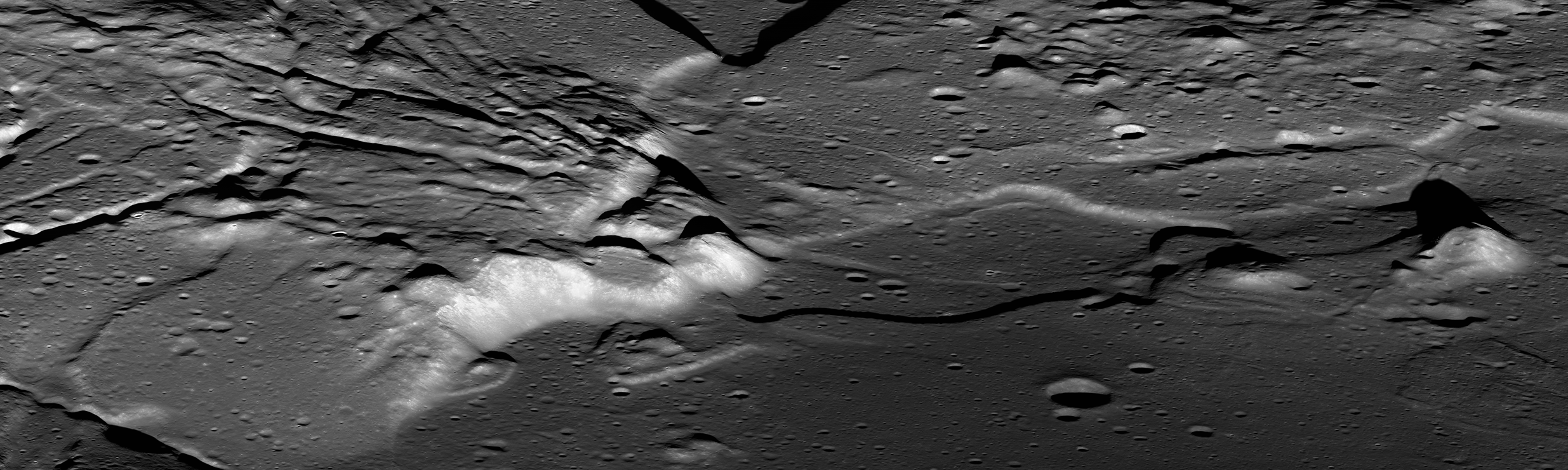
A reduced-resolution version of the oblique NAC mosaic of the Orientale interior. The thumbnail above links to a 2470 by 740 reproduction HERE, while the zoomable, full-resolution view is viewable HERE [NASA/GSFC/Arizona State University].
The striking linear features seen in the top image are portions of a series of cracks that are near-radial to the basin and are unlike typical lunar graben. This portion of the interior is thought to have a high proportion of material that was melted by the extreme shock pressures of the impact event that crated the Orientale basin, and the cracks may have formed as the hot material, draped over underlying topography, cooled and shrank. It is hard to picture the effects of an impact so large it would have obliterated the state of Texas, but here you can almost see the molten and shifting terrain settling and cracking.

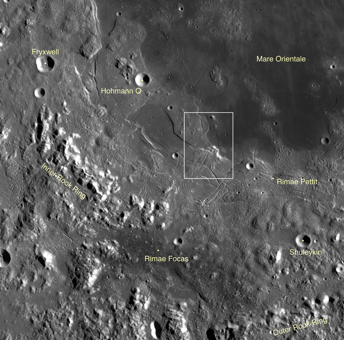
LROC Wide Angle Camera (WAC) context view of a portion of southwestern Orientale basin featuring the approximate area shown in NAC mosaic (white box) M1124173129LR [NASA/GSFC/Arizona State University].
You can also get a sense of how basaltic lavas, the lower-reflectance deposits seen at bottom right, poured in later, flooding low areas, lapping up against the higher-standing terrain, and leaving kipukas of original basin material exposed in some spots. These lavas are estimated to have erupted on the order of 100 million years after the formation of the Orientale basin, but were not as voluminous as the basalts that bury all but the rims of other lunar multi-ring basins, such as Serenitatis and Imbrium. The WAC image mosaic of the region, seen below, helps put these features into context. Here you can see the Orientale mare deposits lie largely within the innermost ring of the basin, the Inner Rook mountains. (The other rings are named the Outer Rook mountains, also seen below, and the Cordillera mountains, which lie outside of the context image.)

Why did these basalts fill regions largely contained within only the innermost ring of Orientale, whereas other basins were totally flooded? Orientale may have formed in a region of thicker crust, making it harder for basalts to erupt from the mantle to the surface anywhere but the center of the basin, where the crust was thinned the most. The composition of Orientale's basalts is also known to be different from the major nearside maria, with a lower concentration of radioactive heat-producing elements (known as KREEP), so there may have been less heat available to melt the mantle to produce basalts.


GRAIL MoonKAM video stills sequenced into nadir and off-nadir low-orbit HD views of Mare Orientale (2:00). The area of interest is visible between 1:05 and 1:15 [NASA/JPL-Caltech/Sally Ride Science].

This interplay of spectacular, complex features related to basin formation and later volcanic eruptions means Orientale is a high-priority target for exploration. Samples would pin down the exact age of the basin, important for answering questions about chronology across the Solar System, as well as answer a host of other questions about basin formation and evolution. And what a beautiful view you'd have, standing at the base of Orientale's cliffs!

View the full-resolution NAC mosaic of beautiful Orientale HERE.

Related LROC Featured Images:
Sinuous Cracks
Geologically recent debris flow at Couder
Orientale Basin
A digital terrain model of the Orientale Basin
Chain of secondary craters in Mare Orientale
Dark halo crater in Orientale!

Saturday, November 3, 2012

Ocean of Storms, Oceans of Argument

Oceanus Procellarum, the "Ocean of Storms," is easily the largest feature of the Moon's complex topography visible, even to the naked eye, from Earth. But is it a true remnant of a basin-forming impact, merely a low remnant of early lunar morphology or perhaps the largest remnant of a hemisphere-sized impact some have labeled "Gargantua? Thumbnail of a 48-image mosaic captured by Yuri Goryachko, Mikhail Abgarian and Konstantin Morozov (ASTRONOMINSK) of Belarus, August 3, 2010.
Paul D. Spudis
The Once & Future Moon
Smithsonian Air & Space

Once upon a time, back in the Dark ages when I was a young student of lunar science, an idea was advanced that Oceanus Procellarum (the largest dark maria on the near side of the Moon) was the site of an ancient, almost obliterated impact basin.  This “Procellarum basin” (then called the “Gargantuan” basin – superlatives fail us sometimes) has been invoked to explain any and every observed aspect of lunar geology, from the distribution of the dark mare lavas, the near/far side dichotomy, the thickness of the crust, the composition of highland rocks, and the relative amounts of radioactively generated heat flow in the Moon.  Such a useful concept to explain so much!

The acceptance by lunar scientists of a Procellarum basin has waxed and waned over the years.  Originally proposed by Peter Cadogan in 1974, the presence of a large, ancient impact basin covering most of the western near side of this part of the Moon, was advanced to explain the unusually high concentration of the chemical component called KREEP – (K) potassium, (REE) rare earth elements, and (P) phosphorus.  Subsequently, Ewen Whitaker (noted cartographer of the Moon) carefully mapped landforms, such as ridges and massifs (mountains) over this area, which purportedly showed that the patterns were best explained by a three-ring basin – 3200 km across, centered on the western near side.  Whitaker named this feature the “Procellarum basin” after the largest mare region that filled it.  Lunar geologist Don Wilhelms fully embraced this interpretation in his classic book The Geologic History of the Moon, making the Procellarum basin the prime cause for the distribution of geologic units on the Moon.

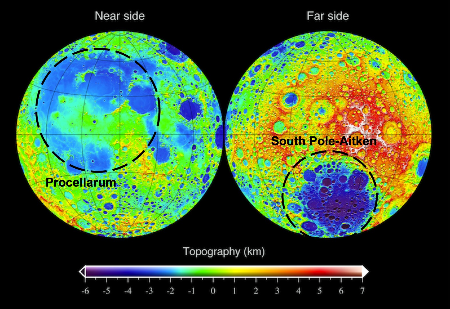
LRO topographic map of the Moon, showing the approximate outline of the "Procellarum" basin on the near side (left) and the South Pole-Aitken basin on the far side (right). One's real, the other isn't.
Yet doubts persisted.  In 1985, Peter Schultz and I suggested that the quasi-concentric arrangements mapped by Whitaker, were related to the Imbrium basin (not to an earlier, underlying mega-basin) on the basis of the ring pattern of this putative feature.  We also pointed out that the patterns of rock compositions supposedly explained by a Procellarum basin were not consistent everywhere, at least casting doubt on the predictive power of the basin’s presence.  The 1994 Clementine mission gave us our first global topographic map of the Moon.  Interestingly, that map dramatically revealed the presence of a circular mega-basin on the far side of the Moon – the enormous 2600 km-diameter South Pole-Aitken basin.  The Procellarum region was also shown to be a low region, but it is not circular (more horseshoe-shaped) and is not as clearly defined as Whitaker’s ring structure suggested.  The stock in the existence of Procellarum basin declined.

But some ideas in lunar science never really go away.  Since that time, several attempts have been made to resurrect the basin.  The latest effort, just published in Nature Geoscience, comes from mineralogical mapping data obtained from the Japanese Kaguya (SELENE) mission.  The authors of this study claim that orthopyroxene (a magnesium-silicate mineral) is distributed on the Moon in association with its largest basins – South Pole-Aitken and Imbrium.  However, in addition to those occurrences, additional outcrops occur in the highlands adjacent to Oceanus Procellarum.  Therefore, these rocks were made during the slow cooling of an enormous impact melt sheet created by the impact which formed the Procellarum basin.

The logic here seems weak.  It has not been established that orthopyroxene only forms from the slow cooling of an impact melt sheet.  When this mineral occurs with the most abundant mineral of the lunar highlands (plagioclase), it makes up a rock type called norite.  Norite is very abundant on the Moon.  It is the dominant rock type at the Apollo 14, 15 and 17 landing sites and occurs elsewhere on the Moon in quantity.  It is particularly prevalent around the edges of the Imbrium basin and one could argue that norite is a characteristic of that basin and the presence of Procellarum basin to explain its occurrence is unnecessary.  Likewise, the existence here of a large differentiated impact melt sheet is inferred from analogy to a terrestrial example, the Sudbury igneous complex, but even in this case, the impact origin of the terrestrial igneous body is not universally accepted.

Evidence for the existence of Procellarum basin must be sought in its topography.  The clarity and preservation of the far side’s South Pole-Aitken basin in the topographic data is surprising.  This feature is one of the oldest on the Moon, yet it preserves relief of over 12 km (the depth one would expect of a fresh feature).  One might expect such an old feature to be indistinct at best, making the discovery of its large relief one of the surprises of the Clementine mission.  At the same time, Procellarum is a vast irregular depression averaging less than 3-4 km deep; its lack of topographic expression is more in line with what one might expect for the oldest basin on the Moon.  However, unlike all other lunar basins, a topographic bulge 2-3 km high occurs near the center of this feature (near the crater Copernicus).  No other basin on the Moon (or on any other planet) contains interior topography higher than the elevation of its topographic rim; at SPA, all of the terrain within the 2600 km diameter rim crest is lower than its rim.  The unusual relation of a bulge within Procellarum does not support the concept that it is an impact basin.  It seems more likely that it is either a feature of internal origin (possibly related to early melting episodes) or a coalescence of several overlapping impact craters and basins.

The elliptical South Pole-Aitken (SPA) basin, mostly on the Moon's farside though it's mountainous outer ring encompasses the the nearside's polar south and the Moon's lowest elevations. The oldest and largest of the Moon's definitively identified impact basins, recent studies appear to have pushed it's formation back beyond 4.1 billion years ago, within less than 500 million years after the formation of Earth and Moon [NASA/GSFC/LOLA].
As we search for the truth, Procellarum basin may well crop up again.  But for today and contrary to the current space press, the new results do not uniquely point to the existence of a large basin here.  In fact, the observations tend to support previous ideas that it is the smaller, overlying Imbrium basin that is associated with a large regional ejecta blanket of roughly noritic composition.

Originally published at his Smithsonian Air & Space blog The Once and Future Moon, Dr. Spudis is a senior staff scientist at the Lunar and Planetary Institute. The opinions expressed are those of the author and are better informed than average.

Friday, February 12, 2010

LROC: Constellation Region of Interest - Crater wall in Van de Graaff


Wall of crater Van de Graaff C
, where brighter material is exposed by more active processes associated with steeper slopes, recent small craters, and even individual rolling boulders. LRO Narrow-Angle Camera image M112822306L, image width 0.68 km [NASA/GSFC/Arizona State University].


Peter Thomas
LROC News System

Wall and rim of a ~20 km diameter crater within the ~240 km diameter Van de Graaff crater, which is one of the Constellation regions of interest. Located on the lunar far side, Van de Graaff crater is south of Aitken crater on the outer edge of the South-Pole Aitken basin. Van de Graaff exhibits an unusual figure-eight shape, ~240 x 140 km, in a region with "swirls", magnetic anomalies, and geochemical anomalies. Swirls on the Moon are high-reflectance, irregularly-shaped markings with gradational boundaries, and they are associated with poorly understood magnetic anomalies (weak by terrestrial magnetism standards).

Magnetic fields like the one near Van de Graaff are relatively unusual for the Moon, because the Moon does not currently have a global magnetic field like the Earth does. Orbital geochemistry measurements show that Van de Graaff and the surrounding terrain have slightly higher concentrations of thorium, which suggests the presence of a geochemically important thorium-rich lunar material called KREEP. Van de Graaff is on the opposite side of the Moon from the massive Imbrium basin, suggesting that perhaps the magnetic and geochemical anomalies are related to the gigantic Imbrium impact event. Or, on the other hand, the anomalies could represent the products of local geologic events. Lunar scientists won't know for sure until we can send human explorers to investigate the region.

Also of particular note in the steep crater walls are higher-reflectance areas. The elevated reflectance is the result of disturbing the regolith (soil) through geologic mechanisms including recent impacts, mass wasting, and by rolling boulders that leave trails. During these events, material from rocks from beneath the surface are exposed. The lunar regolith is typically very fine-grained and is profoundly affected by exposure to the vacuum of space. Over time, radiation and micrometeorite bombardment lower the reflectivity and alter the chemistry of the surface. The high-reflectance, unaltered material exposed at the surface stands out in contrast to the lower-reflectance, older, altered surface.

Explore this fascinating Constellation region of interest for yourself, and check out an Apollo metric orbital photograph of the region!


Apollo 15 Science Mapping camera image 0075 (1971) unveils the north (right) wall of Van De Graaff at sunset, the beginning of the first orbital opportunity. The wispy, relatively bright material on the darkened, optically mature crater floor is associated with one of the Moon's crustal magnetic fields. The same dynamic processes that mature and darken the lunar surface over periods as long as 900 million years, gardening the surface and creating submicron-sized dust, also continuously keep newly exposed, low optically mature material at the surface [Apollo 15/LPI].

Friday, January 8, 2010

Mare Moscoviense Constellation Site


A very subtle mare-highlands boundary in Mare Moscoviense on the lunar farside, near the center of the Constellation Program region of interest. The generalized geologic contact between the mare and the highlands has been highlighted (mare to the left, highlands to the right). Astronauts exploring this region could collect key samples from the farside basalts of Mare Moscoviense as well as materials from the surrounding basin massifs. Image width is 600 meters [NASA/GSFC/Arizona State University].


Samuel Lawrence
LROC News System

The primary mission of the Lunar Reconnaissance Orbiter is to collect the data necessary to enable the human exploration and development of the lunar surface. The instrument suite of the spacecraft, including LROC, was specifically designed with this overarching goal in mind.

Today, the LROC Team begins a new series of Featured Images highlighting the regions of interest for future human lunar exploration that we are imaging for NASA's Constellation Program.

There are fifty of these sites, which were selected prior to LRO launch based on expert input from the lunar science community and NASA engineers. For each of these fifty sites, the LROC Team is collecting a comprehensive set of image data, including observations for geometric and photometric stereo and complete nadir coverage (with repeat imaging at varying illumination). These images, and the associated information products derived from them (such as boulder distribution maps, slope maps, and digital terrain models), will be used by engineers and scientists preparing for the next generation of human lunar exploration. For more information on LROC's observation campaign for the Constellation Program regions of interest read this Lunar and Planetary Science Conference abstract, and visit the LRO Science Targeting Meeting website (look for the baseball card summary sheets for each site: part 1, part 2).

Lunar scientists have been studying the vast data return from the Apollo missions for almost forty years. As a result, much is known about the Moon. For example, we know how to leverage lunar resources to enable future human lunar habitation. Even so, there remains much that we do not know about the Moon. Accordingly, each of these fifty sites is associated with either an immensely compelling lunar science question or an Exploration-enabling resource that will be useful to future explorers, or both. However, these fifty sites aren't intended as actual NASA landing sites, but instead are representative locations whose study will provide mission planners and lunar scientists working on future human lunar exploration with lots of data for a comprehensive suite of interesting and relevant terrains all over the lunar surface. Having said that, each of these locations really would make a great place for the seventh (and the eighth, and ninth, and tenth...) human lunar landing and beyond as we prepare for the long-awaited return of astronauts to the lunar surface. We hope you enjoy these guided tours of some of the most fascinating places on the lunar surface - places where humans should be productively exploring, living, and working in the not-too-distant future.

Mare Moscoviense: Window to Farside Volcanism

It's clear from looking at pictures of the Moon that the nearside and the farside are very different from a geologic standpoint. The low reflectance, basaltic mare deposits dominate the nearside, whereas the bright deposits of anorthosite thought to be remnants of the Moon’s original crust dominate the farside. Mare Moscoviense is one of the few (and also the largest) deposits of mare basalts on the lunar farside.


Figure 1. Clementine 750 nm mosaics showing the lunar nearside and lunar farside, with the location of Mare Moscoviense highlighted [USGS/Arizona State University].


Why are there so many mare basalts on the nearside, but so few on the farside? Lunar scientists simply don't know the answer to that question, although we have some ideas. One idea is that the farside crust is simply thicker than the nearside crust, and the rising bodies of basaltic magma simply solidified before they were able to push through the thicker farside crust. However, we won't know for sure until we can get human explorers to the farside to collect samples, and that's where Moscoviense comes in. We know enough about the Moscoviense region from previous missions that we have a well-defined set of questions we can answer by sending human explorers. For example, the Lunar Prospector mission showed that there are relatively high concentrations of thorium in the Moscoviense basin. Thorium acts as a tracer for the lunar KREEP geochemical component found in abundance on the nearside but not on the farside. Understanding the extent and distribution of thorium in the basin may tell us about the global distribution of the lunar KREEP component and thus the evolution of the lunar mantle. We also know from the Clementine mission that the Moscoviense basalts are both iron and titanium-rich. Since basalts form by partial melting of the lunar mantle, sampling Moscoviense basalts provides lunar scientists with vital insights into how the lunar mantle on the farside differs from the nearside mantle, which in turn would help us to learn why mare basalts are so much rarer on the farside and provide key insights about the formation of all of the terrestrial planets, including Mars and Earth.

For these reasons, a Constellation region of interest is located within Mare Moscoviense. As you can see in Figures 2 and 3, the landing site is at the edge of Moscoviense, allowing would-be explorers to collect samples from both the mare basalts and the surrounding highlands terrain during their traverses. A previous LROC Featured Image also shows the Moscoviense-highlands boundary just a few kilometers south of today's image. The materials at the edge of the basin provide important insights into the formation of the Moscoviense basin itself. By exploring and sampling the Moscoviense region, we would date the basalt flows and definitively determine their composition. This sampling would allow us to determine how Moscoviense basalts differ from the nearside basalts sampled during Apollo. Directly determining the age of Moscoviense basalts with laboratory analysis provides important insights into the history of lunar volcanism by determining where the Moscoviense basalts fit in the Moon's volcanic history.


Figure 2. LROC WAC (Red=689, Green=566, Blue=415 nm) mosaic with the location of the proposed Constellation region of interest indicated with arrow [Arizona State University].


While the scientific goals of exploring the Moscoviense region are certainly important, no less important is access to key lunar resources. The lunar regolith (the broken-up rocks and impact products that make up the first 10 meters or so of the lunar surface) in this region is derived in part from the local titanium-rich Moscoviense basalts. This regolith material could be used for a variety of vital purposes, including the construction of human habitats, radiation shielding, or as feedstock for local resource utilization. Taking a longer view, titanium is an important industrial material on Earth, and it will be very important for indigenous lunar industrial development.


Figure 3: Twenty times downsampled mosaic of LROC NAC images M105887165LE and M105887165RE showing location of the Moscoviense Constellation region of interest; image is 77.6 km tall by 14.5 km wide [Arizona State University].


Explore the Mare Moscoviense Constellation region of interest for yourself, and imagine what it would be like to plant your own boots in the lunar surface!

Explore a previously released NAC image showing another portion of the Moscoviense basin.