Showing posts with label USGS. Show all posts

Tuesday, March 18, 2014

681 Gigapixel LROC mosaic

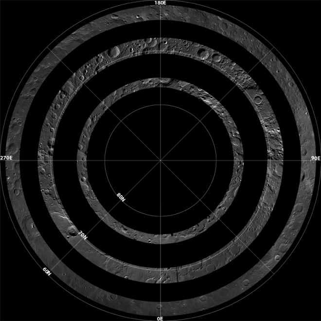
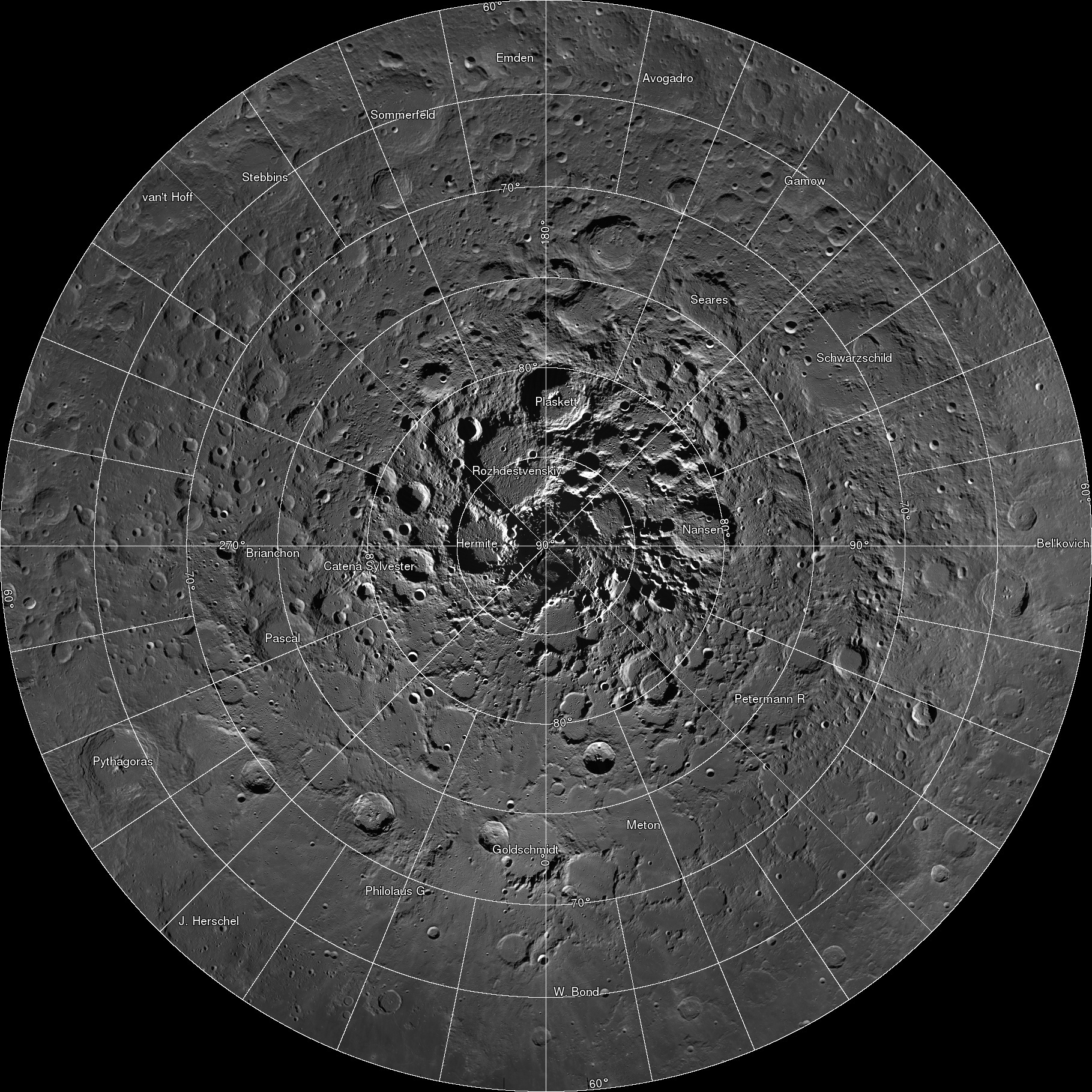
Spectacular LROC Northern Polar Mosaic (LNPM) allows exploration from 60°N up to the pole at the astounding pixel scale of 2 meters [NASA/GSFC/Arizona State University].
Mark Robinson
Principal Investigator
Lunar Reconnaissance Orbiter Camera
Arizona State University

The LROC team assembled 10,581 NAC images, collected over 4 years, into a spectacular northern polar mosaic. The LROC Northern Polar Mosaic (LNPM) is likely one of the world’s largest image mosaics in existence, or at least publicly available on the web, with over 680 gigapixels of valid image data covering a region (2.54 million km2, 0.98 million miles2) slightly larger than the combined area of Alaska (1.72 million km2) and Texas (0.70 million km2) -- at a resolution of 2 meters per pixel! To create the mosaic, each LROC NAC image was map projected on a 30 m/pixel Lunar Orbiter Laser Altimeter (LOLA) derived Digital Terrain Model (DTM) using a software package called the Integrated Software for Imagers and Spectrometers (ISIS).
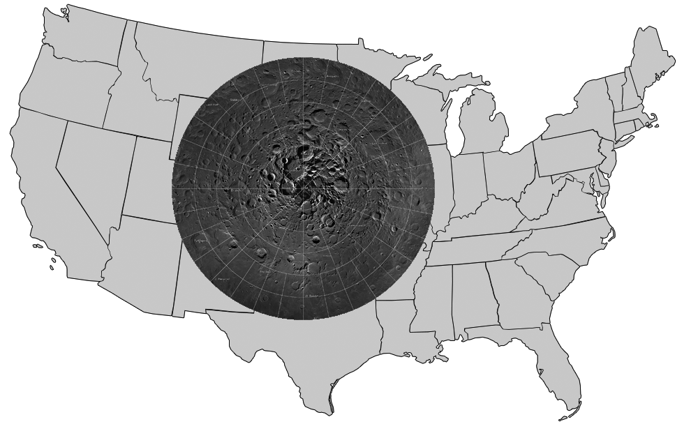
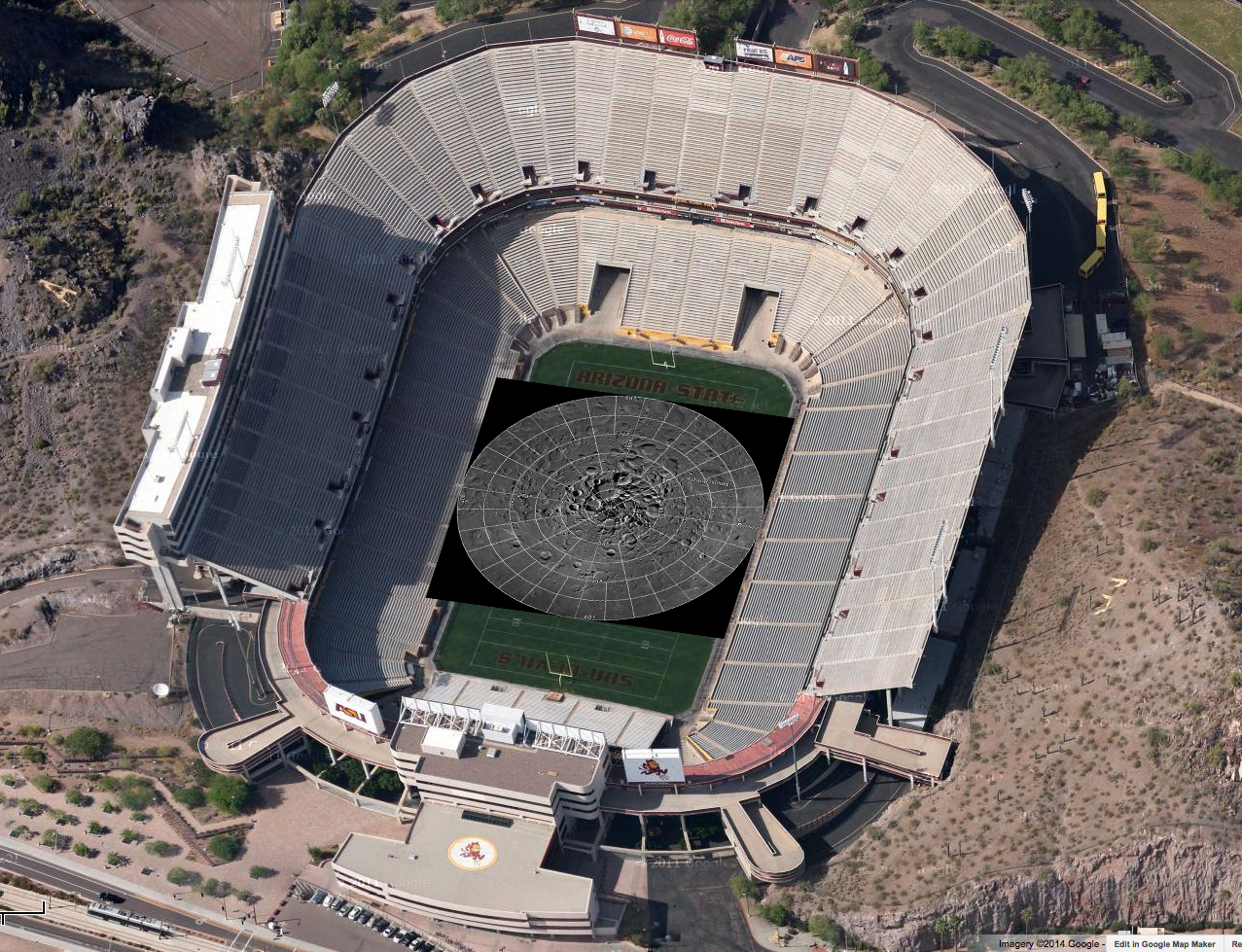
Figure 1. LNPM superposed on map of the United States.
A polar stereographic projection was used in order to limit mapping distortions when creating the 2-D map. In addition, the LROC team used improved ephemeris provide by the LOLA and GRAIL teams and an improved camera pointing model to enable accurate projection of each image in the mosaic to within 20 meters. Almost exactly 3 years ago the LROC team released a Wide Angle Camera (WAC) mosaic of the same north polar region, the pixel scale was 100 meters.

The new NAC mosaic is 50x higher resolution!
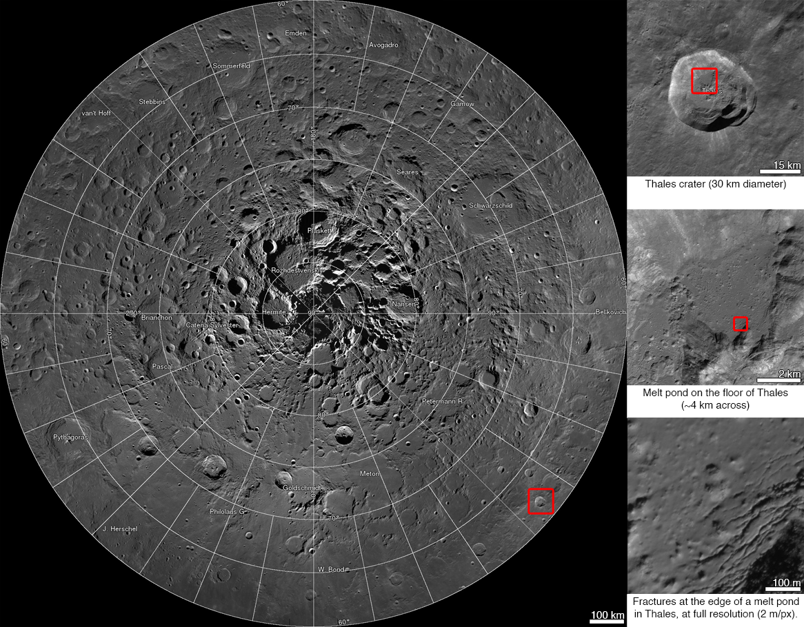
LNPM with three levels of zoom down into Thales crater [NASA/GSFC/Arizona State University].
The LNPM was assembled from individual "collar" mosaics. Each collar mosaic was acquired by imaging the same latitude once every two-hour orbit for a month during which time the rotation of the Moon steadily brought every longitude into view. Each collar mosaic has very similar lighting from start to end and covers 1° to 3° of latitude.

Three collar mosaics illustrating how the images were acquired over time to build the LNPM [NASA/GSFC/Arizona State University].
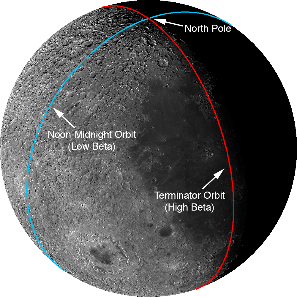
The Moon does have subtle seasons and the LRO orbit cycles between noon-midnight and terminator orbits (measured as the angle between the spacecraft orbit plane and the sub-solar longitude; known as the beta angle). Lighting at the poles is best during northern summer and when the spacecraft is in noon-midnight orbits (low beta). There are a few gaps in the collar sequences due to spacecraft anomalies and special slewed observations that point the cameras off into space. These gaps were filled with images acquired at other times in the mission. These gap-filling images sometimes have the Sun from the opposite direction of the surrounding collar, resulting in noticeable boundaries.

Two types of orbit that LRO experiences through a six-month cycle. Images acquired during terminator orbits have long shadows from the equator to the pole. For noon-midnight orbits the Sun is overhead (no shadows) at the equator and shadows, though still large, are minimized at the poles.
The LNPM was originally assembled as 841 large tiles due to the sheer volume of data: if the mosaic was processed as a single file it would have been approximately 3.3 terabytes in size! Part of the large size is due to the incredible dynamic range of the NACs. The raw images are recorded as 12-bit data (4096 grey levels) then processed to normalized reflectance (a quantitative measure of the percentage of light reflected from each spot on the ground). To preserve the subtle shading gradations of the raw images during processing the NAC images are stored as 32-bit floating-point values (millions of grey levels). The 32-bit values are four times the disk size of the finalized 8-bit (255 grey levels) representation most computers use to display greyscale images. The conversion process from 32-bit to 8-bit pixels results in saturation (group of pixels all with the maximum value of 255) in the brightest areas.

Printed at 300dpi (a high-quality printing resolution that requires you to peer very closely to distinguish pixels), the LNPM would be larger than a football field.
Even with the conversion, the compressed JPEG images that make up the final product take up almost a terabyte of disk space. To create the zooming and panning Gigapan version, multiple versions of each large tile (32,768 pixels square) were made at varying pixel scales. Next, appropriate labels and grid lines were added for each zoom level in hopes of keeping the user oriented – no sense in getting lost on the Moon! Finally these larger tiles were split into 256-pixel square images, allowing a web browser on an average network to keep up with the amazing detail (only a few tens of kilobytes are needed to see any given location at full resolution). In total the LROC NAC northern polar mosaic required 17,641,035 small tiles to produce the final product.

Dive right in HERE, and explore each of the 681 Gigapixels.

LNPM by the numbers:

Square image: 931,070 pixels across and down
Total pixels: 866,891,344,900  (867 billion)
Pixels with image data: 680,808,991,627 (681 billion)
NAC images: 10,581
Image tiles (256x256): 17,641,035 (18 million)
Mass storage of tiles: 950 Gigabytes

Acknowledgments: The LOLA team provided the high resolution topography used to map project the NAC images and improved spacecraft ephemeris that allowed accurate placement of the images on the lunar latitude longitude grid. Gigapan provided mass storage and a web interface. The United States Geological Survey Astrogeology Science Center provided the ISIS image processing software. The NASA LRO project collected the data and funded the processing effort. The LROC imaging suite was developed and built by Malin Space Science Systems (MSSS).

Friday, January 25, 2013

Geological mapping of another world

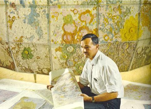
Eugene Shoemaker with some of the first geological maps of the Moon, in Flagstaff, Arizona during the mid-1960's
Paul D. Spudis
The Once & Future Moon
Smithsonian Air & Space

Many people are surprised when they learn that well before the first landing of Apollo in 1969, we already understood the geological history of the Moon.  The idea that such a thing was even possible drew considerable skepticism during early preparations for landing on the Moon.  The principles for the remote mapping of the geology of the Moon came from several closely related but distinct threads.  Eugene M. Shoemaker, a geologist with the U. S. Geological Survey (USGS) who founded the Branch of Astrogeology, laid out the methodology in broad outline from and through the systematic study of lunar surface images in the early 1960s.

One of the basic principles of geology is that younger rocks lie on top of (or intrude into) older rocks.  Interestingly, this relationship can be discerned from a photograph.  In the case of the Moon, images show the dark smooth plains of the maria (lava) and the rough, cratered highlands.  Some craters were found on top of the dark mare plains, while others were filled with mare.  Clearly, the craters on top of the mare formed after those plains existed and were thus younger than the maria.  On the other hand, dark mare that fills a crater must have formed after that crater existed and so in this case, the crater was older.

By following these simple relations over large areas, it is possible to determine the relative ages of mare and craters, both among themselves and to each other.  But such information is trivial unless we can relate these individual ages to some unit or event of regional significance.  In principle, if such a relationship can be defined we can extend relative age assignments over large areas, ultimately on a global basis.

The first effort to map the geology of the Moon was by the USGS, but not by the then-newly created Astrogeology Branch.  Branch of Military Geology scientists Arnold Mason and Robert Hackman produced the “Engineer’s Special Study of the Moon” in 1960.  This special one-off product documented the principal terrain types of the Moon (maria and highlands) and ordered features into three categories of relative age: post-mare craters (youngest), maria, and highlands (oldest).  Additionally, the map showed the distribution of linear features, presumed to be faults (fractures along which movement has occurred), and mare ridges (presumed to be folds) over the near side.  In this sense, the Engineer Special Study was a geological map because it showed the spatial distribution of rock types, their relative ages, and the inferred structure of the lunar surface.  This map was accompanied by a detailed text chart, which showed a region-by-region evaluation of the terrain and construction challenges for each area.  But a critical element was still missing.

On Earth, the geologist recognizes the rocks in the field, maps their locations and orientation, and documents the structure of the area under study.  But a key part of this work is to figure out where a particular area fits in the global column of geologic units.  On Earth, by documenting the slow, gradual nature of geological processes the stratigraphic column was developed slowly over the course of about a hundred years.  The terrestrial stratigraphic column also provided key evidence needed to show the gradual transition of life forms from simple invertebrate organisms in the earliest rocks, to the complex and varied life forms in succeeding strata.  With the development of a global stratigraphic system and accompanying geologic time scale for the Earth, a framework for understanding the history and processes of the Earth was created.

Gene Shoemaker recognized the need for an organized stratigraphy to aid in our understanding of the Moon.  He wanted to understand the Moon’s evolution and age, but also to correlate events on the Moon with events in Earth history.  He recognized that a major step forward to such an end was to define a formal stratigraphic system for the Moon – a clear succession of rock types with key regional units defining the system boundaries.  He began mapping the area around the crater Copernicus, which lies on the central near side of the Moon, recognizing that the rocks exposed there (from what had been discerned from images) represented all the distinct phases of lunar history.

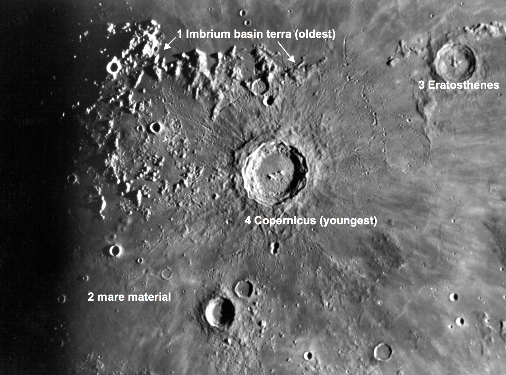
From Earth, a telescopic image of Copernicus and vicinity, showing how the relative ages of geological features are determined using the principle of superposition.
The basic sequence is easy to follow.  The oldest rocks (1) are those that form the highland units of the large, circular Imbrium impact basin.  These units are the mountains that make up the rim of the basin as well as the regional highlands around Copernicus, which are ejecta from the basin forming event.  Partial flooding by the dark, smooth maria followed (2), including both dark, ash-like materials and smooth flood-like plains (interpreted even then as flows of basalt, the most common volcanic rock type on Earth).  These eruptions were followed by the formation of impact craters, of which two kinds could be recognized:  an older group (3) that had slightly eroded and lost their bright rays (such as Eratosthenes) and a younger group (4) that preserved the bright rays and showed a fresh, unmodified form (such as Copernicus.)

Shoemaker used these rock units to define the lunar time-stratigraphic systems:  the Imbrian, Procellarian, Eratosthenian and Copernican Systems were each assigned to represent an archetypical deposition event.  Rocks that existed before the formation of the Imbrium basin were assigned to an informal category, the pre-Imbrian.  Thus, Shoemaker created a geologic map that not only showed the distribution of rock units and the structure of a given area, but also classified these rock types into a stratigraphic column for the Moon, one that (because of the enormous extent of the Imbrium basin) could be applied to areas across the lunar near side.  With slight modification (the “Procellarian” System is no longer used and the pre-Imbrian has been subdivided into the Nectarian System and pre-Nectarian), this classification scheme subsequently has been applied to the entire Moon.

Shoemaker’s work on geologic mapping of the Moon gave us the ability to immediately put the lunar samples returned by Apollo into a regional and global context.  We found that most lunar events occurred very early in its history, with intense geological activity in the first 1-2 billion years and little activity since.  Thus, the Moon’s geological record perfectly complemented that of the Earth, whose traces of earliest activity have been erased over time by the active processes of erosion and plate tectonics.

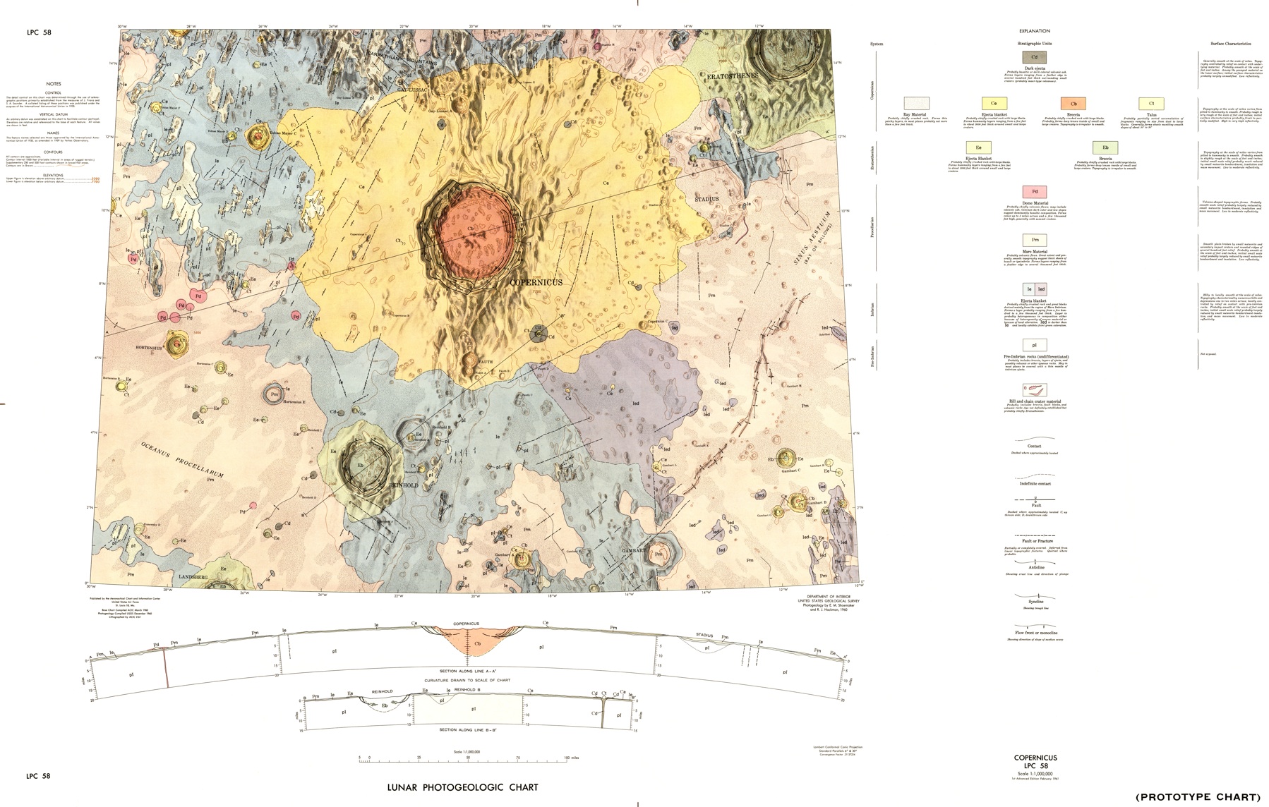
The first geologic quadrangle map of the Moon, showing rock units (basin, crater and mare materials), structures and their stratigraphic arrangement.
The 1960 Copernicus Prototype Chart LPC-58, the first true geological map of the Moon, was not formally published by the USGS, though a modified and updated version was published later in that decade.  By then, Gene had picked up a couple of co-authors for his effort, including one Harrison Hagan Schmitt (a young geologist with the USGS in the early 1960s), who in 1972 ultimately got the chance on the Apollo 17 mission to do what Gene Shoemaker originally got into the space business to do – check the interpretations of the remote lunar geologic mapping by doing field work on the Moon.

Click HERE to view Shoemaker’s LPC-58 geological map at full resolution.

Just publishedThe Clementine Atlas of the Moon, Revised Edition, an updated atlas and reference guide to lunar features, by Ben Bussey and yours truly.

Originally published at his Smithsonian Air & Space Magazine blog "The Once and Future Moon," Dr. Spudis is a senior staff scientist at the Lunar and Planetary Institute. The opinions expressed are those of the author and are better informed than average.

Thursday, January 24, 2013

'When we blew up Arizona to simulate the Moon'

The first round alone required 141.75 kg of dynamite and 6120 kg of fertilizer mixed with fuel oil. Archive photograph [NASA/USGS].
Geoff Manaugh and Nicola Twilley
The Atlantic

In the late 1960s, NASA created an off-world analogue with dynamite and fertilizer bombs outside Flagstaff, Arizona, so that astronauts could train for the Apollo missions.

Thanks to a well-timed tip from landscape blogger Alex Trevi of Pruned, Venue made a detour on our exit out of Flagstaff, Arizona, to visit the old black cinder fields of an extinct volcano--where, incredibly, NASA and its Apollo astronauts once practiced their, at the time, forthcoming landing on the moon.

The straight-forwardly named Cinder Lake, just a short car ride north by northeast from downtown Flagstaff, is what NASA describes as a lunar analogue: a simulated off-world landscape used to test key pieces of gear and equipment, including hand tools, scientific instruments, and wheeled rovers.

Apollo 15 Jim Irwin and Dave Scott of Apollo 15 train in experimental vehicle "Grover" [NASA/USGS].
As Northern Arizona University explains, NASA's Astrogeology Research Program "started in 1963 when USGS and NASA scientists transformed the northern Arizona landscape into a re-creation of the Moon. They blasted hundreds of different-sized craters in the earth to form the Cinder Lake crater field, creating an ideal training ground for astronauts."

Read the full and copiously illustrated article HERE.

Tuesday, January 1, 2013

How are places on the Moon named?

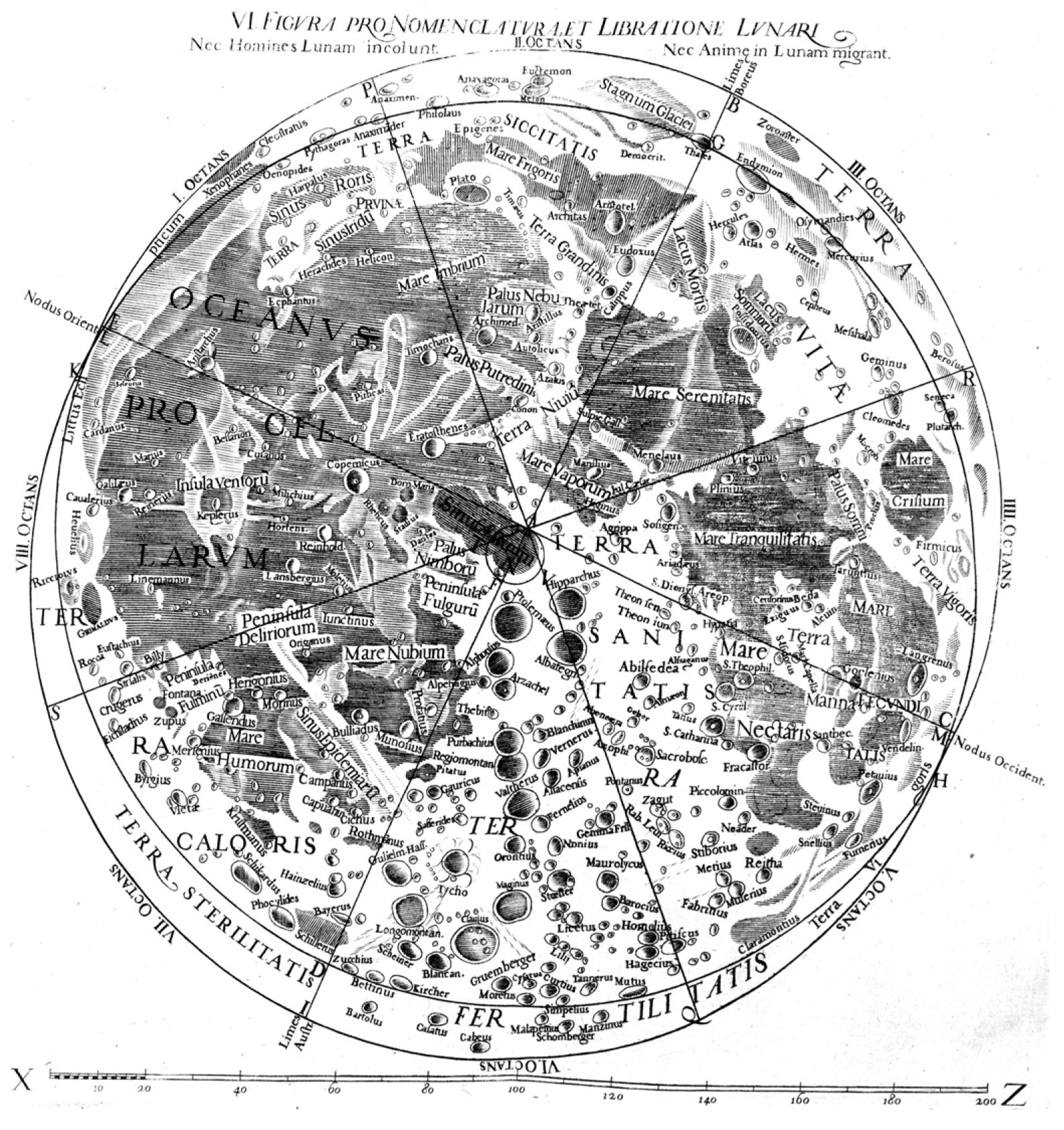
Map of the Moon by Grimaldi and Riccioli, 1651. Most of the names on this map are still in use today.
Paul D. Spudis
The Once & Future Moon
Smithsonian Air & Space

The Moon is remarkable for the variety and unusual nature of the names of its surface features.  The dark, smooth maria are named for weather or states of mind (Sea of Rains, Sea of Tranquility) while many of the abundant craters of the Moon are named for famous scientists, philosophers, mathematicians and explorers.  Before the advent of the space age, only the near side of the Moon was visible from Earth, although most scientists believed that the far side probably looked exactly like the facing one. (How wrong they were!)  Naturally, once we had the ability to see uncharted lunar territory, a new era of name assignment commenced.  But even now, many lunar craters and features await something more than mere coordinates.

The drawings of the Moon in 1610 by Galileo show craters and mountain ranges but he did not assign names to them.  As telescopes improved, revealing finer surface details, several maps appeared with names bestowed by their astronomer authors to flatter patrons or express their nationalism.  Most of those early names have been forgotten to history.  In 1651, an influential map by Jesuit astronomers Grimaldi and Riccioli became the foundation for the official naming reference guide that we use today.

With the flight of the Luna 3 probe in 1959, the Soviet Union was the first nation to image the far side of the Moon.  To the surprise of most, large regions of maria (so prominent on the near side) were mostly missing from the far side.  Although the first images were of very low quality, the Soviets couldn’t resist the urge to name newly discovered features for a variety of Russian heroes and place names, such as Tsiolkovsky and the Sea of Moscow.  Some new “features” were misidentified because of the low resolution – the name “Soviet Mountains” (no longer used) was given to a bright linear streak across the far side globe (a feature that turned out to be a long ray from the fresh crater Giordano Bruno and not a mountain range).

Over subsequent years, as both American and Soviet spacecraft filled in the far side coverage with increasingly higher quality images, most major far side craters received names of various scientists and engineers.   From around the world, a mixed bag of names were submitted to the International Astronomical Union (IAU – the body of scientists who authorize the names of planetary surface features) for consideration and approval.  Although some were historically significant, many were people with whom few were familiar.

Though NASA does not have the authority to assign names to features on the Moon, an informal practice of naming landmarks was common during the Apollo missions.  Names were given to the small craters and mountains near each landing site (e.g., Shorty, St. George, Stone Mountain) but official names were used as well (e.g., Hadley Rille).  NASA adopts informal names for the same reason that names are given to geographical features on Earth – as shorthand to refer to landmarks and other mapped features.  The most recent illustration of this practice occurred on December 17, 2012 when NASA named the location where the deliberately de-orbited GRAIL spacecraft crashed onto the Moon near the crater Goldschmidt (73°N, 4°W) the Sally K. Ride Impact Site.  Sally thus joins other women of science and note who have lunar features named for them – Hypatia, Caroline Herschel and Marie Curie, among others.  Most of the informal names assigned during Apollo were later given “official” status by the IAU.

The Apollo basin (a 540 km diameter crater on the southwestern far side) was named to honor the Apollo missions – the only crater on the Moon so designated.  Within a few years of their missions, smaller craters were named for the living crews of Apollo 8 (Borman, Lovell and Anders) and Apollo 11 (Armstrong, Aldrin and Collins).  Also located around the Apollo basin are craters named for deceased astronauts and NASA employees, including the lost crews of Apollo 1 and the lost crews of the final missions of the Challenger and Columbia Space Shuttles.  It is appropriate that some feature honors humanity’s first efforts to reach the Moon, as well as others who gave their lives pioneering space.  In a similar vein, craters near the poles of the Moon tend to be named for famous polar scientists and explorers, such as Nansen, Shackleton, and Amundsen.

Other than these exceptions, the location of specifically named craters has little rhyme or reason.  Neither scientific prominence nor contribution guarantees any crater-endowed immortality.  Copernicus and Archimedes are rightly honored with spectacular craters named for them.  But Galileo and Newton (titans in the history of science) are fobbed off with insignificant or barely detectable features.  One of the most prominent craters on the Moon is named for the astronomer Tycho Brahe, an eccentric who spent most of his career trying to validate a variant of the Earth-centered, Ptolemaic model of the Solar System (Ptolemy also has a prominent crater in the center of the near side named for him).  It’s not clear why Riccioli assigned the names he did to these craters, though he cannot be blamed for giving Newton short shrift, as the future Sir Isaac was only nine years old when the Grimaldi and Riccioli map was published.

It is possible to both suggest a name and to propose a crater for that name, though the IAU is not obliged to accept either.  Often, a suggested name is approved but assigned to a different crater.  Currently, the guidelines for submission and assignment of new names for lunar craters are: 1) a scientist or explorer who has made some significant contribution, preferably to the study of the Moon and planets; 2) deceased for at least three years before a crater name becomes official; 3) it cannot duplicate any existing lunar name.

In 2005, I proposed the name Ryder (to honor my colleague Graham Ryder, a lunar scientist who passed away in 2002) and suggested a small, bright crater on the far side to carry his name.  Both suggestions were adopted.  We have since found that Ryder crater is actually quite a geologically spectacular feature (Graham would be proud of his namesake).  In a truly singular event, the crater Shoemaker (named in 2000 and located near the south pole of the Moon) actually contains some of Gene Shoemaker’s remains – a small portion of his ashes was carried aboard the Lunar Prospector spacecraft in 1998.  At the conclusion of that mission, the vehicle was crashed into the south polar crater that was subsequently named for him.

We don’t know what the IAU will do concerning the designation of the Sally K. Ride Impact Site but as history suggests, granting of official status is not guaranteed.  No matter – we will continue to assign names to features as needed and the IAU will do what they do.  In the early 1970s, the IAU (by fiat) abolished the famous Mädler nomenclature system (wherein a small, nearby crater is given the name of a large neighbor plus a letter, such as Copernicus H).  Most working lunar scientists stubbornly refused to accept this decision and continued using the old crater names.  After 30 years of bureaucratic intractability, the IAU finally surrendered and formally adopted the Mädler system.

Official or not, with the passage of time, named lunar landmarks will become familiar to those visiting and working on our nearest neighbor.  Perhaps interesting monikers will be attached by those locals, as is done here on Earth when we assign nicknames to places – like the Big Apple, the Windy City, the Big Easy and the City by the Bay.

Just publishedThe Clementine Atlas of the Moon, Revised Edition, an updated atlas and reference guide to lunar features, by Ben Bussey and yours truly.

Originally published at his Smithsonian Air & Space Magazine blog "The Once and Future Moon," Dr. Spudis is a senior staff scientist at the Lunar and Planetary Institute. The opinions expressed are those of the author and are better informed than average.

Thursday, July 12, 2012

The Spirit of the Lunar Orbiters lives in LOIRP

Newly retrieved high-resolution frame (Lunar Orbiter II-13-H2) showing a roughly 4 km-wide area in  south Mare Tranquillitatis, originally photographed, processed and radioed back to Earth by the Lunar Orbiter spacecraft November 18, 1966. It is the center (h2) of three sequential high-res frames captured simultaneous to the imaging of medium resolution Lunar Orbiter observation 2-013. It has been remastered and just released by the remarkable Lunar Orbiter Image Restoration Project (LOIRP) working on the campus of NASA's Ames Research Center in California [Moonviews].
Joel Raupe
Lunar Pioneer

In addition to the five spacecraft the United States presently has in lunar orbit, the legacies left behind by the five Lunar Orbiter spacecraft dispatched in 1966 and 1967, ahead of the manned Apollo landings, collectively amount to a sixth mission, still active and present in more than spirit. Because of the vision and resourcefulness of a special group of engineers and scientists the original tapes containing the raw radio signal returned by the Lunar Orbiters is methodically being processed, essentially for the first time, almost fifty years later. The most recent release of frames originally photographed by Lunar Orbiter II late in 1966 provide us with an easy demonstration of where this growing new library of half-century-old observations fits into our 21st century understanding of the Moon.

Any new craters? On December 21, 2009 the Lunar Reconnaissance Orbiter Camera team swept up much of the territory photographed at high resolution by Lunar Orbiter II in November 1966. The field of view in L2013-H2 is here outlined in yellow. LROC Narrow Angle Camera (NAC) observations M116072806L & R, orbit 2239; angle of incidence 80.6° at 0.96 meters resolution, from 46.3 km [NASA/GSFC/Arizona State University].
Much of the area in the three Lunar Orbiter II high-resolution photographs was surveyed at least once, under a high angle of illumination (80.7°) at slightly better than 1 meter resolution, December 21, 2009. The upper right hand portion of Lunar Orbiter frame 2013 (h2) is also available in the body of Lunar Reconnaissance Orbiter Camera high-resolution Narrow Angle Camera (NAC) observations presently released to the Planetary Data System.
Newly retrieved by the Lunar Orbiter Image Restoration Project (LOIRP), the medium resolution Lunar Orbiter frame 2011 (M) shows a roughly 45 km-wide area in south central Mare Tranquillitatis originally photographed by Lunar Orbiter II, November 18, 1966 (1525 UT). Of the three high-resolution frames of the area, engineered to be captured at the same opportunity, the center frame, h2, is thinly outlined in very pale yellow at the direct center, and is detailed above [Moonviews].
A 3200 square kilometer field of view showing the immediate area of southeast Mare Tranquillitatis visible in a set of two medium and three high-resolution Lunar Orbiter photographs newly retrieved and just released by the Lunar Orbiter Image Restoration Project (LOIRP). The white rectangle outlines cover the area of the lunar surface in two LROC NAC observations overlapping the high-resolution Lunar Orbiter II frames. Fields of view in the Lunar Orbiter high-resolution frames were re-surveyed at high-resolution by the Lunar Reconnaissance Orbiter, 45 years later. LROC QuickMap at 64 meters resolution, LROC WAC Global 100 meter monochrome mosaic [NASA/GSFC/Arizona State University].
LROC QuickMap 4000 meter resolution context view showing the 3200 square km area of the southeast Sea of Tranquility framed in the image immediately above. This part of the Tranquillitatis basin averages out at a bit higher elevation than elsewhere, and is populated by ancient inundated ghost crater rims with the coherent spatter of secondary craters. As our understanding of lunar morphology deepens it has become less clear whether Mare Tranquillitatis constitutes a true basin. Regardless, however, episodic re-floodings by molten material has left behind some of the Moon's deepest mare strata, even if Tranquility is not as clearly defined, horizontally and vertically, as the Serenitatis, Crisium, Nectaris or Imbrium basins nearby [NASA/GSFC/Arizona State University].

The story behind the recovery and retrieval of Lunar Orbiter photography is pretty amazing. The precision design of the spacecraft and their cameras - designed to shoot simultaneous images on film, to then develop that film and televised the result back to Earth - through to the 21st century story labor of love behind how unique and original tapes were housed in a former McDonalds and the nearly extinct drives and software needed even to begin reading those rediscovered tapes were brought online reads like a detective story. The result has been  to retrieve images at a quality better than any that had been available for decades, and a virtual sixth mission to complement the present-day 21st century flotilla now in orbit (after a very long drought).

The "older" photography can be used for a variety of important purposes, but in the context of the robust LRO photographic survey, now beginning an unprecedented third year in lunar orbit, no price can be placed on the opportunity to search out the rate of new impacts among the slow changes in the lunar landscape over five decades. And despite its clear strengths as a marvel of engineering and on-time, on budget performance, even the LRO will not be capable of surveying the entire lunar surface at high-resolution (though, so far, the LROC team surveyed much more than half). The release of newly retrieved Lunar Orbiter images. like these "fresh" from 1966, fills some of those gaps nicely, and also provides the opportunity to see the same area of the Moon at high resolution under different lighting conditions.

Meanwhile, the LROC Wide Angle Camera has been able to survey the entire visible lunar surface under a variety of lighting conditions at an extraordinary "medium" resolution.

The original and latter history of the Lunar Orbiter legacy amounts to a heroic story, one made possible by forward-thinking scientists like Gene Shoemaker, and thoughtful people who might have tossed the tapes but instead carefully packed them. Their rediscovery and the dedicated people who rebuilt the capacity to read those tapes makes for interesting reading as well. It also provides us with a lesson about the transitory nature of magnetic and digital media.

Today's Blue-Ray may be tomorrow's Eight-Track tape!

Some earlier posts and background on LOIRP (Moonviews.com):
The LOIRP time machine looks back 43 years (June 3, 2010)
New releases from Lunar Orbiter II (1966) - (May 7, 2010)
Boulders of Copernicus (December 11, 2009)
LOIRP: Boulder Trails on the Moon (December 10, 2009)
Lunar Orbiter's originals vs. LOIRP restorations (December 9, 2009)
New restored detail from Lunar Orbiter II (December 8, 2009)
LOIRP configures second FR-900 tape drive (November 12, 2009)
LOIRP remasters the Moon's South Pole (August 14, 2009)
Lockheed Martin donates Clean-Room to LOIRP (August 12, 2009)
LOIRP astounds again, re-release of LO-II0162 (1967)
with each of three high-res sub-frames
(August 10, 2009)
Full Earth, as seen by Orbiter V (August 7, 2009)
Lunar Orbiter III-154-H2 (June 16, 2009)
LOIRP recovers Lunar Orbiter IV lunar South Pole image from 1967 (June 16, 2009)
LOIRP recovers detail of Fra Mauro and future landing site of Apollo 14 (June 11, 2009)
New LOIRP high res Lunar Orbiter image of western Oceanus Procellarum (June 10, 2009)
LOIRP recovers image of Ranger 8 impact (June 9, 2009)
LOIRP's "Pictures of the Century" (March 23, 2009)
More astounding new detail from LOIRP (February 26, 2009)
Breakthrough in Lunar Orbiter photograph remastering (February 20, 2009)

Inside the Lunar Orbiter Image Recovery Project

The "McMoon" facility on the campus of Ames Research Center [Moonviews].
Maggie Koerth-Baker
boingboing

If these photos of NASA's Lunar Orbiter Image Recovery Project look suspiciously like they might actually have been taken inside an abandoned McDonalds ... well, that's very observant of you. All of those film canisters you see in the first image are actually spools of 70mm magnetic tape containing the analog originals of images taken by the Lunar Orbiter spacecraft in 1966 and 1967. After sitting in storage for decades—most notably in a barn in California—the tapes were brought to the NASA Ames Research Center in 2007. Since then, some of the originals have been digitized and preserved. (There's a good chance you saw a few in 2008, when the first preserved images were released.) Others are still in process. There's not much funding for this type of work, and it can get expensive, as it involves maintaining extremely rare FR-900 tape drives.

Read the entire post at boingboing.net

Tuesday, July 3, 2012

Craters near Lunokhod-1 officially named

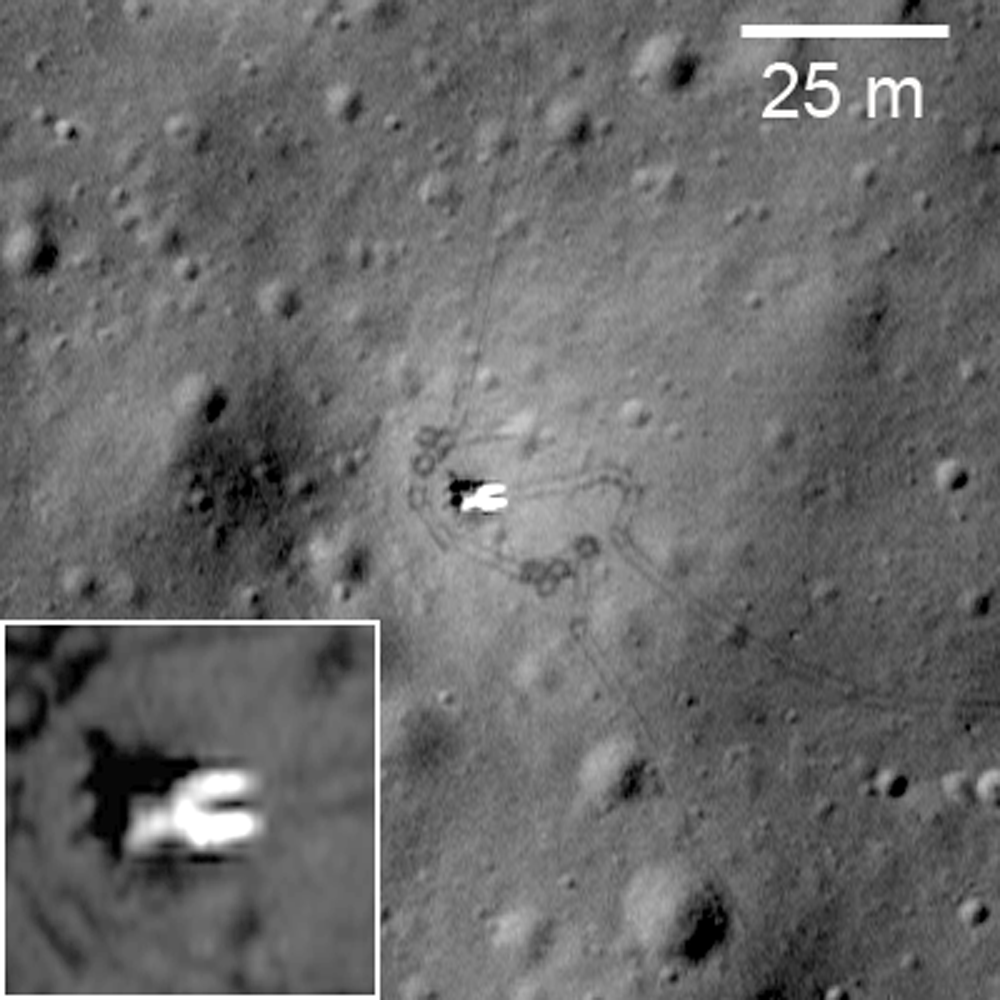
Luna 17, the lander that carried Lunokhod 1 to the surface; debarking ramps for the rover visible extending down to the surface to the right. Many rover tracks are visible around the lander and throughout LROC Narrow Angle Camera (NAC) frame M175502049RE, LRO orbit 10998, November 9, 2011. View the original contextual image with enlarged inset, HERE [NASA/GSFC/Arizona State University].
Olga Zakutnyaya
The Voice of Russia
 

A number of moon craters in the vicinity of Lunokhod–1 lunar rover have been given their own names. They were named in honor of the crew members of the first self-propelled vehicle on the surface of the celestial body.

The experiment carried out more than 40 years ago is to be repeated in the course of “Luna-Resource” expedition which should be launched no earlier than 2015.

The International Astronomical Union has approved 12 new names for small craters on the Moon, and now they have names of the members of the first lunar expedition and scientists who were involved in the project. Despite the fact that these people were not able to walk on the Moon’s surface themselves, they were the ones who led Lunokhod–1 – the first planet rover on the surface of an alien celestial body. All craters are located in the area of the “Sea of Rain” (Mare Imbrium) where the landing vehicle of Luna-17 interplanetary automatic station soft-landed in November 1970. It delivered Lunokhod lunar rover onto the Moon’s surface. All craters are comparatively small, their diameter ranging from 100 to 400 meters.

Thus, the names of Albert, Borya, Gena (in honor of the navigator Gabdulkhai Latypov), Igor, Kolya, Kostya, Leonid, Nikolya, Slava, Valera, Vasya, and Vitya appeared on the Moon.

The Luna-17 spacecraft was built by the design and construction bureau of the machine-engineering plant named after S.A. Lavochkin (now NPO Lavochkin). Lunokhod-1 was equipped with a set of scientific devices to explore the lunar soil. In the course of 10 months that it was working on the Moon, the rover traveled over 10.5 kilometers and sent back to Earth information about the mineral composition and characteristics of the lunar surface.

Lunokhod 1 rover in its final parking place (38.315°N, 324.992°E) on the surface of Mare Imbrium. LROC Narrow Angle Camera (NAC) observation M175502049RE, orbit 10998, November 9, 2011, resolution 33 cm per pixel. View original Featured Image released March 14, 2012 (with enlarged inset) HERE. [NASA/GSFC/Arizona State University].
Lunokhod-1 was controlled remotely via the center for space communications by two crews – five people each who worked in shifts. Each crew consisted of a commander, a driver, a navigator, a flight engineer, and a high gain antenna operator. Thus there were 10 people all together, plus a reserve driver and reserve high gain antenna operator.

Even though by the time Lunokhod-1 was launched American astronauts had already landed on the Moon, the soviet rover was no less a remarkable scientific and technical achievement. Unfortunately, at that time, the meaning of this achievement was overshadowed by the defeat in the race to put a man on the moon. Lunokhod-1, with all its novelty and complexity, was more of a consolation prize. At least that was the general attitude – and analysts might object, of course. Sadly, it was what determined the further development of the lunar program. After the improved version Lunokhod-2 in 1973, there was Lunokhod-3 which never made it to the Moon. As a result, the Lunar Program of the USSR was suspended. Forty years on there has been little progress.

Today it can be said that it was a mistake. Weak consolation might be the fact that space programs in other countries primarily in the United States have also been suspended. However, the comparison might not be accurate – paradoxically as it may sound as though the soviet moon explorations at the end of the “manned moon race” were in a better state (if not financially from the strategic point of view). A continuation of manned expeditions demanded huge resources and clear goals, which probably did not exist at that time. Autonomous expeditions were easier from the point of view of their preparation but brought back much more scientific results. Besides, by that time, complicated initial stages with lots of failures were overcome and so reliability was higher.

Far western 1970 Landing Zone of the Soviet Union's Luna 17, and the final parking spot of the first remote-operated lunar rover, Lunokhod-1. The French-built laser reflector array deployed from the Lunokhod eluded detection for four decades until its precise location was reacquired by the LROC Narrow Angle Camera in 2009. It's relocation added vital precision to measurements of the Earth-Moon distance that may answer important questions in astrophysics. LROC Wide Angle Camera 100 meter Global Mosaic overlaid upon LOLA topography and assembled using the NASA LMMP ILIADS application [NASA/GSFC/LMMP/Arizona State University].
Something similar is happening to NASA’s Mars exploration program. A long and ongoing exploration of the planet with more and more sophisticated and complex tasks resulted in the fact that the US became a true leader in the Mars programs. That was, in fact, the main argument by scholars who objected to cuts in NASA’s planetary space budget in 2013. In their opinion to lose such an important scientific and technical foundation would be a poor strategic move.

The current plans of Russia in the area of space exploration include returning to the Moon with landing vehicles and a mini-rover – a self-propelled machine which is being developed by an Indian organization for the purposes of the Luna-Resource program. It is planned to repeat lunar soil collection considering previous experiences. If in the course of the first expeditions the soil was collected only in the places of landing – now the goal is to combine the operation of the mini-rover and returning spacecraft. The mini-rover is to determine the most interesting spots and collect soil from them and then the spacecraft should return the samples to the Earth.

New Names Approved for Twelve Small Lunar Craters - The Working Group for Planetary System Nomenclature has approved 12 new names for small craters on the Moon: Albert, Borya, Gena, Igor, Kolya, Kostya, Leonid, Nikolya, Slava, Valera, Vasya, and Vitya. For details, see the map of LAC 24 and the Lunokhod-1 traverse map in the Gazetteer of Planetary Nomenclature [USGS].
Yet as of now these are only plans. Information from the Moon is coming daily. NASA LRO and GRAIL spacecraft continue to work in the Moon’s orbit (two spacecraft which measure lunar gravity fields). Several days ago, the NASA LRO mission published recent images of the lava fields formed as a result of asteroid impacts. The images were taken by LROC – Lunar Reconnaissance Orbiter Camera. This camera is also connected to the Lunokhods – in 2010, the first high resolution images were printed and it was possible to see Lunokhod-1 and the landing spacecraft and the wheel tracks. Interesting that in the same year a group of American scientists announced that they had managed to intercept a pulse from a laser retroreflector on Lunokhod-1.

It is probable that these circumstances have raised the interest in the Lunokhod program again. Naturally, recognition of the achievements of the soviet scientists is satisfying on the one hand, but on the other the interest is mostly coming from western institutions and space lovers. Without the LROC images, the “favourite lunar tractor” would be remembered only by those who are truly loyal to space science. That is why one of the tasks of the future lunar program is not only to learn again how to land and control spacecraft on the Moon, but also how to inform people about it in plain language, and on a regular basis.

Related: Lunokhod-1 revisited (March 15, 2012)

Friday, January 20, 2012

LROC Melt fractures in Jackson crater

Fractures can be seen in profuse abundance on the Jackson crater melt pond surface. Illumination from west, a field of view roughly 700 meters across swept up at an incidence angle of 71.13° LROC Narrow Angle Camera (NAC) observation M118560367L, LRO orbit 2606, January 19, 2010; resolution 0.84 meters from 52.97 kilometers altitude. View the full-size Featured Image HERE [NASA/GSFC /Arizona State University].
James Ashley
LROC News System

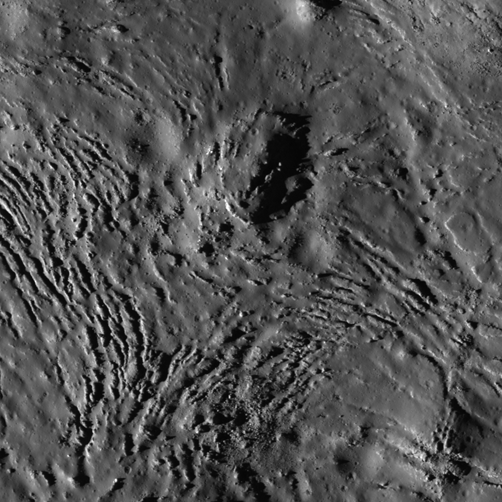
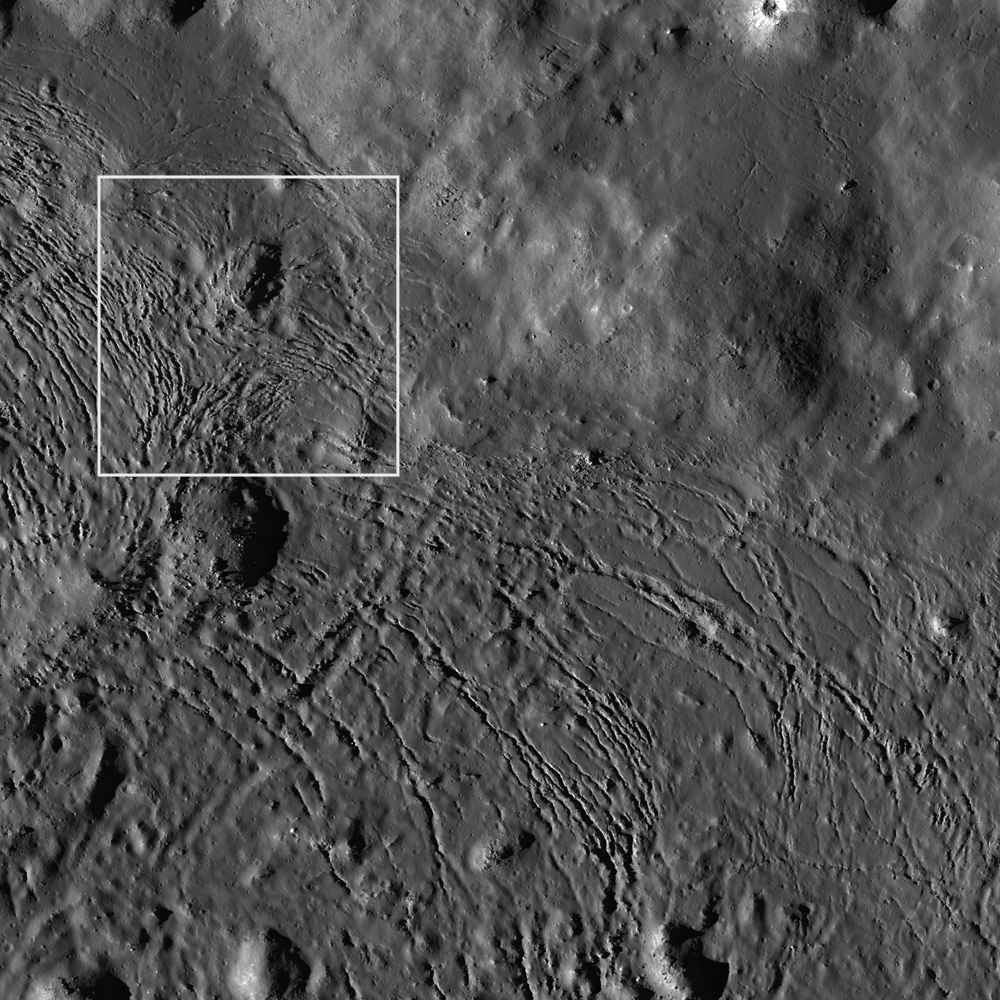
As molten rock cools, it shrinks and often cracks. In this case of impact melt ponded within the Jackson crater floor (22.18°N, 197.24°E), the cracking rate was so high that unfractured melt is almost more of an exception than a rule!

Radial and divergent patterns can be seen among the fracture sets that tell a story of the cooling history. The context image below shows a portion of their wider distribution.

As context for the January 18, 2012 LROC Featured Image (field of view near where the impact melt inundating the crater floor emerges from eastern wall slump; the white box) a long view north and up the steep northeastern wall, nearly to the rim, courtesy of the digital elevation model combined in Google Earth [NASA/USGS/ASU/JAXA/Google].
Overhead context for Featured Image, a field of view roughly 2.5 kilometers across from the wider LROC frame.View the full-size LROC context image HERE [NASA/GSFC/Arizona State University].
Solid objects in the melt, together with the 'shore' of the pond, appear to have influenced the way the cracks organized themselves as the melt cooled. Note how the fractures bend around or radiate from some of the positive relief features in the images above. These could be ejecta blocks or portions of the slumped crater walls in the melt that served to locally accelerate cooling. Their influence might thus be to 'seed' the stress field within the shrinking melt volume, helping some of the cracking to grow from these points, and ultimately resulting in the patterns we see today. Sagging along the shore can cause the cracking to parallel the shoreline. Any motion within the volume of melt, possibly influenced by late-stage additions of molten material, may also have contributed to the patterns observed here.

Further context, from 100 kilometers altitude, this square crop from a highly detailed HDTV still frame was captured by Japan's lunar orbiter SELENE-1 (Kaguya) in 2009 [JAXA/NHK/SELENE].
The extent and complexity of the melt pond features can be explored in the full NAC frame HERE. Additional examples of impact melt cracking include Polygonal fractures on Tycho ejecta deposits, fractured impact melt in Thales crater, and Moore F.

Ed Note: In a way opposite and contributing to the low optical visibility of the vast majority of similarly sized craters in the farside Highlands, Jackson is easier for the eye to see than most. Like Tycho on the nearside, there are a lot of craters of similar size and origin everywhere on the Moon. The difference is age. Like Tycho, the ray system of Jackson (and the materials its progenitor impact threw out) shows Jackson's "optical immaturity." To illustrate, below are two representations of the farside quadrant with the highest of the Highlands scoured by the Jackson impact, likely less than a half billion years ago.

Jackson stands out in this global montage of Clementine (1994) Ultra-Violet/Visible (UVVIS) wavelength photography designed to better map the Moon's albedo, more than a decade ago. Similar craters, basins and the Moon's highest elevations are nearly invisible [NASA/USGS/DOD].

A white arrow is needed to designate Jackson out from the pocked highlands and several otherwise invisible basins stand out with exceptional clarity in this view of nearly the same terrain as a representation of differences in elevation from the LROC Global Digital Terrain Model, developed using LROC Wide Angle Camera survey photography [NASA/GSFC/Arizona State University].

Friday, January 6, 2012

'Significant change' in bombardment timing

Among the things complicating the definitive dating of the familiar nearside basins is each shows signs of having been resurfaced more than once after their violent formation. Researchers progressed rapidly with secondary and primary crater counting and by retracing contours of topography based on the principle of superposition, that newer craters disrupt the old. Direct sampling allowed further for radio-isotope dating. Now high-resolution photography from LRO is allowing the reading of topography under nearly all lighting conditions. Painstaking analysis in years past has recently been renewed, suggesting a need for revision to the age of Serenitatis basin.
"A Significant change in our view of the impact process, and the history of the Earth-Moon system" is offered by three leading planetary scientists following a pain-staking analysis of LROC images of the eastern side of Mare Serenitatis.

Research by three eminent planetary scientists in the American Geophysical Union's Journal of Geophysical Universe will almost certainly cause a revision in generally accepted lunar timescale and ages for the Moon's most familiar basins. This is so primarily because the authors have had much to do with gathering the original evidence for the accepted dating over the past four decades. Based on high-resolution photography returned by the Lunar Reconnaissance Orbiter Camera their most recent work is filling gaps in tried and true methods for reading the story of the Moon (and the Solar System) engraved on the lunar surface.

The wide-ranging effect of the impact that formed Mare Imbrium has been obvious since the invention of the telescope. Just how widespread has been more difficult to determine. This LROC Wide Angle Camera (WAC) mosaic shows the mixed terrain of the Sulpicius Gallus area within and adjacent to the southwest corner of Mare Serenitatis basin. Radial grooving from Mare Imbrium (not shown), testifies clearly as to the violence unleashed by that basin-forming impact. Until very recently it was thought Serenitatis basin must have formed after the Imbrium event.  [NASA/GSFC.Arizona State University].
LROC WAC monochrome (643nm) observation M119645947ME, LRO orbit 2766, February 1, 2010. Astronauts Gene Cernan and Jack Schmitt explored the Taurus Littrow valley, in the hills southeast of Serenitatis in 1972. The forces that shaped South Massif (SM), North Massif (NM) and the Sculptured Hills (SH) were thought to have originated with the Serenitatis impact event. More recent study of LROC imagery, however, appears to show their near final form resulted from the Imbrium basin-forming impact [NASA/GSFC/Arizona State University].
The Taurus Littrow Valley, explored by Cernan and Schmitt of Apollo 17 (White Arrow, 1972) is a crossroads of lunar morphology immediately adjacent to the Serenitatis basin. Geologist astronaut Harrison "Jack" Schmitt, for example, confirmed his theory that the "Tortilla Flat" ray of material he and Capt. Cernan explored during their second EVA was radial to the 109 million year old "recent" Tycho crater.

At Shorty crater an abundance of orange regolith had been naturally excavated, offering evidence of ancient fire fountains deep in in the Moon's primeval past. Still, snuggled near the shore of Mare Serenitatis, it was far from certain if the Sculptured Hills and other mountains around the valley, indeed whether the valley itself, had been sculpted out originally by the force of the Serenitatis or the more distant Imbrium basin-forming impact.

During their third and final EVA, the last walk the Moon on December 13, 1972, Cernan and Schmitt had the opportunity to sample "Tracy's Rock," or 'Split Rock', a hefty boulder that had, at some point in the relatively recent past, rolled down the south-facing wall of North Massif where it partly broke apart near the valley floor. It offered an opportunity to analyze and sample part of the high mountains imaged almost four decades later from LRO.

Tracy's Rock - the split boulder that brought a significant sample of the Sculptured Hills-type mountains, in this case the North Massif down to the Taurus Littrow valley floor, where geologist astronaut Jack Schmitt and Apollo 17 commander Capt. Gene Cernan could sample it during the last walk on the Moon, December 13, 1972. At top, the same boulder heap is seen in LROC NAC observation M165645700RE, orbit 9545, July 18, 2011; resolution 47.7 cm per pixel from 40.6 kilometers [NASA/GSFC/Arizona State University].
Distinguished planetary geologist Don E. Wilhelms, retired from the U.S. Geological Service, Paul D. Spudis of the Lunar and Planetary Institute and LROC principal investigator Mark Robinson of Arizona State co-wrote the study published in late December. They conclude LRO imagery show the Serenitatis basin is relatively old, not young. 

Additionally, "an old Serenitatis means Apollo 17 impact melts may not date the Serenitatis basin," and either the late bombardment theory was less likely or the Moon's morphology is more poorly understood than is generally believed.

"New images from the Lunar Reconnaissance Orbiter Camera show the distribution and geological relations of the Sculptured Hills, a geological unit widespread in the highlands between the Serenitatis and Crisium basins. The Sculptured Hills shows knobby, undulating, radially textured and plains-like morphologies, and in many places is indistinguishable from the similarly knobby Valles Alpes formation, a facies of ejecta from the Imbrium basin.

"The new LROC image data show the Sculptured Hills in the Taurus highlands is Imbrium ejecta, not directly related to the formation of the Serenitatis basin. This occurrence and the geological relations of this unit suggest the Apollo 17 impact melt samples may not be not samples of the Serenitatis basin-forming impact, leaving their provenance undetermined and origin unexplained. If the Apollo 17 melt rocks are Serenitatis impact melt, then up to half the basin and a large crater population on the Moon was created within 30 million year interval around 3.8 billion years ago, in a global impact “cataclysm.”

"Either interpretation significantly changes our view of the impact process and history of the Earth-Moon system."

Abstract and Text (Subscription), HERE.
The Sculptured Hills of the Taurus Highlands:
Implications for the relative age of Serenitatis,
basin chronologies and the cratering history of the Moon
.
JOURNAL OF GEOPHYSICAL RESEARCH
VOL. 116, E00H03, 9 PP., 2011
doi:10.1029/2011JE003903

Wednesday, November 2, 2011

Tycho's flash-frozen inferno

Tycho in a full Sun, 'low phase' illumination, the crown jewel of a Full Moon on Earth has only its relative youth to distinguish it from many similarly-sized craters of similar origin. - LROC Wide Angle Camera (643 nm) mosaic from seven orbital passes (9061 - 9067) June 11, 2011. Arrow marks location of terraced pools of impact melt detailed below [NASA/GSFC/Arizona State University].
Joel Raupe
Lunar Pioneer, LLP

Hardly rare in scope or origin from similar craters all over the Moon, Tycho stands out like a bright star in the nearside southern Highlands because its bright rays radiate outward over the face of an entire Full Moon. Those rays make Tycho visible to the naked eye on Earth.

At a youthful 109 million years of age, relentless gardening by micrometerors has not yet smoothed the crater's reflective rougher edges, nor has a never-ending rain of charged particles, from the Sun and beyond, merged it's coloration into the background.Later impacts have not superimposed themselves or covered over the flash-frozen record of the mere minutes and hours following the explosive release of kinetic energy that created Tycho.

Tycho under 'high phase' illumination, at sunrise shows it's elevations in stark contrast, without the blinding albedo that tends to blur the immediate area of impact into the much broader area affected by that impact. LROC WAC mosaic, with longitude and latitude lines released by the LROC team last July. The impact melt detailed below, pooled just beyond the southeastern rim in this 130 kilometer-wide field of view, is much easier to see in the full-size original LROC image release, available HERE [NASA/GSFC/Arizona State University].
Among these finer details retained by Tycho are the pools of impact melt on the inner terraces and not far outside the crater's high rim, like the 'paved' pond Surveyor 7 nearly landed on in 1968, seen in the stark beauty of LROC Narrow Angle Camera observations.

The progenitor, the object that struck the lunar highlands and created Tycho threw up a lot of material in those first seconds afterward. Some of this material sped away at escape velocity, casually returning to the surface much later, if ever. Some sped away laterally as an immediate shock wave, carrying with it enough force to clip the tops of mountains on the south edge of Mare Serenitatis, knocking down the bright material of the Tortilla Flats in Taurus Littrow, sampled by Apollo 17 in 1972.

Some of the cloud scooped up by the blast hesitated above the area from where it was lifted and piled back down onto the surface outside the molten scar but most of the height where Tycho formed had to have been there before the explosion. We can tell this from the deep rutted channels carved into the highlands for hundreds of kilometers away from its center. The shape of the lunar surface around Tycho is not defined by what piled up but what remained after thousands of square kilometers of material were gouged away.

Tycho seems nested in a kind of plateau, though the evidence appears to show that this plateau was defined out of the highlands by the impact event that created Tycho. Great three and four kilometer-deep gullies appear to have been scooped out and away by the blast, better seen in this virtual 3D oblique view looking north over the outer southeastern rim of Tycho. LROC WAC (643 nm) mosaic as an overlay upon the Kaguya (SELENE-1) lunar digital elevation model in Google Earth [NASA/GSFC/USGS/JAXA/Arizona State University/Google].
The terraces on the inner walls of Tycho became a place for impact melt to pool and cool, so the terraces, by and large, were unlikely to have been formed by later slumping. We're left with a picture, immediately after the Tycho impact event, of a ragged scar, glowing hot in those first hours, from the central peak of deeper rock that rebounded in a heap (never higher than a crater's rim) to the very lip of the outer rim. It must have been a scene right out of Dante's Inferno.

LROC Wide Angle Camera (WAC) monochrome (643 nm) observation M119950214M, LRO Orbit 2810, February 4, 2010; resolution 66.12 meters per pixel, incidence angle 64.73° from 47.55 km. The yellow rectangle roughly outlines the field of view within the entire from of the LROC Narrow Angle Camera (NAC) frame from which scenes following originated [NASA/GSFC/Arizona State University].
Zooming in on these "Southeast Tycho" impact melt ponds, in the images above and following, note the fan of these ponds seem to flow downhill from a particularly ragged spot on the rim and apparently from further north channeled from an less distinct portion of the circumference of Tycho's rim. It's hard to imagine Tycho filled to the "brim" with molten rock, though the original melt was probably higher before it solidified to its present level. 

It's easier to imagine very hot material briefly pasted on the inside walls of Tycho sliding down to pool and form the ponds on the inner wall terraces. The ponds on the outside of Tycho are relatively sparse, but so is the slope acreage elevations outside the crater's interior. Before the anatomy of Tycho cooled and hardened some of the hottest melt was slung high seems to have collapsed like the opening rip of an ocean wave, which quickly froze, liquid rock that fossilized forty million years before the KT Boundary Extinction event brought an end to the Age of Dinosaurs here on Earth.

As impact melt briefly ran down the exterior side of the southeast brim of Tycho and pooled, coming to a halt in the cold vacuum of space long before 'finding its own level,' what appear as grooves formed by flowing molten material appear closer in to be shattered rock that instead merely aided molten transport. LROC NAC observation M150578086R, LRO Orbit 7324, January 25, 2011; resolution 71 centimeters per pixel, incidence angle 69.84° from 44.74 kilometers [NASA/GSFC/Arizona State University].
Full resolution view of the pond shore at the upper northeast in the image immediately above. The impact melt that ponded here briefly 109 million years ago was still hot enough for gas trapped within to heave bubbles to its surface. The flow at this juncture was arriving from all direction and the rounded surface tension elsewhere testifies to the lava-like viscosity of the pond [NASA/GSFC/Arizona State University].
A second full-resolution view from LROC NAC M150578086R shows where melt from the Tycho event briefly flowed down a huge, powerful fall at a high slope between ponds more than a thousand meters apart in elevation [NASA/GSFC/Arizona State University].
Tycho may be the same as many other craters on the Moon, but it's relative youth "in Moon years" makes it an easy choice for mapping the immediate aftermath of a powerful impact on an airless body, at least for the next half billion years or so.

Related Posts:
Tycho Peak Spectacular!
Chaotic crater floor in Tycho
Polygonal fractures on Tycho ejecta
Impact melt on Tycho floor
Ejecta on Tycho floor