Showing posts with label M3. Show all posts

Tuesday, January 21, 2014

Clementine - The Legacy, Twenty Years On

Engineering model of the Clementine spacecraft in the Lunar Exploration Vehicles exhibit at the National Air and Space Museum. Interstage and solid rocket motor (bottom half) was discarded before insertion into lunar orbit.
Paul D. Spudis
Smithsonian Air & Space

The first spacecraft to globally map the Moon left lunar orbit on May 3, 1994.  Clementine, a joint Department of Defense-NASA mission, had systematically mapped the Moon’s surface over 71 days, collecting almost 2 million images.  For the first time, scientists could put results of the Apollo lunar sample studies into a regional, and ultimately, a global context.  Clementine collected special data products, including broadband thermal, high resolution and star tracker images for a variety of special studies.  But in addition to this new knowledge of lunar processes and history, the mission led a wave of renewed interest in the processes and history of the Moon, which in turn, spurred a commitment to return there with both machines and people.  We peeked into the Moon’s cold, dark areas near the poles and stood on the edge of a revolution in lunar science.

Prior to Clementine, good topographic maps only existed for areas under the ground tracks of the orbital Apollo spacecraft.  From Clementine’s laser ranging data, we obtained our first global topographic map of the Moon.  It revealed the vast extent and superb preservation state of the South Pole-Aitken (SPA) basin and confirmed many large-scale features mapped or inferred from only a few clues provided by isolated landforms.  Correlated with gravity information derived from radio tracking, we produced a map of crustal thickness, thereby showing that the crust thins under the floors of the largest impact basins.

Two cameras (with eleven filters) covered the spectral range of 415 to 1900 nm, where absorption bands of the major lunar rock-forming minerals (plagioclase, pyroxene and olivine) are found.  Varying proportions of these minerals make up the suite of lunar rocks.  Global color maps made from these spectral images show the distribution of rock types on the Moon.  The uppermost lunar crust is a mixed zone, where composition varies widely with location.  Below this zone is a layer of nearly pure anorthosite, a rock type made up solely of plagioclase feldspar (formed during the global melting event that created the crust).  Craters and large basins act as natural “drill holes” in the crust, exposing deeper levels of the Moon.  The deepest parts of the interior (and possibly the upper mantle) are exposed at the surface within the floor of the enormous SPA basin on the far side of the Moon.

Topographic map of the Moon made from Clementine laser altimetry in mid-latitudes and stereo images near the poles. Large depression in southern far side is the South Pole-Aitken basin.
Clementine showed us the nature and extent of the poles of the Moon, including peaks of near permanent sun-illumination and crater interiors in permanent darkness.  From his first look at the poles, Gene Shoemaker (Leader of the Clementine Science Team) got an inkling that something interesting was going on there.  Gene was convinced that water ice might be present, an idea about which I had always been skeptical.  At that time, no trace of hydration had ever been found in lunar minerals and the prevailing wisdom was that the Moon is now and always had been bone dry.  With Gene arguing to keep an open mind and Stu Nozette (Deputy Program Manager) devising a bistatic radio frequency (RF) experiment to use the spacecraft transmitter to “peek” into the dark areas of the poles, we moved ahead on planning the observations.

To my astonishment (and delight), a pass over the south pole of the Moon showed evidence for enhanced circular polarization ratio (CPR) – a possible indicator of the presence of ice.  A control orbit over a nearby sunlit area showed no such evidence.  However, CPR is not a unique determinant for ice, as rocky, rough surfaces and ice deposits both show high CPR.  It took a couple of years to reduce and fully understand the data, but collection of the bistatic collection was successful.  In part, our ice interpretation was supported by the discovery of water ice at the poles of Mercury (a planet very similar to the Moon).  We published our results in Science magazine in December 1996, setting off a media frenzy and a decade of scientific argument and counter-argument about the interpretation of radar data for the lunar poles (an argument that continues to this day, despite subsequent confirmation of lunar polar water from several other techniques).

Along with Clementine’s success came a growing interest in lunar resources and a new appreciation for the complexity of the Moon.  This interest led to the selection of Lunar Prospector (LP) as the first PI-led mission of NASA’s new, low-cost Discovery series of planetary probes.  LP flew to the Moon in 1998 and carried instruments complementary to the data produced by Clementine, including a gamma-ray spectrometer to map global elemental composition, magnetic and gravity measurements, and a neutron spectrometer to map the distribution of hydrogen.  LP found enhanced concentrations of hydrogen at both poles, again suggesting that water ice was probably present.  The debate on the abundance and physical nature of the water ice continued, with estimates ranging from a simple enrichment of solar wind implanted hydrogen in polar soils, to substantial quantities of water ice trapped in the dark, cold regions of the poles.

Buttressed by this new information, the Moon became an attractive destination for robotic and human missions.  With direct evidence for significant amounts of hydrogen (regardless of form) on the surface, there now was a known resource that would support long-term human presence.  This hydrogen discovery was complemented by the identification in Clementine images of several areas near the pole that remain sunlit for substantial fractions of the year – not quite the “peaks of eternal light” first proposed by French astronomer Camille Flammarion in 1879 but something very close to it.  The availability of material and energy resources  – the two biggest necessities for permanent human presence on the Moon – was confirmed in one fell swoop.  Combined, the results of Clementine and LP finally gave scientists the Lunar Polar Orbiter mission we had long sought.  These two missions certified the possibility of using lunar resources to provision ourselves in space, permanently establishing the Moon as a valuable, enabling asset for human spaceflight.  Remaining was to verify and extend the radar results from Clementine and map the ice deposits of the poles.

The Clementine bistatic experiment led to the development of an RF transponder called Mini-SGLS (Space Ground Link System), which flew on the Air Force mission MightySat II in 2000.  This experiment miniaturized the RF systems necessary for a low mass, low power imaging radar.  With the 2008 inclusion of our Mini-SAR on India’s Chandryaan-1 lunar orbiter, we finally got the chance to build and fly such a system.  Chandrayaan-1 not only mapped the high CPR material at both poles, it also carried a spectrometer (the Moon Mineralogy Mapper, or M3) that discovered large amounts of adsorbed surface water (H2O) and hydroxyl (OH) at high latitudes.  Coupled with the measurement of exospheric water above the south pole by its Moon Impact Probe, Chandrayaan-1 significantly advanced our understanding of polar water, revealing it to be abundant and present in more varied forms on the Moon than had previously been imagined.

Mosaic of Clementine images of the south pole of the Moon. Dark regions contain water ice and small areas near pole are sunlit for significant fractions of the lunar day.
The ever increasing weight of evidence for the presence of significant amounts of water at the lunar poles led to the LCROSS experiment being “piggybacked” on NASA’s 2008 Lunar Reconnaissance Orbiter (LRO) mission.  LCROSS was a relatively inexpensive add-on, designed to observe the collision of the LRO launch vehicle’s Centaur upper stage with the lunar surface, looking for water in the ejecta plume of that impact.  Water in both vapor and solid form was observed, suggesting the presence of water ice in the floor of the crater Cabaeus (at concentration levels between 5 and 10 weight percent).  LRO orbits the Moon and collects data to this day.  Although much remains unknown about lunar polar water, we now know for certain that it exists; such knowledge has completely revised our thinking about the future use and habitation of the Moon.

The Clementine programmatic template has influenced spaceflight for the last 20 years.  The Europeans flew SMART-1 to the Moon in 2002, largely as a technology demonstration mission with goals very similar to those of Clementine.  NASA directed the Applied Physics Laboratory (APL) to fly Near-Earth Asteroid Rendezvous (NEAR) to the asteroid Eros in 1995 as a Discovery mission, attaining the asteroid exploration opportunity missed when control of the Clementine spacecraft was lost after leaving the Moon.  India’s Chandrayaan-1 was of a size and payload scope similar to Clementine.  The selection of LCROSS as a low-cost, fast-tracked, limited objectives mission further extended use of the Clementine paradigm.

The “Faster-Better-Cheaper” mission model, once panned by some in the spaceflight community, is now recognized as a preferred mode of operations, absent the emotional baggage of that name.  A limited objectives mission that flies is more desirable than a gold-plated one that sits forever on the drawing board.  While some missions do require significant levels of fiscal and technical resources to attain their objectives, an important lesson of Clementine is that for most scientific and exploration goals, “better” is the enemy of  “good enough.”  Space missions require smart, lean management; they should not be charge codes for feeding the beast of organizational overhead.  Clementine was lean and fast; perhaps we would have made fewer mistakes had the pace been a bit slower, but overall the mission gave us a vast, high-quality dataset, still extensively used to this day.  The Naval Research Laboratory transferred the Clementine engineering model to the Smithsonian in 2002.  The spacecraft hangs today in the Air and Space Museum, just above the Apollo Lunar Module.

It is probably not too much of an exaggeration to say that Clementine changed the direction of the American space program.  After the failure of SEI in 1990-1992, NASA was left with no long-term strategic direction.  For the first time in its history, NASA had no follow-on program to Shuttle-Station, despite attempts by Dan Goldin and others to secure approval for a human mission to Mars (then and now, a bridge too far – both technically and financially).  This programmatic stasis continued until 2003, when the tragic loss of Columbia led to a top-down review of U.S. space goals.  Because Clementine had documented its strategic value, the Moon once again became an attractive destination for future robotic and human missions.  The resulting Vision for Space Exploration (VSE) in 2004 made the Moon the centerpiece of a new American effort beyond low Earth orbit.  While Mars was vaguely discussed as an eventual (not ultimate) objective, the activities to be done on the Moon were specified in detail in the VSE, particularly with regard to the use of its material and energy resources to build a sustainable program.  Regrettably, various factors combined to subvert the Vision, thereby ending the strategic direction of America’s civil space program.

Clementine was a watershed, the hinge point that forever changed the nature of space policy debates.  A fundamentally different way forward is now possible in space – one of extensibility, sustainability and permanence.  Once an outlandish idea from science fiction, we have found that lunar resources can be used to create new capabilities in space, a welcome genie that cannot be put back in the bottle.  Americans need to ask why their national space program was diverted from such a sustainable path.  We cannot afford to remain behind while others plan and fly missions to understand and exploit the Moon’s resources.  Our path forward into the universe is clear.  In order to remain a world leader in space utilization and development – and a participant in and beneficiary of a new cislunar economy – the United States must again direct her sights and energies toward the Moon.

Note: Background history for the Clementine mission is described in a companion post at my Spudis Lunar Resources blog, HERE.

Originally published at his Smithsonian Air & Space blog The Once and Future Moon, Dr. Spudis is a senior staff scientist at the Lunar and Planetary Institute. The opinions expressed are those of the author but are better informed than average.

Wednesday, October 16, 2013

Measuring almost nothing, looking for the almost invisible

hdtv_010_4_l-580x1080
NASA's LADEE spacecraft entered it's 250 km Commissioning phase orbit October 12 [NASA/JAXA].
Paul D. Spudis
The Once and Future Moon
Smithsonian Air & Space

Launched last month from the Wallops Island site, LADEE (for Lunar Atmosphere and Dust Environment Explorer) will spend the next few months orbiting the Moon.  This small spacecraft will attempt to characterize and measure the lunar “atmosphere,” while also looking for dust that might be electrostatically levitated above the surface or thrown into ballistic flight by impacts.

Wait a minute.  Did I say “atmosphere?”  Isn’t the Moon renowned for its lack of an atmosphere?  Indeed it is.  In fact, the 10-12 torr surface pressure of the Moon is a better vacuum than we can achieve with even the most advanced equipment in Earth laboratories.  (For comparison, sea level pressure on the Earth is about 760 torr, making the lunar surface pressure over one hundred trillion times less dense.)  A better term for the tenuous gas near the Moon is “exosphere,” meaning free flying gas molecules that may or may not be gravitationally bound to the Moon.  In such an “atmosphere,” there may be only a few thousand molecules in a cubic centimeter of space. This is very tenuous indeed.
  
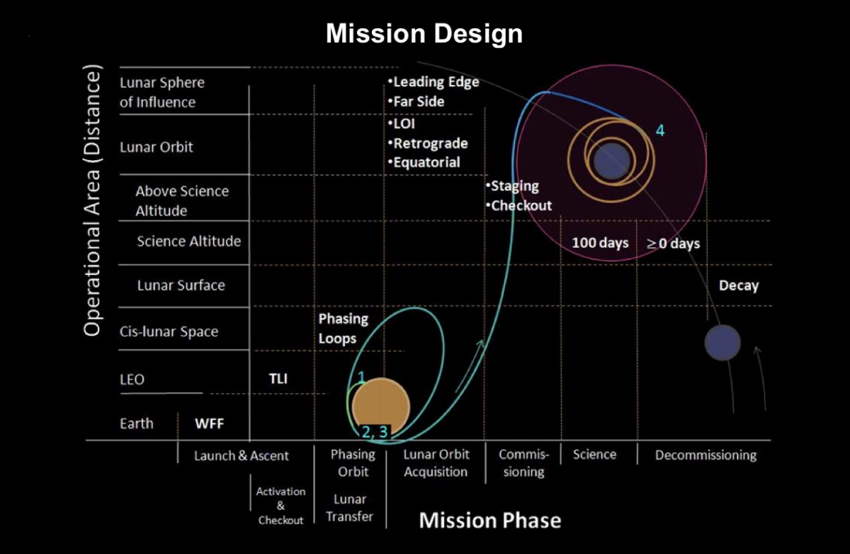
After the Commissioning phase of its mission is complete, the spacecraft's current 250 km circular orbit will be reduced further down to within 50 km to begin its 100 day Science Mission [NASA/GSFC].
LADEE is designed to investigate from where these atoms and molecules come.  Presently, we think the lunar exosphere consists mostly of helium, sodium and perhaps argon atoms, each coming from a completely different source.  Helium likely comes from the Sun, as the solar wind continually “breathes” onto the surface of the Moon.  Some atoms stick to surface dust grains but many simply bounce off, randomly moving in the space above the lunar surface.  Easy to detect, lunar sodium has been observed from Earth-based telescopes.  It most likely comes from rocks vaporized by the continual rain of micrometeorites.  At least some fraction of this vaporous sodium must hang around the surface, unable to escape the Moon.  Argon might have a solar wind origin, but at least some of it comes from the natural decay of radioactive potassium in the lunar interior (potassium-40 (40K) decays to argon-40 (40Ar) with a half-life of a bit more than one billion years).  Gases like argon, venting from the interior of the Moon, were observed by subsatellites left in lunar orbit by the departing Apollo spacecraft over 40 years ago (these small spacecraft have long since crashed into the Moon).

Although helium, sodium and argon are the principal expected components of the lunar exosphere, the LADEE team will search for other species.  An interesting possibility is water (H2O) or its related species, hydroxyl (OH).  One of the most surprising results of recent lunar exploration was the discovery of adsorbed (surface) water and hydroxyl on the dust grains of the lunar surface (observed by the Moon Mineralogy Mapper (M3) aboard the Indian Chandrayaan-1 lunar orbiter in 2009).  Occurring in the form of a monolayer of molecules on dust grains in the cooler portions of the Moon, a clear water signal is best seen above latitudes of 65° and increasing in strength (i.e., increasing water abundance) toward each pole.

The surprise from M3 was not only the presence of water but observing that its abundance increases with decreasing surface temperatures.  This means that water being made or deposited on the surface is in motion, with a net movement toward the poles.  Chandrayaan-1 also carried an impact probe with a mass spectrometer.  During the probe’s half-hour descent to the South Pole, it passed through a cloud of water in space, just above the lunar surface.  The water cloud at this high latitude had a density a hundred times higher than at the equator, providing additional evidence that exospheric water is in motion, moving from lower, hotter latitudes towards higher, cooler ones.

LADEE cannot directly measure this water in a neutral state, but if some process ionizes it (e.g., if a water molecule breaks apart into a proton and a hydroxyl by UV radiation from the Sun), it will be visible to the ultraviolet spectrometer aboard the spacecraft.  If the process of water migration on the lunar surface is correct, we should be able to observe exospheric water and by measuring its density with time, track the water migration to higher latitudes.

Lunar Horizon Glow (LHC) observed for several hours following local sunset from Surveyor 7 and its landing site just north of Tycho crater. [NASA].
LADEE will also tackle another controversial issue – the amounts and mechanisms of dust movement on and around the Moon.  During the unmanned Surveyor lander missions over 40 years ago, a strange illumination or glow was observed by television for several hours after local sunset, just above the horizon.  This phenomenon was termed “horizon glow” by surprised Surveyor investigators.  At a loss to explain it, the team postulated that some mechanism was lofting dust up above the surface and this dust was scattering sunlight.  Exactly how the dust was lofted was uncertain; some thought it must be fragments in ballistic flight from distant impacts, while others thought that it might be levitated by electrostatic force, thus “hovering” above the surface.

Schematic of documented species of Lunar Horizon Glow, including mid-lunar night imagery captured by Surveyor 7 (Horanyi, et.al., The Lunar Dust Environment: Expectations for the LADEE Lunar Dust Experiment (LDEX), 43rd Lunar and Planetary Science Conference (2012), #2635.
A few years later, just before his orbiting spacecraft emerged into the daylight side of the Moon, Apollo 17 Commander Gene Cernan observed and sketched an illuminated limb and “streamers” that could be seen extending into space above where the lunar horizon would be.  At the time, this phenomenon was thought to be the same as that seen in the Surveyor pictures, although they have totally different scales (the Surveyor horizon glow must occur within a few meters of the surface, while Cernan’s horizon glow extended many kilometers above the Moon). Dust (probably of lunar provenance) is certainly involved in whatever causes this horizon glow.

Apollo 17 commander Gene Cernan's sketches and description of horizon glow and streamers observed in lunar orbit, December 1972 [NASA].
As the Moon slowly rotates once every 708 hours, the line between the sunlit and dark hemispheres (the terminator) slowly moves across the lunar surface.  The day and night hemispheres have different fluxes of electrons from the solar wind and thus, the presence of the terminator can induce an electrical charge in surface materials.  It is postulated that this charge might levitate smaller dust particles such that they would hover above the surface.  LADEE will attempt to detect and map this dust, both by searching for scattered sunlight with its ultraviolet spectrometer and via the direct detection of dust particles in flight with an instrument on the top of the orbiting spacecraft.

The issue of levitated dust is thought to be relevant to the future habitation of the Moon.  If dust is lofted above the surface by the passage of the terminator, the particles could degrade clean surfaces and create a hazard for inhabitants of the Moon.  Such a process could have major effects near the poles of the Moon, areas that are in the near-constant presence of a day-night terminator.  Although it is unlikely that levitated dust on the Moon is an environmental hazard, we currently are working in near total absence of hard data.  Thus, it makes sense to at least try to make some direct measurements of the dust environment around the Moon to assess the importance of this proposed surface process.

LADEE arrived in lunar orbit last Sunday. We wish it well on its mission to give us fresh (and welcome) data on a poorly understood aspect of lunar processes and history.

Related Posts:
LADEE, in 250 km orbit, begins commissioning phase (October 15, 2013)
LADEE Away! (September 7, 2013)
LADEE legacies (September 7, 2013)
LADEE Prelaunch Mission Briefing (September 6, 2013)
ESA prepares for LADEE (July 31, 2013)
LADEE arrives at Wallops Island (June 5, 2013)
LADEE ready to baseline dusty lunar exosphere (June 5, 2013)
First laser comm system ready for launch on LADEE (March 16, 2013)
LADEE project manager update (February 6, 2013)
The Mona Lisa test for LADEE communications (January 21, 2013)
Toxicity of lunar dust (July 2, 2012)
Expectations for the LADEE LDEX (March 23, 2012)
The Dust Management Project (August 9, 2010)
LADEE architecture and mission design (July 6, 2010)
DesertRatS testing electrodynamic dust shield (July 5, 2010)
Dust transport and its importance in the origin of lunar swirls (February 21, 2010)
Dust accumulation on Apollo laser reflectors may indicate a surprisingly fast and
   more dynamic lunar exosphere
(February 16, 2010)
NASA applies low cost lessons to LADEE (January 18, 2010)
Nanotech advances in lunar dust mitigation (August 19, 2009)
Moon dust hazard influenced by Sun's elevation (April 17, 2009)
LADEE launch by Orbital from Wallops Island (April 14, 2009)
Understanding the activation and solution properties of lunar dust
for future lunar habitation
(March 2, 2009)
Respiratory toxicity of lunar highland dust (January 19, 2009)
Toxicological effects of moon dust (June 25, 2008)
Moon dust and duct tape (April 22, 2008)

Originally published October 4, 2013 at his Smithsonian Air & Space blog The Once and Future Moon, Dr. Spudis is a senior staff scientist at the Lunar and Planetary Institute. The opinions expressed are those of the author but are better informed than average.  

Tuesday, August 27, 2013

More water at lunar equator, hints of water below

Bullialdus Interior Oblique
Investigations of the central peaks (where the deepest material these kinds of craters excavate is deposited) of nearside equatorial crater Bullialdus (60.7 km, 20.7°S, 337.8°E) have detected rocks composed of magmatic water of a kind collected by Apollo using the NASA M3 radar instrument aboard the ISRO orbiter Chandrayaan-1. LROC Narrow Angle Camera (NAC) oblique observation M1099038207LR, spacecraft orbit 14313, August 8, 2012; overall resolution 2.4 meters, angle of incidence 48.8° with spacecraft and camera slewed 63.4° west of nadir, 73.65 kilometers over 20.96°S, 331.93°E [NASA/GSFC/Arizona State University].
NASA-funded lunar research has yielded evidence of water locked in mineral grains on the surface of the moon from an unknown source deep beneath the surface.

Using data from NASA's Moon Mineralogy Mapper (M3) instrument aboard the Indian Space Research Organization (ISRO) Chandrayaan-1 spacecraft, scientists remotely detected magmatic water, or water that originates from deep within the moon's interior, on the surface of the moon.

The findings, published by letter, August 25, in Nature Geoscience, represent the first detection of this form of water from lunar orbit. Earlier studies had shown the existence of magmatic water in lunar samples returned during the Apollo program.

M3 imaged the lunar impact crater Bullialdus, which lies near the lunar equator. Scientists were interested in studying this area because they could better quantify the amount of water inside the rocks due to the crater's location and the type of rocks it held. The central peak of the crater is made up of a type of rock that forms deep within the lunar crust and mantle when magma is trapped underground.

"This rock, which normally resides deep beneath the surface, was excavated from the lunar depths by the impact that formed Bullialdus crater," said Rachel Klima, a planetary geologist at the Johns Hopkins University Applied Physics Laboratory (APL) in Laurel, Maryland.

"Compared to its surroundings, we found that the central portion of this crater contains a significant amount of hydroxyl - a molecule consisting of one oxygen atom and one hydrogen atom -- which is evidence that the rocks in this crater contain water that originated beneath the lunar surface," Klima said.

LROC Wide Angle Camera (WAC) 100 meter per pixel mosaic of Bullialdus, an illustration for the post "Bullialdus Central Peak Oblique," January 23, 2013 [NASA/GSFC/Arizona State University].
In 2009, M3 provided the first mineralogical map of the lunar surface and discovered water molecules in the polar regions of the moon. This water is thought to be a thin layer formed from solar wind hitting the moon's surface. Bullialdus crater is in a region with an unfavorable environment for solar wind to produce significant amounts of water on the surface.

"NASA missions like Lunar Prospector and LCROSS (the Lunar Crater Observation and Sensing Satellite) and instruments like M3 have gathered crucial data that fundamentally changed our understanding of whether water exists on the surface of the moon," said S. Pete Worden, center director at NASA's Ames Research Center in Moffett Field, Calif. "Similarly, we hope that upcoming NASA missions such as the Lunar Atmosphere and Dust Environment Explorer, or LADEE, will change our understanding of the lunar sky."

Combined data for the Bullialdus area
Figure 5 from "One Moon, Many Measurements 3: Spectral reflectance," Science Direct (Icarus, Vol 226, #1, Sept.-Oct. 2013) Combined data for the Bullialdus area. (a) Location of available datasets of the Bullialdus region: gray scale base map, MI; red dots, SP traverses; blue shading, M3 scene width; light-blue dots, SIR-2 traverses. SP/M3/SIR-2 datasets within the white box are presented in this figure. The white box corresponds to the area shown in (b) and (c). TC data cover the entire area. Data included in Table 2 for SP are indicated in yellow, and those for SIR-2 are solid light blue. (b) M3 color-composite image. Band assignments are integrated band depth at 1 μm (red), integrated band depth at 2 μm (green), and 1.5 μm albedo (blue). A manual shadow mask has been applied, primarily on the west (left) crater wall. (c) MI color-composite image. Red denotes the continuum-removed absorption depth of 0.95 μm, green denotes that of 1.05 μm, and blue denotes that of 1.25 μm. (d) TC image of the central part of the Bullialdus central peak. (e) MI 750 nm-band image after photometric correction using local topographic information. (f) MI color-composite image of the center of the Bullialdus central peak. (For interpretation of the references to color in this figure legend, the reader is referred to the web version of this article.)

The detection of internal water from orbit means scientists can begin to test some of the findings from sample studies in a broader context, including in regions that are far from where the Apollo sites are clustered on the near side of the moon. For many years, researchers believed that the rocks from the moon were bone-dry and any water detected in the Apollo samples had to be contamination from Earth.

"Now that we have detected water that is likely from the interior of the moon, we can start to compare this water with other characteristics of the lunar surface," said Klima. "This internal magmatic water also provides clues about the moon's volcanic processes and internal composition, which helps us address questions about how the moon formed, and how magmatic processes changed as it cooled."

APL is a not-for-profit division of Johns Hopkins University. Joshua Cahill and David Lawrence of APL and Justin Hagerty of the U.S. Geological Survey's Astrogeology Science Center in Flagstaff, Arizona co-authored the paper.

NASA's Lunar Advanced Science and Engineering Program, the NASA Lunar Science Institute (NLSI) at Ames and the NASA Planetary Mission Data Analysis Program supported the research. NLSI is a virtual organization jointly funded by NASA's Science Mission Directorate and NASA's Human Exploration and Operations Mission Directorate in Washington, to enable collaborative, interdisciplinary research in support of NASA lunar science programs.

Saturday, October 8, 2011

It's a gas, man

"Ina," (18.65°N, 5.3°E) an extremely young and unusual 3 by 2 km depression that may represent a gas eruption site on the Moon. LROC Narrow Angle Camera (NAC) observation M119815703, LRO orbit 2791, February 3, 2010 [NASA/GSFC/Arizona State University]

Paul D. Spudis
The Once and Future Moon
Smithsonian Air & Space

There are times when seemingly unrelated discoveries about other planets come forward to enlighten us about the history and processes of the Moon. A recent paper, using data from the orbiting MESSENGER mission mapping Mercury, describes a number of newly discovered rimless pits and depressions.  These pits (called hollows by the mission team) are difficult to explain by impact processes and are hypothesized to be the products of outgassing from the planet’s interior.  They are often associated with color anomalies (which implies compositional differences from the surrounding terrain) and frequently found on the floors of impact craters and basins.

Impact craters come in a wide variety of sizes, but within selected size ranges, they all appear more or less similar.  Small craters are nearly perfectly round and bowl-shaped with smooth rims that are raised above the surrounding terrain.  Craters with irregular shapes and no raised rims suggest that processes other than impact might be at work.  It has been suggested that on Mercury, these “hollows” were created by the violent release of volatile substances.  Such a release of gas under pressure accompanies volcanic eruptions called pyroclastic, meaning “fire-broken” (fine liquid rock (magma) fragments spewed into space and cooled during flight).

We’ve known about pyroclastic eruptions on the Moon for many years, evidenced by the green glass of the Apollo 15 site and the orange-black glass from Apollo 17.  Careful search of the images taken from lunar orbit reveal the rimless pits that served as vents for the pyroclastic eruptions that produced these Apollo glasses.  They are distinct from impact craters and often are found on the floors of craters and basins along fractures, the conduit by which volcanic magma travels to the lunar surface.

Sometimes pit craters or “hollows,” found across the surface of the Moon, take unusual form.  The kidney-shaped feature shown above is named Ina; after its discovery in one of the Apollo orbital images, it was informally named the “D-caldera” after its shape and the interpretation that it represented a volcanic collapse feature.  Ina is about 3 km across and consists of a series of small platforms, mounds and holes within a larger irregular depression.  Other similar pits and hollows occur elsewhere on the Moon (e.g., on the floor of Rima Hyginis).  And while not major features, they have been found often enough to bother many lunar scientists, who had no good explanation for their origin.

About five years ago, we got a clue as to the possible origins of these features.  Pete Schultz and associates from Brown University published a paper showing Ina displayed unusual spectral reflectance characteristics.  The slow micrometeorite bombardment of the Moon adds craters to the surface and also makes small iron-rich glass particles that darken and redden the surface.  As these glass particles build up in the soil, a soil is said to “mature.”  Fresh surfaces are more “blue” in color (actually, less red) and become redder with time as the soil matures.  Most lunar features show age or “become mature” on timescales of millions of years.  Ina shows very few impact craters on top of it, meaning that geologically, it is very young.  Moreover, the soils associated with Ina are much bluer than surrounding areas.  Both of these observations suggest that Ina is young with immature surfaces.

Perspective view of Ina looking NW based on coaligned M3,
Kayuga and LOLA topographic data. Bright optically immature
deposits on the floor of Ina appear green in this M3
(Chandrayaan-1) color-ratio composite due to a strong 1 m ferrous
band relative to surrounding deposits (B=460/750, G=750/990,
R=750/460) [Fig. 3 from LPSC XLII, #2499].
How are these features created?  Significant volcanism on the Moon largely stopped at least a couple of billion years ago.  The Brown team thought that the combination of young age, low maturity and unusual morphology suggested a relatively uncommon pit-forming process.  They proposed that the explosive release of volatile substances from the lunar interior would have disrupted the surface, created a chaotic mixture of rock and soil, exposed fresh surfaces (creating the immature spectral signature), and formed a collapse depression caused by the instantaneous removal of mass from below.

Now we can see that the new Mercurian hollows have morphologies displaying spectral anomalies similar to the lunar collapse pits such as Ina.  The new data suggest that Mercury contains significant volatile substances.  These volatiles must be present at some depth, accumulated under high pressure until crustal failure ensues and a massive gas release results in an “eruption.”  This explosive event leaves behind a chaotic, disrupted surface (“immature,” with fresh bedrock and deep regolith “newly” exposed to space).

In the case of Ina on the Moon, its extreme youth is suggested both by the lack of overlying impact craters of almost any size, as well as the sharp preservation of topography in its cliff and pit interior morphology.  This extreme youth may be on the order of thousands to hundreds of thousands of years, not the millions and billions of years that typify most lunar landforms.  Such youth and the widespread distribution of Ina-like collapse pits across the lunar surface implies that outgassing events are occurring on the Moon now; it is highly unlikely that we were just lucky enough to find a singular or unique occurrence.

For context and depth of field, Ina is shown prior to local sunset north of Mare Vaporum, in this roughly 46 kilometer wide LROC Wide Angle Camera (WAC) color (689 nm) mosaic stitched from two sequential observation opportunities, from LRO orbits 2443 and 2444, January 6, 2010. Down slope from the feature, to the east by southeast, younger surface material may be a hint of pyroclastic flow [NASA/GSFC/Arizona State University].
What might these volatile substances be?  Before the recent lunar missions flew, it was common to declare that water was not a possibility.  However, we recently discovered from study of the lunar samples that water was present in the deep interior of the Moon during the epoch of mare volcanism three billion years ago; water could still be present in the subsurface.  There are many other volatile substances that could be responsible as well, including carbon monoxide, hydrogen sulfide, gaseous sulfur, as well as other more exotic gases.  Because the compositions on Mercury are poorly known, the possibilities for exotic materials there are even more extensive.

The explosive release of gas from the deep interior (without the eruption of magma) appears to be an ongoing lunar process.  This gas release could provide at least a partial answer to two vexing lunar problems: the accumulation of volatiles at the poles of the Moon (discussed in my blogging many times, most recently HERE) and the infamous phenomena of Lunar Transient Phenomena (LTP), described as glowing reddish “clouds” hovering over the lunar surface that mysteriously appear and disappear.  Telescopic observers have reported seeing LTP for many years.

Unfortunately, we have not been able to verify and document these events, largely because they are transient.  Now we have direct morphological evidence for the venting of gas from both planets, making it possible that at least some LTP might be related to gas release from inside the Moon.  Stay tuned – the book of the Moon continues to be rewritten and expanded with new and interesting discoveries.

NOTE: The latest version of the paper Tony Lavoie and I wrote on using lunar resources to create a cislunar space faring system has been published in the Proceedings of the AIAA Space 2011 Conference.  A copy is available for download HERE.

Originally published October 8, 2011 at his Smithsonian Air & Space blog The Once and Future Moon, Dr. Spudis is a Senior Staff Scientist at the Lunar and Planetary Institute in Houston. The opinions expressed are those of the author and are better informed than average.

Monday, May 3, 2010

The Four Flavors of Lunar Water

From Lunar Pioneer
Earth over the watery north polar regions of the Moon, as viewed from NASA/DOD platform Clementine (1994) [USGS].

Paul D. Spudis
The Once and Future Moon
Smithsonian Air & Space Blogs


The Moon is constantly bombarded by the solid debris of the Solar System. Comets, asteroids and interplanetary dust, all containing varying amounts of water, have pounded the lunar surface for billions of years. Yet until recently, the Moon was considered to be barren and bone-dry. Rock and soil samples returned by the Apollo missions lacked any hydrous mineral phases or water-bearing weathering products. Since water is not stable on the Moon under ordinary conditions, what happens to it?

New studies of lunar samples, along with results from several missions in recent years, have given us a revolutionary new picture of water on the Moon. Study of volcanic glass from the Apollo 15 landing site in 2008 demonstrated that tiny amounts of water (about 50 parts per million) are present in the interiors of these glasses, suggesting that the lunar mantle (whence they came) contains about ten times this amount. This was a startling result, considering the extreme dryness of other lunar samples.

Because the Moon’s spin axis is nearly perpendicular (1.5° from vertical) to the ecliptic plane, the Sun is always on the horizon at the poles, keeping the floors of deep craters in permanent shadow. These dark areas only receive heat from the interior of the Moon and are extremely cold; recent measurements by the DIVINER instrument on the Lunar Reconnaissance Orbiter (LRO) spacecraft indicate temperatures as cold as 25-35° C above absolute zero. Water molecules are trapped by the cold as soon as they find their way into these craters. Over the more than 4.5 billion years of lunar history, significant amounts of water could accumulate in many of these crater “cold traps” at the Moon’s poles.

"The Moon is on the critical path to human expansion into the Solar System."
The first hint of water ice in these polar cold traps came from a radio experiment aboard the 1994 Clementine mapping mission orbiting the Moon. The polarization characteristics of echoes from the south pole were consistent with the presence of ice in the crater Shackleton. Four years later, the Lunar Prospector (LP) spacecraft carried an instrument designed to measure the amount and energy of neutrons given off the Moon’s surface. Hydrogen absorbs neutrons, so when LP investigators saw a decrease in the flux of medium-energy neutrons near the lunar poles, they concluded that excess amounts of hydrogen were present there. Although this observation is consistent with the presence of polar ice, neutron data alone do not tell us what form the hydrogen is in, and it was alternatively postulated that this enhancement was caused by excess solar wind hydrogen.

The Moon Mineralogy Mapper (M3) instrument on the 2008-09 Indian Chandrayaan-1 mission collected reflectance spectra for most of the Moon. It found both water (H2O) and hydroxyl (OH) molecules, present either as a monolayer on lunar dust grains or bound into the mineral structures in surface materials, poleward of about 65° latitude at both poles. Moreover, the abundance of this surface water varies with time, being present in greater quantity in both local early morning and late evening and it increases in abundance with increasing latitude. These results were verified by observations from the Cassini and EPOXI spacecraft during separate flybys of the Moon. The new observations indicate significant quantities of water moving towards areas with lower mean surface temperatures and increasing in abundance with latitude. Taken all together, the results mean that water is being deposited (e.g., by comet impact) and/or created (e.g., by reduction of metal oxides in the surface by solar wind protons) and then transported to the poles. By this process, significant quantities of water ice could accumulate at the poles over geological time.

Last October, the companion satellite to LRO, LCROSS, slammed the upper stage of its launch vehicle into the Moon’s south pole and observed the ejected material. Results show that both water vapor and ice particles were ejected from the LCROSS impact crater; initial analyses indicate that water is present at about the 5-10 wt.% level. The LCROSS impact site exhibits no anomalous radar behavior, suggesting that such an amount of water ice cannot be detected by radar. However, the results do indicate that significant amounts of lunar polar water may be present even in the absence of specific radar evidence for it. Spectra from this impact event show evidence for other volatile substances, including ammonia and simple carbon compounds. The presence of such material may indicate a cometary source for these volatile materials.

Both poles were covered by radar images from the Mini-SAR instrument on Chandrayaan-1. Much of the north polar region displays backscattering properties typical for the ordinary Moon, but one group of craters in the region show elevated polarization enhancements in their interiors, but not in deposits exterior to their rims. Almost all of these anomalous craters are in permanent sun shadow and correlate with proposed locations of ice modeled on the basis of the Lunar Prospector neutron data. These relations suggest that the interiors of these craters contain nearly pure water ice, with approximately 600 million metric tonnes of ice present in over 40 small craters within 10 degrees of the pole. The south polar region shows similar relations, except that it has fewer anomalous craters than the north pole. Small areas of polarization enhancement are found in some craters, notably Shoemaker, Haworth and Faustini; these areas might be deposits of water ice.

So water on the Moon is present in large quantity in at least four different “flavors.” Water was in the deep lunar interior 3.3 billion years ago, at concentration levels of a few hundred parts per million. This water would have been released during the eruption of lunar magma and could have made its way into the polar cold traps. Water is either being made or being deposited nearly continuously by impact all over the Moon. Most of this water is subsequently lost to space (e.g., by sputtering, ionization or thermal escape) but some is retained on the Moon. Any water arriving at a cold trap near the pole will be captured. Water, once in the polar areas, is stable as ice in the permanent darkness or where sublimation is prevented when buried by a thin layer of soil. Significant quantities of water may accumulate there; the LCROSS results suggest several to tens of weight percent water ice may exist in the polar soils. Finally, some of this migrating water apparently collects at rates high enough so that significant soil cannot mix with it during normal impact bombardment, as shown by the presence of relatively “pure” water ice deposits in selected lunar craters imaged by radar.

A significant amount of water at the poles of the Moon is present, with many billions of metric tonnes at each pole (detailed estimates of the water reserves are in progress). Such an amount is more than enough to support both permanent, sustainable human presence on the Moon and for export to cislunar space. Water is useful as rocket fuel and energy storage (hydrogen and oxygen are the two most powerful chemical propellants known) and for life support (water and oxygen) in space. These new discoveries fundamentally alter our understanding of the Moon’s processes and history and highlight both it’s scientific value and utilization potential. The Moon is on the critical path to human expansion into the Solar System.

Addendum. In Comments, below Dr. Spudis original post, Pradeep Mohandas reminded the author of the findings of the Moon Impact Probe, released from Chandrayaan-1, which discovered water vapor in very small concentrations in the space just above the Moon during its descent to the south pole. "This exospheric water (i.e., water in extremely small concentrations) may be related to the time-variable water seen in the spectral data from M3, Cassini, and EPOXI — in other words, it may represent water molecules in motion, migrating toward the poles. Work on the nature and processes of the lunar hydrosphere continues, and I will keep you up to date on the latest research results on this new and exciting subtopic of lunar science."

Monday, April 12, 2010

The new spinel-rich lunar rock type discovered using the M3 on India's Chandrayaan-1


Figure 1. Inner ring of the Moscoviense Basin and the western mare basalt fill. The first three images are M3 data (40 km across track). The 750 nm image is albedo, IBD 1000 is continuum-removed integrated band depth for the ferrous 1 μm band, and 2936 nm is the long-wavelength image that enhances topography. The purple arrows point to the 5 anomalous regions. The two vertical lines in the third image indicate the coverage of TMC. On the right is a DEM derived from TMC data spanning ~ 4 km from top of the ridge crest to the mare basalt floor.

Carle Pieters, et.al.
Brown University, AIG, NASA JPL, USGS, ISRO, ACT, NASA GSFC, College of Charleston & University of Tennessee

Introduction. The canonical characterization of the lunar crust is based principally on available Apollo, Luna, and meteorite samples. The crust is described as an anorthosite-rich cumulate produced by the lunar magma ocean that has been infused with a mix of Mgsuite components. These have been mixed and redistributed during the late heavy bombardment and basin forming events. We report a new rock-type detected on the farside of the Moon by the Moon Mineralogy Mapper (M3) on Chandrayaan-1 that does not easily fit with current crustal evolution models. The rock-type is dominated by Mg-spinel with no detectable pyroxene or olivine present (<5%). It occurs along the western inner ring of Moscoviense Basin as one of several discrete areas that exhibit unusual compositions relative to their surroundings but without morphological evidence for separate processes leading to exposure.


With illumination from a late afternoon sun on Mare Moscoviense on the Moon's far side (time corresponds with the waning phase, between First Quarter and Full Moon, as seen from Earth), the area of interest to Dr. Pieter and her colleagues is nearly in shadow (arrow) [Kaguya Terrain Camera/JAXA/SELENE].

New Compositional Data. Lower-resolution M3 image strips have been collected for >95% of the lunar surface [1] and are being processed and validated [2]. Spectroscopic data discussed here were acquired 1/25/2009 from a 100 km orbit of the first optical period. Field of view is 40 km, spatial resolution is 140 m/pixel, and spectral resolution is 20-40 nm including 85 channels between 460 and 3000 nm.

M3 data across the western edge of Mare Moscoviense is shown in Fig. 1. A digital elevation model (DEM) derived from the Terrain Mapping Camera (TMC) on board Chandrayaan-1 [3] is shown for comparison. Lunar Prospector and Clementine data show the crustal material of this region to be highly feldspathic [4] and the mare fill represents diverse basalts [5]. Geology is discussed in [6]. M3 compositional data are consistent with the earlier data: the pervasive low integrated band depth (IBD) along the basin ring indicates very low abundance (<5%)> of mafic minerals and the high IBD for the mare (and especially craters) reflects their high pyroxene abundance. Five anomalous areas along the lower elevations of the ring are indicated with arrows.


Figure 2. [Top] M3 Spectra of Moscoviense Basin basin ring, craters, and highland soils indicate a highly feldspathic basin. Spectra of mare craters and soil indicate basaltic fill. [Below] Anomalous OOS areas (1-5) along the inner ring indicate the presence of Olivine (green), Orthopyroxene (red; offset 0.1 down for clarity), and Mg-Spinel (purple).

Spectra for representative regions across Moscoviense are compared with those of the anomalous regions in Fig. 2. Data were calibrated (K level), transformed to apparent reflectance, corrected for some systematic errors, and truncated at 2.4 μm to minimize the effects of a long wavelength thermal component. The feldspathic soil of the region (FS), possible impact melt (IMP), and rim crater (R Cr) all exhibit featureless spectra devoid of mafic minerals. Spectra for the mare soils and craters exhibit the expected features of high-Ca pyroxene. In M3 image data, no fresh craters can be seen to be associated with any of the five spectrally anomalous areas. High-resolution TMC data (5 m/pixel) are available for areas 3, 4, & 5. For each area, no unusual features are observed that might indicate the surface has been disturbed. Orthopyroxene is prominent throughout region 2 and observed at parts of regions 3 and 4. Olivine is observed across area 5 and for parts of area 4. The spatial extent of these mafic minerals is mapped by high values in the IBD image.

The entire region 1 and a small part of region 3 has an exceptionally low value (dark) in the IBD image. This is because the spectra are actually concave near 1 μm and no pyroxene or olivine can be detected (<5%). On the other hand, these spectra exhibit a prominent 2μm absorption, the character of which is better seen in spectra relative to a FS region matched to remove the continuum shown in Fig 3. The clear interpretation of these spectra are that the surfaces represent a rock type dominated by Mg-rich spinel with no detectible other mafic minerals (but probably feldspathic in character). (See [8] for a different form of spinel detected by M3.) We have considered both exogenic and endogenic origins for the OOS. Since the only other spinel-rich surfaces detected with remote sensors are a few primitive main-belt asteroids [9], one hypothesis is that these exposures represent the breakup of a multi-component (rubblepile) asteroid as it passed through the Earth-Moon system. Although the OOS exposures are relatively linearly aligned, special circumstances would be required to allow the impactor to survive. More likely, the OOS suite represents a new and fundamental crustal component of the Moon, uplifted from depth during the basin-forming event. Separation of relatively dense spinel within a mafic magma pluton experiencing fractional crystallization and crystal settling could provide the concentration mechanism to account for the formation of a new rock type, a “pink-spinel” anorthosite. Additional processes are required to embed the OOS products within the LMO feldspathic crust. These processes all had to have occurred prior to the basin-forming event.


Figure 4. Reflectance spectrum of spinel-rich area OOS3a relative to featureless FS soil compared with a laboratory spectrum of Mg-rich spinel [7].

References: 1] Boardman et al., 2010 LPSC41 these abstracts 2] Green et al., 2010 LPSC41 these abstracts 3] K. Kumar et al., 2009 Current Science, 96, 492. 4] Jolliff et al. (2000) JGR 105, 4197 5] Kramer et al.,2008 JGR.113, E01002 6] Thaisen et al 2010 LPSC41 these volumes. 7] Cloutis et al., 2004, MaPS, 39, 545.8] Sunshine et al. 2010 LPSC41 these volumes 9] Sunshine et al., 2008 Science, 320, 514.

From Kaguya HDTV
Orbiting southward over the far side's northern hemisphere, Japan's lunar orbiter "Kaguya" (2007-2009) catches the expanse of Mare Moscoviense (Sea of Moscow) in this HDTV clip, now available on YouTube. Looking south, the area of interest is center, extreme right. (The LRO Constellation candidate for a possible future manned landing sight is just inside the southern rim of basin at the center) [JAXA/NHK/SELENE].

KAGUYA/Chandrayaan-1 Cross-Calibration Meeting Ahmedabad 8-9 Feb. 2010

Wednesday, April 7, 2010

A New Lunar Globe as seen by Chandrayaan Moon Mineralogy Mapper: Image Coverage, Spectral Dimensionality and Statistical Anomalies


The composition of the Moon's surface, as mapped in unprecedented detail by the NASA-built Moon Mineralogy Mapper (M3), flown by the Indian Space Research Organisation (ISRO) Chandrayaan-1 lunar orbiter (2008-2009) [NASA].

Boardman and Pieters, et.al
AIG, LLC & Brown University; NASA JPL, USGS, University of Maryland, The Bear Flight Center, ACT, NASA GSFC & University of Tennessee

The Moon Mineralogy Mapper (M3), a NASA Discovery Mission of Opportunity, was launched October 22, 2008 from Shriharikota in India on board the Indian ISRO Chandrayaan-1 spacecraft for a nominal two-year mission in a 100-km polar lunar orbit. M3 was a high-fidelity imaging spectrometer with 260 spectral bands in Target Mode and 85 spectral bands in a reduced-resolution Global Mode. Target Mode pixel sizes are nominally 70 meters and Global pixels (binned 2 by 2) are 140 meters, from the planned 100-km orbit. The mission was cut short, just before halfway, in August, 2009 when the spacecraft ceased operations.

Despite the abbreviated mission and numerous technical and scientific challenges during the flight, M3 was able to cover more than 95% of the Moon in Global Mode. These data, presented and analyzed here as a global whole, are revolutionizing our understanding of the Moon. Already, numerous discoveries relating to volatiles and unexpected mineralogy have been published [1], [2], [3]. The rich spectral and spatial information content of the M3 data indicates that many more discoveries and an improved understanding of the mineralogy, geology, photometry, thermal regime and volatile status of our nearest neighbor are forthcoming from these data. Sadly, only minimal high-resolution Target Mode images were acquired, as these were to be the focus of the second half of the mission.

This abstract gives the reader a global overview of all the M3 data that were collected and an introduction to their rich spectral character and complexity. We employ a Principal Components statistical method to assess the underlying dimensionality of the Moon as a whole, as seen by M3, and to identify numerous areas that are low-probability targets and thus of potential interest to selenologists.

M3 Lunar Coverage Overview: M3 covered nearly the full Moon in Global Mode, but only collected a very small number of Target Mode images, due to the early demise of the spacecraft. There were a number of technical challenges during the mission that have complicated the data processing and calibration. These include thermal issues, loss of the star trackers and a raising of the orbit to 200-km in May of 2009. M3 was designed to operate over four three-month Optical Periods (solar beta angles 30 degrees or less).

Thermal issues caused us to also operate well outside these high-sun periods. M3 was able to complete two Optical Periods (OPs), each broken into sub-OPs based on instrument or spacecraft events and status. Figure 1 shows the M3 coverage during the five sub-OPs along with a cumulative coverage index of the gaps, the nearly full Global coverage and the limited Target images.


Figure 1: M3 coverages by five sub-Optical Periods (OP1a, OP1b, OP2a, OP2b, OP2c) and a cumulative coverage index (black/gray/white = gaps/global/target).

Spectral Dimensionality: Principal Components analysis is a simple, yet powerful, tool to begin to explore the M3 data dimensionality, its spanning spectral subspace and to quickly indentify lunar areas that are low-probability or anomalous. Figure 2 shows the eigenvalues on a log scale, for the entire Global dataset.


Figure 2: M3 full-mission Principal Component eigenvalues, plotted on a natural log scale with arrows delineating prominent breaks in signal-to-noise slope.

The M3 data set, treated as a global whole, has more than twelve distinct dimensions above the start of the noise floor. Indications of more subtle spectral signatures continue out to nearly dimension 60. As the calibration improves we expect the noise/artifact floor to lower and the signal space to increase in dimensionality. Figure 3 shows eigenvectors 1 through 12.


Figure 3: M3 full-mission Principal Component eigenvectors one through twelve.

The interplay of the spatial and spectral information is illustrated in Figure 4. It shows the PC images 1-10 for OP1b. While PC1 captures the familiar Moon, the RGB composites of PCs 2-10 begin to demonstrate the rich spectral diversity of the M3 Global data set.


Figure 4: M3 Principal Component images (nearside hemispheric view of OP1b data): PC 1 (as grayscale); PCs 2, 3, 4; PCs 5, 6, 7; PCs 8, 9, 10 (as RGB).

Statistical Anomalies: The Principal Components describe and orient the data-spanning spectral subspace, through the eigenvectors and eigenvalues of the covariance matrix. They also define the complementary null space. A measurement of the power of each spectrum in the null space is a simple yet robust anomaly detection method. Figure 5 shows a reference image for OP1b data over a color-coded anomaly detection image. While some instrument and data artifacts are obviously exposed, many of the small contiguous areas represent local regions of low-probability spectral signatures and bear further investigation.


Figure 5: OP1b reference image over color-coded anomaly detection result using PC null space power.

Summary and Conclusions: M3 covered nearly the full Moon in high-fidelity, 85-band Global Mode imaging spectrometry data. The data are informationrich, both spectrally and spatially, and are just beginning to help us build a new, hyperdimensional global view of the Moon.

References: [1] Pieters, C. M. et al. (2009) Science, 326, 568–572. [2] Pieters, C. M. et al. (2010) LPS XLI, this volume. [3] Sunshine, J. et al. (2010) LPS XLI, this volume.

Acknowledgments: We gratefully acknowledge support from the NASA Discovery Mission Program Office and profoundly thank our Indian launch and spacecraft hosts ISRO and their remarkable Chandrayaan-1 Mission Ops team.

KAGUYA/Chandrayaan-1 Cross-Calibration Meeting Ahmedabad 8-9 Feb. 2010

Thursday, February 11, 2010

Chandrayaan-1 M3 mapper study reveals new lunar rock family

Carle Pieters
Professor of Geological Sciences
Brown University


R. Ramachandran
The Hindu

The Moon Minerology Mapper (M3) on Chandrayaan-1, which famously discovered the presence of water and hydroxyl molecules on the lunar surface material last year, has now identified a new lunar rock type on the far side of the moon. The M3 is a NASA instrument. This was reported here on Monday by Carle Pieters of Brown University, lead author of the present study, at the Sixth Chandrayaan-1 Science Meeting being held at the Physical Research Laboratory (PRL), a unit of the Indian Space Research Organisation (ISRO).

The rock-type is dominated by a mineral termed as ‘magnesium spinel.’ Spinel is a generic name given to a class of minerals having the chemical formula AB{-2}O{-4} and the usual spinel formations found in lunar rocks is an iron-magnesium admixture of the form (Mg, Fe)(Al, Cr){-2}O{-4}. These rocks are usually found along with magnesium-iron silicate (olivine) and calcium-rich aluminium silicate (pyroxene).

Unique feature

According to Professor Pieters, the interesting feature of the new rock type is that it is exclusively composed of magnesium-rich spinel “with no detectable pyroxene or olivine present.” This, she said, does not easily fit with current lunar crustal evolution models.

Rich in anorthosites

The generally accepted characterisation of the lunar crust is based principally on retrieved lunar material by the Apollo-Luna missions and meteorite samples. The crust is described as a rocky accumulation, basically rich in calcium-aluminium silicates (anorthosites) infused with a mix of compounds containing magnesium and iron (‘mafic’ minerals).

However, the western ring of the Moscoviense Basin of the moon appears to be one of the several discrete areas that exhibit unusual compositions relative to their surroundings, but without morphological evidence for separate geological processes leading to their exposure.

The findings are based on data acquired by M3 in January 2009 during the first observation period of Chandrayaan-1 from its initial 100 km altitude orbit over a 40 km wide strip field of view, with a spatial resolution of 140 m/pixel. The mapping was done using the emission spectrum of the surface over the wavelength region 460-3000 nanometres with a spectral resolution of 20-40 nm.

Five anomalous areas

The general composition of the area observed had a low abundance of mafic minerals and a high abundance of feldspathic minerals such as pyroxene. While this was consistent with earlier observations, five anomalous areas that are widely separated were seen along the lower elevations of the ring (see pic.). Interestingly, no unusual feature or any compositional boundary was seen for any of these areas.

Calcium-rich pyroxene is prominent in areas 2 and some parts of 3 and 4. Olivine is prominent across 5 and parts of 4. In contrast, the whole of region 1 and part of region 3 were exceptionally dark in the images. This, according to Professor Pieters, is because of the high absorption that the areas seem to have in the 2000 nm region, together with the near complete absence of pyroxene or olivine (less than 5 per cent) as indicated by the lack of any absorption around 1000 nm.

While regions rich in olivine or pyroxenes have been seen in other basins, this is the first time a magnesium-rich spinel region has been identified. “The clear interpretation of these spectra is that the surfaces represent a new rock type dominated by magnesium-rich spinel with no other detectable mafic minerals,” Professor Pieters said.

No easy explanation

There does not seem to be any easy explanation for the occurrence of these spinel formations. Since magnesium-spinels have been seen in some asteroids, one possible explanation is that the source is exogenous asteroid or comet impacts. However, there is no evidence of any impact or dispersion of rubble pile and the like from the impact’s aftermath.

An interesting feature of the Moscoviense Basin is that the crust in the region is much thinner, compared to other basins. This is indicative of a magma upturning over much recent time scales as compared to other regions. Also this offers one possible explanation for the occurrence of magnesium-rich minerals because these are very dense and would have been deposited right at the bottom during the cooling and crystallization of the crust. The recent upturning may have brought it up from the lunar deep crust during the basin formation, Professor Pieters pointed out.

Lunar crust origin

But that still does not explain the localised nature of the anomalous regions that extend only about a few kilometres across, she said. “Creating foreign deposits without a trace of their origin is hard to do. We, therefore, favour a lunar crust origin,” she said. “But even that interpretation is not entirely satisfactory. We need to fully characterise the morphology of the anomalous regions with high resolution data from TMC [ISRO’s Terrain Mapping Camera] images,” she added.

- Heads Up to Pradeep