Showing posts with label SVS Goddard. Show all posts

Wednesday, November 7, 2012

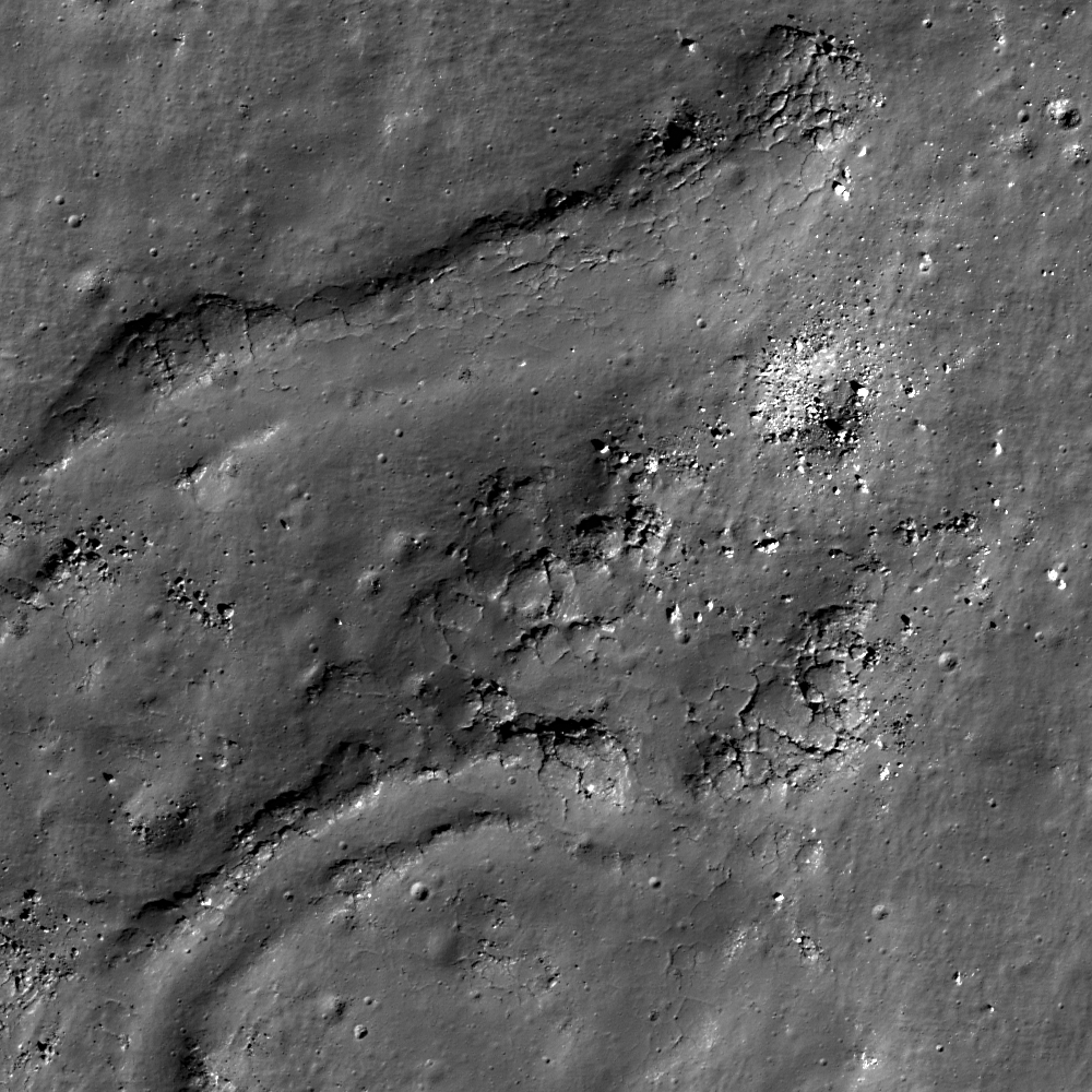
Channelized impact melt at Egede A

Impact melt, from nearby Egede A crater, formed channels as it flowed one kilometer down slope. Cracks in the melt probably formed as a result of cooling and inflation. Half-kilometer-wide field of view from LROC Narrow Angle Camera (NAC) frame M175204950LE, LRO orbit 10954, November 6, 2011; resolution 0.43 meters, in the original, an an incidence angle 63.49° from 29.54 kilometers [NASA/GSFC/Arizona State University].
Dew Enns
LROC News System

Impact melt creates spectacular morphologies on the Moon. Sometimes melt pools into large ponds, sometimes melt cascades down crater terraces, and sometimes melt forms channelized flows. The Egede A impact melt flows (as well as numerous other flows) are channelized with levees at their margins. Are there any analogues for channelized impact melt flows on Earth?

Yes! Levees occur naturally in terrestrial lava flows and develop as the edges of a lava flow cool and solidify. The lava flow can channelize with the levees help and make itself more thermally efficient. The levees allow the flow to travel farther from its source by slowing the cooling.

LROC Wide Angle Camera context image of the LROC Featured Image released November 6, 2012 (located in the white box). Egede A is a 12.3 km crater at 51.57° N, 10.51 E, northeast of the Vallis Alpes. Monochrome (604 nm) mosaic stitched from subsequent observation opportunities in orbits 3132 and 3134, March 2, 2010; from LROC WAC observations M122130239C and M122143802C. Resolution average 59.9 meters per pixel from 42 kilometers[NASA/GSFC/Arizona State University]. [NASA/GSFC/Arizona State University].
The morphological similarity between lava flows and impact melt implies they behave in a similar manner and have similar properties (temperature and viscosity).

Explore more of Egede A crater in the full LROC NAC, HERE.

Related Posts:
Winding Channel of Melt
Branched Impact Melts
Breached Levee
Shadows in Egede A 

In Mare Frigoris, on the entrance to Valles Alps opposite from Mare Imbrium, Egede A is easy to find through a modest telescope, Google Earth - Moon. True color still from a presentation prepared by the NASA Science Visualization Studio at Goddard Space Flight Center [NASA/GSFC/SVS]

Friday, August 31, 2012

"From the Earth to the Moon"

Still capture from "From the Earth to the Moon," produced by David Kring, CLSE, NLSI, LPSI.
I have often argued that the Moon is the best and most accessible place in the solar system for robotic and human assets to address fundamentally important scientific questions while simultaneously providing an opportunity to expand our technological capabilities. 

To remind ourselves of the opportunities on the Moon, the Center for Lunar Science and Exploration team has created a brief (3 minute) video with scenes so dramatic you may find yourself reaching out to pick up a rock and becoming restless for a chance to walk among lunar peaks.

The video and soundtrack "From the Earth to the Moon"
(http://www.lpi.usra.edu/nlsi/moonVideo/)

*       Provides an inspirational view of the lunar surface, which humans have not visited since 1972, despite being the best and most accessible place in the solar system to explore the fundamental principles of our origins;
*       Highlights vast portions of the lunar surface that have yet to be explored; and
*       Demonstrates how new images are revealing dramatic details of future landing sites suitable for both robotic and human missions.

I encourage you to download the HD version of the video (from the bottom of that website - cross-linked at the bottom of this post) to fully marvel at this tour of the lunar surface.  I also note that we have intentionally produced a few scenes with a patchwork of images of different resolutions to illustrate the additional detail that LRO has provided.

David A. Kring, Ph.D.
Center for Lunar Science & Exploration

Options for download

Downloads can be streamed by clicking on the options below.  For best viewing, however, you may want to right click, save the link to your own computer, and then play the file from your computer
Quicktime (HD 1080p)
Windows Media
(HD 720p)
iPhone 3gs/iPod video

iPhone 4/iPad

Thursday, July 19, 2012

Basin-forming impacts 'rounding' the lunar sphere

The consensus time-line places the 'basin-forming impact' by the progenitor of Mare Orientale as the end of the Lower Imbrium Age (3.85 - 3.75 billion years ago). A new study posits the global effect of such an impact on the shape of the Moon [NASA/GSFC/SVS].
The lunar surface is marred by impact craters, remnants of the collisions that have occurred over the past 4.5 billion years. The Orientale basin, the Moon's most recently formed sizable crater, stands out from the rest.

The crater, which lies along the southwestern boundary between the near and far sides of the moon, appears as a dark spot ringed by concentric circles of ejecta that reach more than 900 km from the impact location. Though other craters have similar rings, the lunar surface surrounding the Orientale basin is unusually rough with reduced concavity.

The anomalous features were identified by Kreslavsky and Head after they produced a map of the lunar surface topographic roughness using observations from the Lunar Orbiter Laser Altimeter aboard the Lunar Reconnaissance Orbiter.

The fact that other craters—even those of similar size and age—lack similar features suggests to the authors that mechanisms such as weathering or gravitational settling cannot explain the anomaly. Instead, the authors suggest that the Orientale basin, which formed about 3.8 billion years ago, stands out simply because it is the youngest large crater.

They propose that whenever a large body slams into the Moon, seismic waves produced during the impact travel through the solid lunar material, inducing seismic shaking that causes landslides and surface settling. They estimate that the impactor would need to be at least 100 km (62 mi) across to cause sizable seismic shaking.

Unfortunately, the authors may need to wait more than a little while to conclusively test their hypothesis—until the Moon is next rocked by a massive asteroid, an event not expected to occur in the foreseeable future.

M. A. Kreslavsky, J. W. Head, 'New observational evidence of global seismic effects of basin-forming impacts on the Moon from Lunar Reconnaissance Orbiter Lunar Orbiter Laser Altimeter data', Journal of Geophysical Research-Planets,doi:10.1029/2011JE003975, 2012

Sunday, September 19, 2010

LOLA data improves the crater count

Updated September 20, 2010 0051 UT

Another Gap. Following up on a global crater count and mean elevation study of LRO laser altimetry (LOLA), spotlighted by NASA, Sept. 16, another conspicuous, surprisingly oblong gap in the distribution of >20 km craters appears in and around Mare Orientale [NASA/GSFC/LOLA/Brown/SVS].

A study of 5,185 lunar craters of similar size, their global distribution and how their interior elevations deviate from the Moon's global average appears to confirm work by Wilhelms, El Baz and others, published a half-century ago.

Amazingly, those earlier investigators, who improved existing maps of the near side and mapped what was still being learned about the wildly different far side, did not have the benefit of laser altimetry streaming down from the LOLA instrument on board the Lunar Reconnaissance Orbiter (LRO).

More amazing, the Moon's mean elevation, its average radius of 1737.5 kilometers, was far from accurately understood. The LAT package on board JAXA's Kaguya (SELENE-1) isolated the Moon's elusive center further, from within 2 km to within about 200 meters.

In comparison, the Brown University study authored James W. Head is rather like modern lunar instrumentation rated against Apollo guidance computers.

Originally, grid by grid, with slide rule geometry and calculus, plugging time and illumination angles into formula, crater counts of extraordinary accuracy were weaved together by patient investigators. Their published conclusions continue to be confirmed in the mining of laser data from LRO. But questions raised by them stubbornly remain unanswered by 21st century remote sensing. The Ground Truth is still irreplaceable


James W. Head of Brown University has performed a global census 5,185 lunar craters >20 km. in diameter. The study, published in Science, includes a global color-coded tally of the crater's interior elevations, showing deviation from the Moon's global mean "sea level" of 1737.5 km. Not surprisingly, a thinner population of such craters are found in and around familiar near side basins, reconfirming conclusions from long ago that the huge plains represent younger surfaces. (Of craters included in the Brown University census, green = mean global elevation; bluer = below, yellower = above.) [NASA/GSFC/LOLA/Brown/SVS]

So what are these data telling us, confirming theories and restating questions asked by the Light and Shadow slide rule guys of the Apollo era?

Broadly speaking, the Moon holds a reliable record of the history of the Solar System, a record largely lost to water, dynamic weather and plate tectonics on Earth. The Moon's obvious proximity shows this history is also the history of Earth, particularly the history of conditions in that part of the Solar System simultaneously occupied by both bodies.

And the Moon's surface tells a story writ large in bombardment, beginning a very long time ago with the large impactors, like the 4 billion year-old event that formed the 2,100 km-wide South Pole-Aitken basin or the 1290 km-wide Imbrium event that probably happened less than a few hundred million years later. All through the course of the past 4,500 million years, smaller but also respectable kinds of interlopers that punched out the craters in the Head census have continued to "encounter" the Moon with decreasing frequency.

If our dating of features on the Moon's surface is close to being correct, the fall-off in this more common kind of bombardment must have been fairly rapid. Otherwise, the 3.9 billion year-old near side basins, "only" a half-billion years or so after the Moon's magma ocean solidified, would be more punctuated with craters.

The evidence, particularly after studies of the Moon's far side literally entered the picture in 1959, hints that between the formation of SPA and the more familiar near side basins, a gradual decline in these "mid-sized" impacts may have reversed for a 150 to 200 million years before resuming its decline. This is the strongest evidence we have for what's become known as the Grand Bombardment, possibly a juggling of material perturbed as the outer planets, for some unknown reason, waltzed for several million years until stabilizing into their present orbits.


The presentation of the LOLA data study, prepared by the Science Visualization Studio (SVS) at NASA Goddard, was atypical in not including the classic near and far side panels; the two hemispheres shown side by side, centered on the 0° and 180° meridians. The SVS illustrations do include the separate panel above, centered on 90° and 900 frames from their animation. And the animation presents the 5,185 color-coded craters in a way that fancifully builds up gong from east to west as Moon rotates once around. This method does not allow for a view centered over any areas of interest other than the two equatorial slides. If you want to see the census results over Mare Orientale, for example, as at the head of this post, the area of interest falls behind before becoming fully populated [NASA/GSFC/LOLA/Brown/SVS].

Nevertheless, as the the Moon rotates, another second gap appears in the crater count, this time arguably in the the lunar highlands but hardly typical in composition, an oblong gap 2000 kilometers north to south and 1200 km wide centered on Mare Orientale.

Orientale was a late comer, slightly smaller and perhaps more energetic than the great basin-forming impacts of a billion years earlier. If dating methods are reliable, then the fall-off in >20 km-wide impact events had fallen to a trickle by the time of Orientale's formation, 3.1 billion years ago. Some studies hint the Orientale event was energetic enough to have caused an upwelling of molten material in the near side basins, the many ponds of mare material within South Pole-Aitken and elsewhere.

Additional Reading:
The Moon through LRO's eyes
Kelly Beatty
Sky & Telescope