Showing posts with label Harrison Schmitt. Show all posts

Saturday, February 8, 2014

Special Session, LPSC 2014 (March 17)

 45th Lunar and Planetary Science Conference
New Perspectives of the Moon -
Enabling Future Lunar Missions
The Woodlands, Texas
Monday Morning, March 17, 2014

Prasun Mahanti and Charles Shearer, Chairs

Recent and ongoing missions coupled with new data analyses have dramatically changed our view of the Moon over the last decade. Findings from these missions provide both a fundamental scientific framework to base future missions and essential observations to reduce risk to these missions. Presenters will provide new scientific synthesis of data produced from recent and current lunar missions and data analyses and examine innovative scientific mission strategies enabled by these new insights to address important lunar science and exploration questions.

At Noon on Monday, astronaut-geologist Harrison H. Schmitt will update this special session on "a number of new insights into the geology of Taurus Littrow and surrounding regions."
8:30 a.m. Zuber, Smith, Goossens, Asmar and Konopliv, et al. - A High-Resolution View of the Orientale Basin and Surroundings from the Gravity Recovery and Interior Laboratory (GRAIL), #2061

During the final weeks (the “endgame”) of the Gravity Recovery and Interior Laboratory (GRAIL) mission the orbital altitude of the dual spacecraft was lowered to an average of 11 km above the surface of the Moon. The endgame mapping strategy was designed to provide the highest-resolution coverage over the Orientale basin in order to provide a gravity map of a multi-ring impact basin at unprecedented resolution. (High-resolution data over other areas of the planet were acquired as well.)  We summarize methodology and present results of local analysis to produce a gravitational model with 3-5-km spatial resolution, appropriate for investigating the structure and evolution of Orientale and its surroundings.

8:45 a.m. Warren and Dauphas - Revised Estimation of the Bulk Composition of the Moon in Light of GRAIL Results, and Why Heat Flow Should be a Top Priority for Future Lunar Missions, #2298

The elemental composition of the Moon shows aspects of similarity but also some important differences relative to Earth. The differences are key constraints for modeling the origin of the Moon and planetary origins in general. Most obviously, and regardless of the important FeO issue that is a major focus of this work, the Moon’s total iron content is lower by a factor of 3-4 compared to Earth’s total iron of ~34 wt%.

9:00 a.m. Jolliff and Petro - Recent Mission Observations Provide Scientific Context and Enabling Support for Future Exploration of the Moon’s South Pole-Aitken Basin, #2357

We take an integrated look at results from recent missions, current knowledge gaps, and implications for future in situ or sample-return exploration.

LPSC 2014, #1398, Figure 1. Central South Pole-Aitken basin, LROC WAC base mosaic overlain by GLD100 WAC-derived DTM (scale in meters) showing current NAC geometric stereo image coverage.
The Moon’s South Pole-Aitken (SPA) Basin is a scientifically rich destination for future exploration by landed and sample-return missions.  The current Planetary Science Decadal Survey recognized this scientific potential in terms of the SPA basin’s importance for recording the chronology of major events in the early Solar System as well as for understanding lunar history, structure, and giant impact processes. Current and recent orbital mission results including LRO, GRAIL, Chandrayaan-1, and Kaguya are paving the way for an improved understanding of SPA basin geology and history, and indeed, posing new questions for future exploration.

9:15 a.m. Hurwitz and Kring - Destinations for Sampling Impact Melt Produced by the South Pole — Aitken Basin Impact Event, #1398

LPSC 2014 #1398, Figure 1: FeO (red-yellow tones) and Th (green-blue tones) anomalies from LP data in SPA, shown with images from the LRO Wide Angle Camera (WAC). Features of interest are labeled. SPA melt may also be found in material ejected from the basin, but the anomalies identified above indicate the highest concentration of this melted material.
The intensity of impact activity during the earliest history of the Solar System is poorly constrained due to the lack of samples collected from ancient planetary terrains. The South Pole – Aitken (SPA) basin is the oldest basin identified on the Moon based on stratigraphic superposition and, thus, represents a key target for characterizing this earliest impact record. To determine the absolute age of SPA, rocks that formed as a result of the impact, such as impact melt, must be identified, collected, and analyzed. In this paper, we use high-resolution images obtained by the Lunar Reconnaissance Orbiter Narrow Angle Camera (LROC NAC) to explore locations that potentially contain SPA impact melt. These observations are integrated with spectral analyses of surface compositions and models of melt sheet differentiation to identify destinations where SPA impact melt samples can be collected.

9:30 a.m. Lawrence, Stopar, Speyerer, Robinson and Jolliff - Characterizing Locations for Future Lunar Exploration Using Recent Mission Results, #2785

LPSC 2014, #2785 Figure 1. Example path planning algorithm output for Ina on a LROC Narrow Angle Camera image.
We present results from a project to characterize accessibility and science potential of high-priority locations for future lunar precursor missions.

9:45 a.m. Mahanti, Robinson and Stelling - How Deep and Steep are Small Lunar Craters? — New Insights from LROC NAC DEMs, #1584

Recent lunar missions (e.g. Lunar Reconnaissance Orbiter (LRO), Kaguya), carrying high resolution cameras (e.g. Lunar Reconnaissance Orbiter Camera (LROC) Narrow Angle Camera (NAC), Selene Terrain Camera) have acquired images that will lead to a deeper understanding of impact crater formation and degradation. Historical studies of lunar crater morphology exists for craters in the 10 km diameter range, but is somewhat lacking for craters in the 1 km D range, and rare for craters D below 200 m.

10:00 a.m. Robinson, Boyd, Denevi, Lawrence and Moser, et al. - New Crater on the Moon and a Field of Secondaries, #2164

LPSC 2014 #2164 Figure 1. LROC Narrow Angle Camera (NAC) before and after images of the same small patch of Mare Imbrium reveal the Marshall 17 March Impact Event, the first time an impact on the Moon observed on Earth in real time has been definitively identified from lunar orbit. The newly-formed crater is 18 meters in diameter. From "New Imbrium crater from impact observed on Earth" (December 17, 2013) [NASA/GSFC/Arizona State University].
Amateur and professional observatories monitor the Moon for flashes, interpreted to represent impact events. The NASA Lunar Impact Monitoring Program includes a dedicated telescope facility at Marshall Space Flight Center. The Marshall group recorded over 300 flashes (meteoroid impacts); their brightest recorded flash occurred on 17 March 2013 (20.599±0.172°N, 336.078±0.304°E). Subsequently, a series of Lunar Reconnaissance Orbiter Camera (LROC) Narrow Angle Camera (NAC) images were acquired over the period of June through November 2013 to investigate the nature of this flash.

LPSC 2014 #2164 Figure 2. Temporal ratio (before M183689789L / after M1129645568L) orange outline delimits proximal high reflectance ejecta, red line is the boundary of low reflectance ejecta, blue outline shows boundary of high reflectance outer continuous ejecta, scale bar is 1000 meters.
10:15 a.m. Lucey, Neumann, Paige, Riner and Mazarico, et al. - Evidence for Water Ice and Temperature Dependent Space Weathering at the Lunar Poles from LOLA and Diviner, #2325

LOLA measurements of zero phase reflectance of the Moon have revealed that polar regions in permanent shadow are significantly brighter at 1064 nm than equivalent surfaces that experience some illumination during the year Zuber et al. Several hypotheses for this brightening have been outlined, including water frost and a polar effect on space weathering.  Inclusion of Diviner temperature measurements to LOLA reflectance observations adds a physical chemical dimension to aid interpretation because of the exponential temperature dependence of surface frost lifetime against sublimation. In this abstract we present the results of LOLA measurements of surface reflectance in the polar regions, and assess the validity of the various hypotheses to explain the observations with special attention to temperature.

LPSC 2014 #2325, Figure 2. The distribution of normal albedos for areas in permanent shadow (PSR) and areas sometimes illuminated (Non-PSR) in the north pole (70-90°N). The two populations are significantly offset, though considerable overlap persists.
10:30 a.m. Retherford, Greathouse, Gladstone, Hendrix and Mandt, et al. - New Perspectives on the Lunar Far-UV Albedo: Implications of LRO Lyman Alpha Mapping Project (LAMP) Results for Future Exploration, #2372

LAMP FUV albedo maps are used to investigate the intriguing albedo differences that occur within PSRs. LAMP measurements indicate ~1-2% surface water frost abundances in a few PSRs based on spectral color comparisons, and we find that many PSRs may have porosities of ~0.7 based on relatively low albedos at Lyman-α [1]. The FUV albedo maps reveal lower albedo regions within craters. The lower albedo regions are roughly correlated with the coldest PSR regions, and Hayne et al., this meeting, will pre-sent correlative analyses with Diviner maps. Mandt et al., this meeting, will present updated analyses of the PSR water frost abundances including a search for changes on monthly timescales.

New dayside FUV albedo maps will also be pre-sented. Comparisons between the nightside and day-side photometry techniques help validate the use of Lyman-α and starlight as illumination sources. Analy-sis of dayside spectra for selected regions complement the dayside maps, and are used to investigate space weathering and hydrated surface signatures [5]. Hen-drix et al., this meeting, report that the Compton-Belkovich region presents a relatively red spectral slope in the LAMP dataset, and discuss the potential for surface hydration in this region. A lab study of the FUV reflectance properties of Apollo samples, lunar simulants, and water ice is underway to further charac-terize the UV reflectance techniques. The far-UV spec-tral inversion property of the lunar albedo discovered by the Apollo 17 UVS is confirmed with the LAMP dataset, and Seifert et al., this meeting, investigate fur-ther the contrast of UV-bright mare versus UV-dark highlands region features as a function of wavelength.

LPSC 2014 #1943 Figure 1. Overlay of Diviner annual maximum temperature (colors: 40-350 K) and Ly-α albedo from LAMP (grayscale) for the south polar region of the Moon. The outer edge of the Diviner map lies at 82.5°S.
10:45 a.m. Hayne, Retherford, Sefton-Nash and Paige - Temperature and Ultraviolet Albedo Correlations in the Lunar Polar Regions: Implications for Water Frost, #1943

LPSC 2014 #1942 Figure 3. Surface material with high UV water band depth from LAMP and Diviner Tmax < 130° K is indicated by shades of red in this south polar map. The background grayscale image is Diviner Tmax, a subset of Fig. 1.
11:00 a.m. Zhao, Huang, Xiao, Qiao and Xiao, et al. - Geology of CE-3 Landing Site and Path Planning for Yutu Rover, #1864

Nearly 40 years after the completion of Apollo program and Luna missions, the third Chi-nese lunar mission, Chang’e 3 (CE-3), was launched on December 2 2013, and it safely landed on the surface of the Moon on December 14 2013. The rover “Yutu” separated from the lander successfully about 8 hours later. The landing site of CE-3 is 340.49 °E, 44.12 °N, located in the northern part of Mare Imbrium and about 140 km east to Sinus Iridum. The landing area has a variety of geologic features, such as impact craters, wrinkle ridges and basaltic lava flows with different ages, making it an arresting place to study.

11:15 a.m. Garry W. B. - The Mare Imbrium Flow Field: Regional Geologic Context of the Chang’e 3 Landing Site, #2169

LPSC 2014 #2169 Figure 3. Topographic profiles of two different Phase III lava flows. Low-sun angle images show channels that are a few meters deep in the majority of the Phase III flows indicating preferred paths in many of these lobes.
The Mare Imbrium lava flows are unique to the lunar surface in that they have well-defined flow margins, levees, and channels that are traceable from the source region to the flow front. These flows were initially mapped with Apollo data [4,5], but the data sets did not provide complete coverage of the flow field at a consistent resolution. The overall goal of this study is to reevaluate the flow field with current data sets, create an updated morphologic map of the Mare Imbrium lava flows, and provide a qualitative and quantitative description of the emplacement of the flow field.

11:30 a.m. Hiesinger, Ivanov, Pasckert, Bauch and van der Bogert - Geology of the Lunar Glob Landing Sites in Boguslawsky Crater, #2370

LPSC 2014 #2370 Figure 2. New geologic map of Boguslawsky crater (72.9°S, 43.257°E). Landing ellipses shown in white.
On Nov. 17, 2011, the Space Council of the Russian Academy of Sciences, formally announced that the Luna-Glob and Luna-Resurs missions will be split into separate landing and orbiting missions. Although the main objective of the Luna-Glob lander is to test landing techniques, it will also carry a small scientific payload. The floor of crater Boguslawsky (~95 km in diameter, centered at 72.9°S, 43.26°E) was selected as primary landing site for the Luna-Glob mission. Two landing ellipses, 30x15 km each, were chosen on the  floor of the crater: Ellipse West is at 72.9°S, 41.3°E, Ellipse East is at 73.3S, 43.9E.

11:45 a.m. BREAK

12:00 p.m. Schmitt H. H. - Apollo 17: New Insights from the Synthesis and Integration of Field Notes, Photo-Documentation, and Analytical Data, #2732

A number of new insights into the geology of the valley of Taurus-Littrow and surrounding regions of the Moon have resulted from recent synthesis and integration of transmitted field notes, field recollections, and photodocumentation with over forty years of data from sample analysis and geophysical measurements.

Jack Schmitt's trench and the orange regolith he uncovered at Shorty crater. The minutes spent at this location left a deep mark on planetary science, visible from the Lunar Reconnaissance Orbiter and discussed by LROC principal investigator Mark Robinson in "Just another crater?" December 13, 2011; Apollo 17 Lunar Surface Journal. AS17-137-20900 [NASA].
For further information about the 45th Lunar and Planetary Science Conference visit:
http://www.hou.usra.edu/meetings/lpsc2014/

Sunday, December 15, 2013

Apollo 17, Station 6

Station 6, Apollo 17
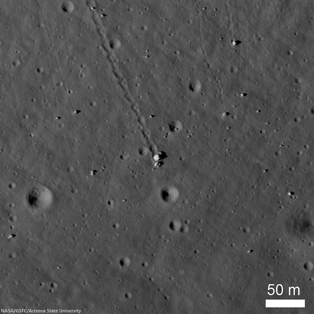
Station 6 allowed Apollo 17 astronauts Eugene Cernan and Jack Schmitt to explore a collection of boulders and regolith that represent rocks from the mighty North Massif. Five large boulder fragments lie at the base of a long boulder trail, all from a single boulder that rolled down the hill and broke apart. LROC Narrow Angle Camera (NAC) observation M134991988R, spacecraft orbit 5027, July 28, 2010; angle of incidence 64.66° at 0.5 meters resolution from 43.83 km over 19.19°N, 30.8°E [NASA/GSFC/Arizona State University].
Jeffrey Plescia
LROC News System

The North Massif lies along the northern side of the Taurus-Littrow Valley, the landing site of Apollo 17. Station 6 was visited during the third and final surface EVA of the expedition and of the Apollo program, December 13, 1972, and was intended as a location to collect ancient highland material from the North Massif as well as a dark mantle that locally covers the region.

The sampling station is about 100 meters above the general valley floor elevation of 2560 meters below global mean average. The North Massif rises some 1400 meters above Station 6 and likely formed in a few seconds as the result of the massive impact that created the Serenitatis Basin.

One of the key science goals at Station 6 was to collect impact melt caused by that event. When rock is melted its radiometric clock is reset to time zero, so a sample of impact melt can be age-dated to determine when the basin formed.

Station 6, Apollo 17
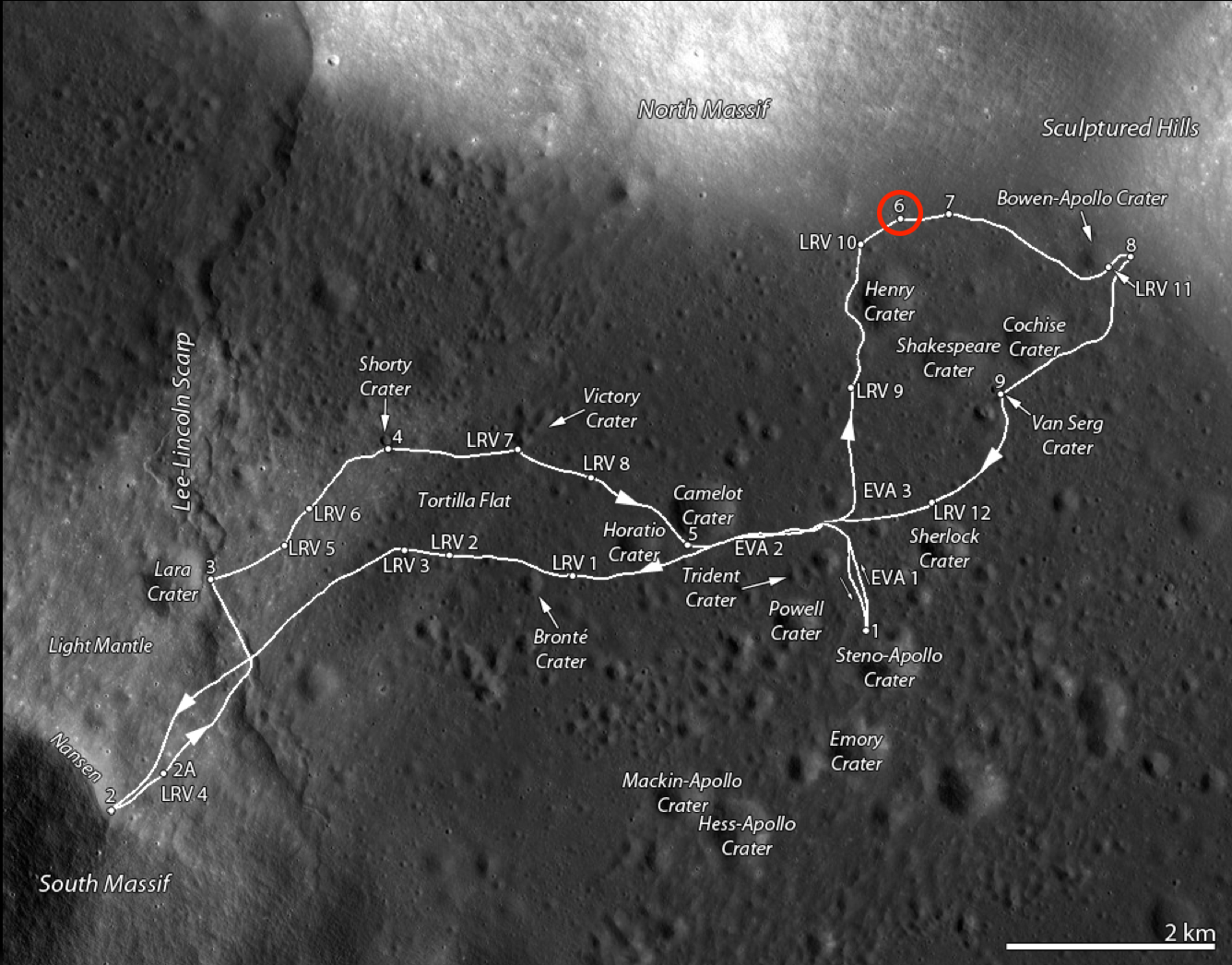
Traverse map of the Apollo 17 site. Station 6 is along the base of the North Massif on the north side of the valley and is circled in red [NASA/GSFC/Arizona State University].
At Station 6, five large blocks are clustered together on a surface that slopes toward the valley floor at about 16°. They lie at the end of a 980 m long boulder trail that formed as a single large boulder rolled down the hill. The trail is about 10-12 m wide with a scalloped edge and periodic small transverse ridges. This irregular pattern is the result of the irregular shape of the boulder. The original boulder was probably about 18 x 10 x 6 m. The largest fragment (Block #2) is about 10 m across.

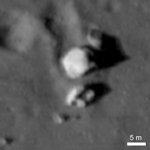
It appears that the rolling ceased when the boulder broke apart and came to the rest in its present location. As the boulder rolled down the hill slope, it pushed up material along the edge of the track forming a berm. A small berm is also visible in front of the largest fragment. An expanded view of the boulders from an LROC image is shown below. Subtle brightness differences are apparent in the largest boulder in the center, and correspond to different rock types (the boulder is a breccia).

Station 6, Apollo 17
The five major blocks at Station 6, and an additional one farther down slope, are clearly visible in LROC NAC M134991788RE, as is the boulder trail above the blocks. Afternoon illumination, sun from the west [NASA/GSFC/Arizona State University].
Pictures taken during the Apollo 17 EVA at Station 6 illustrate the relative size of the boulders; below Jack Schmitt is seen after after sampling the boulders.

Station 6, Apollo 17
Jack Schmitt picking up the gnomon after collecting samples. This view is to the southwest, and the Apollo 17 lunar module stands sentinel in the upper right deep background (AS17-140-21496) [Eugene Cernan/NASA/JSC].
Jack Schmitt put the Apollo 17 lunar module "Challenger" in some perspective, capturing this monochrome shot, through a 500 mm lens, and from over 3 km) from Station 6. From another panorama of EVA images, AS17-139-21203-5 [Harrison Schmitt/NASA/JSC].
A number of samples were collected at Station 6. The illustration below shows the boulder group and a map made during the mission. The map indicates the location of the rock and soil samples as well as the location of the panoramic images.

Station 6, Apollo 17
LROC image of the boulder complex (top); map of the boulder segments and the sample locations (below). North and South Panoramas designate locations where the hand-held panoramic image sequences were captured. The numbers refer to specific Apollo samples [NASA/GSFC/Arizona State University].
Samples from the station include a single drive tube, ten rock samples (3 from the surface, four from block 1, one each from blocks 2, 4, and 5), several sediment samples (3 from between major blocks, one down slope from the blocks, one from the boulder track, and another from on top of block 1), and one rake sample from the ejecta blanket of a small crater to the northwest of the blocks.

Station 6, Apollo 17
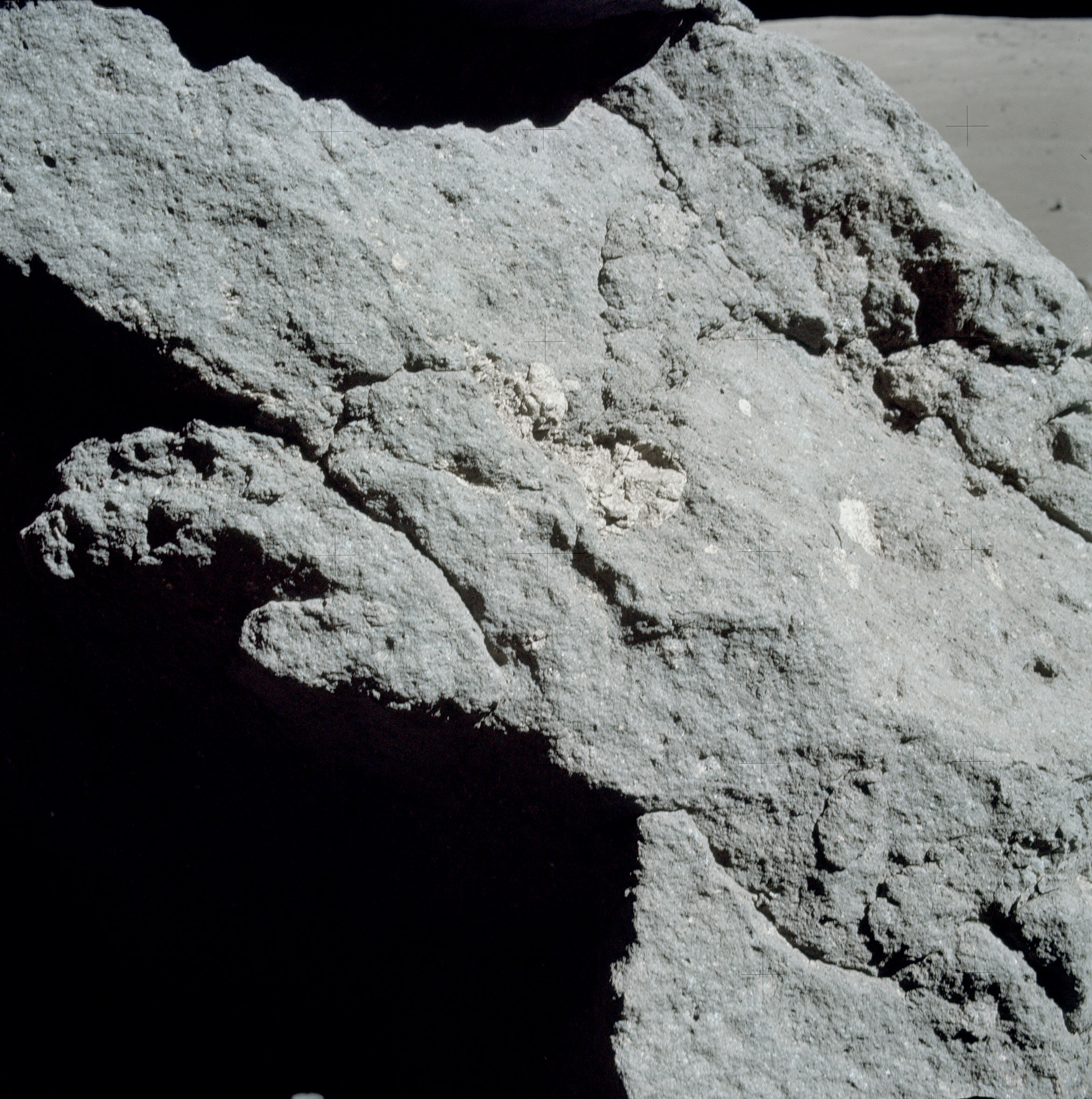
Light-colored inclusions in the matrix of one of the boulders (Block 1) (AS17-140-21442) [NASA/JSC].
The boulders consist of clast-bearing impact melts. Despite the color differences, foliation and frequency of vesicles, the boulders consist of a chemically uniform matrix with clasts ranging in size up to about 1 meter in diameter. The clasts consists of rocks across the anorthosite-norite-troctolite suite or their impact-modified derivatives. Simonds (1975) suggested that the matrix is a clast-bearing rock formed by the mechanical mixture of cold, generally little-shocked clasts and superheated impact melt that rapidly quenched to form very-fine subophitic to ophitic crystalline groundmass. These samples have ages of around 3.98 Ga and are interpreted to represent the age of basin-forming event that produced the material, probably the Serenitatis Basin (as discussed in Ryder et al., 1997). However, more recent work suggests that the rocks collected at Station 6 may actually be ejecta from the Imbrium Basin forming event.

Explore the Taurus-Littrow Valley yourself, HERE.

Previous LROC Featured Images RE: Apollo 17:
Oblique view of Taurus Littrow, from the West (December 19, 2012)
Approach To Taurus Littrow Valley (December 11, 2012)
Taurus Littrow Oblique (September 29, 2012)
Question Answered! (July 17, 2012)
Just Another Crater? (December 13, 2011)
Skimming the Moon (September 6, 2011)
Exploring the Apollo 17 Site (October 28, 2009)

Thursday, July 25, 2013

Snapshots from the Moon and Cislunar Space

Apollo 17 commander Eugene Cernan (UR, LR), CM pilot Ron Evans (UL, LR) and LM pilot and geologist Harrison "Jack" Schmitt (LL) relaxing in the Apollo 17 Command Module America after Cernan and Schmitt returned from three days of exploring the magnificent Taurus Littrow valley, the last manned expedition to the lunar surface 40 years ago, December 1972 [NASA/ Arizona State University].
Mark Robinson
Principal Investigator
Lunar Reconnaissance Orbiter Camera
Arizona State University

This year, we commemorate the forty-fourth anniversary of the first human lunar landing. By now, the whole world is very familiar with the high-quality Hasselblad snapshots taken by the Apollo astronauts during their voyages. However, 35-mm cameras were also carried on some of the Apollo missions for both surface and orbital imaging. Most of the surface 35-mm images are extreme closeups of the lunar regolith from the Apollo Lunar Surface Closeup Camera (ALSCC; Apollo 11, 12, 14); sometimes called the Gold Camera after its Principal Investigator Thomas Gold.

The Nikon camera used on board the Apollo Command Module was equipped with a 55-mm lens and was loaded with either black-and-white or color film. During Apollo missions 16 and 17, black-and-white film was used for dim-light photography of astronomical phenomena and lunar surface targets illuminated by Earthshine. During Apollo 17, color film was used for documenting various activities in the Command Module.

The 35-mm frames are now scanned as part of a joint project between Arizona State University and the NASA Johnson Space Center to scan all of the original Apollo flight films.

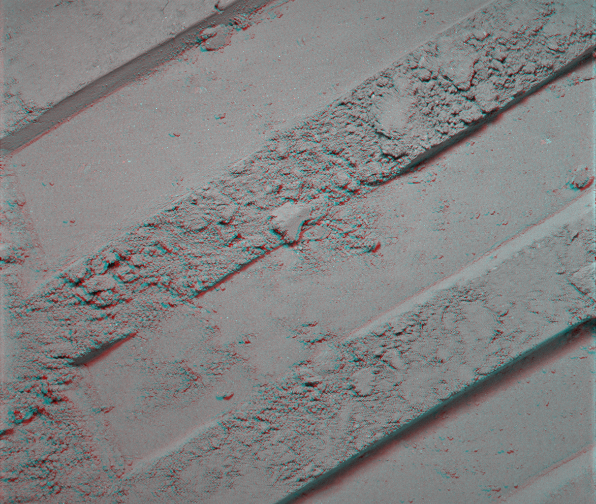
Boot print anaglyph - Stereo anaglyph (get out your red-blue stereo glasses!) AS14-77-10369a,b from the ALSCC showing extreme detail of an astronaut bootprint in the fine-grained lunar regolith. The original field of view is about 3 inches on a side [NASA/Arizona State University].
The Apollo 17 crew seems to have had the most fun with the 35-mm format! Gene Cernan, Ron Evans and Jack Schmitt snapped quite a few spectacular black-and-white images showing the view out of the window of their Command Module, the America. Some of these images are a bit grainy, resulting in a very different feeling than the crisp Hasselblad photographs. They also took numerous color candid shots inside the Command Module. It is rare to see such carefree moments during the Apollo missions, but you can feel the relief and happiness after the astronauts so successfully fulfilled their surface mission!

Reiner Gamma illuminated solely by earthshine (35-mm Apollo 17) - Reiner Gamma, one of the enigmatic lunar swirls; their origin is related to localized magnetic fields within the crust AS17-158-23894 [NASA/Arizona State University].
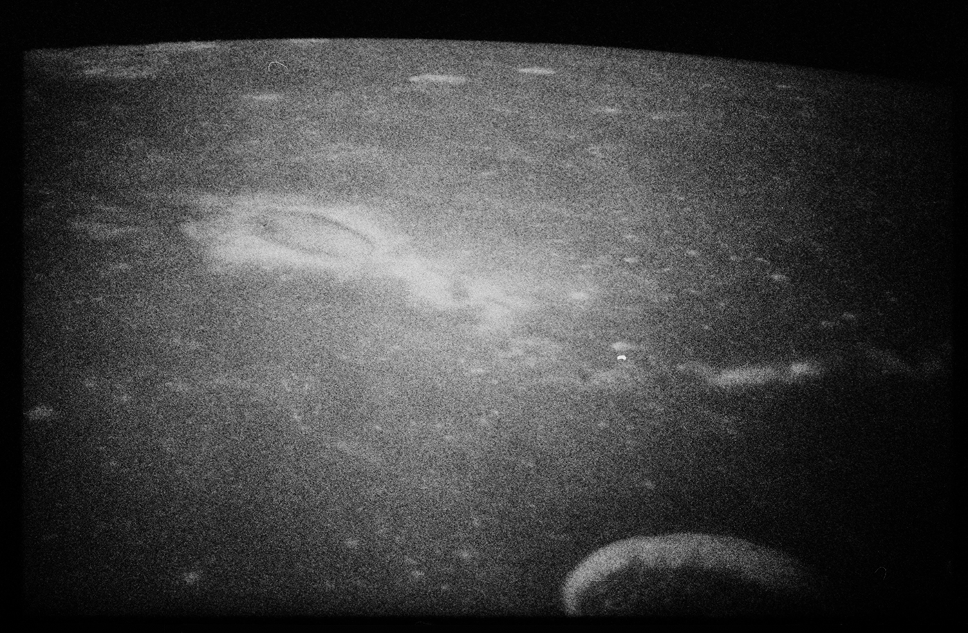
Many of the window shots present an oblique view across lesser known regions of the Moon. The terminator (boundary between night and day) scenes are always captivating. Look closely at the scene below; near the center is a shallow-sloped scallop-shaped rise. Just below and to the right are two other smaller rises - perhaps these are low shield volcanoes? You can dig deeper by visiting the LROC QuickMap browser and see if the NAC images can elucidate what is seen here (Natasha crater is at 19.973°N, 328.843°E).

Mare Imbrium meets Mare Procellarum (Apollo 17 35-mm frame) a complex region composed of nearly buried peaks that are part of the Imbrium rim, impact craters, and volcanic forms. Annotated AS17-160-23992 [NASA/Arizona State University].
Relive the incredible adventure that was Apollo, browse the Apollo 35-mm archive and the rest of the Apollo scans (Metric, Pans; Hasselblads to follow next year). While browsing, map out your own next mission to the Moon! The hard part is figuring out where to visit next. Enjoy!

Related Posts:
Project Mercury Photography Now Online
Project Gemini Comes to Life
Reiner Gamma Constellation Region of Interest
Mare Ingenii Swirls

Wednesday, December 19, 2012

Oblique view of Taurus Littrow, from the West

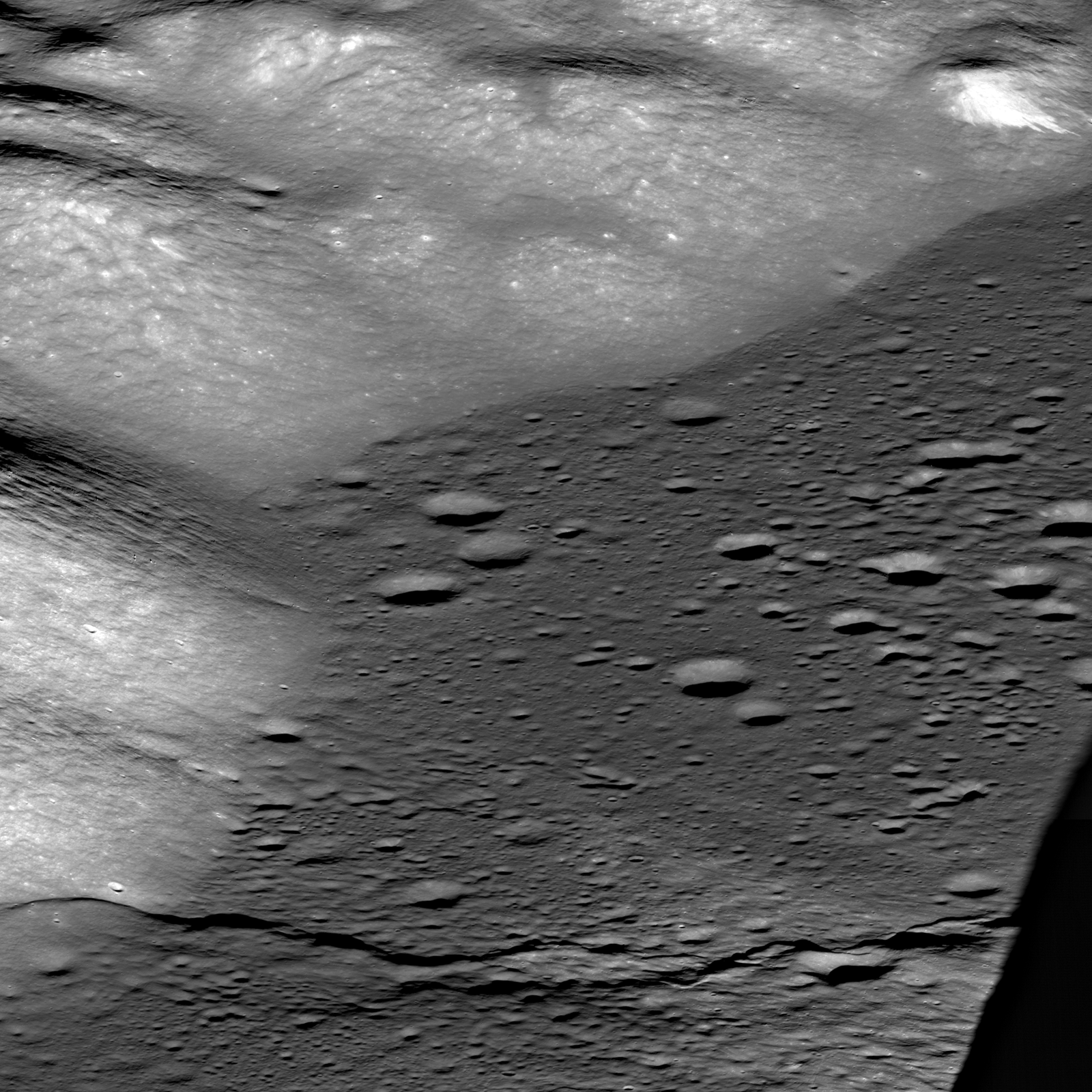
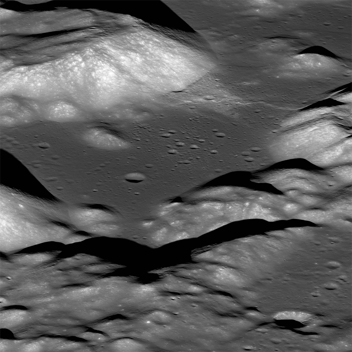
The magnificent Taurus Littrow valley photographed obliquely, from a point 330 km west by northwest, 131.12 km over central Mare Serenitatis, by the LROC Narrow Angle Camera (NAC). The Apollo 17 crew briefly explored this valley 40 years ago this month. LROC NAC observation M1096343661LR, a field of view roughly 10 km across the center; LRO orbit 13936, July 7, 2012 [NASA/GSFC/Arizona State University].
Mark Robinson
Principal Investigator
Lunar Reconnaissance Orbiter Camera
Arizona State University


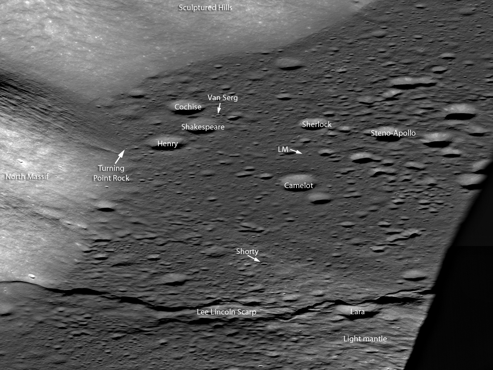
In the lower right, South Massif casts a long evening shadow across the mare basalt flooded Taurus Littrow valley. Note the sharp boundary of the flat mare against the slopes of the Sculptured Hills in the background, similar to a lake shoreline, revealing the very fluid nature of the lava when it filled the valley. Your eye is drawn to the sharp line snaking across the bottom of the image. Note how this ridge traverses across the valley floor and up onto the lower slopes of North Massif (lower left). Astonishingly this feature is a large, young fault: imagine the ground in the foreground being pushed to the east and the crust buckling, a whole section was pushed up and onto the back side of the fault (low angle thrust fault). This step in the valley floor was the result of large scale contractional forces pushing the crust together. The landform created by this type of thrust fault is called a lobate scarp, this one is named the Lee Lincoln scarp. The Lee Lincoln scarp has the distinction of being the first and only extraterrestrial fault to be explored by humans. Astronauts Harrison Schmitt and Gene Cernan actually drove the Lunar Roving Vehicle (LRV) up and over this ridge during their three day exploration of the valley.

Apollo 17 commander Gene Cernan works next to the LRV at Station 3, near Lara crater, (see labeled detail below). AS17-138-21168 [NASA/Harrison Schmitt].
Where the Lee Lincoln scarp stretches into the highlands of North Massif, it abruptly changes directions and extends along slope far beyond the Apollo 17 landing site (black arrows on full NAC image).  The Lee Lincoln scarp is one of a number of such tectonic landforms that were only found in the high resolution Apollo Panoramic Camera images that covered part of the lunar equatorial zone. In LROC NAC high resolution images, lobate scarps have been discovered across the Moon at all latitudes (Watters and coworkers, 2010). The pristine appearance of the lobate scarps and the fact that the features cut across young, small-diameter craters are evidence that the scarps formed recently, more recently than the young craters they deform. The globally distributed population of lobate scarps is an indication that contractional forces are acting on the lunar crust as a result of slow cooling and shrinking of the still hot interior of the Moon.

West to east Oblique labeled - Central portion LROC NAC oblique showing significant features visited by the Apollo 17 crew, LM is the Lunar Module. North is to the left, and south is to the right. The distance along Lee Lincoln scarp from the shadow to North Massif is 8 km, M1096343661LR [NASA/GSFC/Arizona State University].
It was forty years ago today that the Apollo 17 crew splashed down in the Pacific Ocean, ending our first period of human exploration of the Moon. The extensive measurements beamed back from LRO every day are setting the stage for the next era in robotic and human exploration of the Moon. Where would you go on the Moon to continue the work of the Apollo crews?

Trace the Lee Lincoln scarp, HERE, as it snakes its way northward, well away from the Taurus Littrow valley (VSC Van Serg Crater, SC Shorty Crater, LM Lunar Module).

Previous Apollo 17 Featured Images:
Approach To Taurus Littrow Valley (December 12, 2012)
Apollo 17 lands, ending the Apollo era, 40 years ago (December 11, 2012)
The last manned launch to the Moon (December 7, 2011)
Taurus Littrow Oblique (September 29, 2012)
Question Answered! (July 17, 2012)
Significant change in bombardment timing (January 6. 2012)
Just another crater? (December 13, 2011)
Skimming the Moon (September 6, 2011)

Exploring the Apollo 17 Site (October 28, 2009)

Friday, December 14, 2012

On the 40th Anniversary of the last Moon Walk


"To mark the 40th anniversary of the last human footsteps on the moon," Andrew Chaikin, author A Man on the Moon (Penguin, 2007), looks back "at Apollo 17's explorations, and I explain why I believe the moon is the solar system's "jewel in the crown," beckoning us to return.

YouTube, Published December 14, 2012

Wednesday, December 12, 2012

Approach to Taurus Littrow Valley

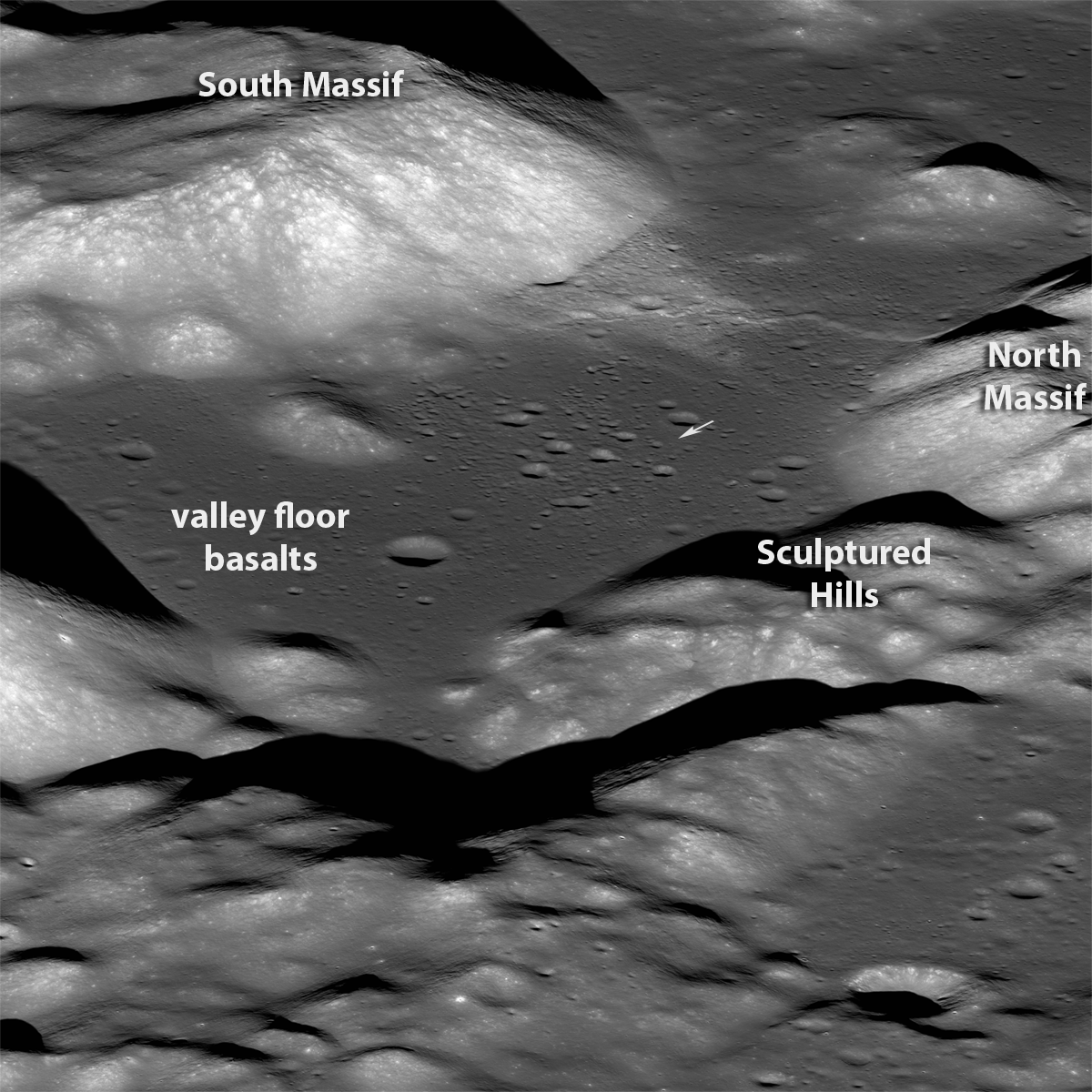
Taurus Littrow Valley from the east. View similar to what the Apollo 17 astronauts saw as they approached their landing in the magnificent Taurus Littrow Valley. (See "Taurus Littrow Oblique," September 29, 2012) LROC Narrow Angle Camera (NAC) east-to-west oblique image pair, about 18 km wide field of view at center, M192703697LR, LRO orbit 13427, May 26, 2012; spacecraft (and camera) slewed 56.09° west from nadir, native resolution 2.79 meters, from 131.29 km over 20.01°N, 38.78°E [NASA/GSFC/Arizona State University]. [NASA/GSFC/Arizona State University].
Mark Robinson
Principal Investigator
Lunar Reconnaissance Orbiter Camera (LROC)
Arizona State University


The Apollo 17 astronauts landed in the Taurus Littrow Valley forty years ago today. One of their key science goals was to collect impact melt from the Serenitatis basin rim so an age date for this important basin could be established. Before the samples were returned most lunar geologists believed this basin to be relatively old amongst all lunar basins. When the age dates came in from the Apollo 17 highland impact melt samples it appeared that the Serenitatis basin was younger than previously thought (3.86 billion years), nearly the same age as the mighty Imbrium basin (young in terms of lunar basins!). Jack Schmitt and Gene Cernan sampled rocks from South and North Massifs and the Sculptured Hills, all three thought to be formed as part of the Serenitatis basin impact event.


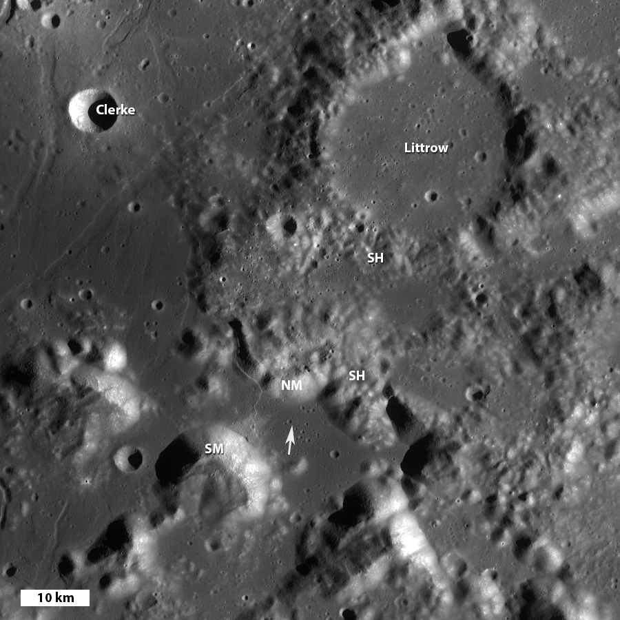
Taurus Littrow valley to Taurus crater, the upper left corner (NW) is the eastern edge of the mare flooded Serenitatis basin. LROC Wide Angle Camera (WAC) mosaic: SM = South Massiff, NM = North Massif, SH = Sculptured Hills, arrow indicates Apollo 17 landing site, north is up, image field of view is 90 km wide [NASA/GSFC/Arizona State University].

The wisdom at the time was that the old relative age assignment of the Serenitatis basin derived from remotely sensed image data must be wrong. Perhaps the confidence of that interpretation was undermined by the relatively poor resolution of the then-existing orbital image data for much of the eastern portion of the nearside of the Moon.

The new WAC global mosaic and NAC high resolution views are allowing scientists to reevaluate many previously held ideas with much clearer data. A new look at the area around the Serenitatis basin using the geologic rule of superposition (Spudis and coworkers, 2011) with LROC images resulted in a confident determination that the Sculptured Hills are actually far flung ejecta from the Imbrium basin, and not Serenitatis basin material. In the WAC mosaic above you can see the hummocky Sculptured Hills formation on top of Taurus crater. Taurus crater in turn was formed on the rim of Serenitatis basin. Thus the Sculptured Hills formed after the Serenitatis basin formed, likely as ejecta from the Imbrium basin impact event.

Annotated version of the LROC Featured Image of Taurus Littrow valley, in a field of view about 18 km wide in center, small arrow indicates landing site, M192703697LR [NASA/GSFC/Arizona State University].
What does this new finding mean? First, if the Sculptured Hills are really Imbrium ejecta it is possible (or even likely) that the Apollo 17 impact melts do not represent the formation age of the Serenitatis basin, but rather that of the Imbrium basin. If so, the evidence that there was a late cataclysm (a big short spike in impact events) just got a lot weaker. On the other hand, if those impact melts do indeed come form the Serenitatis formation event, the fact that Serenitatis is relatively old amongst lunar basins means the late cataclysm was even more compressed than previously thought! In fact, it would suggest that 13-25 of the larger basins all formed within a short period of 50 million years (short in geologic time). Either way, the new determination of the relative age of the Serenitatis basin results in a radical new evaluation of the sequence of events early in lunar history!

Apollo 17 CM above Taurus Littrow - Hasselblad frame shuttered from the LM Challenger as it passed over the Taurus Littrow Valley, note the command module America just visible in front of South Massif in the middle ground, from AS17-147-22464 [NASA].
Reflecting back on the fortieth anniversary of the last human landing on the Moon, and the new results of LRO and other recent missions, we can see that the Apollo landings were a fantastic start to our exploration of the Moon. Many questions were answered from data and samples collected during the Apollo era. Since then, many new discoveries about the Moon have arrived, and more key science questions have appeared. The work begun by Schmitt and Cernan is now being extended by LRO in preparation for the next generation of lunar explorers. With the LROC data we can now map out the best places to search for outcrops of Serenitatis rock (especially impact melt) and obtain a confident age date for this key basin, which in turn places many of the other the other large basins in their proper absolute age.

Here we have seen one example of how new observations are overturning previously held lunar ideas; there are many more examples! It is certainly an exciting time in lunar science as we more forward in this new era of lunar exploration and pave the way for a future human return to the Moon and then beyond.

Zoom in and examine the full resolution NAC oblique perspective of Taurus Littrow, and find key stratigraphic relations, HERE.

Download the Spudis et al (2012), HERE.

Previous LROC Apollo 17 Featured Images
Shorty Crater
Skimming the Moon
Exploring the Apollo 17 Site

Recent Posts:
Apollo 17 lands, ending the Apollo era, 40 years ago (December 11, 2012)
The last manned launch to the Moon (December 7, 2011)
Taurus Littrow Oblique (September 29, 2012)
Significant change in bombardment timing (January 6. 2012)
Just another crater? (December 13, 2011)

Tuesday, December 11, 2012

Apollo 17 lands, ending the Apollo era, 40 years ago

Taurus Littrow valley, from an oblique LRO Narrow Angle Camera perspective, a highly reduced original mosaic of the left and right frames of LROC NAC observation M192703697L. On December 11, 1972, Gene Cernan and Jack Schmitt descended in the Apollo 17 lunar module, with the terrain at their backs, waiting for the spacecraft to tip forward. Only then could they see the valley rushing up below. For a more detailed view of this spectacular oblique observation from LRO, see Taurus Littrow Oblique, Sept. 29, 2012 [NASA/GSFC/Arizona State University]..

A closer, strikingly similar perspective from the Apollo 17 lunar module Challenger during its their final orbital pass over Taurus Littrow before descent and landing. Ron Evans, now alone, pilots the Command Service Module (CSM) America (center). See the much larger original image HERE (AS17-147-22465) [NASA/JSC].
Post landing pan from Jack Schmitt's window, a picture of a landscape untouched except by the descent stage moments before, later assembled into a high-resolution mosaic by Eric Jones for the Apollo Lunar Surface Journal. View the original version of frames AS17-147-22469 through 22476 at ALSJ, HERE.
Near Station 6 on their third (and final) EVA, Schmidt put Challenger in some perspective, capturing this black and white image through a 500 mm lens from over 3 kilometers away. Though spacecraft since the Apollo era managed to resolve the patch of the surface disturbed by the thrust of the descent stage, the LRO alone was equipped and designed to photograph great detail of the Apollo landing sites from orbit since 2009 [NASA/JSC/ALSJ].
Related Posts:
Jack Schmitt holds fast to lunar vision (November 18, 2012)
Taurus Littrow Oblique (September 29, 2012)
LRO LAMP sharpens Apollo surface helium data (July 17, 2012)
Toxicity of Lunar Dust (July 2, 2012)
39 Years (and counting) (December 14, 2011)
Just another crater? (December 13, 2011)
Apollo metric camera maps completed (November 21, 2011)
Cernan says China will be first back to the Moon (November 8, 2011)
Cernan saw peace on Earth (March 14, 2011)
Too brief an expedition to a lobate scarp (August 24, 2010)
Moon geologically active, cooling and shrinking (August 19, 2010)
Graphite found in Apollo 17 samples (July 5, 2010)
Return to Moon, Schmitt says, important for protection of liberty (June 17, 2010)
Water found in Apollo samples (March 10, 2010)
Dr. Jack Schmitt salutes LROC's Mark Robinson and the LRO
camera team at Arizona State
(November 10, 2009)
Apollo 17 from 50 kilometers (October 28, 2009)

Iconic picture (AS17-134-20384) of Apollo 17 lunar module pilot and geologist Harrison Schmitt, by Gene Cernan, soon after the beginning of their first EVA, December 11, 1972. Click on image for high resolution view [NASA/ASJ].
"O Say Can You See," The sixth U.S. flag is "still there," confirmed by a distinctive shadow, north of the Apollo 17 landing site, in one of many exceptional LROC high-resolution Narrow Angle Camera (NAC) studies of the Apollo landing sites, and at Taurus Littrow, where the last Apollo crew began their surface expedition 40 years ago, December 11. LROC NAC M165000580R, LRO orbit 9892, August 14, 2011; resolution 42 cm per pixel from 24.74 kilometers LROC Featured Sites [NASA/GSFC/Arizona State University].

Monday, December 10, 2012

Flight training for Apollo: An interview with astronaut Harrison Schmitt

Apollo 17 lunar module pilot (and future U.S. Senator) geologist-astronaut Dr. Harrison "Jack" Schmidt, December 14, 1972, soon after close-out of the the mission's third and final walk on the Moon. This week marks the 40th anniversary of Apollo 17, the last mission to the Moon and the last time manned spaceflight left Earth orbit. AS17-134-20530 [Gene Cernan/NASA].
Jason Catanzariti
The Space Review

Harrison “Jack” Schmitt was selected by NASA as a scientist-astronaut in 1965. Unlike the Space Shuttle era, all astronauts at that time had to qualify as pilots. Trained as a geologist and having never flown an airplane before, he joined a class of cadets for the year-long Undergraduate Pilot Training program at Williams Air Force Base.

The syllabus began with small propeller planes, later moving on to jets, including the supersonic T-38 Talon. Schmitt would have a long relationship with the T-38, as NASA astronauts used them for pilot proficiency and travel. He also received helicopter training that was overseen by the Navy.

Schmitt eventually flew as lunar module pilot on the Apollo 17 mission in December 1972. During the liftoff from the Moon there was a communications problem, and it was his job to solve it. I spoke with Dr. Schmitt about his experiences learning to fly, and how they impacted his actions during his flight to the Moon.

Read the interview, featured this week at The Space Review, HERE.

Sunday, November 18, 2012

Jack Schmitt holds fast to lunar vision

Apollo 17 astronauts Harrison Schmitt, second from left, and Eugene Cernan press their hands down in the wet concrete at Adler Planetarium in Chicago, November 13, 2012 [Kiichiro Sato/AP].
The Canadian Press

LONDON, Ontario -- You may have to excuse Harrison (Jack) Schmitt if the former American astronaut gets itchy feet for the moon these days. It was 40 years ago next month, on Dec. 6, 1972, that he and fellow astronaut Eugene Cernan became the last humans to set foot on the lunar surface.

If the former Apollo 17 astronaut had his way, the United States would head back to the moon first, before traveling to Mars. The 77-year-old geologist, who has his eye on lunar mining opportunities, says the commercial sector could be back on the moon within 15 to 20 years.

"I think it's important to have the commercial sector of the Western world thinking about how do you not only get to the moon but what are the economic returns of doing so," Schmitt said in an interview. He sees a role for Canada whose mining industry, he says, is very active and is an important player in the global economy. Schmitt also says humankind has the ability to put "permanent" settlements on the moon within 40 years.

Talking about his own experience, Schmitt recalled moon-walking or skiing on moon dust in December 1972. "It was like being on a giant trampoline," he told The Canadian Press. "I used a cross-country skiing technique that many Canadians are familiar with and that I had learned in Norway as a student there."

Schmitt, who was also a U.S. Senator, was the last NASA astronaut to arrive on the moon, Apollo 17 commander Eugene Cernan, who stepped off the module before him, was ultimately the last to walk on the moon.

Now, 40 years later, Schmitt expressed disappointment that humans hadn't returned to the moon: "I would have hoped we would have gotten back sooner."

Wednesday, October 10, 2012

'Once in a Blue Moon,' Our Satellite's True Color

"True" color (left) and "false" color (right) images of the near side of the Moon from Clementine. "Blue" units in Mare Tranquillitatis (right middle of false color image) are ilmenite-rich lavas.
Paul Spudis
The Once & Future Moon
Smithsonian Air & Space


The color of the Moon has been studied for years.  Lunar color is a subtle, yet fascinating phenomenon.  Just when it seemed that we had an explanation, complications would arise.  We now think we have a reasonable explanation for it.  So, why is the Moon gray?  Or to ask the question “scientifically”— What factors account for the range of spectral reflectance seen on the Moon?

Early Apollo astronauts were very impressed with the Moon’s lack of color.  During Apollo 8 (first mission to orbit the Moon in 1968) Jim Lovell remarked, “The Moon is basically gray – no color.”   The Apollo 10 crew was struck by the numerous brownish hues exhibited by the Moon – from a bright tan to a dark, chocolate brown.  When the first astronauts landed and walked on the Moon (Apollo 11), they had an even closer view.  Buzz Aldrin mentioned that although the surface color was basically gray, he could see interesting colors within some rocks outside the LM window.  During the EVA, Aldrin mentioned to Neil Armstrong that he had seen “some purple rocks.”  Purple? — perhaps so.

The Apollo 15 crew was surprised on their 1971 mission to catch a fleeting glimpse of green on the surface (in film shot earlier by crews on the lunar surface, color was too subtle to be seen). When they raised the sun visors of their helmets to again see that the soil was gray, the disappointment in their voices was palpable.  But then, at the very next station, they again saw a flash of green and this time, it was still green when the visors were raised.  Despite the predictable remarks about “green cheese,” this lunar material – consisting of volcanic glass erupted from deep (> 400 km depth) within the Moon under high pressure – was still green when brought back to Earth.

During their second lunar traverse in 1972, the crew of Apollo 17 found orange soil at Shorty crater.  Also volcanic glass, this soil is made up of tiny (~50 micron) beads of orange glass, again erupted from great depth.  It is orange (as opposed to the Apollo 15 green glass) because of its relatively high titanium content.  It is mixed with black glass beads, of identical composition, but in this case, partly crystallized.  Subsequent study of the Apollo samples have found volcanic glass fragments in almost every color in the spectrum, from red to yellow and brown in addition to the two described above.

True colors of some selected lunar samples. Top left - green glass pyroclastics from the Apollo 15 landing site. Top right - orange and black glass from Apollo 17. Bottom left -- troctolite showing yellow-brown olivine crystals. Bottom right - brownish crystals of orthopyroxene in Apollo 17 norite sample.
At this point, it is tempting to ascribe lunar color seen at a distance to the intimate mixing of a variety of colors present at fine scale.  But this is not quite correct.  Most returned lunar samples are also gray, ranging from a very dark charcoal to a light, almost white-gray shade.  Minor variations can be seen as a result of the presence of certain minerals.  In particular, the mineral olivine (an Mg- and Fe-rich silicate) is abundant in the lunar crust and is often green or a brownish yellow.  Ilmenite (and iron- and titanium oxide) is bluish-black and probably the source of the  “purple” Aldrin saw in some rocks during the Apollo 11 EVA.  Moreover, the astronauts could sometimes see significant color units from space.  After his surface visit, Apollo 17 astronaut Jack Schmitt (in orbit) saw orange material, excavated by small craters on the southwestern rim of the Serenitatis basin.  He suggested that this material might be related to the orange soil collected at the landing site a few days earlier.

Interestingly, one can detect subtle color differences on the Moon with telescopes and from spacecraft.  Although the Moon appears gray at first glance, one notices different hues of gray in certain places.  The dark Mare Tranquillitatis on the eastern near side is a noticeably darker and “bluish-gray” compared to the dark mare plains just to the north in Mare Serenitatis.  Part of the reason the Moon looks whitish-gray in the sky can be attributed to the fact that it is the brightest object in the night sky – dazzling the eye when first looked at (either with your naked eye or through a telescope).  Spacecraft views also reveal color differences.  It is common practice for lunar scientists to work with “false color” composite images, where color variations are “stretched” to extreme degrees to exaggerate differences in order to make them easier to work with.  The typical “false color” version of the near side of the Moon shows brilliantly colored “blue” and “red” maria; these color units do not coincide with mare-highland boundaries.  The received wisdom is that the different color units in the lunar maria represent lava flows of differing composition. That some lavas are enriched in titanium was a major finding from the Apollo sample studies.  Interestingly, these high-titanium lavas come from “blue” regions in the maria.  Initially, this was only an empirical correlation but we now know that it is the presence of ilmenite (the iron-, titanium-rich oxide) in these basalts that makes them “blue.”

It should be noted that color differences on the Moon are extremely subtle, requiring intensive image processing to display them clearly.  Typically, color differences on the Moon are less than about one percent or so.  We are able to see these differences with a careful look, but mapping the detailed boundaries of individual lava flows requires image processing to make the “false color” composites.

Lunar soil from the Apollo 11 landing site. Mostly gray, the fine material shows splashes of colors, including green, red and brown. Image by Randy Korotev, Washington Univ.

The “true” color of the Moon is a brownish (i.e., reddish) gray, but overall, the surface is fairly neutral in tone.  If the Earth had no atmosphere, hydrosphere or biosphere, it too would be largely a brownish-gray, as its crust is made up (more or less) of the same silicate and oxide minerals as the Moon (in slightly different proportions).  It is the weathering effects of air and water and biological activity at the Earth’s surface that makes it so colorful.  The Moon – having none of these processes – displays the “true color” of the rocky planets of the Solar System.  The dominant mineral in the lunar crust is plagioclase, a calcium/aluminum-rich silicate mineral.  Plagioclase is gray.  Thus, the dusty surface of the Moon, derived from plagioclase-rich rocks, is likewise gray.  When we talk about “red” and “blue” in lunar terms (as in “blue mare basalts”), we mean bluer, or less reddish, than comparable mare deposits elsewhere on the Moon.  So in reality, lunar color differences are really just varying degrees of reddish gray, some more so than others.

And what of the blue Moon?  As Conan the Barbarian might say, “But that is another story…..”

Originally published at his Smithsonian Air & Space blog The Once and Future Moon, Dr. Spudis is a senior staff scientist at the Lunar and Planetary Institute. The opinions expressed are those of the author and are better informed than average.