Showing posts with label Reiner Gamma. Show all posts

Sunday, December 16, 2012

LRO teams deliver 12th quarterly release to PDS

The 8000 meter wide pyroclastic vent high on the second outer ring of Mare Orientale, at very high resolution, has nearly invariably been in shadow, or the LRO spacecraft has been at lower altitude and too close to catch this breathtaking view in one take. As it is, the full observation was repeated in sequential orbits, the makings of a spectacular stereo 3D anaglyph. From a mosaic including both the left and right frames of LROC Narrow Angle Camera (NAC) M1099502843, orbit 14378, August 13, 2012; resolution 0.75 meters from 72.12 km [NASA/GSFC/Arizona State University].
The Lunar Reconnaissance Orbiter Camera (LROC) team at Arizona State University, and investigation teams overseeing the other instruments on-board the robust LRO platform, are once again on time with their 12th quarterly release to the Planetary Data System (PDS). Its another impressive store, with more data gathered over three months than most deep space missions sweep up in an entire tour. All together, the LRO mission has again broken its own record, one unlikely to be surpassed for many years. LRO has returned more data than all present and past deep space missions combined.
 
To a widespread, devoted and grateful group unashamed to call themselves "lunatics," Christmas has arrived early once again this year.

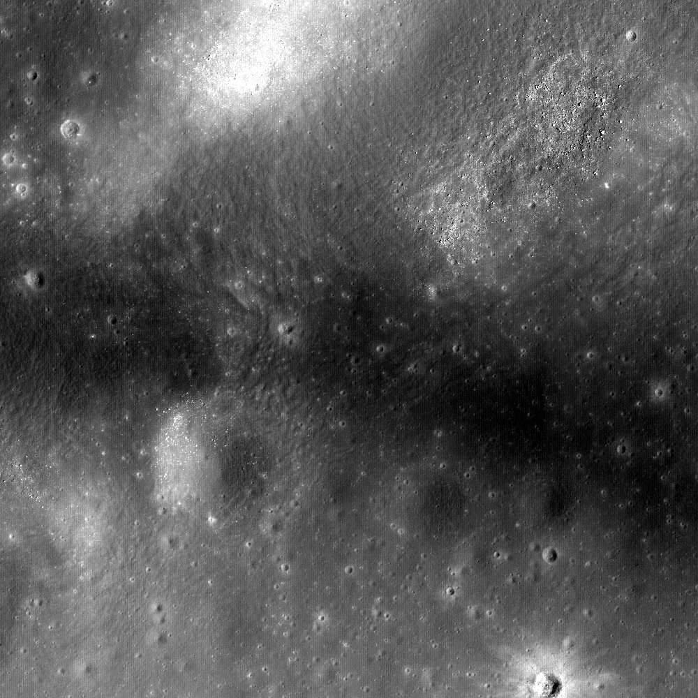
Far to the northeast of the more familiar heart of the Reiner Gamma albedo swirl (and magnetic anomaly) in Oceanus Procellarum, the bright but thin layer of optically immature regolith meanders up into the Marius Hills. The higher altitude assumed by the LRO mission this year allowed the diffuse contact region to be photographed in one observation, under the same lighting conditions. The LROC Wide Angle Camera 100 meter global mosaic is used as context for that area, swept up in the NAC observation below [NASA/GSFC/Arizona State University]. 
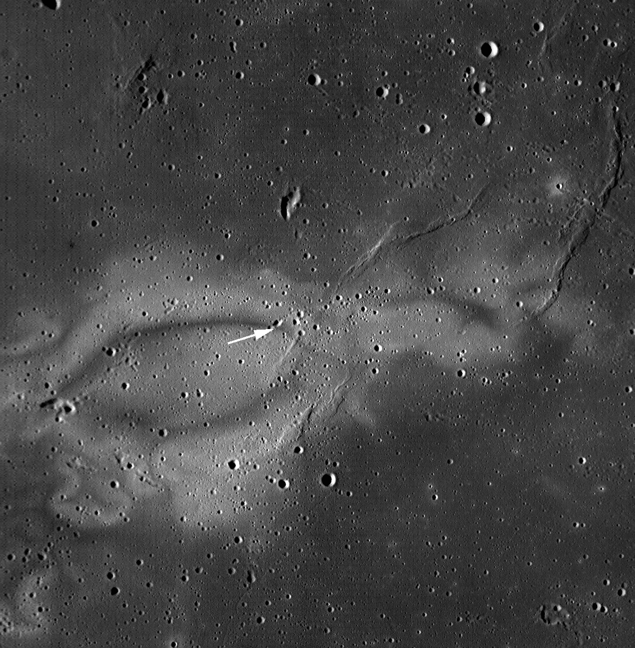
Still at high resolution, the physical relationship at the surface between the Reiner Gamma swirl and the Marius Hills volcanism can be studied under similar lighting condition, and in one take, in this LROC NAC mosaic. LROC NAC M1099209032LR, orbit 14337, August 10, 2012; resolution in the original 0.98 meters from 118.85 km, angle of incidence 40.15° [NASA/GSFC/Arizona State University].
"The 12th LROC Planetary Data System release includes images acquired between June 16 to September 15," according to the announcement, posted by LROC team member Ernest Bowman-Cisneros.

This LROC release totals 16.54 TB, and includes ten more Narrow Angle Camera (NAC) Digital Terrain Models (DTM) and 6 NAC image mosaics of important Region of Interest (ROI).

"To date," Bowman-Cisneros writes, "the LROC Team has delivered 893,493 LROC images and over 8,653 derived (RDR) data products to the NASA Planetary Data System. The complete LROC PDS archive can be accessed via the URL http://lroc.sese.asu.edu/data or a search for specific images or mosaics can be made using the LROC WMS browser. Also be sure and try out QuickMap!"

The anatomical mix of dark and relatively bright featured tossed up by simple craters impacting the Marius Hills can also be examined from the unique perspective presented in the LROC NAC oblique images, this one being the first we stumbled across, a brief study of the shield volcano's interior. LROC NAC M1096851065LR, LRO orbit 14007, July 13, 2012 [NASA/GSFC/Arizona State University].

Thursday, July 19, 2012

Bubble Bubble - Swirl and Trouble

Swirls in Mare Ingenii, far side of the Moon (LROC: The Swirls of Mare Ingenii, Brett Denevi, June 22, 2012.)  [NASA/GSFC/Arizona State University].
Paul D. Spudis
The Once and Future Moon
Smithsonian Air & Space

  
The Moon, unlike Earth, has no global magnetic field but many surface locales of limited extent (tens of kilometers across) are magnetized.  In many instances, these small areas of high magnetic intensity are associated with unusual patterns of surface brightness (albedo, or degree of reflectance) that occur in curved, blotchy or other strange “swirl-like” shapes.  First observed by telescope, lunar scientists have been puzzled by the possible origin of what they imaginatively named “swirls.”

An example of a lunar swirl is a feature named Reiner γ (pronounced “Reiner gamma”), a bright splotch in southern Oceanus Procellarum, the dark mare region of the western near side.  The name indicates that initially this feature was thought to be an isolated peak of highland material that juts up through the mare (lowercase Greek letters were assigned to such prominences in the old nomenclature.)  However, even at very low sun elevations, close examination shows that this bright patch does not cast a shadow.  It is simply a bright patch on the surface, one with diffuse and nebulous edges, yet clearly more reflective than the surrounding dark mare material.  It does not appear to be associated with any crater or other surface feature.  It’s as though someone smudged a finished painting of the lunar surface.

During later Apollo missions, orbiting vehicles released “sub-satellites” (small spacecraft that continued to orbit the Moon long after the crews had left for home) carrying instruments to measure the Moon’s magnetic field.  Interestingly, they found a very strong magnetic field enhancement around the Reiner γ feature.  Moreover, numerous other swirls were found elsewhere on the Moon, especially on the floor of the huge South Pole-Aitken (SPA) basin in Mare Ingenii on the far side, and on the eastern limb of the Moon near Mare Marginis.  Each newly seen swirl was found to be associated with a magnetic anomaly.  However, the converse statement is not true – not all magnetic anomalies have associated swirls.

Two principal models emerged to explain these relations.  One model held that the swirls and the magnetism were contemporaneous – the swirls were surficial deposits caused by the scouring of the surface during the impact of a comet.  In this model, the cometary coma (i.e., the dense gaseous “atmosphere” surrounding the icy nucleus) struck the Moon at high velocity, scouring the surface and increasing its brightness while at the same time embedding the soil with a strong magnetic field caused by the creation of an impact-generated plasma (high temperature, low density matter).

The other model suggested that the magnetic anomalies pre-dated and were the cause of the swirls.  The lunar surface darkens and becomes redder with time owing to exposure to the solar wind (the stream of energetic particles – mostly protons – from the Sun).  Strong, localized magnetic fields serve as protective “bubbles” that caused the incident solar wind to flow around these tiny areas, darkening the edges of the field bubbles with enhanced flow but preserving the inner zones (which were shielded from the solar wind) as bright patches.  Thus, the bright parts of the swirls are areas that have not undergone “weathering” by the solar wind while the dark parts are zones that have experienced excessive space weathering.

Magnetic bubble created in the laboratory [RAL/Univ. York].
It remained uncertain whether this postulated “magnetic bubble” effect would actually work but recent experiments suggest that these bubbles might well operate on the Moon.  Scientists from the UK’s Rutherford Appleton Laboratory, creating a “solar wind tunnel” to observe the interactions of streaming plasma and confined magnetic bubbles, successfully produced a magnetic bubble under simulated space conditions.  They have compared the flow field around the laboratory magnetic bubble with the observations from orbiting spacecraft of lunar surface magnetism and find that the solar wind would be diverted around these magnetic anomalies on the Moon.  If solar wind darkening is the primary process that darkens the surface, we may have an explanation for the creation of the bright swirls.

70 kilometer-wide field of view LROC Wide Angle Camera (WAC) mosaic swept up from two orbital passes in May 2010. (The yellow box show a roughly 2.5 km-wide LROC Narrow Angle Camera (NAC) field of view in the image below. Something is allowing the radiation-linked maturation of lunar regolith in the dark lanes of Reiner Gamma while continuing to keep dust at the surface of its bright albedo lanes fresh and optically immature. Though the local magnetic field is probably strong enough to refract solar radiation, it's not sufficient for repelling more energetic (and admittedly less frequent) cosmic rays. The latter should have sufficient time to redden (darken) or "mature" the bright regions over about 900 million years [NASA/GSFC/Arizona State University].

The astute reader will note that while this bubble model might account for the origin of the swirls, it begs the question about what caused the magnetic field anomalies in the first place.  That remains a mystery.  It was noted many years ago by my colleague Lon Hood of the University of Arizona that many of the magnetic anomalies on the Moon are at the antipodes (i.e., 180° away from the center) of some of the youngest, large impact basins on the Moon.  The largest concentration of both surface magnetic anomalies and swirls are on the floor of the large SPA basin, near Mare Ingenii on the lunar far side.  This area is directly antipodal to the large, young Imbrium basin on the near side.  Likewise, the Mare Marginis swirls and magnetic fields are antipodal to the Orientale basin on the western limb (the last of the large lunar multi-ring impact basins).  Furthermore, as basins tend to cover the entire Moon, one can find a basin near the antipodes of almost any given feature (note well: the swirl that started all this hubbub, Reiner γ, isn’t antipodal to anything in particular).  But an even more significant issue is that while the basin antipodal association of many swirls is intriguing, it does not explain why we should see a zone of enhanced magnetization at such locations.  Igneous intrusion, concentration of impact-generated plasmas and converging ballistic ejecta have all been proposed but no specific mechanism seems to emerge as the magnetic field creating event.

We are left with a continuing and highly unsatisfactory situation – a possible explanation for the development of surface swirls on the Moon and of their association with magnetic field bubbles, but we still don’t understand the origins of these fields, the cause of their shapes and intensities and how they fit into the continually vexing problem of lunar magnetism in general.  Two steps forward and one step back.   Lunar science marches on.

Originally published at his Smithsonian Air & Space blog The Once and Future Moon, Dr. Spudis is a senior staff scientist at the Lunar and Planetary Institute. The opinions expressed are those of the author and are better informed than average. 

Saturday, May 5, 2012

The new Kaguya Terrain Camera tours

Still from the 16:9 spectacular Kaguya terrain camera video tour of the Reiner Gamma albedo swirl in Oceanus Procellarum. The presentation does an excellent job showing the apparent link between the swirl and the morphology of the Marius Hill to its northwest [JAXA/SELENE].
Japan's space agency JAXA recently published a handful of spectacular, new highly realistic 3D tours from Terrain Camera data returned from SELENE-1 (Kaguya 2007-2009). Since Kaguya met its end in a guided impact visible from Earth in 2009, sporadic updates to the Kaguya Image Gallery, where mission science, presentations and a sampling of HDTV are available, have been few. 

The Japanese language side of the gallery is always updated first, so it took a little intuition for us to find the useful link to the new products. These are also comparatively large video files (20Mps MPEG, ~100 mg). Unable to view the best of these new presentations following the Flash linkage, the stand-alone files can download for viewing locally . It's worth the effort. A user can "right hand click" the links below to save the video files directly.


If you don't want to bother with all that and still want a renewed taste of Kaguya's still-unique and valuable contributions - not the least their addition to the aesthetics and appreciation for the beauty of Earth's Moon - don't neglect the Kaguya YouTube videos, starting with the famous Earthrise from 2008.

While in the neighborhood, a new and improved Kaguya terrain camera tour of the wider vicinity of the Marius pit, situated within a sinuous rille winding through the heart of the Marius Hills, is also worth the time.

Monday, February 6, 2012

LROC releases 57 narrow angle elevation models

False color model of the highest vents of the many Marius Hills now believed to be a single shield volcano in central Oceanus Procellarum, a region which may have remained active until 1.1 billion years ago. Nearby (bottom, north) is the tadpole head of the unofficially named "Sinuous Rille A." This area was a prime potential landing site in the Apollo era, more recently in the second tier of 50 Constellation Regions of Interest. The low profile of the Marius Hills, surrounded by relatively flat Procellarum mare, has made appreciating their anatomy difficult except after local sunrise and before local sunset when even low features cast long shadows. LROC Narrow Angle Camera photography taken from overhead and from a slewed angle in orbits before and after such opportunities has made it possible to build very high resolution models when the rare opportunity presents itself [NASA/GSFC/Arizona State University.
On January 15, the LROC team at Arizona State released 57 new high resolution digital terrain models (DTM). According to principal investigator Dr. Mark Robinson, "the new DTMs total about 170 Gbytes of data, and cover a variety of high science value targets."

"Start exploring today," Robinson urged. HERE.
The Marius Hills ROI (color strip closer to the horizon) in the context of LROC Wide Angle and Narrow Angle Camera photography showing a handful of the surrounding hills to the southwest and including the grayscale DTM of the Reiner Gamma albedo swirl over a 600 kilometer stretch of the Procellarum mare, a trail that seems to begin in those hills meandering to the famous central "eye" of Reiner Gamma, also a Tier 2 Constellation program Region of Interest and location of the Moon's most familiar crustal magnetic field. Since its discovery early in the history of nearside telescopic study observers have speculated whether the distinctive bright swirl of anomalously low optical maturity was accompanied by a topographic component. The grayscale DTM sliced through the dense "eye" of the formation appears to show nothing like a different crater count or change in elevation that explains the highly visible swirl, seemingly painted over the wide space of Procellarum mare.
The search for the once-elusive highest elevation on the lunar surface came to an end in the 21st century, first with the arrival of Japan's SELENE-1 (Kaguya) and soon confirmed by two digital elevation models under development using data from LRO laser altimetry (LOLA) and offset orbital photography from the LROC NAC and WAC instruments. Somewhat isolated from hills nearly as high along the northern outer rim of the ancient South Pole Aitken basin, north of the Korolev impact basin, this high promontory adjacent to the eastern wall of Engel'hardt crater on the Moon's farside tops out at 10,786 meters above global mean, almost 2 kilometers higher than Mt. Everest [NASA/GSFC/Arizona State University].
Explore the LROC Narrow Angle Camera Digital Terrain Models HERE.

Monday, October 17, 2011

LROC Quickmap improvements dazzle

Roof top of the Moon (10,786 meters (35,387 feet) above global mean elevation), as determined by LRO investigators a year ago, is high on the lopsided eastern rim of Engel'gardt crater (5.7°N, 159.0°E), in the farside highlands; 44 km-wide and seen here immediately left of center in a field of view roughly 325 km wide and includes the northern Korolev basin (below). All these features are difficult to spot in cameras, not least of the reasons being in an area criss-crossed with superimposed bright rays. After this past weekend, however LROC premiered an overlay with a variable opacity showing their Global Wide Angle Camera (WAC) digital terrain model (DTM) in false color (here seen at the default 30% over the hybrid LROC NAC and WAC Global mosaic) is now an integral part of the ACT-REACT LROC Quickmap feature on their popular website, improving the map's usefulness when searching through LROC's vast data contribution to the Planetary Data System immeasurably [NASA/GSFC/Arizona State University].
An hour "playing" with the 'new and improved' LROC Quickmap enabled us to assemble this exploration of the tenuous connection between the Marius Hills and the Reiner Gamma albedo feature (with it's attendant crustal magnetic anomaly), both familiar features in Oceanus Procellarum. It's a place to begin digging deeper into the three dimensions of data from LROC already available to the public, especially with the new addition of the LROC DTM. Is Reiner Gamma's long swirl and it's intense local magnetism a result of a sub-surface flash flood of volcanic material? With the new LROC DTM overlay, it's much easier to demonstrate those features with little to no corresponding topographic expression and others nearly invisible except at very high sun angles [NASA/GSFC/Arizona State University].
Not very far from the Moon's highest point is what appears to be it's lowest, within the South Pole-Aitken basin, at the bottom of the large crater on the southern floor of Antoniadi (or, near 70.38°S, 187.2°E, over 9,000 meters below global mean elevation). This mix of LROC WAC imagery overlaid with the false-color WAC DTM adds more than just a feeling of depth of field. Most camera views of the floor of Antoniadi, and mare-filled features everywhere else on the Moon, the surface looks misleadingly flat. Even at 500 meter per pixel resolution, the wide deep flat floor of Antoniadi shows an uneven, almost "dune-like" roughness, lost in surveys based on albedo alone [NASA/GSFC/Arizona State University].
Another instant study increases the opacity of the LROC WAC DTM overlay from the base WAC optical mosaic of a nearside portion of the lunar south pole environs, offering an informative look at one of the Moon's last terra incognitas [NASA/GSFC/Arizona State University].
Related Post: LROC Quickmap

Wednesday, October 12, 2011

Moon in UV sheds light on maturation and materials

One of four "enigmatic" domes singled out in a segment of an LROC Wide Angle Camera (WAC) color mosaic released at the European Planetary Science Congress and the American Astronomical Society's Division for Planetary Sciences on October 7. Long suspected of being a separate species from more common volcanic features, like those of the Marius Hills, the Darney C 3 domes ("D" on the second image following) on the border of Mare Cognitum with Oceanus Procellarum (11.22°S, 333.5°E) may, instead, be fragments of a long obliterated lunar crust or islands, once high places now nearly buried  by the flows that created the nearside's basins. LRO orbits 4559 and 4560, June 22, 2010; from 44.9 km altitude, resolution ~ 62.5 meters per pixel [NASA/GSFC/Arizona State University].

Editors Note: Fairly reliable elemental maps of the Moon have been around since the Apollo era, becoming more detailed as planetary scientists continue to comb through data obtained by Clementine (1994) and Lunar Prospector (1998-1999) (along with those of the flotilla of probes dispatched by ESA, Japan, India and China). The highest-resolution direct observations of the Moon are still being swept up by the record-shattering Lunar Reconnaissance Orbiter, now well into a third year in low lunar orbit and only beginning to show a degree of age after the loss of Mini-RF operations and a redundant gyro this past year.

In December LRO will be raised to a more stable 100 km-high orbit to save fuel after orbiting the Moon 11,000 times since arriving in lunar orbit in June 2009, and long after becoming the longest lasting lunar mission as well, returning more data than all previous Deep Space missions put together.

LRO teams continue to use earlier abaselines to map confirm the abundance of a variety of strategic elements on the lunar surface, and in unprecedented detail.A promise made for delivering such comprehensive high-resolution color maps and elemental surveys of the Moon is being fulfilled.

What follows is "value-added" detail from a widely-circulated press release about presentations made by the Lunar Reconnaissance Orbiter Camera (LROC) investigators to a joint meeting of the European Planetary Science Congress and the American Astronomical Society's Division for Planetary Sciences on October 7. Along with the elusive original demonstration images we've added a number of mosaics of images already released to the Planetary Data System.

From a partial map of the nearside lunar surface centered on the colorful contact zone bordering Mare Serenitatis and Mare Tranquillitatis, combining observations in visible and ultraviolet wavelengths and showing a 'treasure trove' of areas rich in titanium oxide. Titanium is a valuable element, key to helping scientists unravel mysteries of the Moon's interior. LROC investigators Mark Robinson and Brett Denevi presented the results at the European Planetary Science Congress and the American Astronomical Society's Division for Planetary Sciences on October 7. The relative blue color of the Tranquillitatis mare is due to a higher abundances of the titanium-bearing mineral ilmenite. Direct study of samples gathered by Cernan and Schmitt (Taurus Littrow, Apollo 17, December 1972) aided in establishing baselines for comparable elemental signatures. Enhanced color formed as 689 nm filter image in red, 415 nm in green, and 321 nm in blue. See the full size demonstration image HERE [NASA/GSFC/Arizona State University].
Titanium relative abundance mapped
by Clementine (1994).
From: EPSC/ASA Joint Meeting 2011 Press Notice - October 7
 
Subtly Shaded Map of Moon Reveals Titanium Treasure Troves

"Looking up at the Moon, its surface appears painted with shades of grey -- at least to the human eye. But with the right instruments, the Moon can appear colorful," said Mark Robinson, of Arizona State University. "The maria appear reddish in some places and blue in others. Although subtle, these color variations tell us important things about the chemistry and evolution of the lunar surface. They indicate the titanium and iron abundance, as well as the maturity of a lunar soil."

The Lunar Reconnaissance Orbiter Camera (LROC) Wide Angle Camera (WAC) is imaging the surface in seven different wavelengths at a resolution of between 100 and 400 metres per pixel. Specific minerals reflect or absorb strongly certain parts of the electromagnetic spectrum, so the wavelengths detected by LROC WAC help scientists better understand the chemical composition of the lunar surface.

Robinson and his team previously developed a technique using Hubble Space Telescope images to map titanium abundances around a small area centred on the Apollo 17 landing site. Samples around the site spanned a broad range of titanium levels.  By comparing the Apollo data from the ground with the Hubble images, the team found that the titanium levels corresponded to the ratio of ultraviolet to visible light reflected by the lunar soils.

“Our challenge was to find out whether the technique would work across broad areas, or whether there was something special about the Apollo 17 area,” said Robinson.

Robinson’s team constructed a mosaic from around 4000 LRO WAC images collected over one month. Using the technique they had developed with the Hubble imagery, they used the WAC ratio of the brightness in the ultraviolet to visible light to deduce titanium abundance, backed up by surface samples gathered by Apollo and Luna missions.

The new map shows that in the mare titanium abundances range from about one percent to a little more than ten percent. In the highlands, everywhere TiO2 is less than one percent. The new titanium values match those measured in the ground samples to about one percent.

From a full-resolution LROC Wide Angle Camera three-color composite (566 nm filter image in red, 360 nm in green, and 321 nm in blue), "Figure 2" accompanying the October 7 press release, highlighting regions with varying mare compositions and certain of the more "enigmatic" small volcanic domes. The area shown is a familiar nearside territory, west longitude from around 340° to 320° and from the equatorial landing sites of Apollo 12 and 14 down to 21° south. View the full size image accompanying the October 7 press release HERE  [NASA/GSFC/Arizona State University].
Designated by the letter "H" in 'Figure 2' immediately above is 'the Helmet," apparently the official designation for the enigmatic dome previously known as Agatharchides 1 (and "the Fireman's Hat) for the associated crater group, may be an island of ancient crust 60 km wide floating northeast of Mare Humorum (18.2°S, 328.9°E). Mosaic of three LROC WAC observations in the 643 nm band, January 27, 2011 [NASA/GSFC/Arizona State University].

“We still don’t really understand why we find much higher abundances of titanium on the Moon compared to similar types of rocks on Earth.  What the lunar titanium-richness does tell us is that the interior of the Moon had less oxygen when it was formed, knowledge that geochemists value for understanding the evolution of the Moon,” said Robinson.

Lunar titanium is mostly found in the mineral ilmenite, a compound containing iron, titanium and oxygen. Future miners living and working on the Moon could break down ilmenite to liberate these elements.  In addition, Apollo data shows that titanium-rich minerals are more efficient at retaining particles from the solar wind, such as helium and hydrogen. These gases would also provide a vital resource for future human inhabitants of lunar colonies.

“The new map is a valuable tool for lunar exploration planning. Astronauts will want to visit places with both high scientific value and a high potential for resources that can be used to support exploration activities. Areas with high titanium provide both – a pathway to understanding the interior of the Moon and potential mining resources,” said Denevi, from John Hopkins University.

Based on it's spectacular rays and highly reflective deeper anatomy Giordano Bruno (35.9°N, 102.8°E) had once been believed the result of a very recent event, perhaps even a famous 12th century phenomena witnessed and recorded by European monks. Though that theory fell by the wayside some time ago, LROC Wide Angle Camera UV imagery has shown optical maturity by solar UV radiation occurs more rapidly than previously understood. In the LROC WAC UV mosaic below, more or less matching the area shown above of global lunar albedo mosaic from the 1994 Clementine mission, the wider area affected by the G. Bruno event is far less dramatic [NASA/DOD/VMA6].
On the other hand, in the LROC global UV mosaic (Figure 3 from the Oct. 7 press release: Color Ratio 321 nm / 415 nm), the full extent of the Goddard/Mare Marginis albedo swirl, contrasts with it's background quite well. The coincident crustal magnetic anomaly is antipodal to Mare Orientale, which, though the youngest of the classic impact basins is still estimated at over 3 billion years old. This image adds evidence to the theory that lunar swirls associated with fossil magnetic fields must result from a more dynamic phenomena than merely deflection of solar radiation by magnetic fields. Shedding and retaining charged sub-micron regolith must, in no small part, be linked with the Moon's "daily" dusty atmospheric cycles [NASA/GSFC/Arizona State University].

The new maps also shed light on how space weather changes the lunar surface. Over time, the lunar surface materials are altered by the impact of charged particles from the solar wind and high-velocity micrometeorite impacts. Together these processes work to pulverize rock into a fine powder and alter the surface’s chemical composition and hence its colour.  Recently exposed rocks, such as the rays that are thrown out around impact craters, appear bluer and have higher reflectance than more mature soil. Over time this ‘young’ material darkens and reddens, disappearing into the background after about 500 million years.

“One of the exciting discoveries we’ve made is that the effects of weathering show up much more quickly in ultraviolet than in visible or infrared wavelengths.  In the LROC ultraviolet mosaics, even craters that we thought were very young appear relatively mature. Only small, very recently formed craters show up as fresh regolith exposed on the surface,” said Robinson.

SCIENCE CONTACTS:
Mark Robinson 
Arizona State University
School of Earth and Space Exploration
E-mail: robinson@ser.asu.edu
http://ser.sese.asu.edu/
Brett Denevi

The Johns Hopkins University
Applied Physics Laboratory
Brett.Denevi@jhuapl.edu 

Figure 4 from the October 7 press release compares the familiar Reiner Gamma swirl in the visual with the UV (right), as seen in LROC WAC mosaics. Nearside swirls differ from those on the farside. They are fewer and none are linked with basin-forming impacts on the opposite side of the Moon. The beauty of the swirl at Reiner Gamma and the much more vague bright albedo of the Descartes Formation are associated with the strongest crustal magnetic anomalies yet mapped. Reiner Gamma is almost certainly linked geologically with the Marius Hills. Regardless, in ultra-violet, Reiner y seems too fresh and too superficial for an airless body whose surface is gardened every 2 million years. The Moon's dusty surface may be migrating very slowly, but it is surely on the move [NASA/GSFC/Arizona State University].
A seventy kilometer-wide field of view LROC WAC mosaic swept up during two orbital passes last May. The yellow box show the roughly 2.5 km-wide Narrow Angle Camera field of view shown in the last image, below. Something is allowing the radiation-linked maturation of lunar regolith in the dark lanes of Reiner Gamma and continually keeping the dust at the surface of its bright albedo fresh and optically (and UV) "immature." The intense crustal magnetism closely incidental with this very long but very superficial swirl anomaly may be linked to sub-surface flows of melt and remelted materials originating in the Marius Hills, where the swirl has a clear terminus, 200 kilometers to the northeast. Though the local magnetic field may be intense enough to refract solar radiation it is insufficient at repelling more energetic (or, admittedly less frequent) cosmic rays. Though less frequent, the latter would have had sufficient time to mature the brighter regions over the last 900 million years. Instead, it was proposed in 2008 by one of us (and more recently by Carle Pieters, et.al.) that a far more dynamic, seasonal and daily cycle of lunar dust formation, charging, discharging and relentless migration is being disrupted at these locations [NASA/GSFC/Arizona State University].
LROC Narrow Angle Camera (NAC) observation M114342150L, LRO orbit 1984, December 1, 2009 [NASA/GSFC/Arizona State University].
how to make gif
Juxtaposed LROC WAC mosaics of the Lassell dome formation designated with the letter "L" in the third image from the top in this posting, Figure 2 from the October 7 press release. From LRO orbital observations under different angles of incidence.  M129350040CE, orbit 4195, May 24, 2010 (phase angle 55.94°) and M147041474CE, orbit 6803, December 15, 2010 (phase angle 76.89°) [NASA/GSFC/Arizona State University].

Saturday, August 13, 2011

Recent impact near Reiner Gamma


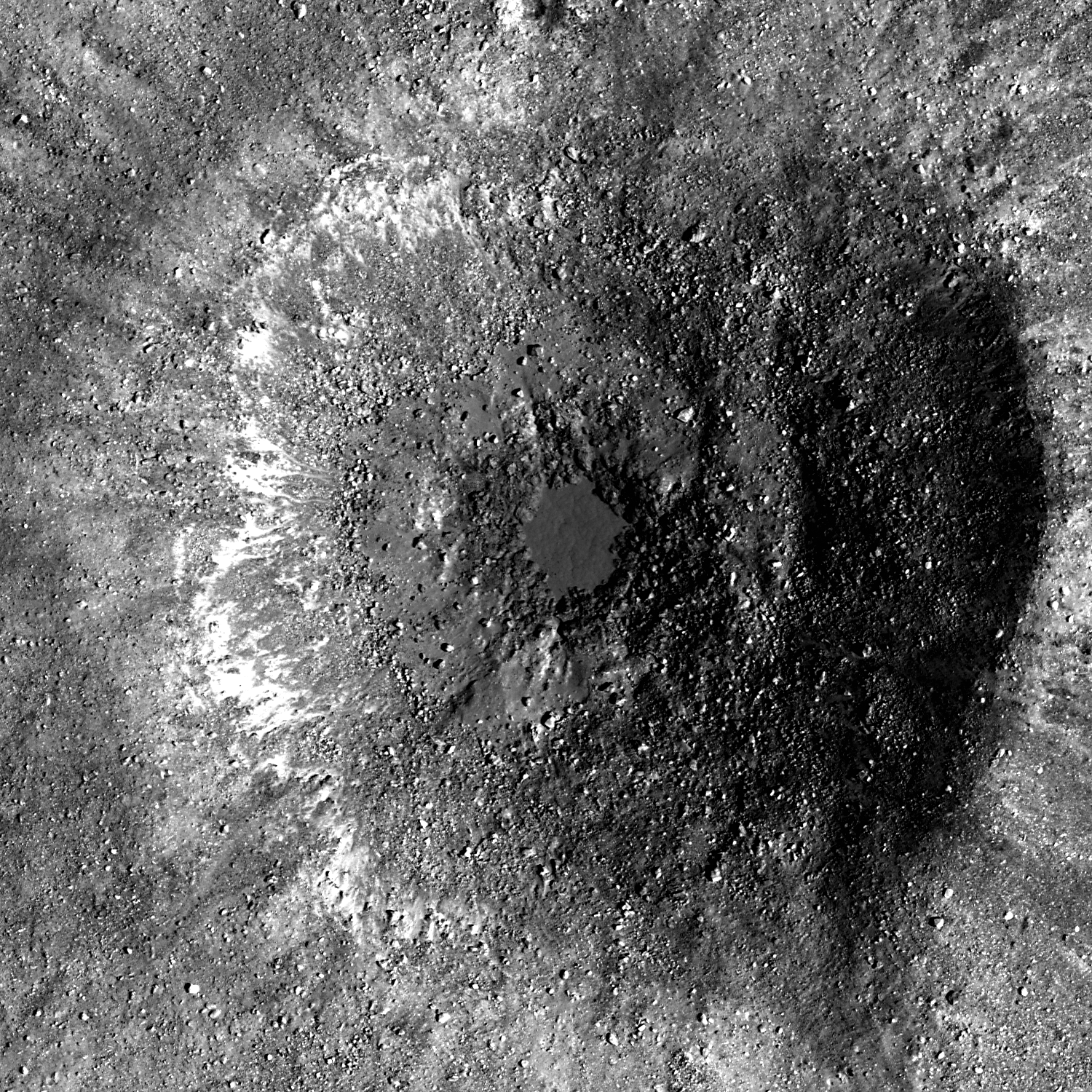
An exaggerated close-up of an apparently unmarked pool of impact melt marking the bulls-eye floor of what must be a very fresh crater at a geologic crossroads in Oceanus Procellarum. Sampling in and around this "dig" would add to our knowledge of the Reiner Gamma albedo swirl and magnetic anomaly, the Marius Hills to the north, nearby Reiner crater and the vast Procellarum basin itself [NASA/GSFC/Arizona State University].


The small amount of impact melt pooled and froze becoming the 90 x 70 meter floor of this Copernican Age crater. What process creates impact melt pools? LROC Narrow Angle Camera (NAC) observation M111972680LE, LRO orbit 1635, November 4, 2009; image field of view is 750 meters. View the full 1500 pixel-wide LROC Featured Image HERE [NASA/GSFC/Arizona State University].

Drew Enns
LROC News System
Link
This unnamed crater is near the Reiner Gamma Swirl in Oceanus Procellarum. The crater’s relative youth makes it a great example to investigate how impact craters form. The cratering process occurs in three stages: contact and compression, excavation, and modification. The impact melt and boulders were created during contact and compression as the bolide transferred its kinetic energy to the target.


The ejecta blanket of the unnamed crater. Image is a mosaic of NAC pair M111972680, image width is 3.0 km [NASA/GSFC/Arizona State University].

The ejecta blanket was deposited during the excavation stage, covering the surrounding mare surface with high reflectance, immature material. The modification stage brought about the final shape of the crater. As the forces involved in the impact subsided, the impact melt pooled at the bottom of the crater along with the boulders. The modification stage is still ongoing as gravity has since caused small landslides on the crater wall, and more boulders have probably eroded out of the crater wall.

Can you find similar craters in the full NAC frame?


The arrow notes the location of the relatively recent crater enfolded by the wispy anomalous albedo of Reiner Gamma, the Moon's most extensive such "swirl," in this 125 km-wide monochrome (643 nm) LROC WAC mosaic. The small crater is also situated near the end of a secondary crater chain radiant of the Reiner crater impact zone, just peaking into view at lower right. A wider field of view can be viewed HERE [NASA/GSFC/Arizona State University].

Related Posts:
Rubble Pile on Fresh Crater Floor
Action Shot
Melt and more melt


It's not inconceivable that the small but bright (optically immature) impact crater northeast of the "eye" of Reiner Gamma could be imaged from Earth. For a variety of reasons it is invisible in this spectacular mosaic captured by the Astonominsk partnership on September 25, 2008. Neither are many other lower profiled features characteristic of the Procellarum basin anatomy [Astronominsk].

Monday, August 8, 2011

LROC: Tendrils etched in Reiner's rim


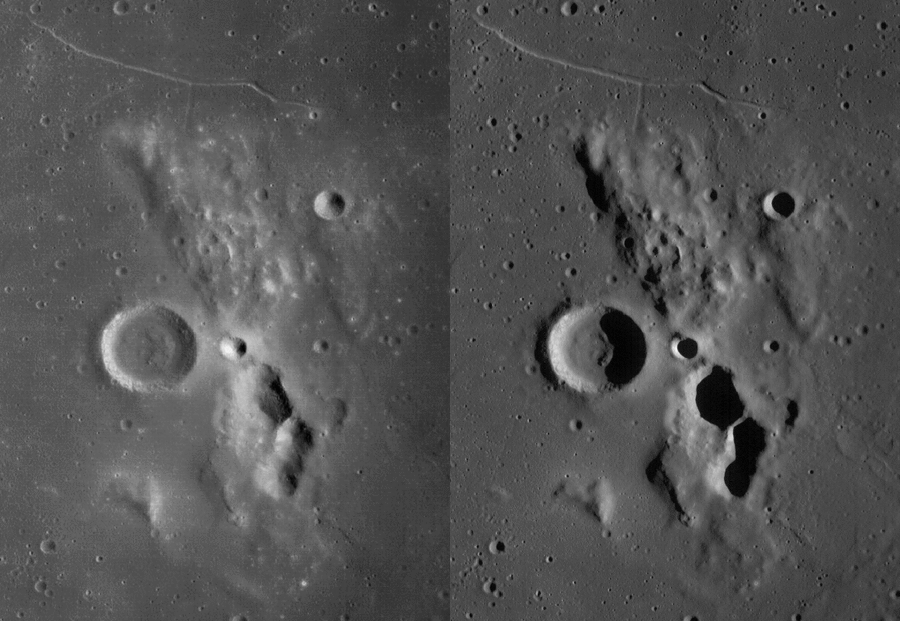
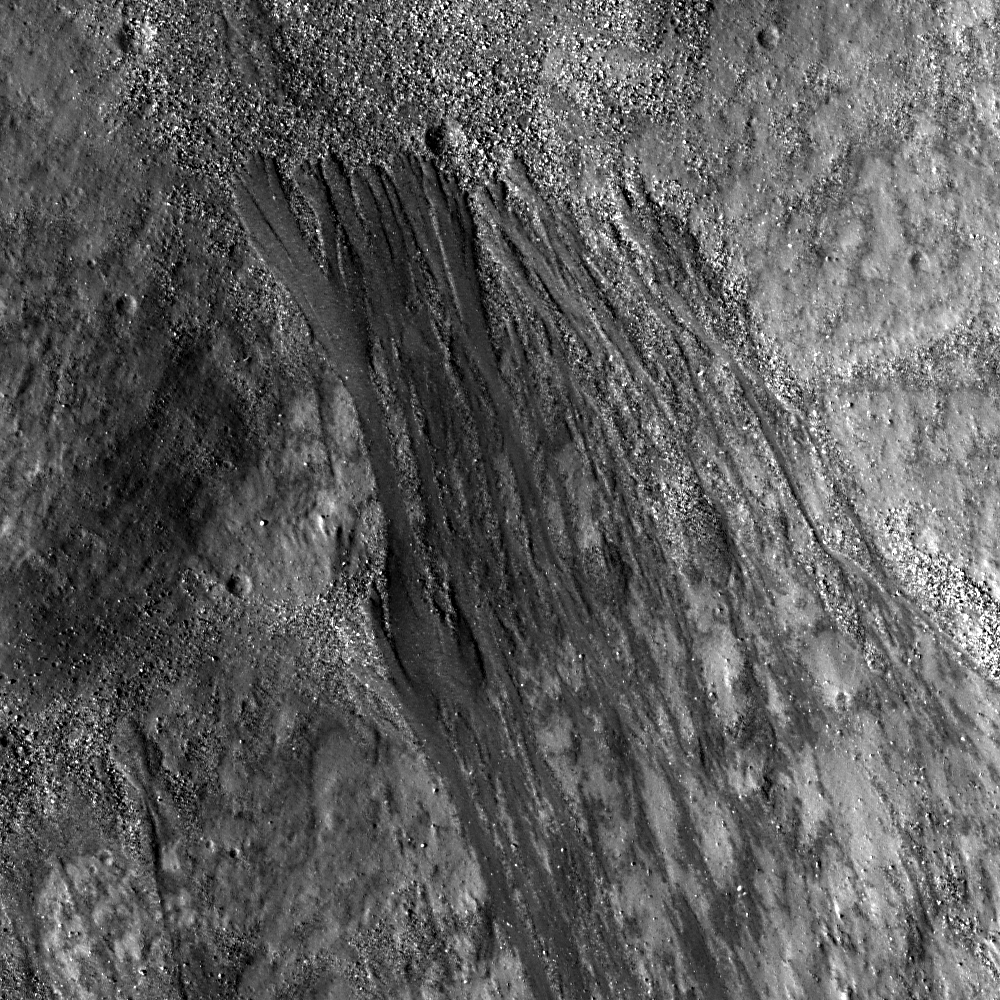
Elongate flows formed during their race towards the floor of Reiner crater, and boulders piled up at their base. Are the flows impact melt or something else? (Downslope is to the upper left.) LROC Narrow Angle Camera observation M135548391LE, LRO orbit 5109, August 4, 2010; field of view 500 meters, See the full-size LROC image release HERE. The tendrils etched into Reiner's inner rim are also easily seen in LROC Observation M142625106L, imaged October 25, 2010 [NASA/GSFC/Arizona State University].

Drew Enns
LROC News System

Reiner crater (6.9°N, 305.0°E) in Oceanus Procellarum is Eratosthenian in age because it does not have a visible, high-reflectance ejecta ray system like Copernicus or Tycho craters. Today's Featured Image focuses on the southern wall of Reiner crater.

The flows emplaced along the crater wall are reminiscent of some impact melt features seen on the Moon. They are elongate, slightly lobate, and have many boulders that could have weathered out of them. And they do appear to have flowed downwards into the crater, solidifying on the wall before reaching the crater floor. But are the flows impact melt?


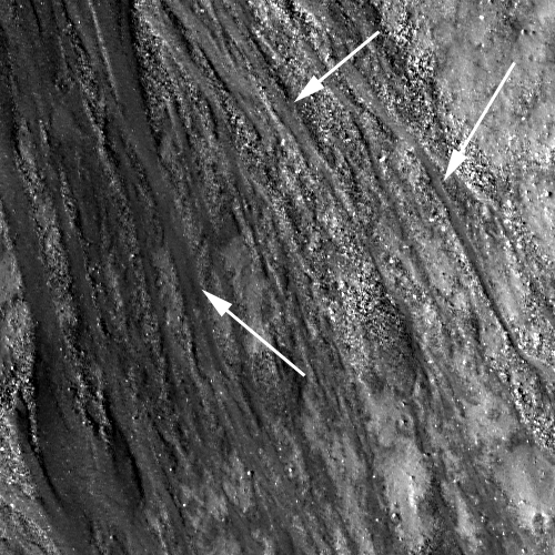
Arrows point to incisions cut into the crater wall by these flows, image field of view 250 meters [NASA/GSFC/Arizona State University].

The elongate morphology of these flows is also similar to that of a dry debris flow. Impact melt would only have the chance to flow downhill once before solidifying, but the flows appear to have been deposited successively during multiple flow periods. Furthermore, the flows also cut through loose material on the crater wall, indicating that the flows formed more recently. These relationships are perhaps more consistent with dry debris flows, than impact melt flows.

Can you find more flows in the full NAC frame?


LROC Wide Angle Camera (WAC) monochrome (604nm) mosaic stitched together over four orbital observational opportunities (orbits 5108-5111) at the same as that of the LROC NAC image from which the LROC Featured Image, August 8, 2011, was processed a little over a year earlier. A portion of the Reiner Gamma lunar crustal magnetic anomaly, with its attendant swirl, a long streaming surficial albedo running from the Marius Domes to the north, southwest to the western edge of Oceanus Procellarum, is visible at upper left [NASA/GSFC/Arizona State University].

Related Posts:
Dry debris or liquid melt?
Splash and flow
Rootless impact melt

Monday, May 16, 2011

Online: The Lunar Mapping and Modeling Project (LMMP)


No longer 'no man's land,' the Moon's south pole and vicinity unseen before the 21st century swept up by laser altimetry over multiple orbital passes of the LOLA instrument on-board the Lunar Reconnaissance Orbiter (LRO). Most of the lower elevations shown above are permanently shadowed. This false-color and hill-shade view of the LOLA Digital Elevation Model (DEM) is a small example of what can now be very easily accessed on-line by way of the Lunar Mapping and Modeling Project (LMMP), already a very thorough public resource under development by NASA.

Kimberly Newton
Marshall Space Flight Center

NASA has created a new interactive web-based tool that incorporates observations from past and current lunar missions creating one of the most comprehensive lunar research websites to date.

The Lunar Mapping and Modeling Project at NASA's Marshall Space Flight Center in Huntsville, Ala. has created an online set of capabilities and tools that will allow anyone with an Internet connection to search through, view, and analyze a vast number of lunar images and other digital products. The data and tools available through the project website will allow researchers to perform in-depth analyses to support mission planning and system design for lunar exploration and science missions. It will permit detailed scientific analysis and discovery and open additional educational and outreach opportunities.

The project website is a one-stop location for finding, retrieving, and analyzing data about the moon, including the most recent lunar surface imagery, altimetry, temperature, lighting and other data, as provided by the Lunar Reconnaissance Orbiter (LRO) and its seven onboard instruments.


A postage-stamp-sized reduction of the LMMP user interface as viewed through most browsers shows the LOLA color-coded and hillside shaded elevation of 75 degrees south layered over, in this example, the LROC Wide Angle Camera (WAC) monochrome mosaic [NASA].

The orbiter, launched by NASA in 2009, continues to gather information about the moon from its orbit some 31 miles (50 kilometers) above the lunar surface. LRO has provided a treasure trove of data -- more than all previous lunar and planetary missions combined.

The Lunar Mapping and Modeling Project website will also include data obtained from past lunar programs and missions including Apollo, Lunar Orbiter, Lunar Prospector, Clementine, Kaguya (Japan) and Chandrayaan-1 (India).

Read the full-story HERE.


On the other hand, some lunar features can only be seen to be appreciated. As previously demonstrated, the Reiner Gamma lunar swirl, a nearside landmark in Earth-side telescopes, is invisible in the LMMP LOLA DEM layer, but shows up instantly when, with a click of the mouse, the present LMMP base map Lunar Orbiter/Clementine hybrid photomap is brought to the surface.

Friday, October 15, 2010

Reiner Gamma in color

From LRO Wide Angle Camera
Actually a combination of three wavebands (566, 604, 643nm) of seven swept up by the LROC Wide Angle Camera (WAC) observation M122597745CE during LRO orbit 3201, March 7, 2010. The natural color here is less luminous, though the red cast when compared to similar mare basalts appears to be an actual aspect outside the anomalous low optical maturity of the enormous swirl albedo here, stretching over 500 km across the floor of Oceanus Procellarum [NASA/GSFC/Arizona State University].


Reiner Gamma and it's traces into the heart of the Marius Hills volcanic feature, southeastward to the western edges of Oceanus Procellarum [NASA/GSFC/Arizona State University].

Wednesday, June 30, 2010

Another look at Reiner Gamma


The heart of the Constellation Region of Interest in the Reiner Gamma swirl. Astronauts exploring this region will address longstanding questions about the origins of this distinctive natural feature. Image field is 510 meters across [NASA/GSFC/Arizona State University].

Bashar Rizk
LROC News System

First identified by early astronomers during the Renaissance, the Reiner Gamma formation has been a subject of intense scientific study for almost five decades and is one of the highest-priority targets for future human lunar exploration.

Reiner Gamma is one of the most distinctive natural features on the Moon. This striking, tadpole-shaped swirl has a significantly higher reflectance than the surrounding mare basalts.

-
LROC Wide-Angle Camera monochrome context image of the Reiner Gamma swirl. (Arrow indicates approximate location of the Narrow-Angle Camera detail above.) The field of view is approximately 80 km (M117874527ME) [NASA/GSFC/Arizona State University].

Several LROC Featured Images have shown spectacular new images of the swirls near Mare Ingenii which are similar to the swirls of Reiner Gamma. Reiner Gamma, however, is the "prototypical" lunar swirl.

A concept that comes up frequently in lunar science is "space weathering." This term is used to describe a suite of natural processes (including micrometeoroid impacts and exposure to solar wind) that can alter the spectral properties of lunar surface materials.

Since the reflectance of the lunar surface within the Reiner swirl is so different from the surrounding mare, some process may have altered the space weathering susceptibility of the swirl materials. There are several theories to account for the presence of the Reiner Gamma swirl. Results from previous lunar missions (including Lunar Prospector) have indicated that the swirl region has an elevated magnetic field, so it's possible that an event hundreds of millions of years ago modified the magnetic properties of the surface materials, deflecting the solar wind and changing how the reflectance is modified by space weathering.


The most familiar lunar swirl graces the western expanse of Oceanus Procellarum, as seen from Earth. The crater Reiner (right, center) is 31 km across. [Astronominsk, September 2007].

Some investigators have proposed that the coma of a comet - streaking in just above the surface - interacted with the lunar surface, changing the surface properties to the degree where the Reiner Gamma swirl could persist for millions of years.

However, based on the available data, we just don't know for sure! That's not a bad thing; if we knew all the answers to all of these interesting problems, we wouldn't ever need to explore! We will not know what caused the swirls of the Reiner Gamma formation until human explorers return to this region to do the fieldwork and collect the samples that will enable us to answer this fundamental scientific question.

Plan your own adventure to the enigmatic swirls of Reiner Gamma! Think about where you would go to answer these scientific questions!

For more information on LROC's observation campaign for the Constellation program regions of interest read this Lunar and Planetary Science Conference abstract, and visit the LRO Science Targeting Meeting website (look for the baseball card summary sheets for each site: part 1, part 2).


Magnetic field lines associated with Reiner Gamma at 35.5 km, as measured from Lunar Prospector (1998-1999), traced on Clementine (1994) 'natural color' mosaic. (Units are nT) - Varieties of Lunar Swirls, Blewett, Hughes, Hawke & Richmond, 38th Lunar and Planetary Science Conference (2007), Abstract #1232.

Local Topography and Reiner Gamma
May 22, 1010

Lunar Swirl Phenomena from LRO

May 17, 2010

Heart of Reiner Gamma
November 17, 2009

Saturday, May 22, 2010

Local Topography and Reiner Gamma


Just what is "Reiner Gamma?" What characteristics does this well-known and most studied of the so-called 'swirl' markings on the Moon share with the countless other, similar bright albedo markings found on its surface? What puts Reiner Gamma in a class by itself? It's meandering and complex pattern seems finely printed like a photograph negative on the very surface along a 380 km-long path in the western Oceanus Procellarum, from among the Marius Domes southwest to the mountains of the ocean's edge. LRO laser altimetry (LOLA Image of the Week, released May 21) seems to confirm the position held by most observers that Reiner Gamma is without "topographic expression," invisible to high-resolution laser point elevation surveys from low orbit. However, LRO photographs centered on Reiner Gamma in the longest shadows of local sunrise appear to show, however briefly, a very shallow set of ridges and other features corresponding to the swirl phenomena, and LOLA investigators were hasty in concluding otherwise [NASA/GSFC/LOLA].

Since 1979 we've amassed three volumes filled with studies as part of an effort to understand so-called "swirl" phenomena on the Moon. Not surprisingly, a majority of that work centers on Reiner Gamma, the atypical stain of "ray-like" bright material stretching across the western Oceanus Procellarum and immediately obvious to any of those pioneering few who first traced out the features of the Moon's near side after the development of the telescope. For any feature there to stand out as being in a class by itself meant Reiner Gamma Anomaly (RGA) had to truly be unique.

In the modern era, or at least since the Moon's far side and more complete views its western and eastern hemispheres, and the context of the entire Moon's surface, became a part of our understanding of the Moon following the opening of the Space Age, scientists have come to see Reiner Gamma as merely the most grand example of so-called swirl phenomena. Other markings that share Reiner Gamma's signature characteristics were discovered all over the Moon, particularly in the middle latitudes south of the equator on the far side and in similar latitudes in the north along the eastern limb, as seen from Earth, particularly in around Mare Marginis and Goddard.

Remote spectrography, orbital photography and other instrumental surveys of the surface strongly infer a link between the bright bifurcated swatches of these relatively bright "anomalous albedo" markings with patches of crustal magnetism viewed as equally anomalous on a Moon where little or no global magnetic field is found.


Above is a modern global examination of lunar magnetic anomalies, showing the correspondence between some of the more intense clusters of local field lines to be veritable shadows, existing at the antipodes, of the most familiar impact basins on the near side. On the nearside, however, where locally intense magnetic clumps detected at low orbital altitudes exist over both Reiner Gamma in the west and over the Descartes mountains south and east of the central meridian, no such mirror relationship with a "basin-forming impact" has been found.

In addition, both of these near side magnetic anomalies appear to carve out "mini-magnetospheres" that are intense enough to cavitate the solar wind and interplanetary magnetic field, just as Earth does on a much larger scale. Among the far side's more numerous crustal magnetic field clusters, the clump "antipodal" to Mare Crisium also demonstrates intriguing evidence of a mini-magnetosphere.


Nearside equatorial swirls not linked with any shocking impact that occurred at polar opposite locations on the Moon's far side, unlike those opposite Mare Imbrium, for example, which dominates the top of this Full Moon as seen from Earth. Reiner Gamma has always stood out from the dark "optically mature" and smooth basin floor of Oceanus Procellarum. Though comparatively bright, the albedo swirls of the southern central highlands, over Descartes and northwest of Airy craters were unambiguously identified as swirl phenomena after attendant magnetic anomalies were detected in data collected from low, end-of-mission orbital altitude by Lunar Prospector (1998-1999).

Rare phenomena on the Moon's near side, equatorial albedo swirls are draped on the surface of the Moon apparently without regard to the nature of the topography upon where they lay, are clearly linked to locally intense magnetic fields. The lunar surface has been shown generally unable to resist space weathering and a roughly 2 million year cycle of micrometeorite gardening or, in particular, a dark reddening that should obliterate a ray system like that of Tycho, longer than about 900 million years.

Since the swirls of Mare Ingenii on the southern far side are linked to "basin-forming impacts" events nearly 4 billion years old, how do they stay stubbornly fresh? These magnetic fields have been shown, especially where intense enough to cavitate voids in the solar wind, to be sufficient to buffer against that most pervasive of weathering caused by solar particles and solar particle events. But even the strongest of these present no hedge against relativistic cosmic rays, for example, or micro-meteor bombardment.

The answer is not the influence of comets or cometary tails, as some have long suggested. Rather, there now appears to be evidence of a link with the deposition of peculiar kinds of the nanophase iron found everywhere on the Moon, perhaps made peculiar by the influence of the magnetic anomalies themselves, and daily transport of newly-gardened alternately ionized sub-micron-sized lunar dust. Still, the nature of the Moon's local magnetism is clearly not the same in every situation. Perhaps something a little different is happening at Reiner Gamma.


Oceanus Procellarum, 'the Ocean of Storms,' still poses mysteries. It's not round, for one thing, though it might be part of the remains of the hypothetical 'Gargantuan' impact, older and much larger even than four billion-year-old South Pole-Aitken (SPA) Basin. If confirmed, estimates gauge the Gargantuan 'event' to have created a basin larger than half the Moon centered on what today is northwest Mare Tranquillitatis. It's offered as explanation for, among other things, more obvious differences in character between the Moon's near and far sides.

Reiner Gamma is seen here in context, it's distinctive "eye" pooling just left, or west, of bottom center and rope-like streamers running from the southwest and northwest into the very middle of the Marius Hills., Those volcanic domes, seen here below center as hair-like structures on the north side of the ring of lava-inundated Marius, south of Aristarchus Plateau, have been proposed as vents of a single shield volcano that Chinese scientists have named Yutu. [Astronominsk/LPOD].


From it's distinctive central 'eye," Reiner Gamma's long uninterrupted northeastward streamer reaches into the heart of 'Yutu," directly among the low Marius Hills. That seems to link RG with underground phenomena, with sub-surface morphology and perhaps even with the network that includes the Harayuma Skylight 'cave' entrance. Unlike most lunar magnetic anomalies, the low optical maturity of materials on the surface within its influence at Reiner Gamma is not yet linked with any massive impact on the polar opposite side of the Moon. Unlike most lunar swirls, RG is lengthy, and even indirectly linked with the very widespread and sustained volcanism centered at Yutu, Aristarchus Plateau, Rümker, the Gruithuisen domes, etc., there's enough evidence for a link just shy of scientific certainty. [LO-IV-157-H2/NASA/JPL/USGS].

So how did we get sidetracked by Reiner Gamma? Well, originally we set out to complete a discussion about the unique swirl on the Descartes mountains, begun on May 11 in "The still-mysterious Descartes formation" and continued in Lunar Swirl Phenomena and the LRO on May 17. The latter and this copiously illustrated post include a lot of the background for that work which we have put off again for one reason only.

On Friday, May 21, Goddard Space Flight Center released the excellent LRO laser altimetry (LOLA) elevation survey of Reiner Gamma shown at the top of this article., accompanied by a Clementine (1994) albedo photography of precisely the same area. In the text of their release was the hasty assertion that "there appears to be no correlation between the Reiner Gamma swirl and its local topography."

This was not quite what we expected, though taken as a conclusion about most lunar swirls, including most of Reiner Gamma, the statement make perfect sense. In most cases there appears to be little to no connection between swirls and local topography. Dark bands regularly bifurcate anomalous bright albedo swirls that drape over hills and in and out of craters all over the Moon, like ghosts, or as though they fell like salt shaken from overhead, and most of Reiner Gamma is no exception.

V.V. Shevchenko of Sternberg State Astronomical Institute in Moscow, long a proponent of the "recent cometary influence" theory concerning the origin of Reiner Gamma, has pointed to a faint structure of increased crater count that overlaps a seemingly uninterrupted background noise of craters that is apparently coincident with some of the eastern side of Reiner Gamma's huge eye. This is definitely seen in earlier laser altimetry of the area and again in the LOLA image release on Friday.

Of course, This only very slight change in cratering character could be coincidental. Ordinarily, we would be ready to agree that the huge Reiner Gamma swirl has no surface component. The conclusion is actually news worthy, believe it or not, because the "extremely thin" swirl characteristic is said to hold up even in the unprecedented resolution made possible by the LRO laser altimeter. But during our review of data for the Descartes discussion, we encountered a wide angle camera image also swept up by the Lunar Reconnaissance Orbiter.


The portion of LROC Wide-Angle Camera image M116696805MC showing the area of Oceanus Procellarum corresponding to the eye (7.4°N, 301°E) and northeastern "streamer" of the Reiner Gamma formation, running south-southwest of the Marius Hills region, December 29, 2009 (LRO Orbit 2331). At local sunrise, LRO was at an altitude of 45.42 km and the resolution is 64.73 meters per pixel (LRO-lunar surface-Sun phase angle = 90.1°) [NASA/GSFC/Arizona State University].


The portion of LROC WAC M114342152CE showing a slightly slewed view of the 'central eye' of Reiner Gamma, December 1, 2009 (LRO Orbit 1984). It is early mid-morning, LRO altitude = 45.61 km, resolution = 64.82 meters per pixel; LRO-Subject-Sun phase angle = 60.51°

These two images really have to be seen in full and studied with some care, comparing crater with crater, to appreciate the magnitude of relief, allowing some very shallow features to be visible only in the long shadow available in the above image.

Both of these should be available at their maximum available size simply by clicking on the images themselves.

In the image below is the heart of Reiner Gamma at a level of clarity already equal to the previously unprecedented assembly of data put together from Japan's SELENE-1 (Kaguya) Terrain Camera. It's difficult, perhaps impossible at a quick glance to pick out any crater count above background corresponding to the surface albedo. A similar preliminary conclusion seems likely after examining cross-sections of the area available in LROC narrow-angle camera images at widely varying angles of solar incidence.

In the image above, a prominent set of ridges trail across the area that clearly follow, perhaps even channel, the original flow of molten material which may have induced a strong magnetism that may be at its strongest, today, on the eastern side of the eye. These features and others are clearly local topography that corresponds to the Reiner Gamma swirl.