Showing posts with label Lunar Surface Albedo. Show all posts

Sunday, November 23, 2014

Dark splotches over high albedo, under a high sun

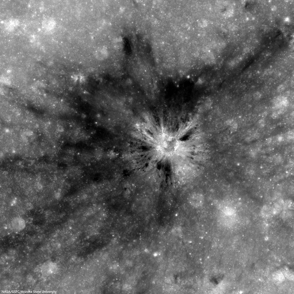
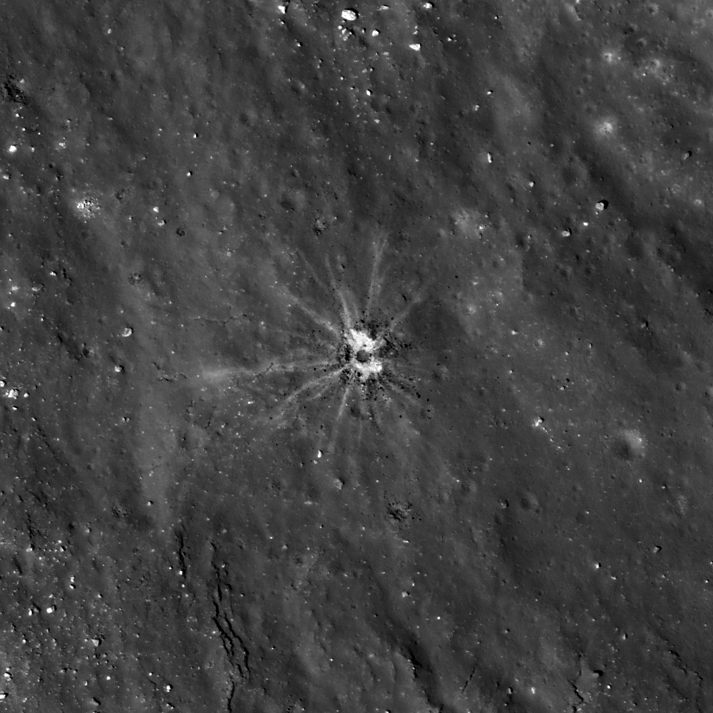
Unnamed crater (2.2784°N, 116.2125°E) southwest of King, presenting a unique albedo variation in 1.8 km-wide field of view from LROC NAC observation M123812230R, LRO orbit 3380, March 21, 2010; 8.3° incidence angle, resolution 57 cm from 55.36 km over 2.25°N, 116.16°E [NASA/GSFC/Arizona State University].
Hiroyuki Sato
LROC News System

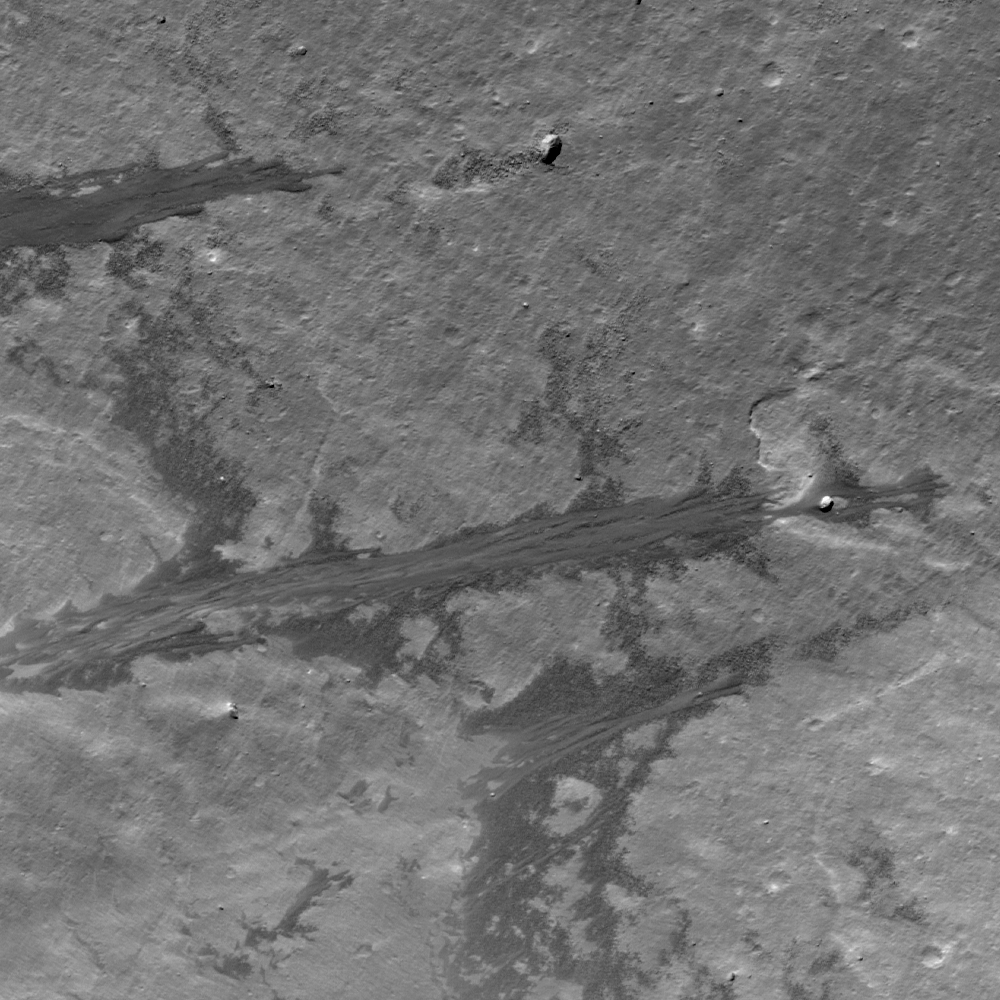
Impact craters routinely excavate subsurface materials, exposing them in crater walls and in ejecta. The Featured Image highlights an unnamed fresh crater (480 meters in diameter) with numerous dark splotches.

Inside the crater cavity, dark splotches (low reflectance materials) occur from the middle to the trim of the crater and spread outward beyond the rim crest.

Several small craters (less than 100 meters in diameter) with similar dark splotches also occur in this region (outside the area shown above, see next image), suggesting that the dark materials were likely excavated from an extensive subsurface layer. The distribution of the dark halo craters informs us about the horizontal extent of these subsurface materials.

Small craters a few thousand meters north of the dark halo crater (DHC) of interest, above, from the same LROC NAC frame M123812230R. Note the crater right of center bottom may be superposed on the rim of a more ancient depression [NASA/GSFC/Arizona State University].
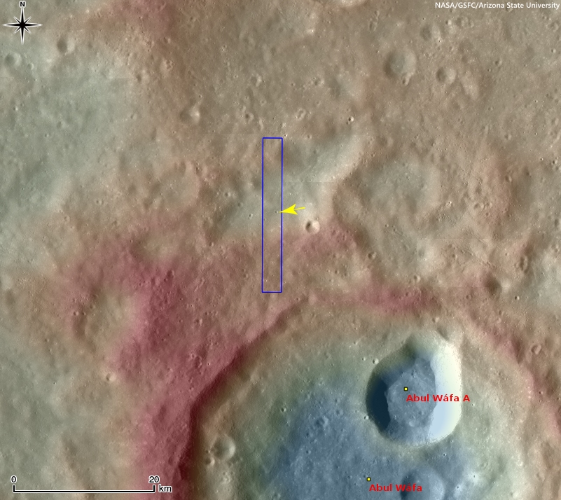
The crater in the opening image is found 116 km from the southwestern rim of King crater (76.2 km; 4.96°N, 120.49°E), located in the farside highlands. Unlike in the mare, pyroclastic deposits are unlikely to be the low-reflectance material (seen in the opening image) here in the middle of the highlands with no indication of volcanic activity near here. So, what is this low reflectance layer?

Context view of the location of today's Featured Image in WAC monochrome mosaic (100 m/pix) overlayed by WAC stereo DTM (GLD100, Scholten et al., 2012). The NAC footprint (blue box) and the exact location of the opening image (yellow arrow) are indicated [NASA/GSFC/Arizona State University]. 
The rays of Necho crater (36.87 km; 5.25°S, 123.24°E) extend out around 680 kilometers (see image below) crossing over King crater and the area in today's Featured Image. Since the area of opening image is crossed by the Necho ray deposits the excavated dark layer might be the original mature surface (now covered by Necho's high reflectance rays).  

Context view of the area of interest in an orthographic LROC WAC mosaic of low-angle observations of the surrounding hemisphere. Arrow points to the location of the crater of interest, within range of ejecta from King, Necho or perhaps, less likely, Giordano Bruno or Goddard A craters, (not unlike the magnetic anomaly east of Firsov) [NASA/GSFC/Arizona State University]. 
Due to the lack of atmosphere on the Moon, the photometric effect is very strong. Thus, it is hard to identify the relationships between the different layers using low-Sun images (images with large incidence angles, near sunrise or sunset); however, high-Sun images (those with low incidence angles, near noon) display clearly the relationships between units, which helps us reconstruct the resurfacing history of this area.

View full-size view of the LROC NAC frame, HERE.

Related Posts:

Tuesday, March 12, 2013

Not your average crater

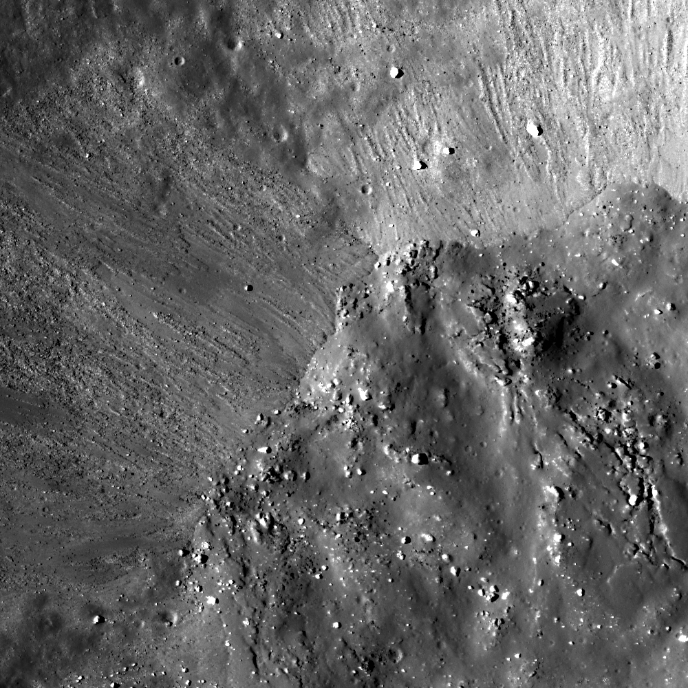
An asymmetric impact crater (14.349°S, 350.977°E) on the Lassell Massif revealing low reflectance material. NAC frame M152939732L, LRO orbit 7672, February 21, 2011; incidence angle 17.58° from the northwest, resolution 0.49 meters per pixel over a field of view approximately 820 meters across, from 39.65 km [NASA/GSFC/Arizona State University].
James Ashley
LROC News System

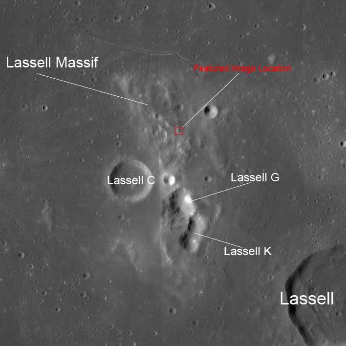
This week's Featured Images focus collectively on a region of the Moon known to present a ruddy discoloration through the eyepiece of ground-based telescopes (and also directly to the eyes of Apollo Command Module pilots). Known colloquially as "lunar red spots," such areas include the Gruithuisen Domes, Mons Hansteen, and the Helmet region. The red spot under observation this week is the Lassell Massif. This fascinating feature is a highstanding region of the Lassell Complex, located within the Alphonsus A basin in northeastern Mare Nubium, and consists of a rugged (though somewhat muted), hilly terrain, and several large, steep-walled depressions.

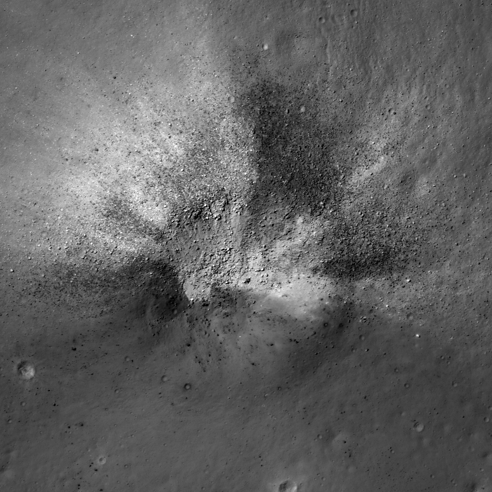
Today's Featured Image shows a striking impact crater in the northern hills of the massif. The crater exhibits an asymmetrical ejecta pattern, suggesting it to be the result of an oblique impact. The crater outline and ejecta distribution may also have been influenced by the uneven local topography. More geologically intriguing than this crater's shape, however, are the intermixed high and low reflectance materials excavated by the impact.

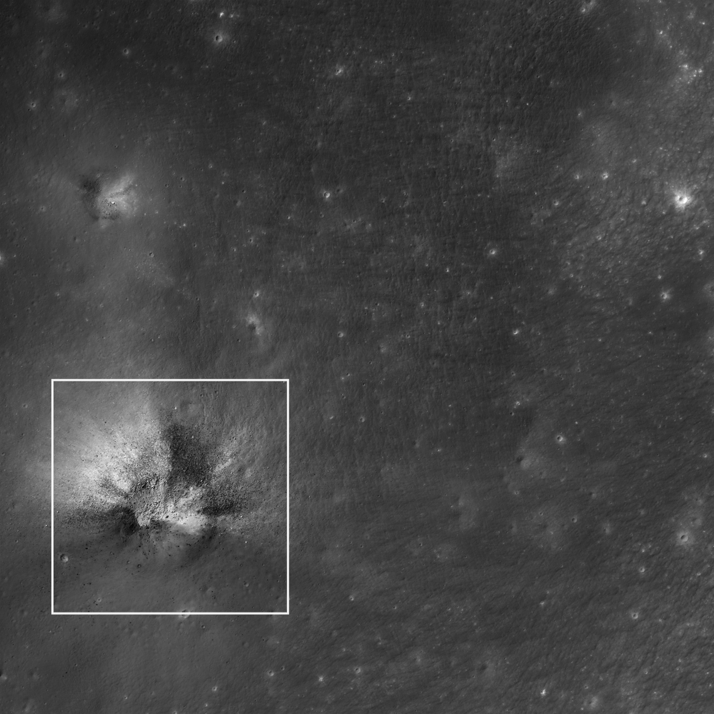
This wider field image from the same NAC frame shows an adjacent impact (northwest quadrant) to have excavated similar dark materials in the region; white square is the Featured Image location. Image is ~2.2 km wide [NASA/GSFC/Arizona State University].
The low reflectance materials (here seen as blocky) are suspected to be pyroclastic in origin, which speaks to the volcanic history of the Moon. Lassell crater itself (lower right in context image above) was described as being a source of pyroclastic materials since telescopic mapping efforts of the 1960s and '70s. The Lassell Massif is arguably close enough to this (and potentially other mare sources) to have received a share of these materials on the summits of its hills. Alternatively the central depressions on the massif may themselves be volcanic vents.

WAC mosaic context image. The white box outlines the area shown in the second image following above, field of view roughly 67 kilometers across [NASA/GSFC/Arizona State University].
While most lunar volcanism produced basaltic rocks, recent evidence is suggesting that Lassell Massif and other red spot areas are silica-rich, iron-poor volcanic deposits -- perhaps similar to the kind of volcanism we see with the Long Valley Caldera on Earth. While darker deposits tend to indicate an iron-rich material, their presence among silica-rich materials (which might seem like a geologic contradiction) may actually be suggestive of complex volcanism, where a variety of volcanic deposits are possible, and for which the Long Valley volcanics remain a good example.

What are the high reflectance materials seen distributed outward from the crater? Likely we are seeing ancient highland anorthositic material excavated from beneath an overlying volcanic deposit(s). What a fascinating spot for a future explorer!

From a 2010 demonstration, animation of separate LROC WAC observations of the geologically interesting Lassell Massif and crater group east of Lassell D, showing the latter's fresh ray system intruding from the west. This is more easily discerned under a high Sun while topography is easier to view under a mid-morning Sun in the east-northeast. The bright, widespread ejecta streamers from Lassell D alternates with a visible chevron affect by the Lassell D pressure front [NASA/GSFC/Arizona State University].
The next two Featured Image posts will include a brief discussion of this type of volcanism on the Moon, and explore some of the clues scientists are using to probe the Lassell Massif area. See the full NAC frame HERE. Other examples of pyroclastic deposits include DMD Excavations, Pyroclastic Trails, and Pyroclastic Excavation.

Thursday, July 19, 2012

Bubble Bubble - Swirl and Trouble

Swirls in Mare Ingenii, far side of the Moon (LROC: The Swirls of Mare Ingenii, Brett Denevi, June 22, 2012.)  [NASA/GSFC/Arizona State University].
Paul D. Spudis
The Once and Future Moon
Smithsonian Air & Space

  
The Moon, unlike Earth, has no global magnetic field but many surface locales of limited extent (tens of kilometers across) are magnetized.  In many instances, these small areas of high magnetic intensity are associated with unusual patterns of surface brightness (albedo, or degree of reflectance) that occur in curved, blotchy or other strange “swirl-like” shapes.  First observed by telescope, lunar scientists have been puzzled by the possible origin of what they imaginatively named “swirls.”

An example of a lunar swirl is a feature named Reiner γ (pronounced “Reiner gamma”), a bright splotch in southern Oceanus Procellarum, the dark mare region of the western near side.  The name indicates that initially this feature was thought to be an isolated peak of highland material that juts up through the mare (lowercase Greek letters were assigned to such prominences in the old nomenclature.)  However, even at very low sun elevations, close examination shows that this bright patch does not cast a shadow.  It is simply a bright patch on the surface, one with diffuse and nebulous edges, yet clearly more reflective than the surrounding dark mare material.  It does not appear to be associated with any crater or other surface feature.  It’s as though someone smudged a finished painting of the lunar surface.

During later Apollo missions, orbiting vehicles released “sub-satellites” (small spacecraft that continued to orbit the Moon long after the crews had left for home) carrying instruments to measure the Moon’s magnetic field.  Interestingly, they found a very strong magnetic field enhancement around the Reiner γ feature.  Moreover, numerous other swirls were found elsewhere on the Moon, especially on the floor of the huge South Pole-Aitken (SPA) basin in Mare Ingenii on the far side, and on the eastern limb of the Moon near Mare Marginis.  Each newly seen swirl was found to be associated with a magnetic anomaly.  However, the converse statement is not true – not all magnetic anomalies have associated swirls.

Two principal models emerged to explain these relations.  One model held that the swirls and the magnetism were contemporaneous – the swirls were surficial deposits caused by the scouring of the surface during the impact of a comet.  In this model, the cometary coma (i.e., the dense gaseous “atmosphere” surrounding the icy nucleus) struck the Moon at high velocity, scouring the surface and increasing its brightness while at the same time embedding the soil with a strong magnetic field caused by the creation of an impact-generated plasma (high temperature, low density matter).

The other model suggested that the magnetic anomalies pre-dated and were the cause of the swirls.  The lunar surface darkens and becomes redder with time owing to exposure to the solar wind (the stream of energetic particles – mostly protons – from the Sun).  Strong, localized magnetic fields serve as protective “bubbles” that caused the incident solar wind to flow around these tiny areas, darkening the edges of the field bubbles with enhanced flow but preserving the inner zones (which were shielded from the solar wind) as bright patches.  Thus, the bright parts of the swirls are areas that have not undergone “weathering” by the solar wind while the dark parts are zones that have experienced excessive space weathering.

Magnetic bubble created in the laboratory [RAL/Univ. York].
It remained uncertain whether this postulated “magnetic bubble” effect would actually work but recent experiments suggest that these bubbles might well operate on the Moon.  Scientists from the UK’s Rutherford Appleton Laboratory, creating a “solar wind tunnel” to observe the interactions of streaming plasma and confined magnetic bubbles, successfully produced a magnetic bubble under simulated space conditions.  They have compared the flow field around the laboratory magnetic bubble with the observations from orbiting spacecraft of lunar surface magnetism and find that the solar wind would be diverted around these magnetic anomalies on the Moon.  If solar wind darkening is the primary process that darkens the surface, we may have an explanation for the creation of the bright swirls.

70 kilometer-wide field of view LROC Wide Angle Camera (WAC) mosaic swept up from two orbital passes in May 2010. (The yellow box show a roughly 2.5 km-wide LROC Narrow Angle Camera (NAC) field of view in the image below. Something is allowing the radiation-linked maturation of lunar regolith in the dark lanes of Reiner Gamma while continuing to keep dust at the surface of its bright albedo lanes fresh and optically immature. Though the local magnetic field is probably strong enough to refract solar radiation, it's not sufficient for repelling more energetic (and admittedly less frequent) cosmic rays. The latter should have sufficient time to redden (darken) or "mature" the bright regions over about 900 million years [NASA/GSFC/Arizona State University].

The astute reader will note that while this bubble model might account for the origin of the swirls, it begs the question about what caused the magnetic field anomalies in the first place.  That remains a mystery.  It was noted many years ago by my colleague Lon Hood of the University of Arizona that many of the magnetic anomalies on the Moon are at the antipodes (i.e., 180° away from the center) of some of the youngest, large impact basins on the Moon.  The largest concentration of both surface magnetic anomalies and swirls are on the floor of the large SPA basin, near Mare Ingenii on the lunar far side.  This area is directly antipodal to the large, young Imbrium basin on the near side.  Likewise, the Mare Marginis swirls and magnetic fields are antipodal to the Orientale basin on the western limb (the last of the large lunar multi-ring impact basins).  Furthermore, as basins tend to cover the entire Moon, one can find a basin near the antipodes of almost any given feature (note well: the swirl that started all this hubbub, Reiner γ, isn’t antipodal to anything in particular).  But an even more significant issue is that while the basin antipodal association of many swirls is intriguing, it does not explain why we should see a zone of enhanced magnetization at such locations.  Igneous intrusion, concentration of impact-generated plasmas and converging ballistic ejecta have all been proposed but no specific mechanism seems to emerge as the magnetic field creating event.

We are left with a continuing and highly unsatisfactory situation – a possible explanation for the development of surface swirls on the Moon and of their association with magnetic field bubbles, but we still don’t understand the origins of these fields, the cause of their shapes and intensities and how they fit into the continually vexing problem of lunar magnetism in general.  Two steps forward and one step back.   Lunar science marches on.

Originally published at his Smithsonian Air & Space blog The Once and Future Moon, Dr. Spudis is a senior staff scientist at the Lunar and Planetary Institute. The opinions expressed are those of the author and are better informed than average. 

Friday, June 22, 2012

LROC: The Swirls of Mare Ingenii

An oblique view of Mare Ingenii and the swirl that marks its floor. Scene is approximately 15 km across (subsampled from the native resolution); LROC Narrow Angle Camera (NAC) frames M191830503L & R, LRO orbit 13304, May 16, 2012; resolution 2.95 meters per pixel. See the full size LROC Featured Image HERE [NASA/GSFC/Arizona State University].

Brett Denevi
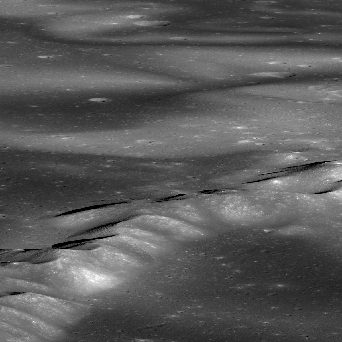
Lunar swirls are among the most beautiful and bizarre features on the Moon. Seen as bright, sinuous regions, swirls are associated with weak magnetic anomalies in the Moon's crust. Images from LROC, and the topographic information extracted from those images, have shown that swirls have no topography associated with them; they are not higher or lower than their surroundings. Instead, it is as if someone has taken a brush and laid down a beautiful swath of bright paint. In the top image is the classic omega-shaped swirl of Mare Ingenii, also seen in this past featured image. The region of higher terrain is the rim of Thompson crater.

The lavas that formed Mare Ingenii flooded Thompson, leaving only the rim as a kipuka of older highland terrain.

A wider (but very reduced-resolution) view of the Ingenii swirls. The rims of Thompson and Thompson M craters are seen in the foreground. View is from east to west, and the full scene is approximately 58 km across [NASA/GSFC/Arizona State University].
The obvious question: how did swirls, like the one shown here, form? The leading hypothesis involves two main components - solar wind and crustal magnetic anomalies. The solar wind is a stream of charged particles coming from the Sun that normally interact with the Moon's surface, darkening it as one portion of a process called space weathering. On the Earth, the magnetic field acts as a shield and usually deflects the solar wind (when it doesn't, the solar wind interacts with the atmosphere, causing the northern lights). The Moon lacks a global magnetic field, but does have small, local magnetized regions within the crust. This is where we see the swirls. So the idea is that these local magnetic fields prevent the solar wind from doing its normal job of space weathering, and the surface stays bright. The stunning swirly pattern of the bright regions is likely due to the complex pattern of the magnetic field lines, which shield some areas and not others.

LROC Wide Angle Camera (WAC) views of Mare Ingenii, for context. The box in the second image outlines the approximate footprint of the LROC Featured Image released June 21, 2012. The bottom animated gif image, generated from separate views of the 282 km wide Mare Ingenii and the 1400 square km surrounding region from the LROC QuickMap. Resolution was set at 500 meters, WAC mosaic draped over the WAC derived elevation model Researchers long suspected true lunar albedo swirls are not related to any topographic feature, including very small secondary craters. The latest high resolution images and crater count studies continue to back that conclusion.  [NASA/GSFC/Arizona State University].
The LROC team is continuing to study the lunar swirls, including their color properties as observed in LROC Wide Angle Camera data, to learn more about how swirls form, the process of space weathering, the rate at which bright, freshly exposed material is darkened by space weathering, and why crustal magnetic fields are where they are.

See the spectacular full-resolution oblique look at the Ingenii swirls HERE.

Read about the Reiner Gamma swirl, HERE.

Mare Ingenii was imaged using the HDTV camera on-board Japan's lunar orbiter Kaguya (SELENE-1) in 2008 [JAXA/NHK/SELENE].
Mare Ingenii Related Posts:
The new Kaguya Terrain Camera tours (May 5, 2012)
A Potpourri of Lunar Results (March 14, 2012)
NASA@Science: “Down the lunar rabbit hole (July 13, 2010)
Grand lunar swirls yielding to LRO Mini-RF (October 4, 2010)
Depths of Mare Ingenii (June 16, 2010)
LROC: Ingenni Swirls at Constellation ROI (May 26, 2010)
More cavern entrances discovered on the Moon (February 26, 2010)
Moon’s mini-magnetospheres are old news (November 16, 2009)

Thursday, May 31, 2012

LROC: A Beautiful Impact on the rim of Lomonosov

Young impact craters often present a striking array of tones in their ejecta. Illumination is from the southeast, image is ~500 m across, LROC Narrow Angle Camera (NAC) observation M156964572L, LRO orbit 8266, April 9, 2011; resolution 0.55 meter over an incidence angle of 29.68° from 53.1 kilometers. View the larger LROC Featured Image HERE [NASA/GSFC/Arizona State University].
James Ashley
LROC News System

Yesterday's Featured Image post focused on regolith of contrasting reflectivity within the ejecta blanket of a 3 kilometer in diameter lunar impact crater.

Today's post shows another example of recently disturbed lunar regolith, but associated with a crater only 80 meters in diameter.

Impacts from space debris occur randomly across the lunar surface, and the target for this event just happened to be a fault slump along the high western wall of Lomonosov crater in the farside highlands.

The white square shows the Featured Image location within a larger context portion of LROC NAC frame M156964572L. Image is ~2.4 km across. [NASA/GSFC/Arizona State University].

Once again we see space-weathered, low-albedo deposits mixing with fresher ("optically immature") materials of higher albedo excavated from beneath the surface layer.

Because of space weathering the Moon is actually a relatively dark object in the solar system. Its overall low reflectance is not apparent to the human eye when seeing the Moon from Earth at night because the Moon is in direct sunlight against the inky black background of Space. In spacecraft images showing the Earth-Moon system (properly exposed as a pair) the low albedo of the Moon becomes obvious.

The WAC mosaic shows the field of view in the LROC Featured Image released May 31, 2012 high on the west rim of Lomonosov (arrow), almost two kilometers higher in elevation relative to the Moon's global mean than the mare inundated floor of the 108 kilometer wide crater. The simulated view juxtaposes the LROC Wide Angle Camera (WAC) 100 meter Global Mosaic imagery with LOLA laser altimetry using the ILIADS application from NASA's Lunar Mapping and Modeling Project (LMMP) -  simulated view from 45 km over the Moon south-southwest of Lomonosov  [NASA/GSFC/Arizona State University].
Lomonosov may be a highland crater, but its floor more closely resembles a mare deposit, being composed of a smooth lava plain. Compare Lomonosov with Plato crater in the 29 May 2012 post. Some of the brighter patches of material in the northernmost portion of the floor are ejecta from the young crater Giordano Bruno to the northeast, demonstrating once again the effects on albedo that recent craters can have.

Examine the full NAC frame HERE. Additional examples of recent small craters can be found in On the Shore of the Bay of Rainbows, in Recent Impact in Oceanus Procellarum, and Crater in 3D!

Saturday, May 5, 2012

Hubble: using moonlight to study Venus transit

A reduced resolution sample of an image from the Hubble Space Telescope, trained upon bright 109 million year old Tycho , with its hemisphere-wide ray system visible to the naked eye from Earth. A rare time when Hubble and human sight overlap. When Venus transits across the disk of the Sun a month from now, a rare event which will not occur again until 2117, Hubble will be trained on the Moon, using very subtle variations in the reflected sunlight to analyze Venus and its atmosphere [NASA/ESA/D. Ehrenbach (IPAG)].
This mottled landscape showing the impact crater Tycho is among the most violent-looking places on our Moon. Astronomers didn't aim NASA's Hubble Space Telescope to study Tycho, however. The image was taken in preparation to observe the transit of Venus across the Sun's face on June 5-6.

Hubble cannot look at the Sun directly, so astronomers are planning to point the telescope at the Earth's moon, using it as a mirror to capture reflected sunlight and isolate the small fraction of the light that passes through Venus's atmosphere. Imprinted on that small amount of light are the fingerprints of the planet's atmospheric makeup.

These observations will mimic a technique that is already being used to sample the atmospheres of giant planets outside our solar system passing in front of their stars. In the case of the Venus transit observations, astronomers already know the chemical makeup of Venus's atmosphere, and that it does not show signs of life on the planet. But the Venus transit will be used to test whether this technique will have a chance of detecting the very faint fingerprints of an Earth-like planet, even one that might be habitable for life, outside our solar system that similarly transits its own star. Venus is an excellent proxy because it is similar in size and mass to our planet.

The astronomers will use an arsenal of Hubble instruments, the Advanced Camera for Surveys, Wide Field Camera 3, and Space Telescope Imaging Spectrograph, to view the transit in a range of wavelengths, from ultraviolet to near-infrared light. During the transit, Hubble will snap images and perform spectroscopy, dividing the sunlight into its constituent colors, which could yield information about the makeup of Venus's atmosphere.

Hubble will observe the Moon for seven hours, before, during, and after the transit so the astronomers can compare the data. Astronomers need the long observation because they are looking for extremely faint spectral signatures. Only 1/100,000th of the sunlight will filter through Venus's atmosphere and be reflected off the Moon.

This image, taken with Hubble's Advanced Camera for Surveys, reveals lunar features as small as roughly 560 feet (170 meters) across. The large "bulls-eye" near the top of the picture is the impact crater, caused by an asteroid strike about 100 million years ago. The bright trails radiating from the crater were formed by material ejected from the impact area during the asteroid collision. Tycho is about 50 miles (80 kilometers) wide and is circled by a rim of material rising almost 3 miles (5 kilometers) above the crater floor. The image measures 430 miles (700 kilometers) across, which is slightly larger than New Mexico.

Because the astronomers only have one shot at observing the transit, they had to carefully plan how the study would be carried out. Part of their planning included the test observations of the Moon, made on Jan. 11, 2012, as shown in the release image.

Hubble will need to be locked onto the same location on the Moon for more than seven hours, the transit's duration. For roughly 40 minutes of each 96-minute orbit of Hubble around the Earth, the Earth occults Hubble's view of the Moon. So, during the test observations, the astronomers wanted to make sure they could point Hubble to precisely the same target area.

This is the last time this century sky watchers can view Venus passing in front of the Sun. The next transit won't happen until 2117. Venus transits occur in pairs, separated by eight years. The last event was witnessed in 2004. [NASA/ESA/Ehrenreich,  IPAG/CNRS/Université Joseph Fourie].

Tuesday, April 17, 2012

LROC: Rays from Tiny Crater

A 30 meter diameter crater with pronounced rays. LROC Narrow Angle Camera (NAC) observation M169723917L, orbit 10146, September 3, 2011, resolution 0.47 meters from 38.3 kilometers. Image field of view is 290 meters, centered on 12.929°N, 127.671°E. North is up, angle of incidence 25.5° View the 500 meter field of view in the original LROC Featured Image release HERE [NASA/GSFC/Arizona State University]
Hiroyuki Sato
LROC News System

Radial streaks which extend out from impact craters are called rays, and are commonly observed on the surface of the Moon, Mercury, Mars, and satellites of the outer planets. Today's Featured Image highlights a tiny crater (about 30 meters diameter) with clearly visible rays composed of high reflectance material, and is about 70 km east of Meshcherskiy crater (60.2 km in diameter). The small crater is located on the ejecta blanket of unnamed immature (young) crater about 8.7 km in diameter. It appears to have excavated through an impact melt deposit at 3.4 km from the rim of this fresh and larger crater.

The small crater rim exhibits many blocks (boulders), which indicates the target material was composed of hard material (in this case hardened impact melt from the 8.7 km crater). Perhaps the rays were formed as late stage ejecta was directed around the blocks on the rim? So many craters to investigate? One lesson from the NAC images is that small craters are expressed in many forms dependent on target material, impact angle, impact speed, and perhaps other unknown factors!

The final shape of a small crater is greatly influenced by the mechanical properties of the target material (e.g. Regolith on Basalt, Fresh Bench Crater in Oceanus Procellarum, Just Another Crater?, Bench Crater in Plato, Crater Covered With Boulders!). As mentioned above, today's Featured Image crater is located on the impact melt sheet produced from the adjacent unnamed immature crater. The layered structure of target surface, which might consist of rigid and brittle impact melt on top of unconsolidated ejecta debris, both originating from the larger crater, could have contributed to the rays of the smaller crater.

Context for the LROC Featured Image, released April 27, 2012: Wide Angle Camera (WAC) monochrome mosaic centered on unnamed immature crater northeast of Meshcherskiy , in the farside lunar highlands. Image centered on 13.08°N, 127.57°E. NAC footprint (blue box) and the location of the area detailed in the Featured Image (white arrow) are indicated. View the full-size WAC context image HERE [NASA/GSFC/Arizona State University].

Explore the rays of this tiny crater and surrounding morphology/geology by full NAC frame yourself, HERE.

Related Posts:
Nature's Art
On the Shore of the Bay of Rainbows
Ray of boulders
Asymmetric Ejecta
Apollo 14 S-IVB Impact Crater
Bright Crater Rays and Boulders

Wednesday, March 14, 2012

A Potpourri of Lunar Results

Mare inundated interior of Thompson P, part of the larger Mare Ingenii, home of one of the more enigmatic lunar magnetic anomalies and surficial albedo swirls. The tenuous markings and the crustal magnetism are nearly antipodal (on the direct opposite side of the Moon) from Mare Imbrium, the nearside's most easily recognized impact basin. Ingenni is also situated just within the edge of the Moon's oldest, deepest and largest known impact, the South Pole Aitken basin. Did the magnetic field here result from the Imbrium of SPA event, or both? The yellow arrow marks the location of the Ingenni pit crater [NASA/GSFC/LMMP/Arizona State University].
Kelly Beatty
Sky & Telescope

It's been nearly 40 years since astronauts returned the last Apollo samples from the Moon (and 35 since Luna 24 brought back 170 grams from Mare Crisium). Since then several orbiting spacecraft have mapped the lunar surface from top to bottom, repeatedly. So a casual observer might conclude that we've learned everything there is to know about the Moon.

Ha! If anything, questions about how Earth's satellite formed and evolved are more numerous than ever. As evidence, I submit the following summaries of research that's been published in the past few weeks.

Read the full feature article HERE.

Saturday, February 25, 2012

LROC: Impact melt boundary and Moltke

Dry debris flows terminate on the cracked and bouldery melt sheet in Mare Tranquillitatis landmark crater Moltke, 43 kilometers southeast of the landing site of Apollo 11. A textural change marks the boundary between crater wall and impact melt deposits embaying the crater floor. Image field of view 1100 meters. Credited as LROC Narrow Angle Camera (NAC) observation M122591558L, orbit 3200, March 7, 2010; resolution 0.5 meters from 40.63 km. View the full size LROC Featured Image (labeled M183360570RE) HERE [NASA/GSFC/Arizona State University].
Drew Enns
LROC News System

In the absence of an absolute age date, lunar scientists have to rely on the geomorphology of a crater to determine how old it is relative to other craters. The sharpness of the deposits in today's Featured Image is a good indicator that Moltke is young, probably Copernican in age. Large cracks in the impact melt formed as the melt cooled and contracted towards the center of the crater. The uneven terrain within the melt is probably composed of smaller ejecta blocks that have been mixed in with the impact melt. These features have not been covered by regolith or debris flows from the crater wall that naturally accumulate over time, indicating that Moltke is probably young. Do these observations agree with a larger contextual view?

Context for the LROC Featured Image (FOV yellow arrow). Moltke (0.589°S, 24.180°E) is barely 6 kilometers in diameter but has a diffuse high-reflectance ejecta blanket that makes it very easy to spot in modest telescopes trained in on the south-southeastern corner of Mare Tranquillitatis, nestled between the craggy "horns" of the contact separating the relatively flat Sea of Tranquility. This makes it easy to spot, at least in the mind's eye, the spot where "man first walked upon the Moon, July 20, 1969, a very little distance to the northwest. LROC Wide Angle Camera (WAC) observation M144463675CE, orbit 6463m November 15, 2010; resolution 62 meters from 45.07 kilometers [NASA/GSFC/Arizona State University].
These observations do agree with the larger contextual view! A bright halo of ejecta surrounds Moltke, superposing older and darker mare material. The "freshness" of the impact melt and crater wall, the brightness of the ejecta blanket all argue that Moltke must be a relatively young Copernican aged crater.

Sparely labeled HDTV frame of the southwestern corner of Mare Tranquillitatis, landing site of Ranger 8, Surveyor 5 and Apollo 11, as captured by Japan's lunar orbiter SELENE-1 (Kaguya) and released November 2009. View an enlarged version HERE [JAXA/NHK/SELENE].

Explore more of the Moltke melt sheet in the full NAC frame!

The dry debris flows in the context of the western side of Moltke crater were also imaged from LRO during the brief and extraordinary low-periapsis maneuvers, on August 15, 2011, from only 24.96 kilometers altitude; with resolution of 40 centimeters. Those unique unprocessed frames are M168048451L and M168048451R.

Related Posts:
Action Shot
Linne Crater
Melt and more melt

Friday, January 20, 2012

LROC Melt fractures in Jackson crater

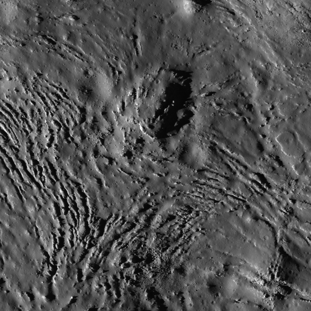
Fractures can be seen in profuse abundance on the Jackson crater melt pond surface. Illumination from west, a field of view roughly 700 meters across swept up at an incidence angle of 71.13° LROC Narrow Angle Camera (NAC) observation M118560367L, LRO orbit 2606, January 19, 2010; resolution 0.84 meters from 52.97 kilometers altitude. View the full-size Featured Image HERE [NASA/GSFC /Arizona State University].
James Ashley
LROC News System

As molten rock cools, it shrinks and often cracks. In this case of impact melt ponded within the Jackson crater floor (22.18°N, 197.24°E), the cracking rate was so high that unfractured melt is almost more of an exception than a rule!

Radial and divergent patterns can be seen among the fracture sets that tell a story of the cooling history. The context image below shows a portion of their wider distribution.

As context for the January 18, 2012 LROC Featured Image (field of view near where the impact melt inundating the crater floor emerges from eastern wall slump; the white box) a long view north and up the steep northeastern wall, nearly to the rim, courtesy of the digital elevation model combined in Google Earth [NASA/USGS/ASU/JAXA/Google].
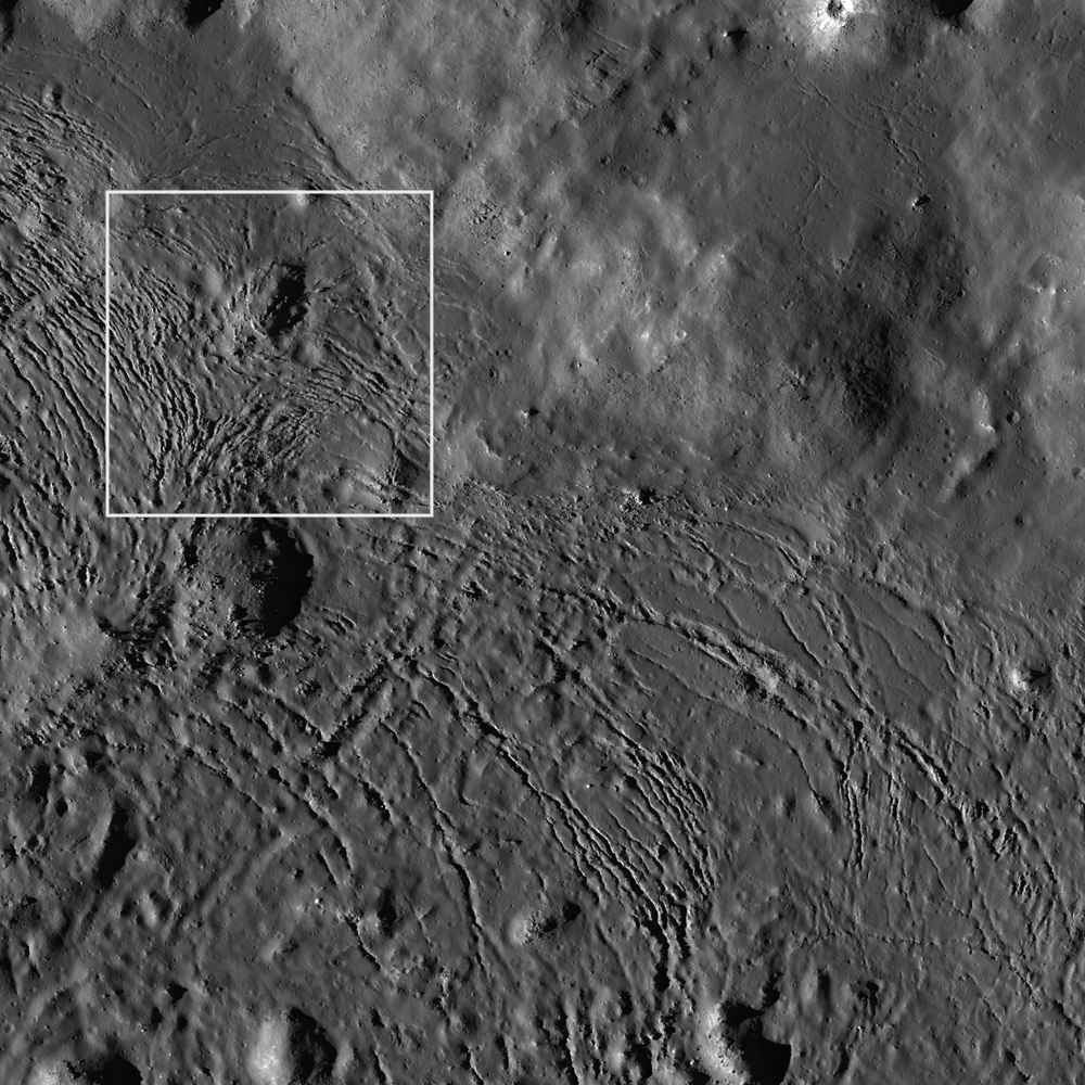
Overhead context for Featured Image, a field of view roughly 2.5 kilometers across from the wider LROC frame.View the full-size LROC context image HERE [NASA/GSFC/Arizona State University].
Solid objects in the melt, together with the 'shore' of the pond, appear to have influenced the way the cracks organized themselves as the melt cooled. Note how the fractures bend around or radiate from some of the positive relief features in the images above. These could be ejecta blocks or portions of the slumped crater walls in the melt that served to locally accelerate cooling. Their influence might thus be to 'seed' the stress field within the shrinking melt volume, helping some of the cracking to grow from these points, and ultimately resulting in the patterns we see today. Sagging along the shore can cause the cracking to parallel the shoreline. Any motion within the volume of melt, possibly influenced by late-stage additions of molten material, may also have contributed to the patterns observed here.

Further context, from 100 kilometers altitude, this square crop from a highly detailed HDTV still frame was captured by Japan's lunar orbiter SELENE-1 (Kaguya) in 2009 [JAXA/NHK/SELENE].
The extent and complexity of the melt pond features can be explored in the full NAC frame HERE. Additional examples of impact melt cracking include Polygonal fractures on Tycho ejecta deposits, fractured impact melt in Thales crater, and Moore F.

Ed Note: In a way opposite and contributing to the low optical visibility of the vast majority of similarly sized craters in the farside Highlands, Jackson is easier for the eye to see than most. Like Tycho on the nearside, there are a lot of craters of similar size and origin everywhere on the Moon. The difference is age. Like Tycho, the ray system of Jackson (and the materials its progenitor impact threw out) shows Jackson's "optical immaturity." To illustrate, below are two representations of the farside quadrant with the highest of the Highlands scoured by the Jackson impact, likely less than a half billion years ago.

Jackson stands out in this global montage of Clementine (1994) Ultra-Violet/Visible (UVVIS) wavelength photography designed to better map the Moon's albedo, more than a decade ago. Similar craters, basins and the Moon's highest elevations are nearly invisible [NASA/USGS/DOD].

A white arrow is needed to designate Jackson out from the pocked highlands and several otherwise invisible basins stand out with exceptional clarity in this view of nearly the same terrain as a representation of differences in elevation from the LROC Global Digital Terrain Model, developed using LROC Wide Angle Camera survey photography [NASA/GSFC/Arizona State University].

Friday, November 18, 2011

Slopes, Streaks and Flows

A granular debris flow on the wall of Stevinus A (downhill to the bottom and to the right, in the original full-size LROC Featured Image). A 7 meter boulder impedes the progress of the flow, which bifurcates and reconnects about 10 meters further downhill. LROC Narrow Angle Camera (NAC) observation M154893929R, LRO orbit 7960, March 16, 2011. Detail from LROC Featured Image Dry debris or liquid flow? by Lillian Ostrach, June 3, 2011 [NASA/GSFC/Arizona State University].
Paul D. Spudis
The Once & Future Moon
Smithsonian Air & Space

Although the Moon’s gravity is low, only about 0.165 of the Earth, rock and soil move down slope over time.  In geology, such processes are called mass wasting and is one of the principal sources of erosion on the Moon (the other being meteorite bombardment).  Mass wasting includes both gradual, infinitesimally slow soil creep on slopes and rapid, catastrophic mass movements, called landslides.  Long trains of rock debris can form scree slopes, loose fragments lying precariously at the critical angle beyond which they move, the angle of repose.  Because impact craters make steep walls and the larger ones bring up peaks in their centers, most mass wasting on the Moon is found in and around impact craters of all sizes.

Dark and light streaks on crater walls on the Moon. (click HERE to enlarge) [NASA/GSFC/Arizona State University].
As the number of high resolution images taken from the LRO mission continues to proliferate, several interesting and under-appreciated lunar surface phenomena are becoming more apparent.  Among the fresh craters of the Moon, we find light and dark steaks on the walls of the ubiquitous craters of the Moon.  Although it is not surprising that material might move or flow down steep slopes on the Moon, the appearance of these flows can be startlingly similar to those seen on other planets, particularly Mars, where such streaks have been cited as evidence for the presence of subsurface water.

The new narrow angle LRO camera can see objects on the surface smaller than one meter (typically, 50 cm per pixel resolution).  These new views have shown us a wide diversity of new features within impact craters and have given us a new appreciation for mass wasting.  Larger crater walls are slumped, with stair step-like wall terraces, concentrically arranged around the crater between rim and floor.  In detail, these terraces show ponds of dark material that seem to collect in low areas.  Most of this material looks like it was once molten but now congealed; it is probably solidified impact melt.  Flows of melt may cascade down and over the walls of fresh craters.

However, many “flows” of both dark and light material on the Moon seem to consist of loose fragments of rock debris lying on steep slopes.  These debris flows show a variety of morphologies, including simple flow shapes, cascades, ponding, and fan-like termini.  Sometimes the dark and light flows intermingle within a single crater while others show only one type.  These debris flows can usually be traced back to outcrops of bedrock in the upper portions of the crater wall.  As the bedrock erodes (usually by meteorite erosion and disaggregation due to the intense fracturing induced by the original impact that formed the crater), it sheds small fragments that train down slope, forming flow-like landforms.

Because crater walls are uneven, undulating surfaces, the rates of down slope movement can vary widely over small distances.  This sometimes results in multiple, overlapping flows of debris.  Factors that control the albedo (reflectivity) of the debris flows are not well understood.  It could be related to composition (for example, dark, iron-rich mare basalt vs. white, anorthositic highland rocks).  Another factor might be particle size; small pebble-sized rock flows could be bright as new, fresh surfaces are constantly exposed.  Flows that contain mixed soil might be darker than normal, as this soil could cover the fragments and reduce its average reflectivity.  But while all these factors may be of significance to one degree or another, the brightness of a streak is not particularly indicative of origin.

Dark streaks on crater walls, Mars. (click HERE to enlarge)

On Mars, many dark streaks are evident on crater walls and, as on the Moon, come in a wide variety of forms and occurrences.  Martian dark streaks have been variously interpreted as being caused by compositional and particle size differences, but the most popular idea is that the dark streaks are wet soil, i.e., they represent areas where liquid water is seeping out from the planet’s subsurface and moistening the surface.  One observation supporting this idea is an apparent correlation of some of the dark streaks with surface temperature, with warmer slopes showing more.  As liquid water is not stable on the martian surface, salt-rich brines (which would have much lower melting points than pure water) have been invoked as the possible liquid phase.

The dark streaks on the crater walls of the Moon call water-related interpretations of similar features on Mars into question.  The nature of down slope movement on Mars is likely to be controlled by even more diverse factors than the lunar case.  For example, large landslides partly cover the floor of the Valles Marineris, the large canyon system on Mars.  These landslides can extend tens of kilometers across the valley floor and the mass flow might have been lubricated by trapped atmospheric gas; this “cushioning” effect occurs within some landslides on the Earth.  Such a process would not occur on the Moon.  The diversity of geological processes on Mars suggests that explanations for dark wall streaks could encompass many more possibilities than simple wetting of the surface.

Although the existence of dark lunar streaks does not negate water-related interpretations of similar features on Mars, they do call attention to the need to keep alternative hypotheses in mind.  For many years (and with some success), planetary geologists have extrapolated landforms and processes (thought to be understood) on Earth, to similar appearing features on the planets.  In the case of the dark streaks, terrestrial water seepages in the desert can be darker than surrounding desiccated terrain.  A wide variety of evidence indicates that water is present in the subsurface on Mars but sometimes other effects such as rock composition or particle size are responsible for the streaks and alternatives to seepage should always be kept in mind.

Originally published November 17, 2011 at his Smithsonian Air & Space blog The Once and Future Moon, Dr. Spudis is a senior staff scientist at the Lunar and Planetary Institute. The opinions expressed are those of the author and are better informed than average.

Friday, April 22, 2011

LROC: Mare Undarum 'Action Shot'


Fresh ejecta blanket of an unnamed 1 kilometer-in-diameter crater (near 7.77°N, 64.87°E, ~45 kilometers east of Firmicus C). LROC Narrow Angle Camera (NAC) observation M154813223R, LRO orbit 7949, March 15, 2011; solar incidence angle 13°, field of view 750 meters across. View the full-sized LROC Featured Image HERE [NASA/GSFC/Arizona State University].

Susan Braden
LROC News System

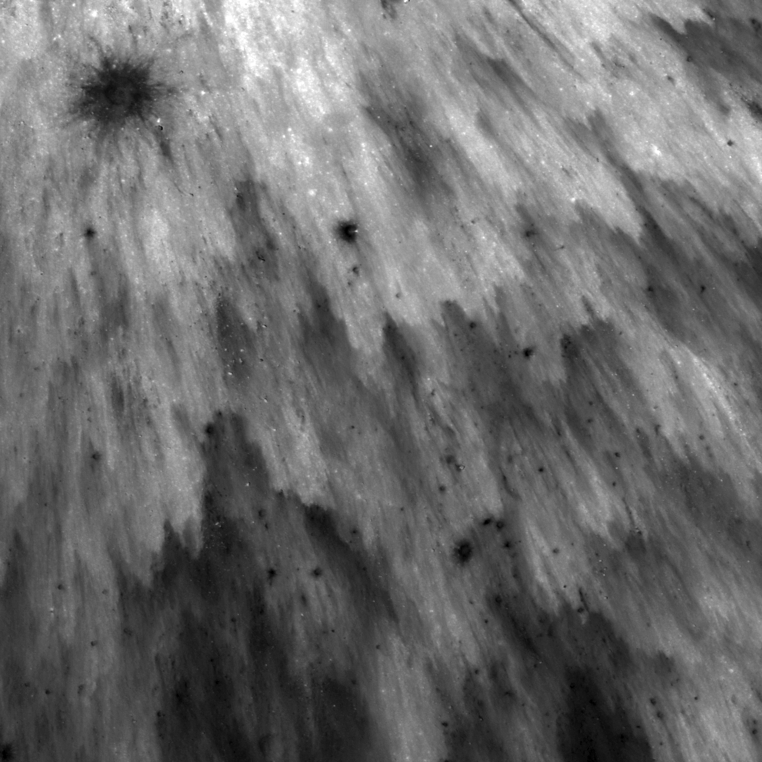
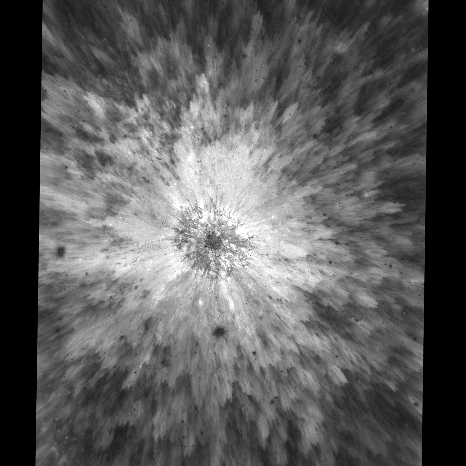
This small crater displays a beautiful ejecta pattern resembling a starburst. Looking at this image you can almost imagine the shower of ejecta falling to the ground.

The pattern formed out of high and low reflectance areas is due to the freshness of the ejecta. Notice in the second image that as you move away from the center of the crater, the overall reflectance of the ejecta gets lower (darker). This is because the ejecta is less continuous as you get further away from the crater.


Same NAC frame but with a larger view to show context. Notice the bouldery center of this fresh crater (zoom in HERE) and the two low albedo spots that represent secondary impacts. This image field of view is 2.2 km across. See the Full-Sized context image HERE [NASA/GSFC/Arizona State University].

There are two low reflectance (darker) spots in the ejecta, one just south of the main crater and another just west of it. If you look closely, these spots are actually small craters with their own ejecta, probably secondaries from the primary impact. They excavated material from beneath the ejecta blanket and that material has a lower albedo compared to the ejecta.

Explore the entire NAC Frame!

Related Images:
Splendors of Mare Smythii
Ejecta sweeps the surface
Delicate patterns in Giordano Bruno ejecta


40 by 74 kilometer-wide LROC Wide Angle Camera (WAC) monochrome mosaic field of view puts the bright crater and its fan of ejecta (west of direct center) in rough perspective. LROC WAC Mosaic Viewer [NASA/GSFC/Arizona State University].


Zooming out with the LROC WAC Mosaic Viewer, in turn, immediately puts the northwest quadrant of Mare Undarum (bottom) in even less granular perspective, and the fresh crater disappears amidst the Firmicus and Condorcet crater groups. The largest crater visible, northeast of center is 77 km Condorcet. Seeing just the southeastern edge of Mare Crisium at upper left, with its mountainous outer rings of mountains between itself and Undarum gives a fair indication of how far east this scene is, in line-of-sight perspective of the Moon's nearside as seen from Earth [NASA/GSFC/Arizona State University].