Showing posts with label Quickmap. Show all posts

Thursday, October 20, 2011

LROC: Lucian's Layers

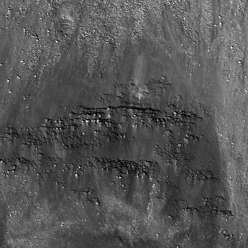
Layers of material are exposed forming small cliffs just within the south rim of Lucian, perhaps exposing the volcanic strategraphy and geologic history of Mare Tranquillitatis. LROC Narrow Angle Camera (NAC) observation M170321251R, LRO orbit 10234, September 10, 2011; field of view above is 290 meters. View the full resolution field of view in the LROC Featured Image HERE [NASA/GSFC/Arizona State University].
Drew Enns
LROC News System

Lucian crater, located in Mare Tranquillitatis at 14.3°N, 36.7° E, is a small (~7 km in diameter), relatively fresh crater. Because Lucian is still young, rock is freshly exposed in its wall, and the rocks are layered! But how do these layers relate to Mare Tranquillitatis? Scientists think that the maria were formed as the product of large scale flood volcanism.

Billions of years ago large volumes of lava were erupted from fissures in the lunar crust to cover 17% of the Moon's surface. But this process occurred over a period of time with a very low viscosity lava. This model of mare formation predicts that the mare are made up of many distinct layers. Prior to LROC some scientists argued that the layers were thin, and some scientists argued that the layers were thick. LROC data shows Lucian and other craters have thin layers that are a few meters thick. LROC has again helped scientists understand more about the nature of the Moon!

Full width 2 km-wide view of the layering under the surface of the Sea of Tranquility exposed by the explosive impact that formed Lucian crater probably late in the Eratosthenian era (1.1 - 3.1 billion years ago). The flat floor of the crater formed from pooled impact melt is just out of view above, though it is visible in the full NAC frame HERE, and in the Wide Angle Camera (WAC) view immediately below [NASA/GSFC/Arizona State University].

The layering inside the south rim of Lucian, steep slopes and floor of Lucian are visible in a late afternoon local illuminate here in the context of, from north to south, a roughly 36 km long field of view centered on the crater in north central Tranquillitatis: LROC WAC observation (643 nm) M119612004, LRO orbit 2761, January 31, 2010; resolution 61.7 meters per pixel, phase angle 57.81° from 43.76 kilometers [NASA/GSFC/Arizona State University].
A 132 kilometer wide slice of north central Mare Tranquillitatis when the Sun was less than 10 degrees above the east horizon allows more subtle variations in elevation to stand out in long shadows, and with it the variety of ancient features on one the Moon's oldest lunar mare fills. From a monochrome (604 nm) mosaic of LROC WAC observations gathered in sequential orbital passes (orbits 2237 through 2241) December 21, 2009. Highly reduced crop from an original resolution of about 63 meters, at a 57.8° phase angle, from 43.1 kilometers [NASA/GSFC/Arizona State University].
A quick view from the new and improved LROC QuickMap centered on Lucian composed of a base LROC WAC mosaic of northeast Mare Tranquillitatis with the WAC digital terrain model (DTM) overlay (500 meter resolution) at its default opacity of 30 percent [NASA/GSFC/Arizona State University].

How many layers can you count in the full NAC frame?

Related Posts:
Layers near Apollo 15 landing site
Layering in Messier A
Sublunarean void!

Monday, October 17, 2011

LROC Quickmap improvements dazzle

Roof top of the Moon (10,786 meters (35,387 feet) above global mean elevation), as determined by LRO investigators a year ago, is high on the lopsided eastern rim of Engel'gardt crater (5.7°N, 159.0°E), in the farside highlands; 44 km-wide and seen here immediately left of center in a field of view roughly 325 km wide and includes the northern Korolev basin (below). All these features are difficult to spot in cameras, not least of the reasons being in an area criss-crossed with superimposed bright rays. After this past weekend, however LROC premiered an overlay with a variable opacity showing their Global Wide Angle Camera (WAC) digital terrain model (DTM) in false color (here seen at the default 30% over the hybrid LROC NAC and WAC Global mosaic) is now an integral part of the ACT-REACT LROC Quickmap feature on their popular website, improving the map's usefulness when searching through LROC's vast data contribution to the Planetary Data System immeasurably [NASA/GSFC/Arizona State University].
An hour "playing" with the 'new and improved' LROC Quickmap enabled us to assemble this exploration of the tenuous connection between the Marius Hills and the Reiner Gamma albedo feature (with it's attendant crustal magnetic anomaly), both familiar features in Oceanus Procellarum. It's a place to begin digging deeper into the three dimensions of data from LROC already available to the public, especially with the new addition of the LROC DTM. Is Reiner Gamma's long swirl and it's intense local magnetism a result of a sub-surface flash flood of volcanic material? With the new LROC DTM overlay, it's much easier to demonstrate those features with little to no corresponding topographic expression and others nearly invisible except at very high sun angles [NASA/GSFC/Arizona State University].
Not very far from the Moon's highest point is what appears to be it's lowest, within the South Pole-Aitken basin, at the bottom of the large crater on the southern floor of Antoniadi (or, near 70.38°S, 187.2°E, over 9,000 meters below global mean elevation). This mix of LROC WAC imagery overlaid with the false-color WAC DTM adds more than just a feeling of depth of field. Most camera views of the floor of Antoniadi, and mare-filled features everywhere else on the Moon, the surface looks misleadingly flat. Even at 500 meter per pixel resolution, the wide deep flat floor of Antoniadi shows an uneven, almost "dune-like" roughness, lost in surveys based on albedo alone [NASA/GSFC/Arizona State University].
Another instant study increases the opacity of the LROC WAC DTM overlay from the base WAC optical mosaic of a nearside portion of the lunar south pole environs, offering an informative look at one of the Moon's last terra incognitas [NASA/GSFC/Arizona State University].
Related Post: LROC Quickmap

Saturday, April 16, 2011

LROC Quick Map

Still a beta version, the LROC Team is asking for your comments, suggestions and feedback on the Lunar Reconnaissance Orbiter Camera LROC :: ACT-REACT Quick Map.


Interior of largest crater within Antoniadi, LROC Narrow Angle Camera observation accessed through Equidistant Cylindrical projection of the LROC Quick-Map; resolution 2 meters per meter, corrected for foreshortening.


Likely the same NAC image of crater interior, very near or at the Moon's lowest elevation (over 9 kilometers below global mean) using the LROC Quick-Map southern Polar orthographic projection; resolution 1 meter per pixel.

Joel Raupe
Lunar Pioneer, LLP

Among the many places on the Moon we're patiently waiting to see through the unprecedented array on-board LRO, including a high-resolution LROC Narrow Angle Camera (NAC) glance into the depths of the crater within Antoniadi now confidently believed to be the lowest point on the Moon (very near 70.38°S, 187.2°E), over 9,000 meters below global mean elevation.

In of itself we've never expected to see anything unremarkable at that location, and there are other sites we're hoping to see that are still not in the admittedly enormous amount of LROC data already cataloged and available online.

LROC principal investigator Mark Robinson and his team at Arizona State University has, however, recently given the world's planetary science enthusiasts another new tool.

Every three months, with the publishing of another the newest big volume of LROC photographs to the Planetary Data System, we a handful of sites, a few of them already well-surveyed, and many not given the attention we anticipate, to see what's new.

That job may become much easier with the Quick Map, which, like the Lunar Orbiter and Clementine imagery available through Map-A-Planet interface maintained by the Astrogeology section of the United States Geologic Survey (USGS), begins with a equidistant cylindrical map of the Moon. Clicking your way toward a feature, and seeing many NAC observation frames layered over the LROC WAC monochrome mosaic pulls the user in from far above the Moon to full resolution.

After the release of LRO's Lunar Orbital Laser Altimeter (LOLA) Featured Image of Antoniadi Crater, after already using the nearly-as-new LROC Global WAC Viewer to get a closer look at the obscure but still very discernible outlines of Mare Australe, we used that same Viewer also to examine close-up Antoniadi through the LROC WAC Mosaic Viewer, hoping to compare the detail with what had, not long ago, also been photographed by Japan's Kaguya, using that vehicle's instruments.

We weren't disappointed at all, and yet the really deep spot in Antoniadi is now reliably measured at the bottom of the unnamed largest crater (diameter 11.2 km) within Antoniadi we've long informally been referring to as "Antoniadi A."


Antoniadi - seen through the High-Definition Television camera on-board Japan's SELENE-1 orbiter "Kaguya" in 2007. The informally-named 11 kilometer-wide simple crater inside the southern interior is Antoniadi A, confirmed now as host of the deepest elevations on the lunar surface [JAXA/NHK/SELENE].

Unfortunately, the deepest parts of Antoniadi A's interior, usually stay in deep shade. Antoniadi is almost a southern circumpolar feature, where shadows are always long and enduring. It's a long way from any permanently shadowed region, which makes capturing its deep spots particularly difficult. LRO would have to be engaged in capturing "Targets of Opportunity" while flying over Antoniadi at local High Noon, and then, because of the low latitude, the north interior would still be in shadow.

Is this the bottom, or at least half the bottom interior of "Antoniadi A," the lowest place on the lunar surface? Other data seem to show, hardly unusual for lunar craters, that the very bottom of "Antoniadi A" is not evenly distributed. But it's certainly one of the lowest spots, if not "the lowest." Elephant Skin mottling in the distribution of dust that some think is indicative of "grades" as opposed to even elevation seems to come to a halt close to the ends of boulder trails.


Antoniadi in a monochrome image assembled from data collected using Kaguya's Terrain Camera. See the image at its original resolution, HERE [JAXA/SELENE].

The only improvement in this phenomenal Quick Map one might ask for, at this point, is a non-obtrusive lable naming the NAC observation, making it possible to cross-reference the particulars of the meets and bounds of the observation's fundamentals. But, no matter.

This new tool may not give you access to the entire catalog yet, but we're definitely not complaining. No one's gotten this close to the lunar surface since Cernan & Schmitt in 1972.

The first image was collected from the ACT-REACT Quick Map Equidistant Cylindrical projection, and is slightly corrected for the foreshortening; the second from the Orthographic Map of the South Pole region also available through what should be an "award-winning" new feature made available by the conscientious LROC team.

Saturday, March 19, 2011

Quickmap of a real "Super Moon"


The beginnings of public access to the developing "Quickmap" service, linking LROC Narrow and Wide Angle Camera photography is astounding and immediately useful. It was possible to identify excellent candidates for artifacts not yet publicized, like the impact crater of the Apollo 17 lunar module ascent stage "Challenger" and possibly Luna 9, for example [NASA/GSFC/Arizona State University].

Mark Robinson
Principal Investigator
Lunar Reconnaissance Orbiter Camera
Arizona State University


Try out the new LROC browse interface - Quickmap.

Its a lot of fun! Start at reduced WAC resolution and end up on the surface at full NAC resolution. Quickmap is brand new (and not 100% refined). But, it's ready for testing!

Give it a try and watch it improve over the next several months.

We hope you like it!


It was immediately possible to focus in on regular NAC observations of Tranquility Base and the rich context of its vicinity in southwestern Mare Tranquillitatis, picking the high glint off the Apollo 11 lunar module descent stage at a resolution of only 64 meters per pixel [NASA/GSFC/Arizona State University].