Showing posts with label Chandrayaan-1. Show all posts

Wednesday, February 26, 2014

You too, Yutu?

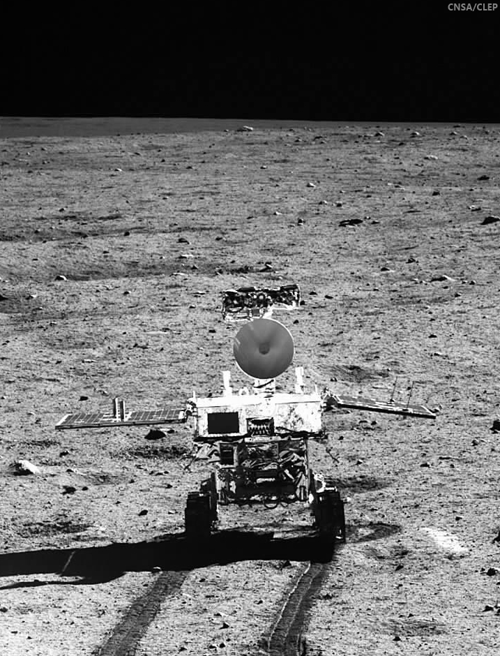
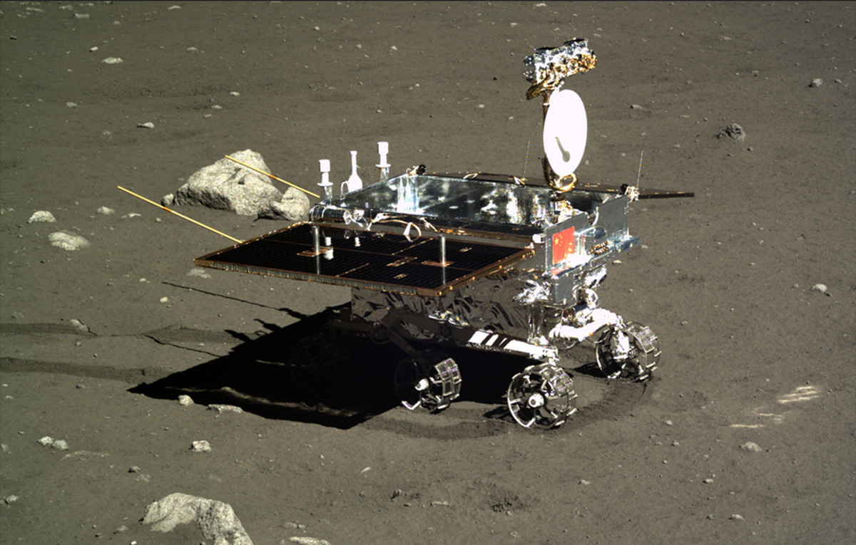
Jade Rabbit, "Yutu," the first lunar rover since Lunokhod-2 explored Le Monnier crater for the first half of 1973, in profile, as seen from the Chang'e-3 Panoramic Camera soon after deployment and its first tantalizingly brief trip across a few square meters of Mare Imbrium. The twin dipole antenna extending behind the vehicle are its ground-penetrating array [CAS/CNSA/CLEP].
Paul Spudis
The Once and Future Moon
Smithsonian Air & Space

Another lunar day has come and gone on the barren plains of Mare Imbrium.  How fares its most famous terrestrial inhabitant, the Chang’E 3 spacecraft and Jade Rabbit, the little Yutu rover?  The fact is, we really don’t know and those that presumably do aren’t talking about it much.

The Yutu rover of the Chang’E 3 mission has experienced some “mechanic control abnormality due to the complicated lunar surface,” is how the Chinese phrased the situation.  Details on the nature of the problem are impossible to come by, but one clear result is that the Yutu cannot move.  It apparently spent the last lunar day (which lasted from about 10 February until last weekend) sitting in one place.  For some scientific investigations, that is not necessarily a problem, but for Yutu’s primary scientific mission, it is fatal.

The goal of placing a rover on the Moon is to explore and examine multiple sites distant from each other.  Additionally, the traverse between stations enables unique experiments, such as profiling the surface – the principal objective of the ground-penetrating radar on China’s rover.  As the vehicle moves across the lunar surface, it emits radio waves of varying frequency into the surface.

Reflections from subsurface layers or boundaries are then received by the rover’s antenna, thereby allowing scientists to infer subsurface structure.  To get a subsurface profile, these measurements must be taken while the rover is moving.  Thus, an immobile rover makes this experiment impossible.

The rover’s other instruments operate during a stationary period.  However, once a chemical measurement has been made or an image taken, there is little value in continually repeating it.

If the Yutu rover is immobile, its scientific mission is effectively over.

News reports have stopped giving us data and information from the Chang’E 3 lander (which has a camera and an ultraviolet telescope) but assuming it is still operating, it may continue making observations.  The lander spacecraft made a panorama of the landing site, so that objective was completed.  Presumably, if the UV telescope is still operating, it can continue observing the sky but these observations are not significant to lunar science.

Three LROC NAC views of the Chang'e-3 landing site in north Mare Imbrium (44.1214°N, 340.4884°E, -2630 m elev.), before landing, after deploying the Yutu rover (south of the lander) and after Yutu was moved just to the southeast of the lander, where it apparently failed (and remains) reportedly following a ground-operations error during preparations ahead a long lunar night [NASA/GSFC/Arizona State University].
Thus, from the perspective of lunar science, it appears that the Chang’E 3’s Moon mission is over.

So, how did Yutu do as a lunar explorer?  For now, we really don’t know.  Aside from a few color images and a chemical spectra that was released to the press, little scientific data has been revealed (a Google translate version of a Chinese web page describing the Chang’E 3 science to date can be read HERE).  The data we have seen mostly show that the instruments were functioning.  We do not know how many measurements were made, what they have told us, or the geological setting of the chemical analyses.

The Chang’E 3 lander set down very near the rim of a crater 450 meters in diameter, a feature whose walls are littered with angular blocks clearly derived from the local bedrock. The fact that the Yutu did not make an immediate beeline over to those blocks for a detailed examination and chemical analysis tells me one of two things: either those planning the rover’s exploration traverse are not geologists or they didn’t get to it before the rover stopped working.

Yutu has led a famous existence in cyberspace, with numerous “tweets” to the world.  A public eager to anthropomorphize machines has responded in kind, including offering several admonitions to the rover to “pay attention to his wake-up calls.”  All this rhetorical cuteness hides the fact that China has been less than forthcoming about this mission, as they are about all of their space missions.  We hear only what they want us to hear.  Successes (of which they have had many) are widely trumpeted with blasts of publicity, while difficulties and failures are buried in silence.  It’s true that a space program run by the military (in the case of China, the People’s Liberation Army) will tend toward such an ethic.  But the WALL·E-like image promoted by China early in the mission is not the image conveyed by their current posture with the world press.

I find the Chinese attitude both interesting and dismaying.  It is similar to one that I experienced with Indian Space Research Organization (ISRO) during the Chandrayaan-1 lunar orbiter mission.  When the Chandrayaan spacecraft was running into difficulties after a few months in lunar orbit, the organizational instinct was to deny any problems and be less than forthcoming with the press about the status of the spacecraft.

Spaceflight is inherently difficult and things break all the time.  It is beyond ridiculous to cover up a problem by pretending that it doesn’t exist.  Similar behavior patterns characterized the early Soviet space program, in which we never heard about mission failures, but successes were given widespread publicity.  It seems that to date, China is adhering to that model.

There has been much in the media about the non-welcoming posture of some towards engagement and possible cooperation with China in space – admonishing Congress and NASA to be open to cooperating with China on future space missions.  There may come a time when this is possible but for now, it seems that reality is far away.

Dr. Paul D. Spudis is a senior staff scientist at the Lunar and Planetary Institute in Houston. This column was originally published by Smithsonian Air & Space, and his website can be found at www.spudislunarresources.com. The opinions he expressed here are his own, and these are better informed than most.

Related Posts:
It's not bragging if you do it (December 9, 2013)
China's Long March to the Moon (January 14, 2012)

Friday, January 31, 2014

ESA on Yutu, as controllers wait for sunrise, February 9

Yutu
Song of Yutu. China News reported panorama photographs of the Chang'e-3 lander captured by Yutu and corresponding images of the Jade Rabbit rover from the lander, prior to the end of their second 330 hour-long lunar day, January 25, were the final such complimentary photographs of the mission [CAS/CNSA/CLEP].
Professor Bernard H. Foing
Bernard Foing
Executive Director
International Lunar Exploration Working Group (ILEWG).

ESA SMART-1 Project scientist

The Chang'e3 lander and Yutu rover achieved impressive results in their first lunar day on the surface, where temperatures are over 90°C (194°F) at midday. After their first lunar night, which is extreme, with temperatures dropping to -180°C (-292°F), they spectacularly woke up and resumed operations after January 12.

This was already an achievement considering the very difficult thermal conditions and surface environment on the Moon. Already with our SMART-1 (2003) spacecraft orbiting the Moon we had to solve thermal problems, but it is much more difficult for a rover on the surface.

Unofficial information mentions a mechanical problem during the withdrawal of a solar panel on rover Yutu prior to sleep on January 25 for the second night. This could affect the electronic box and a few instruments on the rover mast.

Operations of the Chang'e-3 lander instruments would not be affected.

1. Is it likely that lunar dust caused a mechanical failure, meaning the rover could not hibernate?  It is not established that dust is the culprit at this stage. The high thermal extremes from day to night (from 90° to –180°C, or 194° to -292°F) can also certainly put a huge stress and fatigue on mechanical systems.

2. What can be done to protect future rovers from lunar dust?  Already measures are being taken by rover designers to avoid dust entering sensitive mechanical gear or depositing on optical surfaces. However lunar dust can be electrostatically charged and can stick on sensitive parts.

3. Is Yutu no longer operational, or could it be fixed?  Our Chang’e 3 and Yutu colleagues can be praised for what they have achieved so far. I am sure that they are not going to give up. They are analyzing, in depth, the problem and are working hard to assess safe recovery strategies.

4. How will this failure restrict the remaining mission?  The lander went nominally to sleep (January 25). The Yutu rover sent an emotional farewell message before hibernating. For the Yutu rover we have to hope and wait for the next lunar morning (around February 9) to assess the situation. Best wishes from all of us to the Yutu lunar Jade Rabbit.

We wish the teams and Change3 Yutu good luck and success for further operations. Lunar exploration is difficult, but these technical challenges bring progress for future lunar and planetary missions and even for applications in space and on Earth.

Related Posts:
Problem with solar-powered Yutu rover before nightfall (January 25, 2014)
Chang'e begins long-term science mission (January 18, 2014)
Preliminary Science Results from Chang'e-3 (January 16, 2014)
Chang'e-3 and Yutu survive first lunar night (January 14, 2014)
Chang'e-3 APXS delivers its first surface analysis (January 1, 2014)
Chang'e-3 lander and Yutu rover from LRO (December 31, 2013)
6 of 8 Chang'e-3 science instruments now active (December 18, 2013)
LRO: Finding Chang'e-3 (December 15, 2013)
China's Jade Rabbit, it's time in the Sun (December 15, 2013)
Chang'e-3 Landing Site in Mare Imbrium (December 15, 2013)
Jade Rabbit successfully deployed to the lunar surface (December 14, 2013)
It's not bragging if you do it (December 9, 2013)
"Lunar Aspirations" - Beijing Review (December 9, 2013)
Chang'e-3 safely inserted into lunar orbit (December 6, 2013)
CCTV: Chang'e-3, launch past TLO to Earthview (December 2, 2013)
Chang'e-3 launched from Xichang (December 1, 2013)
Chang'e-3 launch window opens 1 December 1730 UT (November 29, 2013)
Helping China to the Moon, ESA (November 29, 2013)
'Government Penalty' removed from Google Lunar XPRIZE terms (November 7, 2013)
Chang'e-3 and LADEE: The Role of Serendipity (October 31, 2013)
Outstanding animation celebrates China's Chang'e-3 (October 29, 2013)
LROC updates image tally of human artifacts on the Moon (September 25, 2013)
Chang'e-3: China's rover mission (May 4, 2013)
China's grand plan for lunar exploration (October 11, 2012)
ILOA to study deep space from Chang'e-3 (September 11, 2012)
China's Long March to the Moon (January 14, 2012)
China plans lunar research base (May 11, 2011)
PRC continues methodical program (March 8, 2011)
Chang'e-2 arrives in mission orbit (October 9, 2010)
Dispatch from Chang'e-2: Sinus Iridum (October 4, 2010)
Chang'e-2 takes direct approach (October 1, 2010)
Chang'e-2 sets stage for future lunar missions (September 3, 2010)
Chang'e-1 research reported published (July 22, 2010)
Chandrayaan-1 goes silent (August 29, 2009)

Tuesday, January 21, 2014

Clementine - The Legacy, Twenty Years On

Engineering model of the Clementine spacecraft in the Lunar Exploration Vehicles exhibit at the National Air and Space Museum. Interstage and solid rocket motor (bottom half) was discarded before insertion into lunar orbit.
Paul D. Spudis
Smithsonian Air & Space

The first spacecraft to globally map the Moon left lunar orbit on May 3, 1994.  Clementine, a joint Department of Defense-NASA mission, had systematically mapped the Moon’s surface over 71 days, collecting almost 2 million images.  For the first time, scientists could put results of the Apollo lunar sample studies into a regional, and ultimately, a global context.  Clementine collected special data products, including broadband thermal, high resolution and star tracker images for a variety of special studies.  But in addition to this new knowledge of lunar processes and history, the mission led a wave of renewed interest in the processes and history of the Moon, which in turn, spurred a commitment to return there with both machines and people.  We peeked into the Moon’s cold, dark areas near the poles and stood on the edge of a revolution in lunar science.

Prior to Clementine, good topographic maps only existed for areas under the ground tracks of the orbital Apollo spacecraft.  From Clementine’s laser ranging data, we obtained our first global topographic map of the Moon.  It revealed the vast extent and superb preservation state of the South Pole-Aitken (SPA) basin and confirmed many large-scale features mapped or inferred from only a few clues provided by isolated landforms.  Correlated with gravity information derived from radio tracking, we produced a map of crustal thickness, thereby showing that the crust thins under the floors of the largest impact basins.

Two cameras (with eleven filters) covered the spectral range of 415 to 1900 nm, where absorption bands of the major lunar rock-forming minerals (plagioclase, pyroxene and olivine) are found.  Varying proportions of these minerals make up the suite of lunar rocks.  Global color maps made from these spectral images show the distribution of rock types on the Moon.  The uppermost lunar crust is a mixed zone, where composition varies widely with location.  Below this zone is a layer of nearly pure anorthosite, a rock type made up solely of plagioclase feldspar (formed during the global melting event that created the crust).  Craters and large basins act as natural “drill holes” in the crust, exposing deeper levels of the Moon.  The deepest parts of the interior (and possibly the upper mantle) are exposed at the surface within the floor of the enormous SPA basin on the far side of the Moon.

Topographic map of the Moon made from Clementine laser altimetry in mid-latitudes and stereo images near the poles. Large depression in southern far side is the South Pole-Aitken basin.
Clementine showed us the nature and extent of the poles of the Moon, including peaks of near permanent sun-illumination and crater interiors in permanent darkness.  From his first look at the poles, Gene Shoemaker (Leader of the Clementine Science Team) got an inkling that something interesting was going on there.  Gene was convinced that water ice might be present, an idea about which I had always been skeptical.  At that time, no trace of hydration had ever been found in lunar minerals and the prevailing wisdom was that the Moon is now and always had been bone dry.  With Gene arguing to keep an open mind and Stu Nozette (Deputy Program Manager) devising a bistatic radio frequency (RF) experiment to use the spacecraft transmitter to “peek” into the dark areas of the poles, we moved ahead on planning the observations.

To my astonishment (and delight), a pass over the south pole of the Moon showed evidence for enhanced circular polarization ratio (CPR) – a possible indicator of the presence of ice.  A control orbit over a nearby sunlit area showed no such evidence.  However, CPR is not a unique determinant for ice, as rocky, rough surfaces and ice deposits both show high CPR.  It took a couple of years to reduce and fully understand the data, but collection of the bistatic collection was successful.  In part, our ice interpretation was supported by the discovery of water ice at the poles of Mercury (a planet very similar to the Moon).  We published our results in Science magazine in December 1996, setting off a media frenzy and a decade of scientific argument and counter-argument about the interpretation of radar data for the lunar poles (an argument that continues to this day, despite subsequent confirmation of lunar polar water from several other techniques).

Along with Clementine’s success came a growing interest in lunar resources and a new appreciation for the complexity of the Moon.  This interest led to the selection of Lunar Prospector (LP) as the first PI-led mission of NASA’s new, low-cost Discovery series of planetary probes.  LP flew to the Moon in 1998 and carried instruments complementary to the data produced by Clementine, including a gamma-ray spectrometer to map global elemental composition, magnetic and gravity measurements, and a neutron spectrometer to map the distribution of hydrogen.  LP found enhanced concentrations of hydrogen at both poles, again suggesting that water ice was probably present.  The debate on the abundance and physical nature of the water ice continued, with estimates ranging from a simple enrichment of solar wind implanted hydrogen in polar soils, to substantial quantities of water ice trapped in the dark, cold regions of the poles.

Buttressed by this new information, the Moon became an attractive destination for robotic and human missions.  With direct evidence for significant amounts of hydrogen (regardless of form) on the surface, there now was a known resource that would support long-term human presence.  This hydrogen discovery was complemented by the identification in Clementine images of several areas near the pole that remain sunlit for substantial fractions of the year – not quite the “peaks of eternal light” first proposed by French astronomer Camille Flammarion in 1879 but something very close to it.  The availability of material and energy resources  – the two biggest necessities for permanent human presence on the Moon – was confirmed in one fell swoop.  Combined, the results of Clementine and LP finally gave scientists the Lunar Polar Orbiter mission we had long sought.  These two missions certified the possibility of using lunar resources to provision ourselves in space, permanently establishing the Moon as a valuable, enabling asset for human spaceflight.  Remaining was to verify and extend the radar results from Clementine and map the ice deposits of the poles.

The Clementine bistatic experiment led to the development of an RF transponder called Mini-SGLS (Space Ground Link System), which flew on the Air Force mission MightySat II in 2000.  This experiment miniaturized the RF systems necessary for a low mass, low power imaging radar.  With the 2008 inclusion of our Mini-SAR on India’s Chandryaan-1 lunar orbiter, we finally got the chance to build and fly such a system.  Chandrayaan-1 not only mapped the high CPR material at both poles, it also carried a spectrometer (the Moon Mineralogy Mapper, or M3) that discovered large amounts of adsorbed surface water (H2O) and hydroxyl (OH) at high latitudes.  Coupled with the measurement of exospheric water above the south pole by its Moon Impact Probe, Chandrayaan-1 significantly advanced our understanding of polar water, revealing it to be abundant and present in more varied forms on the Moon than had previously been imagined.

Mosaic of Clementine images of the south pole of the Moon. Dark regions contain water ice and small areas near pole are sunlit for significant fractions of the lunar day.
The ever increasing weight of evidence for the presence of significant amounts of water at the lunar poles led to the LCROSS experiment being “piggybacked” on NASA’s 2008 Lunar Reconnaissance Orbiter (LRO) mission.  LCROSS was a relatively inexpensive add-on, designed to observe the collision of the LRO launch vehicle’s Centaur upper stage with the lunar surface, looking for water in the ejecta plume of that impact.  Water in both vapor and solid form was observed, suggesting the presence of water ice in the floor of the crater Cabaeus (at concentration levels between 5 and 10 weight percent).  LRO orbits the Moon and collects data to this day.  Although much remains unknown about lunar polar water, we now know for certain that it exists; such knowledge has completely revised our thinking about the future use and habitation of the Moon.

The Clementine programmatic template has influenced spaceflight for the last 20 years.  The Europeans flew SMART-1 to the Moon in 2002, largely as a technology demonstration mission with goals very similar to those of Clementine.  NASA directed the Applied Physics Laboratory (APL) to fly Near-Earth Asteroid Rendezvous (NEAR) to the asteroid Eros in 1995 as a Discovery mission, attaining the asteroid exploration opportunity missed when control of the Clementine spacecraft was lost after leaving the Moon.  India’s Chandrayaan-1 was of a size and payload scope similar to Clementine.  The selection of LCROSS as a low-cost, fast-tracked, limited objectives mission further extended use of the Clementine paradigm.

The “Faster-Better-Cheaper” mission model, once panned by some in the spaceflight community, is now recognized as a preferred mode of operations, absent the emotional baggage of that name.  A limited objectives mission that flies is more desirable than a gold-plated one that sits forever on the drawing board.  While some missions do require significant levels of fiscal and technical resources to attain their objectives, an important lesson of Clementine is that for most scientific and exploration goals, “better” is the enemy of  “good enough.”  Space missions require smart, lean management; they should not be charge codes for feeding the beast of organizational overhead.  Clementine was lean and fast; perhaps we would have made fewer mistakes had the pace been a bit slower, but overall the mission gave us a vast, high-quality dataset, still extensively used to this day.  The Naval Research Laboratory transferred the Clementine engineering model to the Smithsonian in 2002.  The spacecraft hangs today in the Air and Space Museum, just above the Apollo Lunar Module.

It is probably not too much of an exaggeration to say that Clementine changed the direction of the American space program.  After the failure of SEI in 1990-1992, NASA was left with no long-term strategic direction.  For the first time in its history, NASA had no follow-on program to Shuttle-Station, despite attempts by Dan Goldin and others to secure approval for a human mission to Mars (then and now, a bridge too far – both technically and financially).  This programmatic stasis continued until 2003, when the tragic loss of Columbia led to a top-down review of U.S. space goals.  Because Clementine had documented its strategic value, the Moon once again became an attractive destination for future robotic and human missions.  The resulting Vision for Space Exploration (VSE) in 2004 made the Moon the centerpiece of a new American effort beyond low Earth orbit.  While Mars was vaguely discussed as an eventual (not ultimate) objective, the activities to be done on the Moon were specified in detail in the VSE, particularly with regard to the use of its material and energy resources to build a sustainable program.  Regrettably, various factors combined to subvert the Vision, thereby ending the strategic direction of America’s civil space program.

Clementine was a watershed, the hinge point that forever changed the nature of space policy debates.  A fundamentally different way forward is now possible in space – one of extensibility, sustainability and permanence.  Once an outlandish idea from science fiction, we have found that lunar resources can be used to create new capabilities in space, a welcome genie that cannot be put back in the bottle.  Americans need to ask why their national space program was diverted from such a sustainable path.  We cannot afford to remain behind while others plan and fly missions to understand and exploit the Moon’s resources.  Our path forward into the universe is clear.  In order to remain a world leader in space utilization and development – and a participant in and beneficiary of a new cislunar economy – the United States must again direct her sights and energies toward the Moon.

Note: Background history for the Clementine mission is described in a companion post at my Spudis Lunar Resources blog, HERE.

Originally published at his Smithsonian Air & Space blog The Once and Future Moon, Dr. Spudis is a senior staff scientist at the Lunar and Planetary Institute. The opinions expressed are those of the author but are better informed than average.

Tuesday, December 10, 2013

Strong hints of mixing seen in South Pole-Aitken M3 data

LROCNAC-bhabha_cpeak-1200
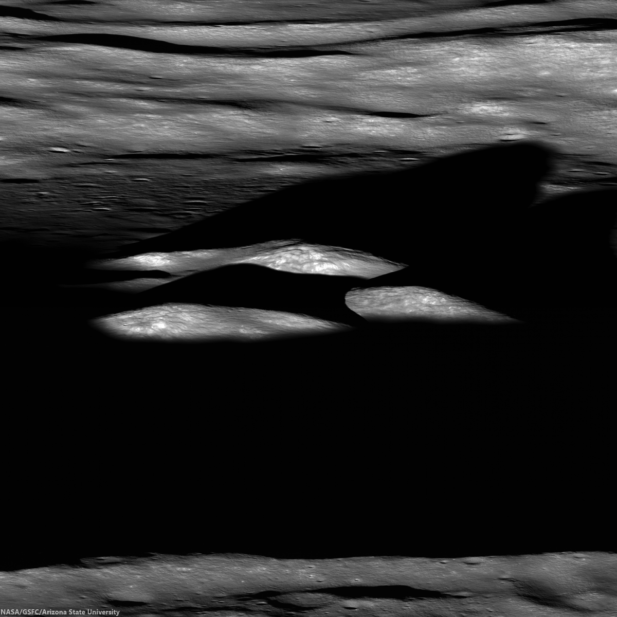
Last rays striking the central peaks of Bhabha crater, near the center of South Pole-Aitken basin, an oblique view from the west. LROC Featured Image, "Bhabha sinks into the shadows," July 21, 2010 [NASA/GSFC/Arizona State University].
PROVIDENCE, R.I. [Brown University] — Researchers from Brown University and the University of Hawaii have found some mineralogical surprises in the Moon’s largest impact crater.

Data from the Moon Mineralogy Mapper (M3) that flew aboard India’s Chandrayaan-1 lunar orbiter shows a diverse mineralogy in the subsurface of the giant South Pole Aitken basin. The differing mineral signatures could be reflective of the minerals dredged up at the time of the giant impact 4 billion years ago, the researchers say. If that’s true, then the South Pole Aitken (SPA) basin could hold important information about the Moon’s interior and the evolution of its crust and mantle.

The study, led by Brown graduate student Dan Moriarty, is published in online early view in the Journal of Geophysical Research: Planets.

At 2,500 kilometers across, the SPA is the largest impact basin on the Moon and perhaps the largest in the solar system. Impacts of this size turn tons of solid rock into molten slush. It has been assumed generally that the melting process would obliterate any distinct signatures of pre-existing mineralogical diversity through extensive mixing, but this latest research suggests that might not be the case.

LROCWACDTM-SPA-tour
South Pole-Aitken basin, with Bhabha and Leeuwenhoek craters noted, and more easily seen in the full resolution view, HERE [NASA/GSFC/SVS].
The study looked at smaller craters within the larger SPA basin made by impacts that happened millions of years after the giant impact that formed the basin. Those impacts uncovered material from deep within the basin, offering important clues about what lies beneath the surface. Specifically, the researchers looked at the central peaks of four craters within the basin. Central peaks form when material under the impact zone rebounds, forming an upraised rock formation in the middle of the crater. The tops of those peaks represent pristine material from below the impact zone.

Using Moon Mineralogy Mapper data, the researchers looked at the light reflected from each of the four central peaks. The spectra of reflected light give scientists clues about the makeup of the rocks. The spectra showed substantial differences in composition from peak to peak. Some crater peaks were richer in magnesium than others. One of the four craters, located toward the outer edge of the basin, contained several distinct mineral deposits within its own peak, possibly due to sampling a mixture of both upper and lower crust or mantle materials.

The varying mineralogy in these central peaks suggests that the SPA subsurface is much more diverse than previously thought.

“Previous studies have suggested that all the central peaks look very similar, and that was taken as evidence that everything’s the same across the basin,” Moriarty said. “We looked in a little more detail and found significant compositional differences between these central peaks. The Moon Mineralogy Mapper has very high spatial and spectral resolution. We haven’t really been able to look at the Moon in this kind of detail before.”

The next step is figuring out where that diversity comes from.

M1124763264LR-NSJ-0603-580x1200-61p-2800x5793
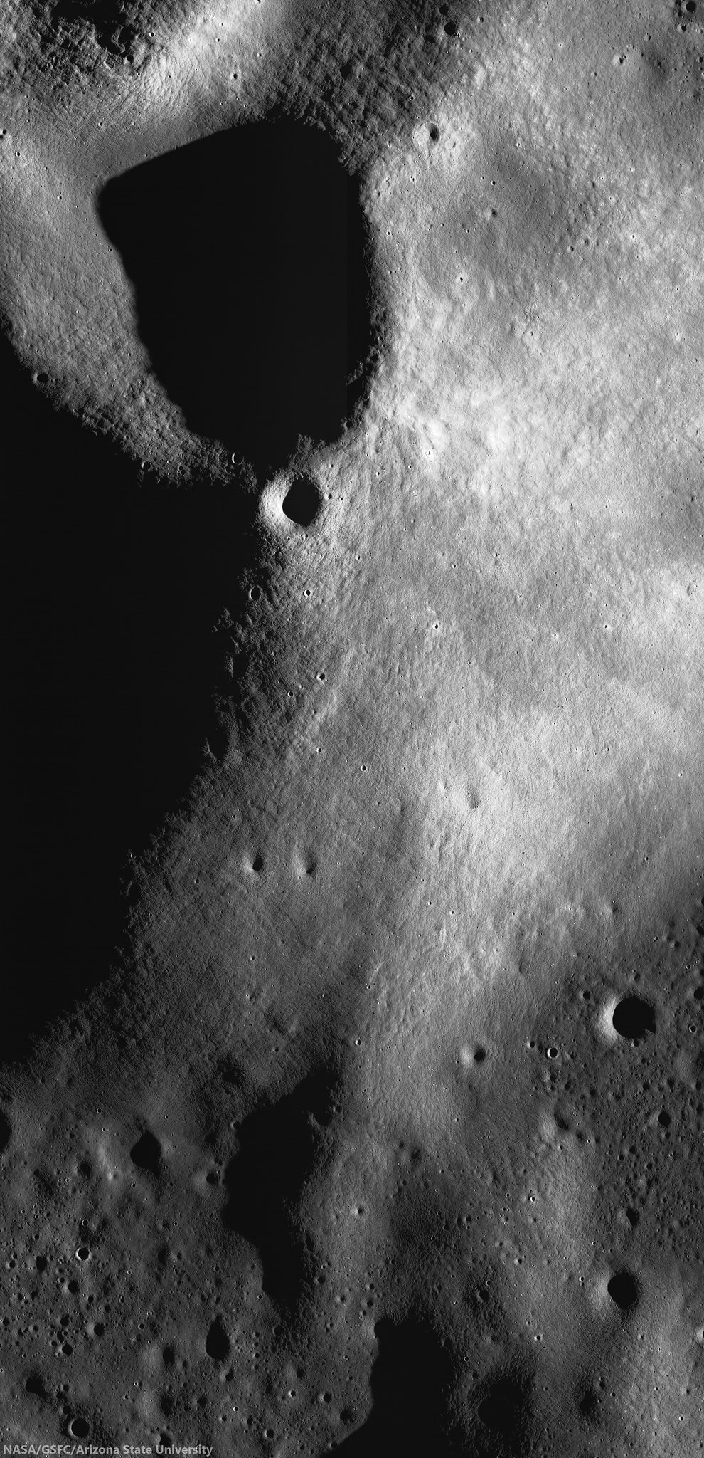
High-resolution view of small crater superpositioned on the south central peaks of Leeuwenhoek crater. Chandrayaan-1 Moon Mineralogical Mapper (3M) data studied by researchers at Brown University demonstrates evidence that lunar mantel was upthrust and exposed when Leeuwenhoek formed, perhaps close to the original transitory crater rim of 4.2 billion year old South Pole-Aitken basin. LROC NAC mosaic M1124763264RL, LRO orbit 17925, June 1, 2013; sunrise angle of incidence 83° resolution roughly 1.6 meters per pixel from 77.84 km [NASA/GSFC/Arizona State University].
It’s possible that the distinct minerals formed as the molten rock from the SPA impact cooled. Recent research from Brown and elsewhere suggests that such mineral formation in impact melt is possible. However, it’s also possible that the mineral differences reflect differences in rock types that were there before the giant SPA impact. Moriarty is currently undertaking a much larger survey of SPA craters in the hope of identifying the source of the diversity. If indeed the diversity reflects pre-existing material, the SPA could hold important clues about the composition of the Moon’s lower crust and mantle.

“If you do the impact scaling from models, [the SPA impact] should have excavated into the mantle,” Moriarty said. “We think the upper mantle is rich in a mineral called olivine, but we don’t see much olivine in the basin. That’s one of the big mysteries about the South Pole Aitken basin. So one of the things we’re trying to figure out is how deep did the impact really excavate. If it melted and excavated any material from the mantle, why aren’t we seeing it?”

If the impact did excavate mantle material, and it doesn’t contain olivine, that would have substantial implications for models of how the Moon was formed, Moriarty said.

8-SPA-meltpool-787
Two centers? The center of South Pole-Aitken basin is not yet agreed on, partly because it's oval shape is evidence of an oblique impact and also because of its immense age, with much of its original surface now erased. Subsequent impacts, however, has exposed deeper, perhaps the deepest and oldest materials, from the Moon's original formation [NASA/GSFC/Arizona State University].
Much more research is needed to begin to answer those larger questions. But this initial study helps raise the possibility that some of the original mantle mineralogy, if excavated, may be preserved in the Moon’s largest impact basin.

Carle Pieters, professor of geological sciences at Brown, and Peter Isaacson from the University of Hawaii were also authors on the paper. The work was supported by NASA’s Lunar Advanced Science and Exploration Research (LASER) program and the NASA Lunar Science Institute (NLSI).

Wednesday, October 16, 2013

Measuring almost nothing, looking for the almost invisible

hdtv_010_4_l-580x1080
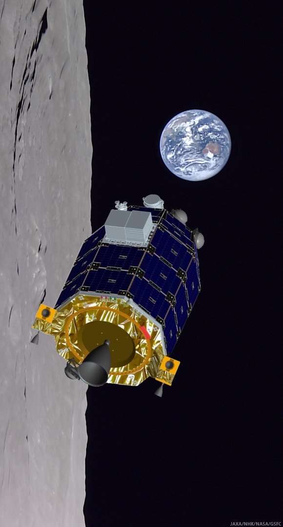
NASA's LADEE spacecraft entered it's 250 km Commissioning phase orbit October 12 [NASA/JAXA].
Paul D. Spudis
The Once and Future Moon
Smithsonian Air & Space

Launched last month from the Wallops Island site, LADEE (for Lunar Atmosphere and Dust Environment Explorer) will spend the next few months orbiting the Moon.  This small spacecraft will attempt to characterize and measure the lunar “atmosphere,” while also looking for dust that might be electrostatically levitated above the surface or thrown into ballistic flight by impacts.

Wait a minute.  Did I say “atmosphere?”  Isn’t the Moon renowned for its lack of an atmosphere?  Indeed it is.  In fact, the 10-12 torr surface pressure of the Moon is a better vacuum than we can achieve with even the most advanced equipment in Earth laboratories.  (For comparison, sea level pressure on the Earth is about 760 torr, making the lunar surface pressure over one hundred trillion times less dense.)  A better term for the tenuous gas near the Moon is “exosphere,” meaning free flying gas molecules that may or may not be gravitationally bound to the Moon.  In such an “atmosphere,” there may be only a few thousand molecules in a cubic centimeter of space. This is very tenuous indeed.
  
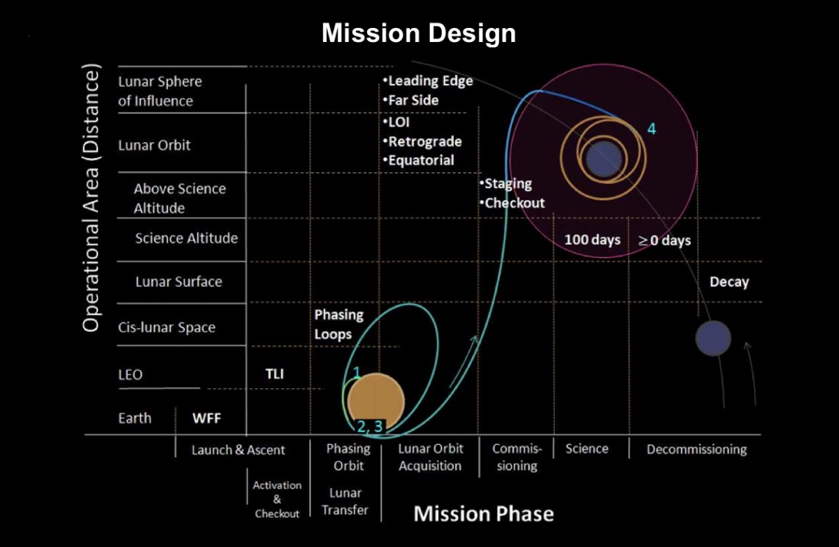
After the Commissioning phase of its mission is complete, the spacecraft's current 250 km circular orbit will be reduced further down to within 50 km to begin its 100 day Science Mission [NASA/GSFC].
LADEE is designed to investigate from where these atoms and molecules come.  Presently, we think the lunar exosphere consists mostly of helium, sodium and perhaps argon atoms, each coming from a completely different source.  Helium likely comes from the Sun, as the solar wind continually “breathes” onto the surface of the Moon.  Some atoms stick to surface dust grains but many simply bounce off, randomly moving in the space above the lunar surface.  Easy to detect, lunar sodium has been observed from Earth-based telescopes.  It most likely comes from rocks vaporized by the continual rain of micrometeorites.  At least some fraction of this vaporous sodium must hang around the surface, unable to escape the Moon.  Argon might have a solar wind origin, but at least some of it comes from the natural decay of radioactive potassium in the lunar interior (potassium-40 (40K) decays to argon-40 (40Ar) with a half-life of a bit more than one billion years).  Gases like argon, venting from the interior of the Moon, were observed by subsatellites left in lunar orbit by the departing Apollo spacecraft over 40 years ago (these small spacecraft have long since crashed into the Moon).

Although helium, sodium and argon are the principal expected components of the lunar exosphere, the LADEE team will search for other species.  An interesting possibility is water (H2O) or its related species, hydroxyl (OH).  One of the most surprising results of recent lunar exploration was the discovery of adsorbed (surface) water and hydroxyl on the dust grains of the lunar surface (observed by the Moon Mineralogy Mapper (M3) aboard the Indian Chandrayaan-1 lunar orbiter in 2009).  Occurring in the form of a monolayer of molecules on dust grains in the cooler portions of the Moon, a clear water signal is best seen above latitudes of 65° and increasing in strength (i.e., increasing water abundance) toward each pole.

The surprise from M3 was not only the presence of water but observing that its abundance increases with decreasing surface temperatures.  This means that water being made or deposited on the surface is in motion, with a net movement toward the poles.  Chandrayaan-1 also carried an impact probe with a mass spectrometer.  During the probe’s half-hour descent to the South Pole, it passed through a cloud of water in space, just above the lunar surface.  The water cloud at this high latitude had a density a hundred times higher than at the equator, providing additional evidence that exospheric water is in motion, moving from lower, hotter latitudes towards higher, cooler ones.

LADEE cannot directly measure this water in a neutral state, but if some process ionizes it (e.g., if a water molecule breaks apart into a proton and a hydroxyl by UV radiation from the Sun), it will be visible to the ultraviolet spectrometer aboard the spacecraft.  If the process of water migration on the lunar surface is correct, we should be able to observe exospheric water and by measuring its density with time, track the water migration to higher latitudes.

Lunar Horizon Glow (LHC) observed for several hours following local sunset from Surveyor 7 and its landing site just north of Tycho crater. [NASA].
LADEE will also tackle another controversial issue – the amounts and mechanisms of dust movement on and around the Moon.  During the unmanned Surveyor lander missions over 40 years ago, a strange illumination or glow was observed by television for several hours after local sunset, just above the horizon.  This phenomenon was termed “horizon glow” by surprised Surveyor investigators.  At a loss to explain it, the team postulated that some mechanism was lofting dust up above the surface and this dust was scattering sunlight.  Exactly how the dust was lofted was uncertain; some thought it must be fragments in ballistic flight from distant impacts, while others thought that it might be levitated by electrostatic force, thus “hovering” above the surface.

Schematic of documented species of Lunar Horizon Glow, including mid-lunar night imagery captured by Surveyor 7 (Horanyi, et.al., The Lunar Dust Environment: Expectations for the LADEE Lunar Dust Experiment (LDEX), 43rd Lunar and Planetary Science Conference (2012), #2635.
A few years later, just before his orbiting spacecraft emerged into the daylight side of the Moon, Apollo 17 Commander Gene Cernan observed and sketched an illuminated limb and “streamers” that could be seen extending into space above where the lunar horizon would be.  At the time, this phenomenon was thought to be the same as that seen in the Surveyor pictures, although they have totally different scales (the Surveyor horizon glow must occur within a few meters of the surface, while Cernan’s horizon glow extended many kilometers above the Moon). Dust (probably of lunar provenance) is certainly involved in whatever causes this horizon glow.

Apollo 17 commander Gene Cernan's sketches and description of horizon glow and streamers observed in lunar orbit, December 1972 [NASA].
As the Moon slowly rotates once every 708 hours, the line between the sunlit and dark hemispheres (the terminator) slowly moves across the lunar surface.  The day and night hemispheres have different fluxes of electrons from the solar wind and thus, the presence of the terminator can induce an electrical charge in surface materials.  It is postulated that this charge might levitate smaller dust particles such that they would hover above the surface.  LADEE will attempt to detect and map this dust, both by searching for scattered sunlight with its ultraviolet spectrometer and via the direct detection of dust particles in flight with an instrument on the top of the orbiting spacecraft.

The issue of levitated dust is thought to be relevant to the future habitation of the Moon.  If dust is lofted above the surface by the passage of the terminator, the particles could degrade clean surfaces and create a hazard for inhabitants of the Moon.  Such a process could have major effects near the poles of the Moon, areas that are in the near-constant presence of a day-night terminator.  Although it is unlikely that levitated dust on the Moon is an environmental hazard, we currently are working in near total absence of hard data.  Thus, it makes sense to at least try to make some direct measurements of the dust environment around the Moon to assess the importance of this proposed surface process.

LADEE arrived in lunar orbit last Sunday. We wish it well on its mission to give us fresh (and welcome) data on a poorly understood aspect of lunar processes and history.

Related Posts:
LADEE, in 250 km orbit, begins commissioning phase (October 15, 2013)
LADEE Away! (September 7, 2013)
LADEE legacies (September 7, 2013)
LADEE Prelaunch Mission Briefing (September 6, 2013)
ESA prepares for LADEE (July 31, 2013)
LADEE arrives at Wallops Island (June 5, 2013)
LADEE ready to baseline dusty lunar exosphere (June 5, 2013)
First laser comm system ready for launch on LADEE (March 16, 2013)
LADEE project manager update (February 6, 2013)
The Mona Lisa test for LADEE communications (January 21, 2013)
Toxicity of lunar dust (July 2, 2012)
Expectations for the LADEE LDEX (March 23, 2012)
The Dust Management Project (August 9, 2010)
LADEE architecture and mission design (July 6, 2010)
DesertRatS testing electrodynamic dust shield (July 5, 2010)
Dust transport and its importance in the origin of lunar swirls (February 21, 2010)
Dust accumulation on Apollo laser reflectors may indicate a surprisingly fast and
   more dynamic lunar exosphere
(February 16, 2010)
NASA applies low cost lessons to LADEE (January 18, 2010)
Nanotech advances in lunar dust mitigation (August 19, 2009)
Moon dust hazard influenced by Sun's elevation (April 17, 2009)
LADEE launch by Orbital from Wallops Island (April 14, 2009)
Understanding the activation and solution properties of lunar dust
for future lunar habitation
(March 2, 2009)
Respiratory toxicity of lunar highland dust (January 19, 2009)
Toxicological effects of moon dust (June 25, 2008)
Moon dust and duct tape (April 22, 2008)

Originally published October 4, 2013 at his Smithsonian Air & Space blog The Once and Future Moon, Dr. Spudis is a senior staff scientist at the Lunar and Planetary Institute. The opinions expressed are those of the author but are better informed than average.  

Tuesday, August 27, 2013

More water at lunar equator, hints of water below

Bullialdus Interior Oblique
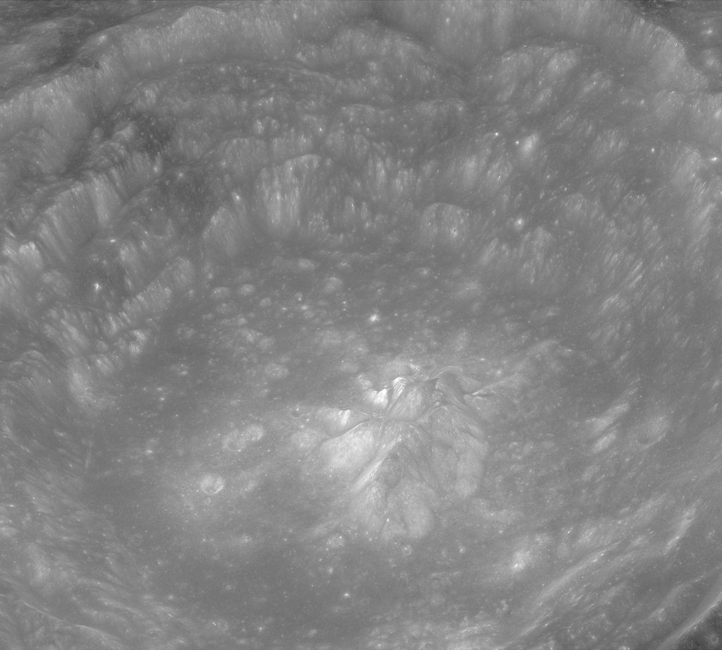
Investigations of the central peaks (where the deepest material these kinds of craters excavate is deposited) of nearside equatorial crater Bullialdus (60.7 km, 20.7°S, 337.8°E) have detected rocks composed of magmatic water of a kind collected by Apollo using the NASA M3 radar instrument aboard the ISRO orbiter Chandrayaan-1. LROC Narrow Angle Camera (NAC) oblique observation M1099038207LR, spacecraft orbit 14313, August 8, 2012; overall resolution 2.4 meters, angle of incidence 48.8° with spacecraft and camera slewed 63.4° west of nadir, 73.65 kilometers over 20.96°S, 331.93°E [NASA/GSFC/Arizona State University].
NASA-funded lunar research has yielded evidence of water locked in mineral grains on the surface of the moon from an unknown source deep beneath the surface.

Using data from NASA's Moon Mineralogy Mapper (M3) instrument aboard the Indian Space Research Organization (ISRO) Chandrayaan-1 spacecraft, scientists remotely detected magmatic water, or water that originates from deep within the moon's interior, on the surface of the moon.

The findings, published by letter, August 25, in Nature Geoscience, represent the first detection of this form of water from lunar orbit. Earlier studies had shown the existence of magmatic water in lunar samples returned during the Apollo program.

M3 imaged the lunar impact crater Bullialdus, which lies near the lunar equator. Scientists were interested in studying this area because they could better quantify the amount of water inside the rocks due to the crater's location and the type of rocks it held. The central peak of the crater is made up of a type of rock that forms deep within the lunar crust and mantle when magma is trapped underground.

"This rock, which normally resides deep beneath the surface, was excavated from the lunar depths by the impact that formed Bullialdus crater," said Rachel Klima, a planetary geologist at the Johns Hopkins University Applied Physics Laboratory (APL) in Laurel, Maryland.

"Compared to its surroundings, we found that the central portion of this crater contains a significant amount of hydroxyl - a molecule consisting of one oxygen atom and one hydrogen atom -- which is evidence that the rocks in this crater contain water that originated beneath the lunar surface," Klima said.

LROC Wide Angle Camera (WAC) 100 meter per pixel mosaic of Bullialdus, an illustration for the post "Bullialdus Central Peak Oblique," January 23, 2013 [NASA/GSFC/Arizona State University].
In 2009, M3 provided the first mineralogical map of the lunar surface and discovered water molecules in the polar regions of the moon. This water is thought to be a thin layer formed from solar wind hitting the moon's surface. Bullialdus crater is in a region with an unfavorable environment for solar wind to produce significant amounts of water on the surface.

"NASA missions like Lunar Prospector and LCROSS (the Lunar Crater Observation and Sensing Satellite) and instruments like M3 have gathered crucial data that fundamentally changed our understanding of whether water exists on the surface of the moon," said S. Pete Worden, center director at NASA's Ames Research Center in Moffett Field, Calif. "Similarly, we hope that upcoming NASA missions such as the Lunar Atmosphere and Dust Environment Explorer, or LADEE, will change our understanding of the lunar sky."

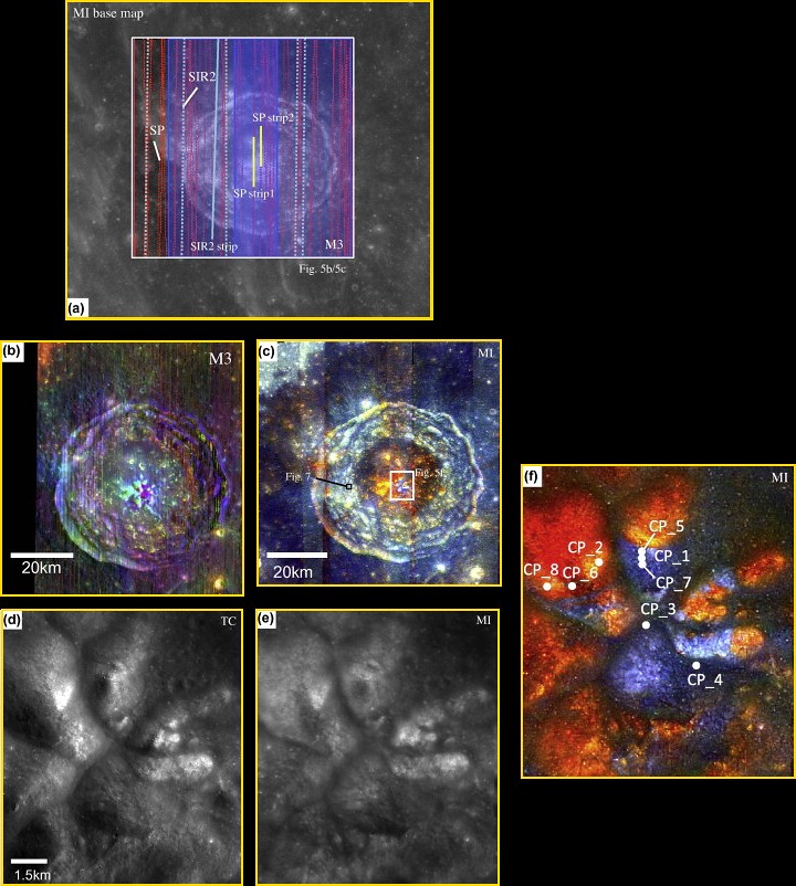
Combined data for the Bullialdus area
Figure 5 from "One Moon, Many Measurements 3: Spectral reflectance," Science Direct (Icarus, Vol 226, #1, Sept.-Oct. 2013) Combined data for the Bullialdus area. (a) Location of available datasets of the Bullialdus region: gray scale base map, MI; red dots, SP traverses; blue shading, M3 scene width; light-blue dots, SIR-2 traverses. SP/M3/SIR-2 datasets within the white box are presented in this figure. The white box corresponds to the area shown in (b) and (c). TC data cover the entire area. Data included in Table 2 for SP are indicated in yellow, and those for SIR-2 are solid light blue. (b) M3 color-composite image. Band assignments are integrated band depth at 1 μm (red), integrated band depth at 2 μm (green), and 1.5 μm albedo (blue). A manual shadow mask has been applied, primarily on the west (left) crater wall. (c) MI color-composite image. Red denotes the continuum-removed absorption depth of 0.95 μm, green denotes that of 1.05 μm, and blue denotes that of 1.25 μm. (d) TC image of the central part of the Bullialdus central peak. (e) MI 750 nm-band image after photometric correction using local topographic information. (f) MI color-composite image of the center of the Bullialdus central peak. (For interpretation of the references to color in this figure legend, the reader is referred to the web version of this article.)

The detection of internal water from orbit means scientists can begin to test some of the findings from sample studies in a broader context, including in regions that are far from where the Apollo sites are clustered on the near side of the moon. For many years, researchers believed that the rocks from the moon were bone-dry and any water detected in the Apollo samples had to be contamination from Earth.

"Now that we have detected water that is likely from the interior of the moon, we can start to compare this water with other characteristics of the lunar surface," said Klima. "This internal magmatic water also provides clues about the moon's volcanic processes and internal composition, which helps us address questions about how the moon formed, and how magmatic processes changed as it cooled."

APL is a not-for-profit division of Johns Hopkins University. Joshua Cahill and David Lawrence of APL and Justin Hagerty of the U.S. Geological Survey's Astrogeology Science Center in Flagstaff, Arizona co-authored the paper.

NASA's Lunar Advanced Science and Engineering Program, the NASA Lunar Science Institute (NLSI) at Ames and the NASA Planetary Mission Data Analysis Program supported the research. NLSI is a virtual organization jointly funded by NASA's Science Mission Directorate and NASA's Human Exploration and Operations Mission Directorate in Washington, to enable collaborative, interdisciplinary research in support of NASA lunar science programs.

Monday, April 8, 2013

The Mystery of Shackleton Crater

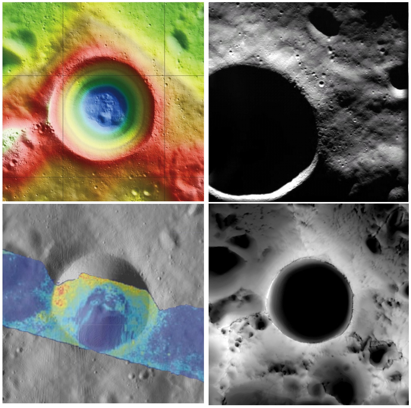
Shackleton crater, Earth's Moon. Clockwise from top left: topography from (LOLA) laser altimetry, photography from ESA SMART-1 mission, lighting map (relative isolation - brighter indicates longer periods of illumination) from LROC data, Mini-RF Circular Polarization Ratio (CPR) image draped over shaded relief. The crater is about 20 km across.
Paul D. Spudis
The Once and Future Moon
Smithsonian Air & Space


Though unremarkable in appearance compared to the roughly 4,000 craters on the Moon in its size range, the 20 km diameter crater Shackleton has been the source of relentless scientific controversy for the past 20 years.  Shackleton is located at the south pole of the Moon; indeed, its near side rim is the precise location of the geographic pole itself.   Its location makes observation by Earth-based telescopes difficult and it was not well photographed by the Lunar Orbiter series (our principal source of lunar images) of the 1960s.  That all changed in 1994 with the flight of the joint DoD-NASA mission to the Moon, Clementine.

Clementine carried cameras that globally imaged the Moon in eleven visible and near-infrared wavelengths.  In addition, it mapped the surface and lighting of the poles of the Moon at uniform resolution over the course of almost three lunar days (74 Earth days).  When the Science Team first saw the south polar mosaic, the extent of darkness in the map was striking.  Because the Moon’s spin axis is close to perpendicular to the ecliptic plane, the Sun is always at the horizon at the lunar poles.  Instead of rising and setting, the Sun circles around the poles at or near the horizon.  Because of this grazing incidence, an area in a topographic depression may be in permanent shadow.  And so it appeared for Shackleton crater in the Clementine data, setting off bells in the heads of the Science Team.

Intuitive selection from HDTV still frame captured by Japan's lunar orbiter SELENE-1 (Kaguya) in 2008 shows Shackleton, with the Moon's south pole on its rim (upper left) in relation to Earth and Malapert Massif, part of the nearside rim of the ancient South Pole-Aitken impact basin, along the line of sight. Shackleton's interior and the craters between it and Malapert, are permanently shadowed interiors (PSR), unmapped before the 21st century [JAXA/NHK/SELENE].
A key controversy of the post-Apollo era was whether the lunar poles might contain water or not.  Although the Apollo samples had been studied and found to be “bone-dry,” we had not been to the poles on any Apollo mission.  We knew that any shadowed areas had to be extremely cold as well as permanently dark.  As water-bearing debris in the form of asteroids and comets constantly strike the Moon, it was thought that some of that water might get into a polar “cold trap” and would be kept there (essentially) forever – billions of years of impacting cosmic “debris” can add up.

Clementine was not configured to measure the presence of water, but a cleverly improvised experiment used the spacecraft’s data transmitter to beam radio waves into the dark regions near the poles and listen to their reflected echoes on the enormous (70 m) dish antenna of NASA’s Deep Space Network.  Interestingly, the reflections indicated an enhancement of “same sense” polarization within the (very large) resolution cell that contained Shackleton crater.  A collect of data from a nearby sunlit area (taken as an experimental control) did not show this peak.  The Clementine team interpreted the RF peak as evidence for the presence of a few percent water ice within the dark, cold interior of Shackleton crater.  The media quickly spread the startling news about water on our “bone-dry” Moon.

Shackleton, as seen in a joint 70 mm radar experiment collected by radio telescopes at Greenbank and Arecebo during a favorable libration opportunity in 2006.
Such a controversial conclusion did not go unchallenged.  Some in the radar community argued that abundant wavelength-sized rocks on the surface were the source of the enhanced same sense reflection.  Since the lunar surface is indeed rocky, this interpretation could not be ruled out.

Then a few years later, the Lunar Prospector (LP) mission found an enhancement of hydrogen concentration at both poles of the Moon; as hydrogen is a major constituent of water, the idea ice exists in the dark areas gained credence and has lead to a decade-long scientific search (using a variety of techniques) for lunar polar ice.  Though many areas near the poles were studied in detail, attention continued to be drawn back to Shackleton and the area near the south pole.

From studying Clementine images, we discovered that part of the rim crest of Shackleton is one of the most sunlit areas on the Moon.  Now we had a double-attraction: constant sunlight with water ice nearby.  At a press briefing in 1996, I called this area of water and sunlight “the most valuable piece of real estate in the Solar System.” Nothing found subsequently has changed my mind on that judgment.

So what have we learned about Shackleton lately?  Many different, new sensors have flown to the Moon in the last few years, including radar, ultraviolet (UV) imaging, laser reflections, and low-light level imaging.  And yet again, Shackleton crater continues to confound us with contradictory evidence, both for and against the presence of water ice in its interior.

In 2009, the question regarding the presence of water ice somewhere near the lunar south pole was answered when the LCROSS impactor threw up a cloud of water vapor and ice particles during its collision with the floor of the nearby crater Cabaeus.  Spectral mapping instruments on three different spacecraft (Chandrayaan-1, Cassini, and EPOXI) documented the presence of adsorbed water on the lunar surface, increasing in concentration with latitude toward both poles.  A small impact probe flown by India (MIP) passed through a water vapor zone in the exosphere just above the lunar south pole.  And radar images from Mini-RF, our radar imaging experiment on both Chandrayaan-1 and Lunar Reconnaissance Orbiter (LRO), found evidence of high same sense reflections (just as Clementine had suggested in 1994) within the interior of Shackleton crater.

LRO Mini-RF instrument radar data indicate the walls of Shackleton crater may, indeed, hold ice, confirming exacting measurements of laser altimeter (LOLA) point brightness studies revealed in June. Actual observations (CPR) are compared to calculated radar values for 0.5% to 10% ice. Illustration to post "Mini-RF adds to evidence of ice on Shackleton walls," September 1, 2012 [NASA ].
These new lines of supporting evidence were countered by Japanese researchers, whose Kaguya spacecraft imaged the interior of the crater and found morphology similar to other lunar craters in the same size-class.  But no one had ever claimed that the interior of Shackleton was a skating rink of pure ice – the lunar polar ice is partly covered by waterless dust and mixed with an unknown amount of dry regolith.

Interpretation of the new data continues to vex us.  The LOLA (laser altimeter) team on LRO recently published a paper that documents the high reflectivity (at 1 micron wavelength) of the walls of Shackleton.  Although the team’s favored interpretation is that this is caused by a constant exposure of fresh material on a steep slope, they also note that it is consistent with the presence of water ice on the walls of the crater.

In addition, a team analyzing neutron spectrometer data from both LP and LRO found evidence in the fast neutron data (never before analyzed) that water in the interior of Shackleton is a possible explanation for its signal.  Detailed analysis of the Mini-RF data for Shackleton corrected for its steep wall slopes and found that the presence of 5-10 wt.% water there provides the best model fit to the observed data.  Newly obtained UV images from LRO show the existence of water frost in the interiors of the craters Haworth and Shackleton, and the neutron detector on LRO shows enhanced hydrogen within both Shoemaker and Shackleton craters.  The Japanese team from Kaguya continue to insist that the no-ice interpretation is the correct one.

So we are left with a mystery.  Some evidence is pro-ice and some is contra-ice.  I find it interesting that for most of the investigators, new data does not necessarily change any minds, but tends to be interpreted in a way most favorable to their previously published ideas.  This should not be terribly surprising; the people who have argued for some specific interpretation presumably did so for good reasons and desire hard and clear-cut evidence to the contrary before abandoning a previously held position, one no doubt reached after much thought and soul-searching.

Less so, but still-mysterious Shackleton, "twice as deep as the Grand Canyon," from "Tour of the Moon," a 2:30 video prepared by the Science Visualization Studio (SVS) at Goddard Space Flight Center in 2012 [NASA/GSFC/SVS].
The way to unravel the water-ice mystery is to go to the surface of the lunar south pole (or both poles) and measure the composition of the surfaces in question.  Getting a definitive answer about the nature of lunar water would be game changing.   Some say the bigger mystery is:  Why hasn’t the United States sent a rover to the south pole of the Moon to take a closer look?

Originally published April 8, 2013 at his Smithsonian Air & Space blog The Once and Future Moon, Dr. Spudis is a senior staff scientist at the Lunar and Planetary Institute. The opinions expressed are those of the author but are better informed than average.

Related Posts:
Mini-RF adds to evidence of ice on Shackleton walls (September 1, 2012)
Shackleton harbors ice after all (June 12, 2012)
1000 Day Anniversary of LROC Imaging (March 27, 2012)
Shackleton on a Summer's Day (March 26, 2012)
Shadowed fluffy lunar frost detected in starlight (January 14, 2012)
Shackleton: Out of the Shadows (September 17, 2009)