Showing posts with label Keith Cowing. Show all posts

Saturday, January 18, 2014

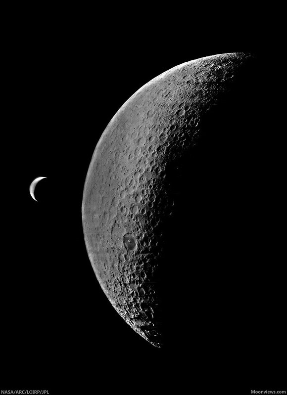
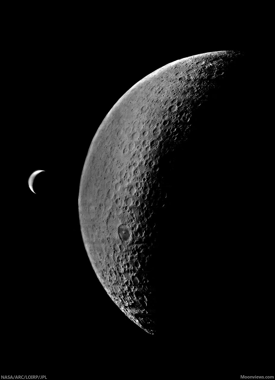
Another original earthrise, recovered

LOIRP-4123_M-19670517-20140117L
On the left is a newly recovered and enhanced image of the Earth and Moon taken by Lunar Orbiter IV on 19 May 1967. On the right is how the image has looked in NASA's records - until now [LOIRP/Moonviews.com].
Keith Cowing
Lunar Orbiter Image Restoration Project
Moonviews.com

The other day, as we were going through tapes from Lunar Orbiter IV we came across a picture of the Earth and the Moon - one that was not instantly familiar to us.

Read the full description,
and familiarize yourself with
the important work
of the LOIRP,
HERE.
Lunar Orbiter IV-123-M

Thursday, November 21, 2013

Apollo 12 ALSEP first to measure dust accumulation

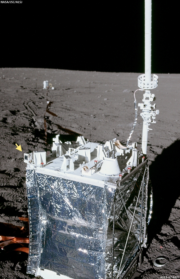
Apollo 12 ALSEP Central Station
Apollo 12 ALSEP, Central Station, with DTREM (Lunar Dust Collector) marked with arrow. Alan J. Bean, EVA-1;  Oceanus Procellarum, November 19, 1969 (AS12-47-6927) [NASA/JSC/ALSJ].
A dataset thought to have been lost, from an ingenious experiment deployed on the Moon by Apollo astronauts more than four decades ago, has been rediscovered and analyzed. As a result, the Lunar Dust Collector deployed as integral to the Apollo 12 ALSEP system, has become the first instrument to record a measurable rate of dust accumulation on the lunar surface. 

The news is timely, of course, coming the beginning of the Lunar Atmosphere and Dust Environment Explorer (LADEE) science mission, and arriving on November 19, the 44th anniversary of the Apollo 12 expedition.

Keith Cowing
Moonviews.com (LOIRP)

The Lunar Dust Detector, attached to the corner of (the ALSEP Central Station, pictured above), left by the Apollo 12 astronauts, made the first measurement of lunar dust accumulation. As the matchbox-sized device's three solar panels became covered by dust, the voltage they produced dropped.

When Neil Armstrong took humanity's first otherworldly steps in 1969, he didn't know what a nuisance the lunar soil beneath his feet would prove to be. The scratchy dust clung to everything it touched, causing scientific instruments to overheat and, for Apollo 17 astronaut Harrison Schmitt, a sort of lunar dust hay fever. The annoying particles even prompted a scientific experiment to figure out how fast they collect, but NASA's data got lost.

AS17-145-22157
Retrieving a surface sample behind boulders on a crater rim at Apollo 17 Science Station 5, Taurus Littrow valley; December 12, 1972 - Lunar module pilot and geologist Harrison Schmitt already carries a substantial sampling of abrasive, fine lunar dust on his moon suit. Schmitt endorsed development of 'dust mitigation' technology as a high priority for program planners prior to establishing 'extended human activity' on the Moon (Eugene Cernan - AS17-145-22157) [NASA/JSC/ALSJ].
Or, so NASA thought. Now, more than 40 years later, scientists have used the rediscovered data to make the first determination of how fast lunar dust accumulates. It builds up unbelievably slowly by the standards of any Earth-bound housekeeper, their calculations show -- just fast enough to form a layer about a millimeter (0.04 inch) thick every 1,000 years. Yet, that rate is 10 times previous estimates. It's also more than speedy enough to pose a serious problem for the solar cells that serve as critical power sources for space exploration missions.

Tuesday, June 11, 2013

Lunar Orbiter images last seen 47 years ago

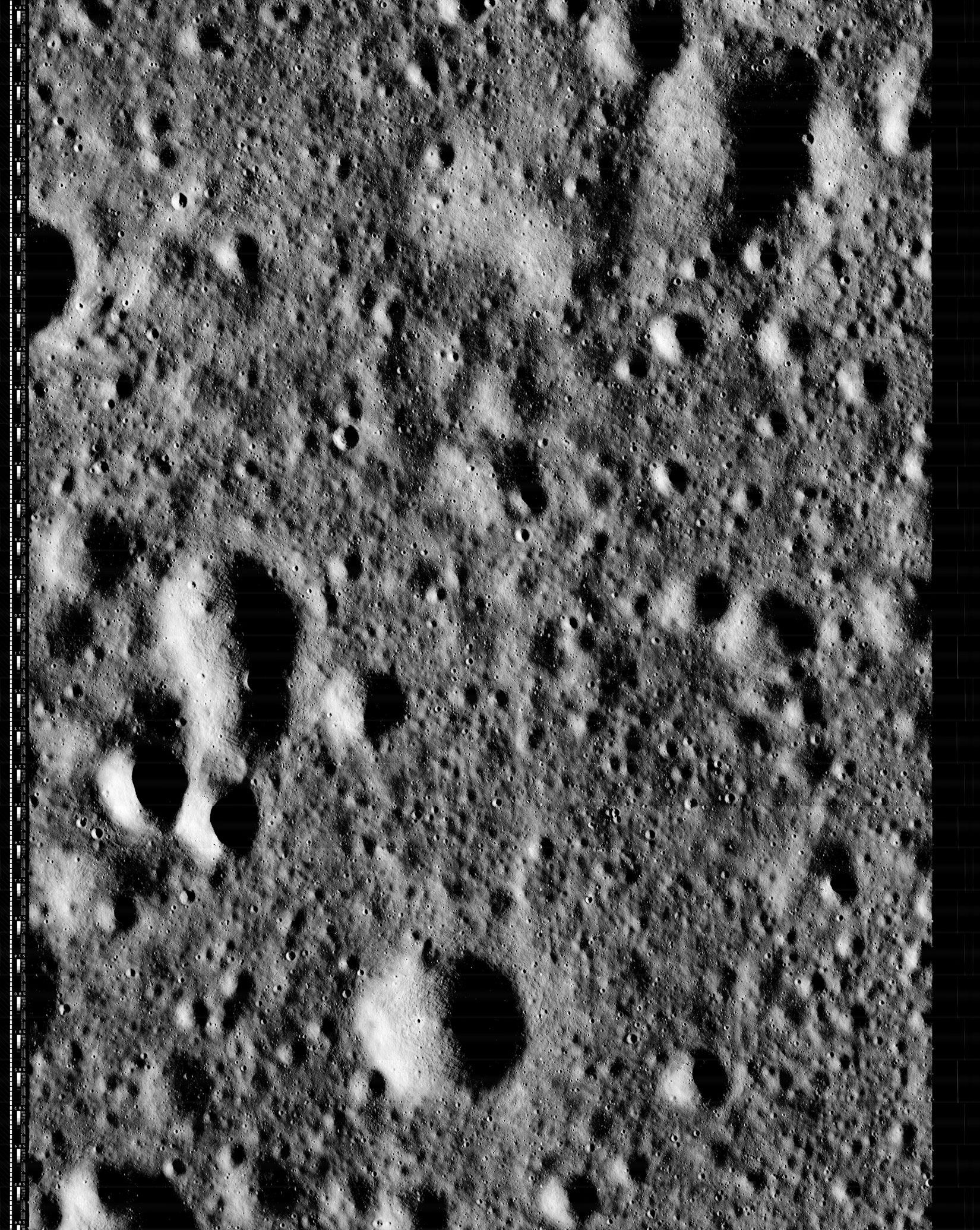
Lunar Orbiter 2 frame 159 (H2), an approximately 4.5 by 6 kilometers stretch of lunar mare 250 km southwest of Copernicus. One of three high-resolution photographs swept up, developed, scanned and radioed back to Earth in 1966. The fully-restored, previously incomplete session has been restored by the Lunar Orbiter Image Restoration Project (LOIRP).
Keith Cowing
LOIRP

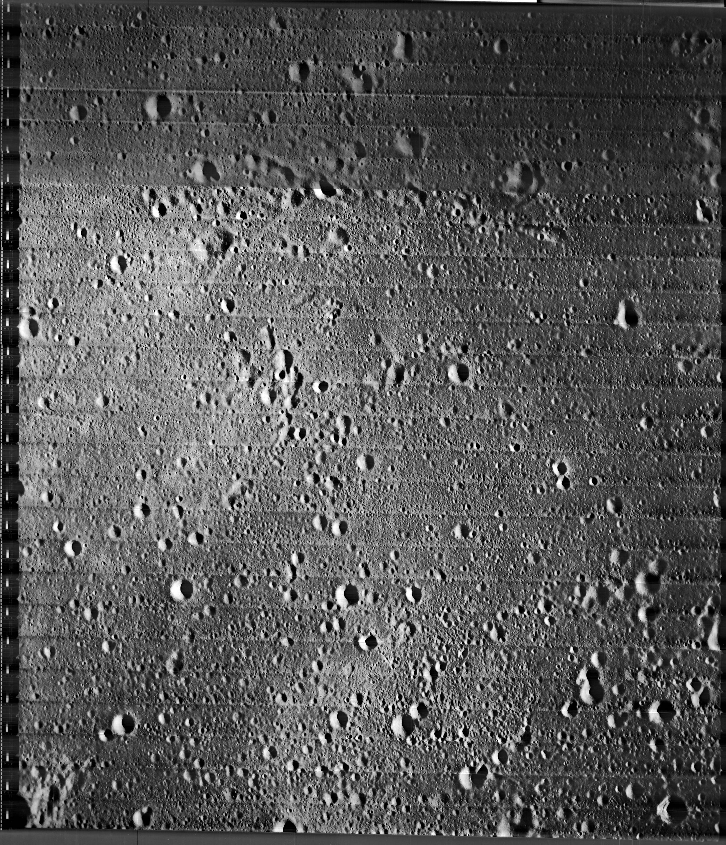
After being forgotten for nearly 47 years, three high resolution images taken by the Lunar Orbiter II spacecraft have been rediscovered by the Lunar Orbiter Image Recovery Project (LOIRP).

It is unlikely that anyone has seen these images since they were sent back to Earth. Indeed, it is unlikely that very many people saw them at that time either.

The three high resolution images were taken along with a medium resolution image on 23 November 1996 at 17:05:39 GMT. The center point of the images was 26.94 West Longitude, 3.196 degrees North Latitude. The images were taken at an altitude of 43.6 km and the image resolution is 0.93 meters.

Thumbnail of the medium resolution image, from the Lunar and Planetary Institute catalog. The area captured at high resolution in November 1966 is outlined at center. The area seen in "H2" above is outlined in yellow. This region is characterized by ejecta and secondary craters, primarily radiant from the Copernicus impact from 250 km northeast.
We recently came across these three images (#2159) and noticed that they do not appear online at the LPI Lunar Orbiter database. Only the medium resolution image gets mentioned at LPI.

These three images were retrieved from original Lunar Orbiter program analog data tapes yet they appear nowhere in NASA's publications. They do appear on microfilm archives at LOIRP and are mentioned in a simple data log online at LPI. LOIRP has a more extensive computer printout of this data that shows more detail about the images - but not the images themselves.

Among the highest resolution Wide Angle Camera images of the region, among LROC images thus far released to the Planetary Data System (PDS), the area of interest is smaller than a postage stamp, above the right (east) central edge of this 32.4 km-wide field of view from LROC Wide Angle Camera (WAC) observation M166025782C (604 nm), LRO orbit 9601, July 23, 2011; 62.86° angle of incidence, resolution 55.85 meters per pixel from 40.64 km [NASA/GSFC/Arizona State University].
Unless someone happened to be looking through this microfilm collection (LOIRP has the only extant copy) then it is pretty safe to assume that no one has actually seen these images since a technician saw them on a TV monitor in 1966.

Read the full article, catch up on the Lunar Orbiter Image Restoration Project,
and discover how you can help
, HERE.

Thursday, August 2, 2012

Tranquility Base at high-resolution before Apollo 11

On Monday, August 1 the Lunar Orbiter Image Restoration Project (LOIRP) released another 'newly retrieved' medium resolution frame 2085 M, originally photographed by Lunar Orbiter II on November 20, 1966, from its vantage point 51.4 kilometers over the southwest Mare Tranquillitatis (0.8°N, 23.7°E).
The Lunar Orbiter Image Restoration Project (LOIRP) has released an image from 1966, showing 'Tranquility Base' before the arrival of Apollo 11, newly-retrieved from once-discarded Lunar Orbiter telemetry tapes using restored and equipment built from scratch to read them.

It was early mid-morning on the Sea of Tranquility and the eventual landing site of Apollo 11 (small blue arrow in the thumbnail image, above) only 32 months later, when Lunar Orbiter II photographed the historic location. 

A very large version of the image, newly retrieved from the original taped telemetry returned from the JPL orbiter, at a digital resolution of 16500 x 18564 pixels (598.3 Mb) is housed at the NASA Lunar Science Institute, HERE. Original reproductions of second-generation photographs, along with image references, are available at the Lunar and Planetary Science Institute, HERE.

A large 1650 x 1856 version is available from the Moonviews.com website, HERE. Detailed full-resolution views of the landing site of Apollo 11 before and after July 20, 1969 are visible in the images below.

A rough outline of the field of view captured by Lunar Orbiter II traced out on the global LROC Narrow and Wide Angle Camera mosaic on the LROC QuickMap web-application, at a resolution of 64 meters. The Apollo 11 landing site is indicated by the red cross [NASA/GSFC/Arizona State University].
The Apollo 11 descent stage (blue arrow) is clearly visible when the LROC QuickMap is reset to 2 meters resolution, a close match to the full resolution close-up on the same area photographed by Lunar Orbiter II a year and eight months before the landing, below
A quick examination of the 16500 x 18564, 600 Mb full resolution version of LO-II-085 shows the landing site and many details of the vicinity familiar to those acquainted with mission details, before the arrival of Apollo 11. Excellent detail for this media, even without teasing out more detail using present-day software [NASA/JPL/LOIRP/NLSI].

Thursday, July 12, 2012

The Spirit of the Lunar Orbiters lives in LOIRP

Newly retrieved high-resolution frame (Lunar Orbiter II-13-H2) showing a roughly 4 km-wide area in  south Mare Tranquillitatis, originally photographed, processed and radioed back to Earth by the Lunar Orbiter spacecraft November 18, 1966. It is the center (h2) of three sequential high-res frames captured simultaneous to the imaging of medium resolution Lunar Orbiter observation 2-013. It has been remastered and just released by the remarkable Lunar Orbiter Image Restoration Project (LOIRP) working on the campus of NASA's Ames Research Center in California [Moonviews].
Joel Raupe
Lunar Pioneer

In addition to the five spacecraft the United States presently has in lunar orbit, the legacies left behind by the five Lunar Orbiter spacecraft dispatched in 1966 and 1967, ahead of the manned Apollo landings, collectively amount to a sixth mission, still active and present in more than spirit. Because of the vision and resourcefulness of a special group of engineers and scientists the original tapes containing the raw radio signal returned by the Lunar Orbiters is methodically being processed, essentially for the first time, almost fifty years later. The most recent release of frames originally photographed by Lunar Orbiter II late in 1966 provide us with an easy demonstration of where this growing new library of half-century-old observations fits into our 21st century understanding of the Moon.

Any new craters? On December 21, 2009 the Lunar Reconnaissance Orbiter Camera team swept up much of the territory photographed at high resolution by Lunar Orbiter II in November 1966. The field of view in L2013-H2 is here outlined in yellow. LROC Narrow Angle Camera (NAC) observations M116072806L & R, orbit 2239; angle of incidence 80.6° at 0.96 meters resolution, from 46.3 km [NASA/GSFC/Arizona State University].
Much of the area in the three Lunar Orbiter II high-resolution photographs was surveyed at least once, under a high angle of illumination (80.7°) at slightly better than 1 meter resolution, December 21, 2009. The upper right hand portion of Lunar Orbiter frame 2013 (h2) is also available in the body of Lunar Reconnaissance Orbiter Camera high-resolution Narrow Angle Camera (NAC) observations presently released to the Planetary Data System.
Newly retrieved by the Lunar Orbiter Image Restoration Project (LOIRP), the medium resolution Lunar Orbiter frame 2011 (M) shows a roughly 45 km-wide area in south central Mare Tranquillitatis originally photographed by Lunar Orbiter II, November 18, 1966 (1525 UT). Of the three high-resolution frames of the area, engineered to be captured at the same opportunity, the center frame, h2, is thinly outlined in very pale yellow at the direct center, and is detailed above [Moonviews].
A 3200 square kilometer field of view showing the immediate area of southeast Mare Tranquillitatis visible in a set of two medium and three high-resolution Lunar Orbiter photographs newly retrieved and just released by the Lunar Orbiter Image Restoration Project (LOIRP). The white rectangle outlines cover the area of the lunar surface in two LROC NAC observations overlapping the high-resolution Lunar Orbiter II frames. Fields of view in the Lunar Orbiter high-resolution frames were re-surveyed at high-resolution by the Lunar Reconnaissance Orbiter, 45 years later. LROC QuickMap at 64 meters resolution, LROC WAC Global 100 meter monochrome mosaic [NASA/GSFC/Arizona State University].
LROC QuickMap 4000 meter resolution context view showing the 3200 square km area of the southeast Sea of Tranquility framed in the image immediately above. This part of the Tranquillitatis basin averages out at a bit higher elevation than elsewhere, and is populated by ancient inundated ghost crater rims with the coherent spatter of secondary craters. As our understanding of lunar morphology deepens it has become less clear whether Mare Tranquillitatis constitutes a true basin. Regardless, however, episodic re-floodings by molten material has left behind some of the Moon's deepest mare strata, even if Tranquility is not as clearly defined, horizontally and vertically, as the Serenitatis, Crisium, Nectaris or Imbrium basins nearby [NASA/GSFC/Arizona State University].

The story behind the recovery and retrieval of Lunar Orbiter photography is pretty amazing. The precision design of the spacecraft and their cameras - designed to shoot simultaneous images on film, to then develop that film and televised the result back to Earth - through to the 21st century story labor of love behind how unique and original tapes were housed in a former McDonalds and the nearly extinct drives and software needed even to begin reading those rediscovered tapes were brought online reads like a detective story. The result has been  to retrieve images at a quality better than any that had been available for decades, and a virtual sixth mission to complement the present-day 21st century flotilla now in orbit (after a very long drought).

The "older" photography can be used for a variety of important purposes, but in the context of the robust LRO photographic survey, now beginning an unprecedented third year in lunar orbit, no price can be placed on the opportunity to search out the rate of new impacts among the slow changes in the lunar landscape over five decades. And despite its clear strengths as a marvel of engineering and on-time, on budget performance, even the LRO will not be capable of surveying the entire lunar surface at high-resolution (though, so far, the LROC team surveyed much more than half). The release of newly retrieved Lunar Orbiter images. like these "fresh" from 1966, fills some of those gaps nicely, and also provides the opportunity to see the same area of the Moon at high resolution under different lighting conditions.

Meanwhile, the LROC Wide Angle Camera has been able to survey the entire visible lunar surface under a variety of lighting conditions at an extraordinary "medium" resolution.

The original and latter history of the Lunar Orbiter legacy amounts to a heroic story, one made possible by forward-thinking scientists like Gene Shoemaker, and thoughtful people who might have tossed the tapes but instead carefully packed them. Their rediscovery and the dedicated people who rebuilt the capacity to read those tapes makes for interesting reading as well. It also provides us with a lesson about the transitory nature of magnetic and digital media.

Today's Blue-Ray may be tomorrow's Eight-Track tape!

Some earlier posts and background on LOIRP (Moonviews.com):
The LOIRP time machine looks back 43 years (June 3, 2010)
New releases from Lunar Orbiter II (1966) - (May 7, 2010)
Boulders of Copernicus (December 11, 2009)
LOIRP: Boulder Trails on the Moon (December 10, 2009)
Lunar Orbiter's originals vs. LOIRP restorations (December 9, 2009)
New restored detail from Lunar Orbiter II (December 8, 2009)
LOIRP configures second FR-900 tape drive (November 12, 2009)
LOIRP remasters the Moon's South Pole (August 14, 2009)
Lockheed Martin donates Clean-Room to LOIRP (August 12, 2009)
LOIRP astounds again, re-release of LO-II0162 (1967)
with each of three high-res sub-frames
(August 10, 2009)
Full Earth, as seen by Orbiter V (August 7, 2009)
Lunar Orbiter III-154-H2 (June 16, 2009)
LOIRP recovers Lunar Orbiter IV lunar South Pole image from 1967 (June 16, 2009)
LOIRP recovers detail of Fra Mauro and future landing site of Apollo 14 (June 11, 2009)
New LOIRP high res Lunar Orbiter image of western Oceanus Procellarum (June 10, 2009)
LOIRP recovers image of Ranger 8 impact (June 9, 2009)
LOIRP's "Pictures of the Century" (March 23, 2009)
More astounding new detail from LOIRP (February 26, 2009)
Breakthrough in Lunar Orbiter photograph remastering (February 20, 2009)

Inside the Lunar Orbiter Image Recovery Project

The "McMoon" facility on the campus of Ames Research Center [Moonviews].
Maggie Koerth-Baker
boingboing

If these photos of NASA's Lunar Orbiter Image Recovery Project look suspiciously like they might actually have been taken inside an abandoned McDonalds ... well, that's very observant of you. All of those film canisters you see in the first image are actually spools of 70mm magnetic tape containing the analog originals of images taken by the Lunar Orbiter spacecraft in 1966 and 1967. After sitting in storage for decades—most notably in a barn in California—the tapes were brought to the NASA Ames Research Center in 2007. Since then, some of the originals have been digitized and preserved. (There's a good chance you saw a few in 2008, when the first preserved images were released.) Others are still in process. There's not much funding for this type of work, and it can get expensive, as it involves maintaining extremely rare FR-900 tape drives.

Read the entire post at boingboing.net

Thursday, May 24, 2012

Re-release of Iconic Copernicus 'Image of the Century'

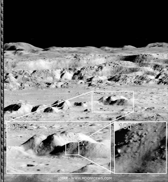
Newly processed high-resolution detail from an unprecedented oblique view of the interior of Copernicus captured by Lunar Orbiter 2, from the "Image of the Century" photographed November 24, 1966. Higher and full resolution images are linked to the Moonviews (LOIRP) announcement, HERE [LOIRP].
Keith Cowing
Lunar Orbiter Image Recovery Project
moonviews.com
NASAWatch.com


Today an iconic image from the initial exploration of the Moon is being re-released showing detail that could not have been seen using technology available at the time the photo was taken. This image features a dramatic view inside the majestic crater Copernicus - a view that left millions in awe when it was first released.

This image was announced at the First Global Space Exploration Conference, co-sponsored by the AIAA and IAF, in Washington, DC.

Between 1966 and 1967 NASA sent five Lunar Orbiter spacecraft to the Moon. Their job was to survey the surface to help determine landing sites for the upcoming Apollo missions. In addition to their recon role, these spacecraft also contributed to the nascent scientific understanding of the Moon. But every once in a while these spacecraft also served as artists, snapping photos of this nearby world in a way that human eyes had never been able to see before.

New magnification possible using the 21st century techniques employed by LOIRP. Higher and full resolution images are linked to the Moonviews (LOIRP) announcement, HERE [LOIRP].
Once such image was taken of crater Copernicus on 24 November 1966 by the Lunar Orbiter 2 spacecraft. What made this photo so unique was the oblique angle it was taken at as well the close proximity of the spacecraft to its target. The image was taken at an altitude of 45 km (27.1 miles) at a distance of approximately 207.7 km (~125 miles) from the center of the crater. Instead of looking down, the spacecraft looked sideways at the Moon.

The bouldered area of the central peaks of Copernicus seen newly sampled at "100 percent" in the image further up were swept up by the Lunar Reconnaissance Orbiter Camera in orbit 909, September 9, 2009; LROC Narrow Angle Camera (NAC) observation M107006443R; resolution 1.15 meters (shown here at 4 meters per pixel) from an altitude of 130.11 kilometers [NASA/GSFC/Arizona State University].
For the first time people saw the Moon as a world with mountains and boulders and other features (some of them strange) that were not apparent from photos where the view was looking straight down. So taken were people at the time that Life Magazine took to calling the photo "The Picture of the Century"

Read about the full details in the original article, HERE.

Wednesday, March 28, 2012

Jeff Bezos finds Apollo 11-Saturn V First Stage

Separation and staging of the Apollo 11-Saturn V First Stage, July 16, 1969, from the Airborne Lightweight Optical Tracking System (ALOTS), a 70mm camera mounted on an Air Force EC-135N. Separation occurred at an altitude of 60 kilometers, 81 kilometers downrange from Pad 39A, Kennedy Space Center [NASA].
Marc Boucher
via NASA Watch

"I'm excited to report that, using state-of-the-art deep sea sonar, the team has found the Apollo 11 engines lying 14,000 feet below the surface, and we're making plans to attempt to raise one or more of them from the ocean floor. We don't know yet what condition these engines might be in - they hit the ocean at high velocity and have been in salt water for more than 40 years. On the other hand, they're made of tough stuff, so we'll see."

F1-Engine Recovery - Bezos Expeditions

Monday, January 31, 2011

IAU names craters to honor Columbia crew

Columbia crater group, Apollo basin (Chang'e-2)
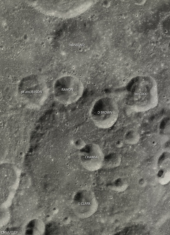
Craters in this grouping on the southeast side of the ancient Apollo basin have been preliminarily named in honor of the crew members of Space Shuttle Columbia, who perished during re-entry February 1, 2003.  Though some in the group seem to be large secondary craters from the same event Husband, formerly Borman L, is older than the others  Field of view from Chang'e-2 global high-Sun mosaic [CAS/CNSA/CLEP].
Keith Cowing, at the Lunar Orbiter Image Recovery Program (LOIRP) website "Moonviews" reports a crater grouping in Apollo basin (35.7°S, 208.0°E) has been provisionally designated by the International Astronomical Union to honor of each of the seven astronauts who died in the catastrophic failure of Space Shuttle Columbia February 1, 2003.

Columbia group, Apollo basin
Columbia crater group, in context with Apollo basin and craters there named after the Space Shuttle Challenger group, among others. The larger crater at center left, named in honor of Apollo 1 crew member Roger Chafee, is roughly 50 km across  [NASA/USGS/ASU].
Columbia crater group, lunar farside (LROC WAC DTM)
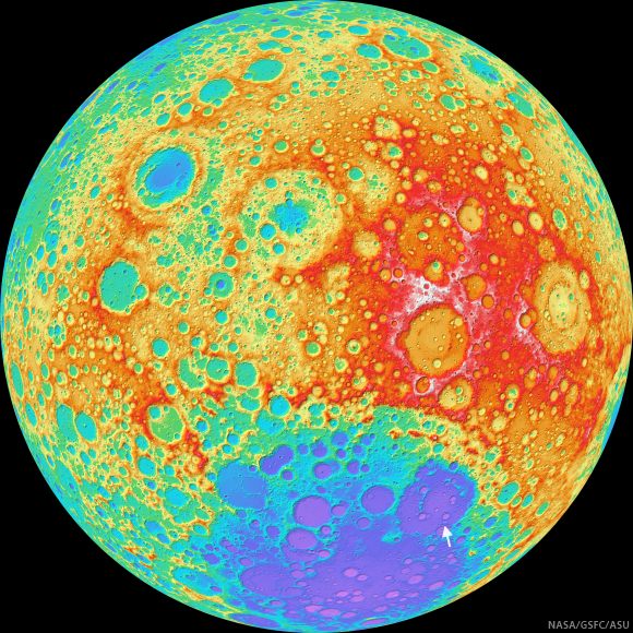
Locating the Columbia crater group (arrow) in Apollo basin, itself nested near the edge of the South Pole-Aitken basin, on an orthographic projection of the lunar farside. False color elevation map from LROC Wide Angle Camera digital terrain model (WAC DTM) [NASA/GSFC/ASU].