Showing posts with label ARC. Show all posts

Friday, February 14, 2014

LADEE's first images of the Moon

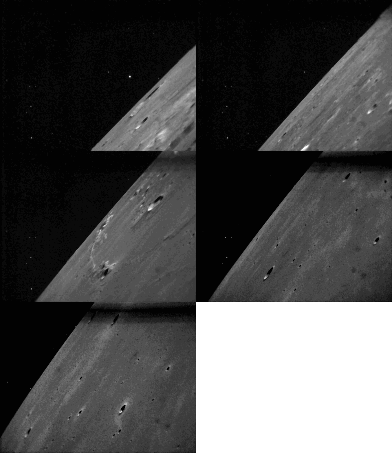
Series of LADEE star tracker images show the starfield against which the spacecraft baselines the data it collects eclipsed by the Moon below, as the short-lived mission's orbit skirts the northern edge of the Aristarchus plateau [NASA/ARC].
Rachel Hoover
NASA Ames Research Center

Earlier this month, NASA's Lunar Atmosphere and Dust Environment Explorer (LADEE) observatory successfully downlinked images of the moon and stars taken by onboard camera systems, known as star trackers. This is the first time the LADEE team commanded the spacecraft to send these pictures back to Earth.

The main job of a star tracker is to snap images of the surrounding star field so that the spacecraft can internally calculate its orientation in space. It completes this task many times per minute. The accuracy of each of LADEE's instruments' measurements depends on the star tracker calculating the precise orientation of the spacecraft.

"Star tracker cameras are actually not very good at taking ordinary images," said Butler Hine LADEE project manager at NASA's Ames Research Center in Moffett Field, California "But they can sometimes provide exciting glimpses of the lunar terrain."

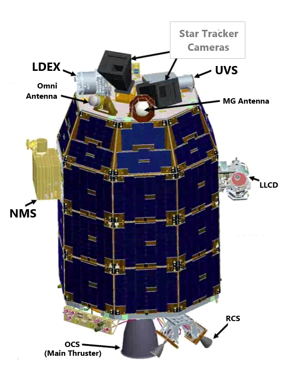
Given the critical nature of its assignment, a star tracker doesn't use ordinary cameras. Star trackers' lenses have a wide-angle field of view in order to capture the night sky in a single frame.

The images shown here were acquired on February 8, 2014, around 2345 UT, while LADEE was carrying out atmospheric measurements. The series of five images were taken at one-minute intervals, and caught features in the northwestern hemisphere of the moon. LADEE was traveling approximately 100 km per minute along its retrograde semi-equatorial orbit. All images were taken during lunar night, but with Earthshine illuminating the surface.

The initial image captured the smooth-floored crater Krieger (22.86 km, 29.02°N, 314.39°E) on the horizon, with 7 km Toscanelli in the foreground.

The second image shows Wollaston P, about 4 km across near the horizon, and the southeastern flank of the lunar mountain Mons Herodotus.

The third image caught a minor lunar mountain range Montes Agricola, the northwest frontier of the Aristarchus Plateau, as well as the flat-floored crater Raman, about 10 km in diameter.

Image four in the series captures 6 km Golgi and 5 km Zinner.

The final image views craters Lichtenberg A (6.9 km, 28.9°N, 299.89°E) and Schiaparelli E (4.9 km, 27.12°N, 297.93°E) in the smooth mare basalt plains of western Oceanus Procellarum.

LADEE (nomenclature)
Location of LADEE Star Tracker Cameras in relation to its primary components [NASA/LEAG].
The star trackers will operate while LADEE continues to measure the chemical composition of the atmosphere, collect and analyze samples of lunar dust particles in the atmosphere and hope to address a long-standing question: Was lunar dust, electrically charged by sunlight, responsible for the pre-sunrise glow above the lunar horizon observed during several Apollo missions? And who knows? The star trackers may help answer that question.

Friday, November 22, 2013

LADEE begins collecting data

NASA Ames / Dana Berry
NASA's Lunar Atmosphere and Dust Environment Explorer (LADEE) spacecraft, in orbit above the Moon, as dust scatters light during lunar sunset [NASA/ARC/JAXA/Dana Berry].
Rachel Hoover
NASA Ames Research Center

NASA's Lunar Atmosphere and Dust Environment Explorer (LADEE) is ready to begin collecting science data about the Moon.

On November 20, the spacecraft successfully entered its planned orbit around the Moon's equator -- a unique position allowing the small probe to make frequent passes from lunar day to lunar night. This will provide a full view of the changes and processes occurring within the moon's tenuous atmosphere.

LADEE now orbits the moon about every two hours at an altitude of 12 to 60 km above the Moon's surface. For about 100 days, the spacecraft will gather detailed information about the structure and composition of the thin lunar atmosphere and determine whether dust is being lofted into the lunar sky.

Scientists will be able to study the conditions in the atmosphere during lunar sunrise and sunset, where previous crewed and robotic missions detected a glow of rays and streamers reaching high into the lunar sky.

“This is what we’ve been waiting for – we are already seeing the shape of things to come,” said Rick Elphic, LADEE project scientist at NASA's Ames Research Center in Moffett Field, California

On November 20, flight controllers in the LADEE Mission Operations Center at Ames confirmed LADEE performed a crucial burn of its orbit control system to lower the spacecraft into its optimal position to enable science collection. Mission managers will continuously monitor the spacecraft's altitude and make adjustments as necessary.

"Due to the lumpiness of the moon's gravitational field, LADEE's orbit requires significant maintenance activity with maneuvers taking place as often as every three to five days, or as infrequently as once every two weeks," said Butler Hine, LADEE project manager at Ames. "LADEE will perform regular orbital maintenance maneuvers to keep the spacecraft’s altitude within a safe range above the surface that maximizes the science return."

In addition to science instruments, the spacecraft carried the Lunar Laser Communications Demonstration, NASA's first high-data-rate laser communication system. It is designed to enable satellite communication at rates similar to those of high-speed fiber optic networks on Earth. The system was tested successfully during the commissioning phase of the mission, while LADEE was still at a higher altitude.

LADEE was launched September 6 on a US Air Force Minotaur V, an excess ballistic missile converted into a space launch vehicle and operated by Orbital Sciences Corporation of Dulles, Virginia. LADEE is the first spacecraft designed, developed, built, integrated and tested at Ames, and it is the first probe launched beyond Earth orbit from NASA's Wallops Flight Facility on the Virginia's Eastern Shore.

NASA's Science Mission Directorate in Washington funds the LADEE mission. Ames manages the overall mission and serves as a base for mission operations and real-time control of the probe. NASA's Goddard Space Flight Center in Greenbelt, Maryland, manages the science instruments and technology demonstration payload, the science operations center and overall mission support. NASA's Marshall Space Flight Center in Huntsville, Alabama, manages LADEE within the Lunar Quest Program Office.

Wednesday, November 6, 2013

LADEE transitioning out of commissioning phase

LADEE in lunar orbit
Dana Berry's concept of the NASA Lunar Atmosphere and Dust Environment Explorer (LADEE) in low lunar orbit [NASA/ARC].
Rick Elphic
LADEE Project Scientist

Things are going very well on LADEE.  We've spent the last few weeks, following lunar orbit insertion, splitting our efforts between the laser communication (LLCD) demonstration activities and science instrument commissioning.

The lasercomm (Lunar Laser Communications Demonstration, LLCD) activities have been highly successful, with the LADEE space terminal linking up with the ground terminal at White Sands optically in no more than a few tens of seconds, without resorting to commanding through the conventional RF uplink.  Lasercomm has demonstrated downlink rates as high as 622 megabits/sec, and uplinks of 20 megabits/sec.  This downlink rate is sufficient to convey HD video (if LADEE had HD video!).

The three science instruments have been stepping through a series of tests to characterize their performance in orbit around the Moon, and have acquired preliminary science and engineering data in our high, 250-km altitude commissioning orbit.  

The Neutral Mass Spectrometer (NMS) has performed atmospheric ram measurements as well as special operations for looking at atmospheric ions, as well as species sputtered from the lunar surface.  The Ultraviolet-Visible Spectrometer (UVS) has performed a series of calibration activities, including stellar calibrations, solar viewer calibrations, and telescope boresight calibrations.  UVS has also carried out a number of limb scans above the sunset, noon and sunrise limbs.  The Lunar Dust Experiment has been making many measurements at the 250-km altitude, to characterize the particle impact rates and background in this orbit. 

LADEE will soon be transitioning out of commissioning phase, starting with a maneuver to lower periapsis to around 50-km altitude over the sunrise terminator.  This maneuver is planned for Sunday, November 10, at  around 04:30 UT.  Following this maneuver the science instruments will begin taking data in a more science-like configuration.

After a final block of lasercomm testing, LADEE will drop apoapsis to its operational altitude of approximately 100 km over the sunset terminator on November 20, and then LADEE's science mission truly begins in earnest.

You can see more LADEE info at the official site, HERE, and via the Twitter account, HERE.

(HT: Clive Neal & Lunar-L)

Friday, October 25, 2013

LADEE LLCD sets new data record

NASA's Lunar Laser Communication Demonstration (LLCD), onboard the LADEE lunar orbiter, has made history using a pulsed laser beam to transmit data over the 400,000 km between the Moon and Earth at a record-breaking download rate of 622 megabits per second (Mbps).

LLCD is NASA's first system for two-way communication using a laser instead of radio waves. It also has demonstrated an error-free data upload rate of 20 Mbps transmitted from the primary ground station at White Sands, New Mexico to the spacecraft orbiting the moon.

"LLCD is the first step on our roadmap toward building the next generation of space communication capability," said Badri Younes, NASA's deputy associate administrator for space communications and navigation (SCaN) in Washington. "We are encouraged by the results of the demonstration to this point, and we are confident we are on the right path to introduce this new capability into operational service soon."

Since NASA first ventured into space, it has relied on radio frequency (RF) communication. However, RF is reaching its limit as demand for data capacity continues to increase. The development and deployment of laser communications will enable NASA to extend communication capabilities such as increased image resolution and 3-D video transmission from deep space.

"The goal of LLCD is to validate and build confidence in this technology so that future missions will consider using it," said Don Cornwell, LLCD manager at NASA's Goddard Space Flight Center in Greenbelt, Maryland. "This unique ability developed by the Massachusetts Institute of Technology's Lincoln Laboratory has incredible application possibilities."

LLCD is a short-duration experiment and the precursor to NASA's long-duration demonstration, the Laser Communications Relay Demonstration (LCRD). LCRD is a part of the agency's Technology Demonstration Missions Program, which is working to develop crosscutting technology capable of operating in the rigors of space. It is scheduled to launch in 2017.

Tuesday, October 15, 2013

LADEE, in 250 km orbit, begins commissioning phase

LADEE, last of the Constellation precursor missions, officially entered a highly eccentric orbit around the Moon on October 6, after a month gradually increasing its orbital apogee around Earth to meet up with the Moon's gravimetric Sphere of Influence. Following critical maneuvers October 9 and 12, LADEE is now inserted into a low circular lunar orbit below 250 km to begin the Commissioning phase of its mission, still shy of a much lower Nominal mission orbital altitude below 50 km. [NASA/ARC].
Related Posts:
LADEE Away! (September 7, 2013)
LADEE legacies (September 7, 2013)
LADEE Prelaunch Mission Briefing (September 6, 2013)
ESA prepares for LADEE (July 31, 2013)
LADEE arrives at Wallops Island (June 5, 2013)
LADEE ready to baseline dusty lunar exosphere (June 5, 2013)
First laser comm system ready for launch on LADEE (March 16, 2013)
LADEE project manager update (February 6, 2013)
The Mona Lisa test for LADEE communications (January 21, 2013)
Toxicity of lunar dust (July 2, 2012)
Expectations for the LADEE LDEX (March 23, 2012)
The Dust Management Project (August 9, 2010)
LADEE architecture and mission design (July 6, 2010)
DesertRatS testing electrodynamic dust shield (July 5, 2010)
Dust transport and its importance in the origin of lunar swirls (February 21, 2010)
Dust accumulation on Apollo laser reflectors may indicate a surprisingly fast and
   more dynamic lunar exosphere
(February 16, 2010)
NASA applies low cost lessons to LADEE (January 18, 2010)
Nanotech advances in lunar dust mitigation (August 19, 2009)
Moon dust hazard influenced by Sun's elevation (April 17, 2009)
LADEE launch by Orbital from Wallops Island (April 14, 2009)
Understanding the activation and solution properties of lunar dust
for future lunar habitation
(March 2, 2009)
Respiratory toxicity of lunar highland dust (January 19, 2009)
Toxicological effects of moon dust (June 25, 2008)
Moon dust and duct tape (April 22, 2008)

Monday, August 19, 2013

"Abandoned McDonald's" key to Lunar Orbiter legacy

August 15 (Bloomberg) -- In an installment of "Secret Valley" Bloomberg Businessweek's Ashlee Vance visits NASA's Ames Research Center (ARC) where a "forgotten McDonald's," nicknamed "McMoon's," serves as headquarters for the Lunar Orbiter Image Restoration Project (LOIRP), a donation-driven labor of love designed  to digitize and rescue the fifty year old photographic record of the Lunar Orbiter project (1966-1967) [Bloomberg].
View the Video (2:50) HERE. (HT: Keith Cowing)

Wednesday, June 5, 2013

LADEE arrives at Wallops Island

Special Delivery. The Moon-bound LADEE lunar orbiter arrives at NASA Goddard's Wallops Flight Facility, Wallops Island, Virginia [NASA].
NASA - The Lunar Atmosphere and Dust Environment Explorer (LADEE) arrived today at NASA’s Wallops Flight Facility to begin final processing for its trip to the moon later this year. LADEE is a robotic mission that will orbit the moon to gather detailed information about the lunar atmosphere, conditions near the surface and environmental influences on lunar dust. A thorough understanding of these characteristics will address long-standing unknowns, and help scientists understand other planetary bodies as well. LADEE has three science instruments and one technology demonstration onboard.

LADEE’s scheduled September 5 launch will mark several firsts. LADEE will be the first payload to launch on a U.S. Air Force Minotaur V rocket integrated by Orbital Sciences Corporation and the first deep space mission to launch from NASA’s Goddard Space Flight Center’s Wallops Flight Facility.

NASA’s Science Mission Directorate in Washington funds the LADEE mission, a cooperative effort led by NASA’s Ames Research Center. ARC in California is responsible for managing the mission, building the spacecraft and performing mission operations. 

NASA’s Goddard Space Flight Center in Maryland is responsible for managing the science instruments and technology demonstration payload, and the science operations center. 

Wallops Flight Facility is responsible for launch vehicle integration, launch services, and launch range operations.

NASA’s Marshall Space Flight Center in Alabama manages LADEE within the Lunar Quest Program Office.

For more information about the LADEE Mission, visit: http://www.nasa.gov/LADEE

LADEE ready to baseline the dusty lunar exosphere and test high-speed data link

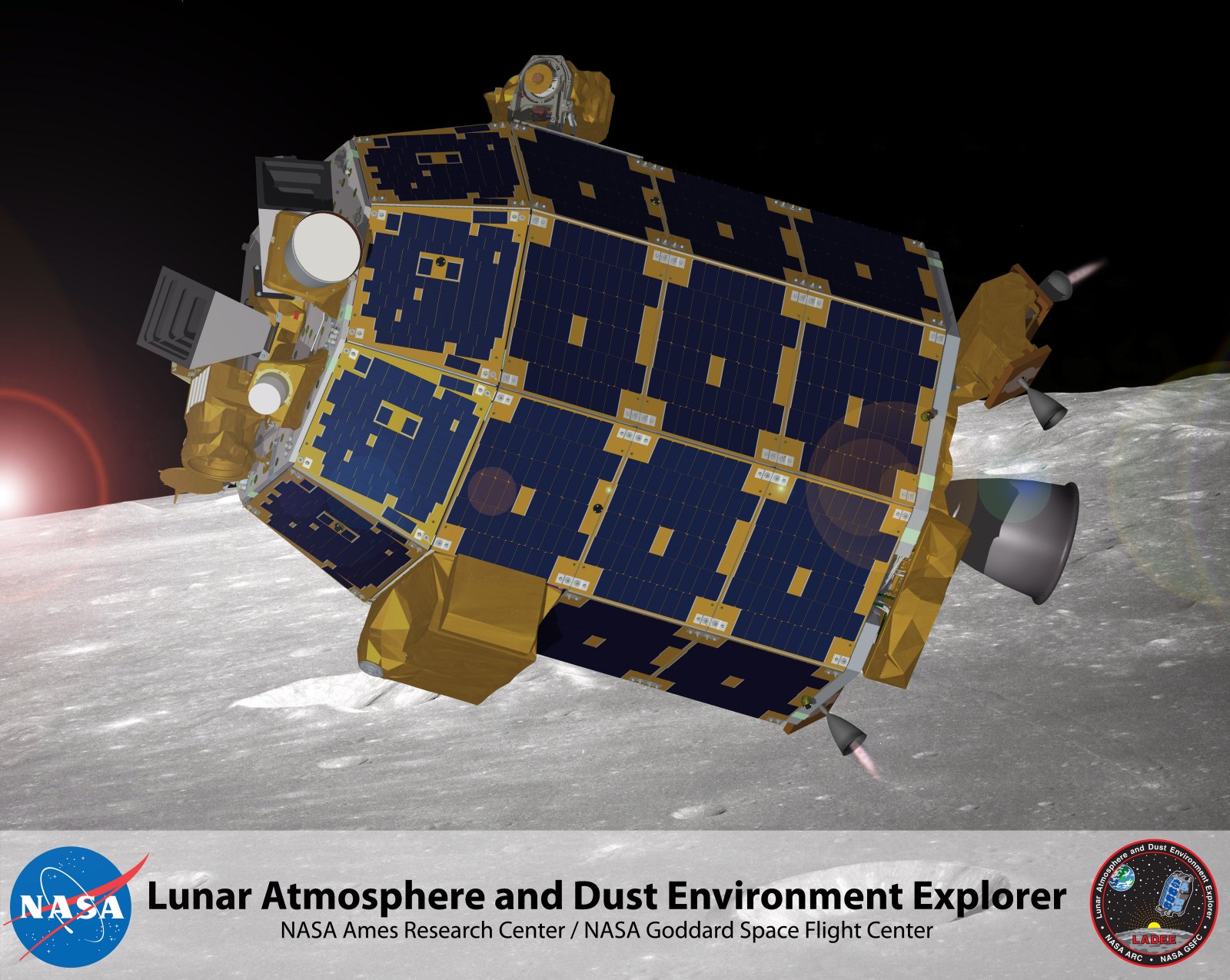
Idealized view of LADEE, last of the Constellation 'precursors,' in lunar orbit [NASA/ARC].
Steve Nerlich
AmericaSpace.com

The Lunar Atmosphere and Dust Environment Explorer (LADEE) is due for launch in September 2013 from the Mid-Atlantic Regional Spaceport. LADEE will study the composition and structure of the tenuous lunar atmosphere, including dust that may be lofted up from the surface. It will also undertake a demonstration of a laser-mediated communications system.

In a thick atmosphere like Earth’s, particles are constantly colliding with each other and hence moving in random and frequently-changing directions. The Moon is thought to have a surface boundary exosphere, which is a thin, collision-free atmosphere in which particles follow largely uninterrupted paths.

A key goal of the LADEE mission is to understand the dynamics of a surface boundary exosphere and how it changes over time, as external conditions vary. A surface boundary exosphere is probably the most common atmosphere found around celestial bodies in the Solar System, including Mercury, the majority of the large asteroids, the moons around our major planets, and the majority of large Kuiper Belt Objects. So, getting a better understanding of the Moon’s surface boundary exosphere is a good start to understanding those environments as well.

Indeed, there is a certain imperative to undertake this research now. The increasing interest in the Moon by a number of nations will lead to a steadily increasing frequency of lunar exploration missions that could change the natural composition of the lunar atmosphere, both through the stirring up of surface dust and by the addition of rocket exhaust components.

Read the article at AmericaSpace.com, HERE.

Related Posts:

Thursday, May 24, 2012

Re-release of Iconic Copernicus 'Image of the Century'

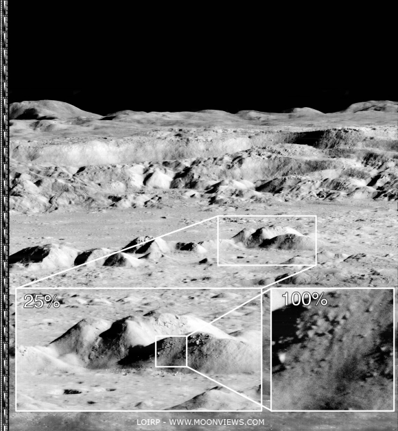
Newly processed high-resolution detail from an unprecedented oblique view of the interior of Copernicus captured by Lunar Orbiter 2, from the "Image of the Century" photographed November 24, 1966. Higher and full resolution images are linked to the Moonviews (LOIRP) announcement, HERE [LOIRP].
Keith Cowing
Lunar Orbiter Image Recovery Project
moonviews.com
NASAWatch.com


Today an iconic image from the initial exploration of the Moon is being re-released showing detail that could not have been seen using technology available at the time the photo was taken. This image features a dramatic view inside the majestic crater Copernicus - a view that left millions in awe when it was first released.

This image was announced at the First Global Space Exploration Conference, co-sponsored by the AIAA and IAF, in Washington, DC.

Between 1966 and 1967 NASA sent five Lunar Orbiter spacecraft to the Moon. Their job was to survey the surface to help determine landing sites for the upcoming Apollo missions. In addition to their recon role, these spacecraft also contributed to the nascent scientific understanding of the Moon. But every once in a while these spacecraft also served as artists, snapping photos of this nearby world in a way that human eyes had never been able to see before.

New magnification possible using the 21st century techniques employed by LOIRP. Higher and full resolution images are linked to the Moonviews (LOIRP) announcement, HERE [LOIRP].
Once such image was taken of crater Copernicus on 24 November 1966 by the Lunar Orbiter 2 spacecraft. What made this photo so unique was the oblique angle it was taken at as well the close proximity of the spacecraft to its target. The image was taken at an altitude of 45 km (27.1 miles) at a distance of approximately 207.7 km (~125 miles) from the center of the crater. Instead of looking down, the spacecraft looked sideways at the Moon.

The bouldered area of the central peaks of Copernicus seen newly sampled at "100 percent" in the image further up were swept up by the Lunar Reconnaissance Orbiter Camera in orbit 909, September 9, 2009; LROC Narrow Angle Camera (NAC) observation M107006443R; resolution 1.15 meters (shown here at 4 meters per pixel) from an altitude of 130.11 kilometers [NASA/GSFC/Arizona State University].
For the first time people saw the Moon as a world with mountains and boulders and other features (some of them strange) that were not apparent from photos where the view was looking straight down. So taken were people at the time that Life Magazine took to calling the photo "The Picture of the Century"

Read about the full details in the original article, HERE.

Monday, April 30, 2012

3rd Annual Next Generation Lunar Scientists and Engineers Workshop, July 16

The 3rd annual Next Generation Lunar Scientists & Engineers (NGLSE) Workshop will be held on Monday, July 16, 2012 at the NASA Ames Research Center (ARC), preceding the NASA Lunar Science Forum

This one-day workshop for graduate students and early career professionals offers the opportunity for participants to network with other students/early career professionals, and will specifically include a media training workshop. The purpose of this group is to engage and develop the next generation of lunar scientists and engineers, and to enable their successful involvement in current planning for the exploration of the Moon.

For more details, visit: http://nextgenlunar.arc.nasa.gov or email any questions to: Lora.V.Bleacher@nasa.gov

In addition, registration is now open for the 3nd Annual Lunar Graduate Conference (LunGradCon 2012) to be held on Saturday and Sunday, July 14-15, 2012, also at NASA ARC ahead of the NASA Lunar Science Forum.

LunGradCon provides an opportunity for grad students and early-career postdocs to present research on lunar science in a low-stress, friendly environment, being critiqued only by their peers. In addition to oral presentations, the conference presents opportunities for professional development and networking with fellow grad students and postdocs, as well as senior members of the NASA Lunar Science Institute.

For more details, please visit: http://lasp.colorado.edu/ccldas/lgc2012 or email any questions to: lungradcon@gmail.com  

Sunday, February 27, 2011

The Moon's metallic water


The LCROSS Shepherding Spacecraft Mid-Infrared Camera (MIR) captured this false-color image of the Centaur impact ejecta plume about 20 seconds after impact, October 9, 2009 [NASA/ARC/LCROSS].

Bill Steigerwald

NASA Goddard

Bring a filter if you plan on drinking water from the moon. Water ice recently discovered in dust at the bottom of a crater near the moon's south pole is accompanied by metallic elements like mercury, magnesium, calcium, and even a bit of silver. Now you can add sodium to the mix, according to Dr. Rosemary Killen of NASA's Goddard Space Flight Center in Greenbelt, Md.

Recent discoveries of significant deposits of water on the moon were surprising because our moon has had a tough life. Intense asteroid bombardments in its youth, coupled with its weak gravity and the Sun's powerful radiation, have left the moon with almost no atmosphere. This rendered the lunar surface barren and dry, compared to Earth.

However, due to the moon's orientation to the Sun, scientists theorized that deep craters at the lunar poles would be in permanent shadow and thus extremely cold, and able to trap volatile material like water as ice if such material were somehow transported there, perhaps by comet impacts or chemical reactions with hydrogen, a major component of the solar wind.

The October 9, 2009 impact of NASA's Lunar CRater Observation and Sensing Satellite (LCROSS) spacecraft into the permanently shadowed region of the Cabeus crater confirmed that a surprisingly large amount of water ice exists in this region, along with small amounts of many other elements, including metallic ones.

Read the full feature, HERE.

Wednesday, February 23, 2011

High-speed lunar navigation for crewed and remotely-piloted vehicles


Figure 2 - NASA’s K10 autonomous or teleoperated rover designed for robotic site survey, at speeds up to 0.6 m/s. (Houghton Crater K10 Field Test, 2010) [NASA/ARC/NLSI].

Pedersen & Allan, et al.
NASA Ames Research Center
Carnegie Mellon University
Humboldt University
ETH, Zurich


Increased navigation speed is desirable for lunar rovers, whether autonomous, crewed or remotely operated, but is hampered by the low gravity, high contrast lighting and rough terrain. We describe lidar based navigation system deployed on NASA’s K10 autonomous rover and to increase the terrain hazard situational awareness of the Lunar Electric Rover crew.

Introduction - High speed mobility (by planetary rover standards) is desirable for more efficient exploration of the lunar surface, particularly if human crews are present there.

NASA’s Lunar Electric Rover (LER) can drive at 10km/h (3m/s) on rough terrain, faster on known smooth surfaces. By comparison, the MER vehicles moves at a few cm/s while stopping regularly.

Driving on the Moon is complicated by the low gravity, rough terrain, high contrast lighting and alien environment.

Under the 1/6g lunar gravity a vehicle becomes airborne at relatively modest speeds (driving the Apollo era lunar rover at 7 mph was reportedly like being aboard a rowing boat for this reason). The reduced gravity also lessens vehicle-ground friction. Together these effects increase maneuvering distances.

Astronauts complained of difficulty discerning surface features on the Moon under certain lighting conditions, such as with the sun behind them. The lack of terrestrial depth cues compounds the difficulties of driving.

The 3 sec signal round trip time delay to the Moon permits tele-operating a vehicle from Earth (e.g. Lunakhod) with diffculty (increasing with speed).

This paper describes our robotic rover navigation systems, currently running on NASA’s autonomous or teleoperated K10 rover (Figure 2) and as a crew aid on the LER for increasing pilot situational awareness of the surrounding terrain. We address terrain sensing for 4 different classes of rovers: K10, the Lunar All Terrain Utility Vehicle (LATUV, Figure 3), the LER and the LER operating under lunar gravity and time-delayed tele-operation.

Subsequent sections describe the terrain mapping and hazard detection software, pose estimation, the rover software infrastructure for command and data handling, the graphical user interface and performance figures.

Read the Full Abstract, HERE


Figure 8 - Apollo 17 Station 3 high-resolution pan centered on the south rim of Ballet Crater; frames AS17-138-21155 through 21167 assembled by David Harland for the Apollo Surface Journal [NASA/JSC].

i-SAIRAS 2010. 10th International Symposium on Artificial Intelligence, Robotics and Automation in Space - Sapporo, Japan, August 29 - September 1, 2010

Tuesday, October 26, 2010

LRO-Diviner Lunar Radiometer observations of cold traps in the Moon’s south polar region

David A. Paige,1* Matthew A. Siegler,1 Jo Ann Zhang,1 Paul O. Hayne,1 Emily J. Foote,1 Kristen A. Bennett,1 Ashwin R. Vasavada,2 Benjamin T. Greenhagen,2 John T. Schofield,2 Daniel J. McCleese,2 Marc C. Foote,2 Eric DeJong,2 Bruce G. Bills,2 Wayne Hartford,2 Bruce C. Murray,3 Carlton C. Allen,4 Kelly Snook,5 Laurence A. Soderblom,6 Simon Calcutt,7 Fredric W. Taylor,7 Neil E. Bowles,7 Joshua L. Bandfield,8 Richard Elphic,9 Rebecca Ghent,10 Timothy D. Glotch,11 Michael B. Wyatt,12 Paul G. Lucey13
22 OCTOBER 2010 VOL 330 SCIENCE

Diviner Lunar Radiometer Experiment surface-temperature maps reveal the existence of widespread surface and near-surface cryogenic regions that extend beyond the boundaries of persistent shadow. The Lunar Crater Observation and Sensing Satellite (LCROSS) struck one of the coldest of these regions, where subsurface temperatures are estimated to be 38 kelvin. Large areas of the lunar polar regions are currently cold enough to cold-trap water ice as well as a range of both more volatile and less volatile species. The diverse mixture of water and high-volatility compounds detected in the LCROSS ejecta plume is strong evidence for the impact delivery and cold-trapping of volatiles derived from primitive outer solar system bodies.

The Moon’s polar regions are notable because of their potential to cryogenically trap water ice and other volatile species (1). The Lunar Reconnaissance Orbiter (2) (LRO) Diviner Lunar Radiometer Experiment has been mapping the infrared emission from the Moon since July 2009 using seven spectral channels that span a wavelength range from7.55 to 400 mmat a spatial resolution of ~200 m (3).

Thermal maps of the south polar region (Fig. 1, A and B) were obtained during the LRO monthly mapping cycle just before the Lunar Crater Observation and Sensing Satellite (LCROSS) impact (4), as the Moon approached southern summer solstice (5). The mapped quantity is the bolometric brightness temperature, which is the wavelength-integrated radiance in all seven Diviner channels expressed as the temperature of an equivalent blackbody (6). For quantifying the overall heat balance of the surface and comparing with available models, the bolometric brightness temperature is the most fundamental and interpretable measurable quantity.

For the simplest case in which Diviner’s surface footprint is filled with a blackbody of uniform surface temperature, the bolometric brightness temperature will be equal to the temperature of the surface.


Figure 1. Maps of measured and model-calculated surface and subsurface temperatures in the lunar south polar region. The outer circle on all maps is 80° south latitude. Observations were acquired between 6 September and 3 October 2009 as the Moon approached southern summer solstice. (A) Diviner-measured daytime bolometric brightness temperatures acquired between 11.4 and 13.6 hours local time (5). (B) Diviner-measured nighttime bolometric brightness temperatures acquired between 21.41 and 1.66 hours local time (5). (C) Model-calculated annual average near-surface temperatures and the location of the LCROSS impact in Cabeus Crater. (D) Model-calculated depths at which water ice would be lost to sublimation at a rate of less than 1 kg/m−2 per billion years. - The white regions define the locations where water ice can currently be cold trapped on the surface, the colored regions define the upper surface of the lunar ice permafrost boundary and the gray regions define locations where subsurface temperatures are too warm to permit the cold-trapping of water ice within 1 m of the surface.

In the more general case, where Diviner’s surface footprint contains small-scale slopes, shadows, or rocks, the brightness temperatures in Diviner’s individual infrared channels may vary with wavelength depending on the distribution of sub–footprint-scale temperatures, spectral emissivities, and photometric properties. In this case, the bolometric brightness temperature cannot be interpreted in terms of a unique surface temperature. However, within cold regions that are not in direct sunlight, simultaneously acquired brightness temperatures in Diviner channels 7 (25 to 41 mm), 8 (50 to 100 mm), and 9 (100 to 400 mm) are in good agreement (6), which is consistent with uniformly high spectral emissivity across this wavelength range and relatively uniform temperatures within each Diviner footprint (fig. S1, A and B). This interpretation is supported by the results of an analysis of data acquired in each of the Diviner infrared channels at the LCROSS impact site in Cabeus Crater (7). For unilluminated regions, we use Diviner bolometric brightness temperatures as reasonably accurate proxies for the temperature of the surface.

The thermal maps show that the coldest regions are located on the floors of larger impact craters that receive no direct sunlight (Fig. 1,A and B). For these regions, previous modeling studies have shown that the main heat source is emitted infrared radiation from distant interior sunlit crater walls (8–11). Topographic relief within cold crater floor regions can provide additional radiation shielding, resulting in intensely cold localized regions with measured mid-day bolometric brightness temperatures as low as 29 K. Heat flow fromthe lunar interior may contribute to the overall heat balance of these coldest surfaces, but is not dominant compared to heating from scattered solar and infrared radiation during this season (6). Diviner’s summer solstice observations represent a valuable snapshot of the south polar region surface temperatures that can be extended in depth and in time with models. We have developed a thermal model that realistically accounts for the effects of large-scale topographic relief on direct and indirect solar and infrared radiation on the heat balance of the lunar surface (6). The model uses a ~500-m-scale triangular mesh based on south polar topography derived from the Kaguya LALT laser altimeter (12) and a spatially uniform set of thermal and reflectance parameters that are generally consistent with those derived from previous studies (6). The excellent overall agreement between maps (fig. S3, A and B) and histograms (Fig. 2A) of the observed and calculated bolometric temperatures demonstrate the general validity of our modeling approach. The only notable discrepancy occurs for daytime temperatures in the shadowed portions of craters that have measured bolometric temperatures in the range of 60 to 120 K, where the model underestimates temperatures by roughly 15 K (fig. S4, A and B). This may be largely due to directionally anisotropic infrared emission from rough sunlit crater walls, which is not accounted for in the present model (6). Given the better agreement between the model and the Diviner nighttime data, we estimate that the net effect on model-calculated annual average temperatures at 2-cm depth (Figs. 1C and 2B) is less than 7 K in the warmest craters and close to zero in the coldest craters. For the limiting case of zero heat flow from the lunar interior, the temperatures at greater depths would be close to this near-surface average temperature (11). However, with nonzero heat flow, average temperatures will increase with depth at a rate proportional to the heat flow rate and inversely proportional to the thermal conductivity. Using parameters derived from the heat flow experiments at the Apollo 15 and 17 landing sites (13), we estimate that LCROSS impact site temperatures at 2-m depth should be <6 K higher than annual average surface temperatures (fig. S5). Although the Diviner bolometric temperatures presented here and cooling curves at the LCROSS impact site are generally consistent with the presence of unconsolidated regolith near the surface (7, 14), the thermophysical properties of the Moon’s cryogenic regolith are not currently well constrained and could differ substantially from those in warmer regions (15), particularly at depth.


Figure 2. (A) Normalized histograms of measured daytime and nighttime bolometric brightness temperatures for the maps shown in Fig. 1, A and B, with comparisons to model-calculated surface temperatures at the same locations and times as those of the Diviner observations (fig. S3, A and B). (B) Histograms of model-calculated annual average temperatures at 2-cm depth for the maps shown in Fig. 1C and fig. S7, A to D, and at the LCROSS impact site for selected values of qmax, the mean maximum angle between the Moon’s spin axis and the normal to the ecliptic plane. qmax =1.54° for present-day conditions. (C) The recent evolution of qmax as a function of the Earth-Moon distance (29). (D) The volatility temperatures of a range of potential cold-trapped volatile compounds (21, 22) View higher-resolution Fig. 2 HERE.

We expect that the Moon’s cryogenic regions extend to depths of at least tens of meters below the surface, but estimating the volumetric extent of the Moon’s cryogenic regions purely from surface-temperature observations is highly uncertain.

Thermal model results can be used to estimate the stability of water ice deposits to loss by sublimation and diffusive migration through the lunar regolith (11, 16). Figure 1D shows a map of the depths at which water ice would be lost at a rate of less than 1 kg m−2 per billion years, which corresponds to a loss rate of 1 mm per billion years for a pure ice deposit (6). The results show that surface cold traps for water ice are surrounded by much more extensive “lunar permafrost” regions where water ice is stable in close proximity to the surface (17). These regions may receive direct solar radiation during periods when solar lighting conditions are most favorable, but maintain annual maximum temperatures at depth that are sufficiently cold to effectively prevent appreciable water loss due to sublimation. Because of their more hospitable surface thermal and illumination environments, lunar permafrost regions may be accessible locations for future in situ exploration of the Moon’s cold traps.

The overall picture painted by the present thermal state of the lunar south polar region is one of extreme cold. Temperatures in the Moon’s larger cold traps are closer to those expected for the poles of Pluto (18) than for Earth’s closest neighbor. At the cold temperatures that exist within most south polar craters, cold-trapped water molecules have negligible mobility (16), such that any water molecules deposited on the surface will not effectively diffuse below the surface where they can be protected from loss processes such as photolysis and sputtering (19). In cryogenic regions, burial of frozen volatiles by impact gardening is likely to be a much more effective process (20). However, warmer permafrost regions that currently exist at the margins of cold traps may represent somewhat more favorable environments for the downward diffusion of water molecules into the regolith, which should be aided by the daytime temperature gradient between warmer surface layers and colder subsurface layers below.

The distribution of temperatures in the lunar south polar region also places constraints on the thermal stability of non-water volatile species. Figure 2D shows the volatility temperatures (the temperatures at which pure solids exposed to vacuum at the surface would sublimate at a rate of 1 mm per billion years) for several volatile species (21, 22). Non-water subsurface volatiles will also be stable to sublimation at higher temperatures owing to the effects of diffusive migration through the regolith (6). Large areas of the lunar south polar region have the capability to cold-trap water and less volatile species such as mercury and sodium. All three of these volatile species were in the LCROSS ejecta plume (4, 14, 23).

Colder surface and subsurface areas in the south polar region also have the capability to cold-trap so-called super volatile species that have higher volatility than water, which include compounds such as sulfur dioxide, carbon dioxide, formaldehyde, ammonia, and methanol. The detection of a representative cross-section of these same supervolatile species in the LCROSS ejecta plume (4) represents strong evidence for the impact delivery of volatiles to the Moon by primitive outer solar system bodies, and the subsequent cold-trapping of these volatiles at the lunar poles (21, 22).

A question of interest regarding the lunar cold traps is whether they contain abundant deposits of nearly pure water ice such as those discovered by radar observations of impact craters at the poles of Mercury (24). Diviner-measured summer solstice daytime and nighttime surface bolometric brightness temperatures of 46.7 and 38.7 K in the region surrounding the LCROSS impact site, and model-calculated annual average temperatures at this site at a depth of 2 cm, are close to 38 K (6). As shown in Figs. 1, C and D, and 2B, the LCROSS impact site is a surface cold trap for water and is among the coldest locations in the south polar region. The Lunar Prospector Neutron Spectrometer (LPNS) results show that the average hydrogen abundance in the near-surface regolith at the south pole is ~70 parts per million (ppm) by weight, which translates to a water-equivalent average abundance of ~600 ppm by weight (25). Our results show that the surface and near-surface water ice cold traps comprise >66% of the surface area poleward of 85° south latitude (Fig. 1D). If we assume that all the hydrogen detected by LPNS was uniformly distributed within these cold traps, then the average water-equivalent abundance would be only ~1000 ppm by weight, which is substantially less than the 1 to 10% water content inferred at the LCROSS impact site (4). This suggests that the LCROSS site must be enriched in water compared to the average south polar near-surface cold trap, which is consistent with enhanced hydrogen abundances observed in the Cabeus region by orbital neutron spectrometers (26–28).

The spin pole of the Moon is currently in a tidally damped Cassini State 2 configuration in which the time-averaged maximum angle between theMoon’s spin axis and the normal to the ecliptic plane (qmax) has decreased to its present value of qmax = 1.54° as the Earth-Moon distance increased over time (Fig. 2C) (29). The absolute time scale for the tidal evolution of the Earth-Moon system is highly uncertain, but it is likely that the transition depicted in Fig. 2C has occurred over a period of more than 1 billion years (30). Model-calculated annual average near-surface temperatures qmax = 4°, 8°, 12°, and 16° (Fig. 2B and fig. S7, A to D) show that portions of the Moon’s south polar region cooled considerably as the Moon’s orbital radius increased, first creating cold traps capable of cold-trapping water, and then trapping compounds with higher volatility. The LCROSS impact site,which is located on the floor of the large Cabeus impact crater, is typical of the coldest areas on the Moon today. However, earlier in the Moon’s orbital history, when qmax was greater than ~10°, the floors of large-impact craters were not the coldest areas on the Moon because the walls of these relatively shallow craters did not shield their floors from direct solar radiation. Based on the results in Fig. 2B and fig. S7, A to D, the Moon’s earliest surviving near-surface cold traps are not located on the floors of large-impact craters, but rather on the floors of intermediate-sized craters, which thus may have had longer opportunities to accumulate water ice.

1Department of Earth and Space Sciences, University of California, Los Angeles, 595 Charles E. Young Drive East, Los Angeles, CA 90095, USA. 2Jet Propulsion Laboratory, California Institute of Technology, Pasadena, CA 91109, USA. 3California Institute of Technology, Pasadena, CA 90025, USA. 4NASA Johnson Space Center, Houston, TX 77058, USA. 5NASA Goddard Space Flight Center, Greenbelt, MD 20771, USA. 6U.S. Geological Survey, Flagstaff, AZ 86001, USA. 7Oxford University, Oxford OX1 3PU, UK. 8University of Washington, Seattle, WA 98195, USA. 9NASA Ames Research Center, Moffett Field, CA 94035, USA. 10University of Toronto, Toronto, ON M5S 3B1, Canada. 11State University of New York, Stony Brook, NY 11794, USA. 12Brown University, Providence, RI 02912, USA. 13University of Hawaii, Honolulu, HI 96822, USA.

*To whom correspondence should be addressed. E-mail: dap@moon.ucla.edu

References and Notes:

1. K. Watson, B. C. Murray, H. Brown, J. Geophys. Res. 66, 3033 (1961).
2. G. Chin et al., Space Sci. Rev. 129, 391 (2007).
3. D. A. Paige et al., Space Sci. Rev. 150, 125 (2010).
4. A. Colaprete et al., Science 330, 463 (2010).
5. The LRO orbit plane is inclined 90° to the lunar equator and is fixed in inertial space. LRO’s ground track rotates through 360° of longitude every sidereal month, allowing Diviner to make one daytime and one nighttime map every 27.3-day mapping cycle in pushbroom nadir mapping mode. Local time on the Moon can be expressed in hours by normalizing the angular distance between geographic longitude and the longitude of the solar point to a 24-hour day. We define daytime to be between 6 a.m. and 6 p.m. local time, and nighttime to be between 6 p.m. and 6 a.m. local time. Because the plane of the LRO orbit rotates relative to the lunar terminator by 360° every Earth year, the local times of Diviner’s observations drift by ~2 hours during each mapping cycle. The subsolar latitude on the Moon currently varies by approximately T1.54° over the course of the Moon’s 346-day draconic year, resulting in distinct seasonal temperature variations at the highest latitudes. The LRO launch date was chosen so that the LRO orbit plane was within 10° of the noon-midnight plane during LRO’s first southern summer solstice.
6. Supporting material is available on Science Online.
7. P. O. Hayne et al., Science 330, 477 (2010).
8. R. R. Hodges, Lunar Planet Sci. Conf. 11, 2463 (1980).
9. D. A. Paige, S. E. Wood, A. R. Vasavada, Science 258, 643 (1992).
10. A. P. Ingersoll et al., Icarus 100, 40 (1992).
11. A. R. Vasavada et al., Icarus 141, 179 (1999).
12. H. Araki et al., Science 323, 897 (2009).
13. M. G. Langseth et al., Proc. Lunar Sci. Conf. 7, 3143 (1976).
14. P. H. Schultz et al., Science 330, 468 (2010).
15. G. J. Taylor et al., Proceedings of Space Resources Roundtable VI. LPI Contribution No. 1224., Golden, CO, Abstract 6040 (Lunar and Planetary Institute, Houston, TX, 2004).
16. N. Schorghofer, G. J. Taylor, J. Geophys. Res. 112, E02010 (2007).
17. We estimate that the total area of surface water ice cold traps in the lunar south polar region shown in Fig. 1D is 13,087 km2, and the total area of near-surface water ice cold traps to a depth of 1 m is 119,507 km2.
18. C. J. Hansen, D. A. Paige, Icarus 120, 247 (1996).
19. T. H. Morgan, D. E. Shemansky, J. Geophys. Res. 96 (A2), 1351 (1991).
20. D. H. Crider, R. R. Vonrak, Adv. Space Res. 31, 2293 (2003).
21. J. A. Zhang, D. A. Paige, Geophys. Res. Lett. 36, L16203 (2009).
22. J. A. Zhang, D. A. Paige, Geophys. Res. Lett. 37, L03203 (2010).
23. G. R. Gladstone, Science 330, 472 (2010).
24. J. K. Harmon, Space Sci. Rev. 132, 307 (2007).
25. W. C. Feldman et al., J. Geophys. Res. 106 (E10), 23,231 (2001).
26. D. J. Lawrence et al., J. Geophys. Res. 111, E08001 (2006).
27. R. C. Elphic et al., Geophys. Res. Lett. 34, L13204 (2007).
28. I. Mitrofanov et al., Lunar Planet. Sci. Conf. 41, 2250 (2010).
29. W. R. Ward, Science 189, 377 (1975).
30. B. G. Bills, R. D. Ray, Geophys. Res. Lett. 26, 3045 (1999).
31. We thank the many people at the Jet Propulsion Laboratory and the Goddard Space Flight Center who contributed to the success of the Diviner instrument and the LRO project. We also thank the National Aeronautics and Space Administration for funding this investigation.

Supporting Online Material
www.sciencemag.org/cgi/content/full/330/6003/479/DC1
Methods Figs. S1 to S7
References 1 February 2010; accepted 12 August 2010 10.1126/science.1187726

Tuesday, August 17, 2010

LCROSS flight operations report


Impact Science Observations. The above diagram is a timeline of instrument data collection covering the five minutes prior to the impact of the LCROSS Shepherding Spacecraft. Label `A” shows downlink fully subscribed; `B” shows irregular ticks that reflect images dropped onboard because of downlink "over-subscription;" `C” shows the effect of a ground command sent to reduce camera sampling rates; `D” shows how a command sent to change an image exposure setting enabled imaging the Centaur crater in near-infrared (NIR).

The left image is the near-infrared spectrometers field-of-view just after the Centaur impact.

Paul D. Tompkins, et.al.
Stinger Ghaffarian Technologies
LCROSS Lead Flight Director, ARC


LCROSS (Lunar CRater Observation and Sensing Satellite) was conceived as a low-cost means of determining the nature of hydrogen detected at the polar regions of the moon. The mission presented several inherent challenges – planning for and achieving a precise impact at a lunar pole, guiding a Centaur upper stage far beyond its operational lifetime, co-launching as a secondary payload with the LRO spacecraft, and preparing for and operating such a mission under a highly constrained budget and short development cycle. Beyond these, the flight itself presented other hurdles in the path to success, including several anomalies, one of which was nearly mission-catastrophic.

Section I (of the AIAA report) provides the reader with background on the LCROSS project and components. Section II provides an overview of the flight mission. The remaining sections describe specific challenges encountered in planning and executing the mission and how they were overcome. The paper concludes by highlighting the key factors for the mission’s success.

Managed, partially developed, and operated from NASA Ames Research Center (ARC), LCROSS was selected under the Exploration Systems Mission Directorate’s (ESMD’s) Lunar Precursor Robotic Program (LPRP) as a secondary payload manifested with the Lunar Reconnaissance Orbiter (LRO), under a $79 million cost cap.

LCROSS was designated as a Class D mission, indicating NASA’s willingness to accept greater levels of programmatic and operational risk. Rather than incur the high cost and mission complexity associated with landing at a lunar pole, LCROSS precisely guided its Centaur Earth Departure Upper Stage (EDUS) to a lunar target as a kinetic impactor to raise a plume of polar regolith from the surface. After releasing the Centaur, the guiding Shepherding Spacecraft (S-S/C) employed a suite of nine science instruments to analyze the impact flash and plume materials at close range. Earthbased and orbiting assets, including LRO and the Hubble Space Telescope, acted in a supporting role for impact observations.

The LCROSS project remained on-budget and on-schedule, despite many programmatic and technical challenges. LCROSS launched with LRO on June 18, 2009, and on October 9, 2009, after 112 days in flight, the LCROSS team successfully delivered both the Centaur and S-S/C on-target within Cabeus crater and collected extensive data from all instruments during and after the Centaur impact.

After one month of post-impact analysis, the LCROSS science team announced the positive identification of water on the floor of Cabeus.

The LCROSS mission was faced with many challenges. Late-breaking predictions of possible Centaur gas leaks forced the operations team to revise or newly develop and test broad-reaching procedures and command sequences in the weeks prior to launch. Strict impact targeting precision requirements were made more challenging under the many perturbations to the LCROSS orbit, including from the spacecraft’s own (attitude control) thruster firings and volatiles escaping from the ice-laden Centaur exterior. LCROSS experienced two challenges to propellant reserves - a persistent Centaur gas leak and a propellant-intensive response to a very brief IRU fault. The LCROSS mission operations team, only barely large enough to staff the busy first week of flight, was taxed further by a series of anomalies that, while recoverable, stretched working hours well beyond original expectations.

Read the report (pdf), HERE.
SpaceOps 2010
Huntsville, 25-30 April 2010

Tuesday, August 3, 2010

Interview with new NLSI head Yvonne Pendleton

"The moon has gone from questionably interesting to absolutely fascinating. It’s providing a laboratory, our nearest laboratory off-planet where we can go and actually explore and test."

Last month Dr. Yvonne Pendleton became director of NASA’s Lunar Science Institute at Ames Research Center in California.

"Because of the missions that have happened recently, especially LRO, the Lunar Reconnaissance Orbiter , and LCROSS, the mission that impacted the moon and kicked up material that we are now analyzing, we’re understanding far more about the water and volatile materials on the moon. In many respects, the moon represents our history, our past, and also our future."

90 Second Interview:


Full 8 minute Audio & Text Summary @ Earthsky


Sunday, August 1, 2010

You decide the Desert RATS' next destination


SEV - Surface Exploration Vehicle (Surface Concept) at Desert RATS Field Test on the Black Point Lava Flow in Arizona. Unveiled in 2007, the latest model began tests in 2009. During the Apollo program, exploration was confined to the distance astronauts could expect to walk back wearing spacesuits if their rovers broke down: about 10 km. The presence of two or more service SEVs on the lunar or Martian surface would extend that potential range to more than 200 km in any direction, greatly increasing the scientific opportunities during missions. Even in the midst of challenging terrain, emergency shelter and support can be less than an hour away. [NASA/ARC/IRG].

NASA is inviting the public to choose the area in northern Arizona where explorers will conduct part of the annual Desert Research and Technology Studies (Desert RATS).

"Desert RATS is an annual test where NASA takes equipment and crews into the field to simulate future planetary exploration missions," said Joe Kosmo, Desert RATS manager at NASA's Johnson Space Center in Houston. "We want the public to be a part of this."

From July 27 until August 8 anyone can vote on where to send the Desert RATS team. To cast your vote, visit HERE.

(http://ti.arc.nasa.gov/desertrats/vote).

The website features interactive panoramic images of lava, rocks and desert for the public to choose as the most interesting destination to explore.

The location that receives the most votes will be announced August 16. Astronauts will visit that site to perform field geology and collect rock samples.

The Intelligent Robotics Group (IRG) at NASA/Ames Research Center (Moffett Field, CA) took the panoramic images of terrain and geologic features at Black Point Lava Flow in Arizona.

"It is essential to involve the public in NASA's exploration program to engage and inspire the next generation of scientists and engineers," said IRG Director Terry Fong. "We want people of all ages to be able to actively participate, contribute and collaborate in meaningful ways to NASA's activities."

The Desert Rats 2010 mission also involves field testing two space exploration vehicles, which could allow astronauts to spend two or more weeks living, working, and traveling across different planets. Astronauts will use two such vehicles to explore a lava flow and test data collection methods, communications protocols, mission operations, and advanced technology. Desert RATS is sponsored by NASA's Exploration Systems Mission Directorate in Washington.


A Glimpse of the Future - Micro-Gravity airless-body exploration will require a play on the SEV without wheels. The Surface Exploration Vehicle (Space Concept) features aspects also undergoing tests [NASA/ARC].