Showing posts with label Highlands. Show all posts

Thursday, January 10, 2013

Offset crater, active Moon

A small offset crater in the near side southern highlands. Field of view 342 meters across, from LROC NAC frame M177562995R, LRO orbit 11202, December 3, 2011; angle of incidence 72.25° from 39.76 km [NASA/GSFC/Arizona State University].
Renee French
LROC News System

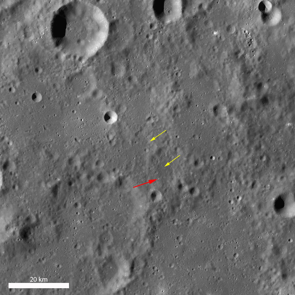
Today's image is of a 100 meter diameter crater (29.814°S, 11.465°E) located in highland terrain between Tycho crater and Nectaris basin. However, it doesn't look like a normal bowl-shaped crater by any stretch of the imagination! The top half looks like it has been shifted to the right relative to the bottom half, which is consistent with motion along a right-lateral strike-slip fault. Likely this odd crater was cut by a fault associated with the nearby Poisson lobate scarp. The faulting helps us determine the relative age of local features. The crater on the right does not appear offset, so that tells us that the fault was active after the crater on the left formed (thus offsetting it) but was not active since the formation of the crater on the right! This relationship also indicates that the crater on the left is older than the crater on the right. Observations like these allow scientists to assign relative ages to features on the surface; the only way to accurately determine absolute ages for features this small is to bring back samples for radiometric age dating. If you were to look at this crater using WAC data (see below), you couldn't tell that it was offset by a fault but you could spot it due to its high reflectivity. High resolution NAC images like these have shown that there is relatively recent, small-scale tectonic activity and that the Moon is far from being geologically dead!

LROC Wide Angle Camera (WAC) 100 meter monochrome mosaic. Red arrow points to the featured offset crater, a bright spot at this resolution and the yellow arrows point to the Poisson lobate scarp [NASA/GSFC/Arizona State University].
Check out the full LROC NAC image to spot other faulting, HERE.

Related Posts:
Relative age relationships
Scarps in Schrödinger
The Ghosts of Mare Fecunditatis

Friday, January 4, 2013

Tres Amicis

Three similar and relatively small impact craters (125-180 meters in diameter) in the nearside southern highlands may have formed in a contemporaneous impact event. LROC Narrow Angle Camera (NAC) observation M106827539L, LRO orbit 884, September 5, 2009; angle of incidence 27.64° at 1.09 meters resolution; field of view 995 meters wide, from 106.57 km [NASA/GSFC/Arizona State University].

Jeffrey Plescia
LROC News System

These three craters, located at 9.665°S, 7.646°E, appear to have formed more or less at the same time, certainly within a few minutes of each other. The southwest crater is 180 m diameter; the center crater is 150 m; and the northeast crater is 125 m across. 

From the northeast crater center to the southwest crater centers, they cover about 450 m. 

The projectiles were traveling from the east-northeast (the right side of the frame) and probably struck the surface at a relatively low angle, as indicated by the asymmetric ejecta patterns and the orientation of the ejecta rays. Bright ejecta extends as much as 1 km from the crater center.

Zoomed out view to include a larger area around the craters so that the long, thin bright ejecta rays are visible. Note that the ejecta is directed to the west (left side); little of it has gone to the east (right). NAC image M106827539L [NASA/GSFC/Arizona State University].
The morphology of the craters suggests that the southwest crater formed first, followed by the other two. The southwest crater may only have formed a few seconds or a few minutes before the other two; the timing is indicated by the ejecta from the middle crater that partly covers the southwest crater. The morphology of the two northeast craters (the low northwest-trending ridge between the craters) suggests that the projectiles hit the surface at the same time such that the excavation process of the two craters interacted, forming the ridge.

Same scene as above in afternoon lighting (angle of incidence 79.38°). The low Sun accentuates the subtle topography associated with the impact craters. LROC NAC observation M102107709R, spacecraft orbit 225, July 13, 2009; field of view 711 meters at 1.01 meters resolution from 98.73km [NASA/GSFC/Arizona State University].
This same crater morphology was created in laboratory experiments where multiple projectiles were simultaneously fired from a high velocity gun. One of the distinctive features of the simultaneous impact is the presence of a ridge (or septum) of material between the craters.

Experimental double simultaneous impact crater in the Ames Vertical Gun, from Oberbeck et al. (1972) Apollo 16 Preliminary Science Report, Fig 29-71, "Impact Craters Produced Simultaneously" [NASA/ALSJ].
Explore the entire LROC NAC frame, HERE.

Related Images:

Tuesday, October 9, 2012

Dynamics of Molten Rocks

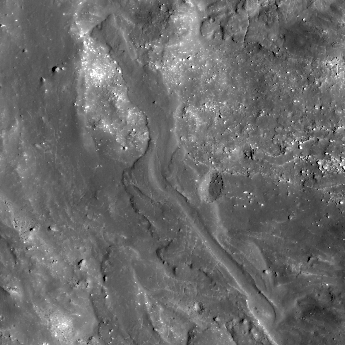
A portion of the impact melt near the western rim of Mandel'shtam F crater. Image centered near 5.130ºN, 165.822ºE, field of view width is 1182 meters. LROC Narrow Angle Camera (NAC) observation M189515239R , LRO orbit 12981, April 19, 2012; angle of incidence 31.98, full resolution 0.98 meters, from 120.3 km [NASA/GSFC/Arizona State University].
Hiroyuki Sato
LROC News System

Mandel'shtam F is a 15 km diameter crater located in the farside highlands. Along the western rim of this crater are several impact melt deposits formed from material splashed out of the crater cavity. The opening image highlights one such impact melt that flowed down the crater flank about 1.7 km.

Typically these impact melt-flow deposits are characterized with a meandering path, bifurcated distal edges, inflated relief, and levees. They resemble lava flows found in Hawaii or Iceland, but the generation process is completely different. The instantaneously-formed molten rocks from the anorthosite rich highland materials had cooled as they flowed downhill (and the melt viscosity increased). New NAC topographic and images acquired by LROC NAC enable us to examine the dynamics of these molten rocks (Denevi et al., 2012).

Mandel'shtam F crater and surrounding area in LROC WAC monochrome mosaic (100 m/pix). Image center is 5.07ºN, 166.00ºE. Blue box and yellow arrow indicate the locations of NAC footprint and today's Featured Image respectively [NASA/GSFC/Arizona State University].

Explore the impact melt flows at Mandel'shtam F in full NAC image yourself, HERE.

Related Posts:
La Pérouse A Impact Melt
Impact Melt Fingers
Impact Melt Lobes
Rootless impact melt flows
Look at that flow!
Out of the Shadows: Impact Melt Flow at Byrgius A Crater

Wednesday, September 19, 2012

La Pérouse A Impact Melt

Solidified impact melt flows outside the crater La Pérouse A. Another crop from LROC Narrow Angle Camera (NAC) frame M152390311R, spacecraft orbit 7591, February 15, 2011; 51 cm resolution from 46.56 km,  image width 705 meters [NASA/GSFC/Arizona State University].
Sarah Braden
LROC News System

Today's Featured Image shows impact melt flows near the outer rim of the crater La Pérouse A (4.08 km in diameter, 9.268°S, 74.705°E). Distinct channels and flow lobes are visible within this area. Small channels and levees are visible along the edges of some of the individual flows. As the melt moved farther away from the crater rim (the crater rim is toward the top of the image), the melt cooled. At the end of each flow lies a deposit of impact melt material. More impact melt may have been emplaced around the rim of the crater, but the landslide of highland material could have destroyed it.

The crater La Pérouse A is a very young satellite crater of the larger (80.4 km diameter) La Pérouse crater group, named after the French explorer Jean Francois de Galoup, known as Comte De La Pérouse. The Comte De La Pérouse sent his expedition journals and charts back to Europe shortly before he and his expedition disappeared. If he hadn't sent this information back, he probably wouldn't have a lunar crater named after him, since later on the shipwrecks of his two boats were found in Oceania.

For context, the impact melt field in the LROC Featured Image on the southern flank of La Pérouse A is shown in the full width of LROC NAC frame M152390311R [NASA/GSFC/Arizona State University].
The footprint of LROC NAC frame M152390311R rendered on the lunar framework of Google Earth as a demonstration of the bright and extensive albedo of La Pérouse A making the crater quite visible out of proportion with its relatively small size [Google/NASA/JAXA/GSFC/USGS/Arizona State University].
WAC context image (75 km across) of La Pérouse A and its high reflectance ejecta blanket, which indicates a relatively young age [NASA/GSFC/Arizona State University].

Explore the entire NAC frame, HERE.

Related Images:
River of Rock
Lichtenberg B Flow
Rootless impact melt flows
Lopsided La Pérouse A

Thursday, July 12, 2012

LROC: Simpelius Scarp

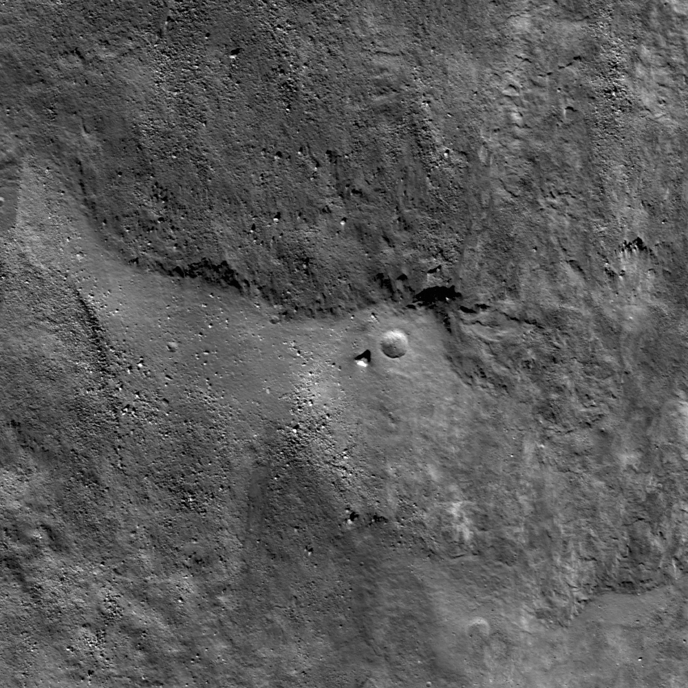
A lobate scarp formed in the far south nearside lunar highlands. Lunar scientists keep finding more of these tectonic features as LROC Narrow Angle Camera (NAC) high-resolution image coverage of the lunar surface continues to grow. An image from the Commissioning phase of the LRO mission, LROC NAC observation M106807247L, orbit 886, September 5, 2009; field of view is approximately 1000 meters wide, a 74.06° illumination incidence angle at 1 meter resolution from 42.59 km [NASA/GSFC/Arizona State University].
Drew Enns
LROC News System
 

Lobate scarps are, along with wrinkle ridges, one of the major contractional features found on the Moon. Though unlike wrinkle ridges, lunar lobate scarps form (almost) exclusively in the lunar highlands. This lobate scarp, designated Simpelius scarp, is located far to the south at 73.609°S, 8.764°E.

Unlike lobate scarps on other planets, the lunar scarps are fairly small with <100 meters maximum relief.

So how do such small features survive the onslaught of small impactors over time?

LROC QuickMap 64 meter resolution context for the Simpelius Scarp, located above the business end of the yellow arrow. At this scale and smaller the scarp is difficult to spot because it's small. [NASA/GSFC/Arizona State University].

The sharp features, lack of larger superposed craters, and cross-cutting relationship with small craters all imply that Simpelius scarp is young. The most compelling evidence that it is very young is simply that it exists at all. After about 100 million years the Moon's surface is saturated (every square inch of the surface has been reset with a crater of this size) with 100 meter diameter craters.

And the scarp is invisible altogether in this LROC QuickMap 1000 meter field of view covering the central meridian lunar surface south from 60°S to just beyond the ancient rim of South Pole-Aitken basin to Shackleton, host to the Moon's South Pole [NASA/GSFC/Arizona State University].
Since we can find only a very few craters of this size, the scarp must be significantly younger than that saturation age. If so, the Moon must have undergone compression recently, since lobate scarps are found everywhere on the Moon, and scientists are fairly certain that the Moon is still shrinking as its molten core continues to solidify and shrink. The crust is rigid and suffers brittle fracture, due to the shrinkage, that results in lobate scarp formation. Yes, the Moon is an active place just waiting for a network of seismometers to probe its interior!

Explore more of the lobate scarp in the full LROC NAC, HERE.

Related Posts:
Not Your Average Scarp
Tectonics in Mare Frigoris
Lobate Scarp or Fluidized Ejecta

Wednesday, June 13, 2012

Second Conference on the Lunar Highlands

First Results: from Figure 2, "Preliminary results on the structure of lunar highland crust from GRAIL and LOLA altimetry," Zuber & Smith, et al, (#9015, Second Conference on the Lunar Highlands Crust, 2012) Preliminary GRAIL gravity field for the 86-km-diameter Tycho crater. Tycho is the prominent structure at upper left. In this GRAIL map reds correspond to mass excesses and blues to mass deficits. GRAIL gravity has a spatial resolution of 18 kilometers [NASA/JPL/MIT].
Clive Neal
Notre Dame

The first conference on the Lunar Highlands Crust was held in 1979. Since that seminal meeting, our knowledge of the lunar highlands has advanced enormously. Unimagined new data have become available, notably in orbital remote sensing of mineralogy, chemistry, topography, and gravity; geochronology; and geochemistry, especially isotopic constraints and the abundances and natures of lunar volatiles. These new data are paralleled by new concepts of solar system science, including the importance and timing of impact events (including the one that formed the Moon) and the nature of the early solar system disk and its dynamical instabilities. 

In light of these advances in the last 34 years, the time seems right for a synoptic reexamination of the lunar highlands crust. The Second Conference on the Lunar Highlands Crust is intended to bring members of the planetary science community together to share their specialized insights into the lunar highlands crust, exchange ideas freely, and perhaps develop new cross-disciplinary ideas and tests of those ideas.

A field trip to the Stillwater Mine will be held on Thursday, July 12, and a field trip to Picket Pin Mountain will be held on Monday, July 16 (departing Bozemanon Sunday, July 15, following the conclusion of the final oral session). More details about the field trips, along with information about registration, accommodations, transportation, and much more, are available in the final announcement.

For more information, visit the conference website, HERE.

"Preliminary results on the structure of lunar highland crust from GRAIL and LOLA altimetry," Zuber & Smith, et al, (#9015, Second Conference on the Lunar Highlands Crust, 2012)

Related: Lunar Picture of the Day (LPOD), "First Results," June 13, 2012, Charles Wood

Thursday, May 3, 2012

LROC: Melt on a Rim

Impact melt started to flow back into the crater cavity before it solidified. 500 meter field of view on a crater rim near 38.053°N, 53.035°E in the nearside highlands - LROC Narrow Angle Camera (NAC) observation M170205366L, LRO orbit 10217, September 9, 2011; incidence 41.9° at 0.48 meters resolution, from 40.32 kilometers. View the full size LROC Featured Image HERE [NASA/GSFC/Arizona State University].
Lillian Ostrach
LROC News System

So much energy is released when an asteroid or comet slams into the Moon that some of target rock (the Moon) is melted. For large craters, such as Tycho or Copernicus, the impact event responsible for forming these craters was large enough to generate melt that coated and covered the crater floor, and ejected melt pooled and flowed outside the crater cavity. Tycho and Copernicus are typical examples of amazing impact melt deposits, but LROC NAC images show that impact melt is widespread and quite common to lunar impact craters. But don't be fooled into thinking that impact melt will be found only on the crater floor and in impact melt ponds exterior to the crater just because of the Tycho and Copernicus examples - the impact process is dynamic, so surveying the entire crater for the presence of impact melt is a must. In fact, channels, flows, and veneers are often found in NAC images.

LROC QuickMap NAC/WAC mosaic shows the general field of view within the LROC Featured Image released May 3, 2012 backed up to 4 meters resolution [NASA/GSFC/Arizona State University].
Today's Featured Image is one such example, where an unnamed ~4.2 km diameter crater located in the nearside highlands (38.112°N, 53.052°E; northeast of Mare Tranquillitatis) is heavily veneered with impact melt. Taking a look at the southern crater rim, although portions of the crater wall are disaggregating into bouldery, granular materials through erosional processes, much of the wall is smoothed with an impact melt veneer. Additionally, there is an area of very smooth impact melt with a rounded, lobate boundary reminiscent of flow. Shadows suggest that this flow-like feature may have some topographic relief and is probably not simply a thin layer of impact melt covering the crater wall material. These observations provide evidence for impact melt flow from the crater rim back into the crater, sometimes called flowback. How might this feature have formed? When impact melt is ejected from the crater during the last stages of crater formation, its landing place is determined by the energy remaining from the impact event. If there is substantial energy remaining, the melt will probably be ejected to the crater exterior and may form ponds, flows, and veneers. But if there is not quite enough energy to push the melt beyond the crater rim, the melt may land at or near the rim, and then gravity takes over. If enough melt is emplaced at the rim and it is hot enough to flow, the melt may coalesce and begin to flow downhill, perhaps forming a morphology similar to the one observed in the opening image.

LROC WAC monochrome mosaic centered on the unnamed impact crater coincident with Berzelius W. Asterisk notes location of the field of view highlighted in the LROC Featured Image released May 3, 2012, unnamed impact crater is ~4.2 km across [NASA/GSFC/Arizona State University].

Of note is a 20 m diameter impact crater near the edge of the flow lobe because the morphology of the crater suggests that it may have formed while the melt was at least partially molten. The crater has relatively smoothed and softened morphology and lacks an ejecta blanket. When impacts into solid target rock occur, the excavated material is blocky. While it is possible that there is now a very thin layer of regolith overlying the impact melt (because the parent crater is geologically young), a crater of this size would have punched through the thin regolith to expose the solid rock beneath. Now, the impact occurred on a slope, so one could argue that the ejected material rolled downhill. However, this hypothesis does not fully explain the rounded, degraded lower portion of the crater rim, which is smooth and mostly block-free, and also does not explain the absence of a well-developed ejecta blanket. So, based on the available data and observations, the explanation of crater formation while the melt was still partially molten is consistent with the observations, but additional observations, such as studying the morphology of other craters that formed in impact melt deposits, would be useful to definitively determine when this small impact crater formed.

Discover the impact melt veneers, flows, and channels for yourself in the full LROC NAC frame, HERE.

Related Posts:
Lichtenberg B Flow
Outside of Giordano Bruno
On the Floor of Thales

Friday, March 23, 2012

The first student-requested pictures from GRAIL

Orbiting 50 kilometers over the farside, the MoonKAM camera on-board the GRAIL twin spacecraft "Ebb" captured the subtle colors of the lunar highlands at the behest of Emily Dickinson Middle School, Bozeman, Montana on March 15, 2012. The 31 kilometer-wide crater in the northeast quadrant is Gadomski A (38.3°N, 213.5°E). For comparison, both LROC WAC and NAC images of the same area are presented further below. Ebb MoonKam IMAGE 84, HERE [NASA/JPL/MIT/MoonKAM].
NASA JPL: One of the two NASA GRAIL spacecraft orbiting the Moon has beamed back the first student-requested pictures of the lunar surface from its onboard camera. Fourth grade students from the Emily Dickinson Elementary School in Bozeman, Montana, received the honor of making the first image selections after winning the nationwide competition to rename the two spacecraft, "Ebb" and "Flow."

The images was taken by the MoonKAM, for "Moon Knowledge Acquired by Middle school students."

Previously named "A" and "B," the twin Gravity Recovery And Interior Laboratory (GRAIL) spacecraft are washing-machine-sized each equipped with small MoonKAM cameras. Over 60 student–requested images were taken by the Ebb spacecraft from March 15-17 and downlinked to Earth March 20.

"MoonKAM is based on the premise that if your average picture is worth a thousand words, then a picture from lunar orbit may be worth a classroom full of engineering and science degrees," said Maria Zuber, GRAIL mission principal investigator from the Massachusetts Institute of Technology (MIT) in Cambridge, Massachusetts.

"Through MoonKAM, we have an opportunity to reach out to the next generation of scientists and engineers. It is great to see things off to such a positive start," Zuber said.

Read the full news release
HERE.

For comparison with MoonKAM "IMAGE 84," above, here is a segment from a LROC Wide Angle Camera (WAC) monochrome (604nm) mosaic of Gadomski A, stitched from sequential orbital passes, May 7, 2010; incidence angle 53° - 64.4 meters resolution from 46.3 km. The yellow arrow designates the 300 meter crater on the south rim visible in both the MoonKAM image above and in the LROC NAC high-resolution image below [NASA/GSFC/Arizona State University].
A worn 300 meter-wide crater (37.78°N,  213.56°E), high on the south rim of Gadomski A, in a quick comparative study at native resolution with that of MoonKAM IMAGE 84, among the first returned to Earth from the GRAIL mission in low lunar orbit. - LROC NAC frame M136144934L, orbit 5197, August 11, 2011; resolution 0.65 meters per pixel from 63.32 kilometers [NASA/GSFC/Arizona State University].
To view the student-requested images, visit: http://images.moonkam.ucsd.edu

Thursday, March 22, 2012

LROC: Ryder Spectacular

Boulders, slopes and shadows inside Ryder Crater (43.86°S, 143.28°E). Distance across base of shadow is about 1800 meters LROC Narrow Angle Camera (NAC) M176670797 orbit 11171, November 23, 2011; spacecraft slewed -61.8° 51.37 kilometers over 43.94°S, 147.87°E. View the larger Featured Image HERE [NASA/GSFC/Arizona State University].
Mark Robinson
Principal Investigator
Lunar Reconnaissance Orbiter Camera (LROC)
Arizona State University


Ryder crater is rather oddly shaped; is it two craters or one?

It is 17 kilometers in the long direction and 13 kilometers in its shortest dimension. The western floor of the crater is about 1500 meters below the western rim while the eastern rim is 3000 meters above that same floor. The eastern shelf, seen in today's Featured Image, is 5000 meters above the western rim!  How did Ryder crater end up in this shape?

LROC WAC stereo derived contours on Wide Angle Camera (WAC) mosaic, contour interval 500 meters. Ryder crater is at center, characterized by bright, rays. View the slightly larger LROC context image HERE [NASA/GSFC/Arizona State University].
It formed on a steep slope, which certainly contributes to the odd morphology, but it may have formed as the result of an oblique impact. But why does it resemble a snowman? Was it formed by the impact of a split asteroid? As with most complicated geologic problems, the real answer is likely some combination of hypotheses.

LROC NAC oblique image (east to west) of Ryder crater (shrunk 20x from original); illuminated edge of interior shelf is a little over 3 kilometers across. Today's Featured Image is a full resolution view of this shelf [NASA/GSFC/Arizona State University].

Ryder crater is named after Graham Ryder, a planetary geologist (petrologist) who made many important contributions to our understanding of the Moon. It is fitting to remember him this week as the annual Lunar and Planetary Science Conference unfolds. Many new results concerning the Moon, Mars, Mercury, and other bodies in the Solar System are being presented.

The WAC stereo dataset gives an awesome look at global topography. However, to really unravel the history of Ryder crater scientists need topographic maps with 10 meter contours, or better. As the LRO mission progresses Ryder crater will be imaged in stereo by the NAC, providing scientists with a higher resolution look, and thus the opportunity to model how this unique crater formed.

In the meantime, enjoy the view of Ryder crater, HERE.

Revisit some earlier LROC
Oblique views of the Moon
:

Tycho crater
Aristarchus crater
Hadley rille
Vertregt J crater
Aitken crater
Bhabha crater

Tight view of the impressive variety of boulders on the bench formation in Ryder, from 64.4 km overhead, illuminated from the east an an incidence angle of 61.48° LROC NAC M167268729L, orbit 9784, August 6, 2011. Resolution 0.664 meters in a field of view 385 meters across [NASA/GSFC/Arizona State University].

Friday, March 2, 2012

LROC: Impact melt collapse pit

Pit in an impact melt pool on the floor of an unnamed highland crater northwest of Wood S. LROC Narrow Angle Camera (NAC) observation M176082220L, orbit 11084, November 16, 2011; field of view roughly 278 meters across. View the larger LROC Featured Image HERE [NASA/GSFC/Arizona State University].
Sarah Braden
LROC News System

Impact melt pits are a type of lunar feature now seen in many LROC NAC images. Today's Featured Image shows a newly discovered pit within the impact melt of a relatively small, unnamed crater with a diameter of ~10.8 km (located at 43.899°N, 235.679°E). The impact melt deposit in the crater floor is only ~2.5 km across. The pit is roughly circular with a diameter of ~16 meters. This diameter is smaller than the large pits found in mare basalt: the Mare Ingenii pit is ~130 m in diameter, the Marius Hills pit is ~65 m in diameter, and the Mare Tranquillitatis pit is ~100 m in diameter.

The formation mechanism for pits in mare basalt and in impact melt is likely similar. Pits in mare basalt are may have formed when a portion of a lava tube collapsed. The subsequent pit is a skylight that leads into the intact lava tube. In the case of impact melt pits it is thought that if the impact melt deposit is thick enough the surface of the melt will cool but the interior will stay molten for a period of time. As the floor of the crater below the impact melt changes after the initial impact, the still-molten melt would be forced to flow under the new crust, possibly draining through a new crack or opening under the impact melt surface. This movement would leave a void underneath the surface of the impact melt. At some point later, a portion of the surface collapsed, leaving the pit we see here.

Two different NAC images of the pit with different incidence angles. Red arrows point to the same features in both images. The blue arrows point to the pit itself [NASA/GSFC/Arizona State University].
Higher sun angle (lower incidence angle) images allow scientists to calculate the depth of this impact melt pit. In the image above, two observations give a slightly different view of the main pit (blue arrow) and the irregular fracture (which could be a second pit) to the west (red arrow on the left), but the floor of the pit is not visible at either incidence angle.

LROC WAC image of a young ~10.8 km diameter crater with impact melt and a collapse pit [NASA/GSFC/Arizona State University].

Explore the entire NAC frame to see more of this exciting melt deposit!

Related Posts:
Failed skylights of Copernicus
Layering in Messier A
Natural Bridge on the Moon
How Common are Mare Pit Craters?
Depths of Mare Ingenii
Sublunarean Void!
New Views of Lunar Pits

Friday, February 10, 2012

LROC Shattering Consequences

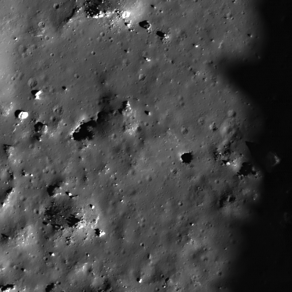
Debris of variable reflectivity and size litters the floor of a small crater in the nearside lunar highlands (31.3°N, 34.45°E). Illumination is from the south, image field of view is approximately 410 meter across; from LROC Narrow Angle Camera (NAC) observation M170334512L, orbit 10236, September 10, 2011, native resolution 0.47 meters per pixel from 38.77 kilometers. View the full size (1000 x1000) LROC Featured Image HERE [NASA/GSFC/Arizona State University].
James Ashley
LROC News System

What causes such an astonishing range in textures and tones as we find in this image? Here we see a jumbled mixture of light and dark, blocky boulders (many the size of small buildings), finer deposits between and around the boulders, and dark (low albedo), flat zones that are almost completely free of boulders. A landscape formed in an instant - ground zero for one of the most violent processes found in planetary studies.

The tremendous energy released when an asteroid or comet slams into the Moon results in compression, shattering, accelerating, melting, and even vaporizing of target and impactor. Why so much energy? Hypervelocity is the answer - the bolide (comet or asteroid) is typically traveling greater than 15 km/second; scientists estimate the energy of impact in terms of megatons equivalent of TNT because the interaction is truly explosive. Hyperveolcity is different from a low-velocity impact, which might displace some rock and make a thud, but will not produce an explosion and larger crater. Hypervelocity craters are many 10s of times the diameter of the bolide that creates them.

A wider view across the width of the LROC NAC frame provides context for the featured area deeper within the impact crater (image field of view roughly 1800 meters across. View the larger (1000 x 1000) context image release HERE [NASA/GSFC/Arizona State University].

Following an impact, some material falls back into the cavity, either as mass wasting off the crater walls or as direct in-fall from the ejecta plume. Depending on the velocity of the impactor, the impact angle, the size of the impactor, and gravity, the amount of material that is ejected or stays within the crater varies widely. Impact melt, which tends to be a darker deposit than many types of bedrock because of its glass content, will flow and pool in low-lying areas and also coat some of the boulders in encounters on its way. This accounts for the range in reflectivity and the smooth, flat areas on the crater floor in this Featured Image. This crater also has a high-reflectance ejecta blanket that can be seen in the regional WAC mosaic, provided below. Exploration of craters like this provide subsurface samples to future explorers, which in turn provide insights into the local three dimensional geology and the impact process that formed the crater.

WAC monochrome (604 nm) mosaic from four sequential orbital observation opportunities (LRO orbits7281-7284) January 21, 2011 reduced from an original resolution averaging 60 meters per pixel from 43.5 kilometers. The image shows some of the complex region in the vicinity of the small crater. A light ejecta blanket surrounding the impact is easier to see in the original context image accompanying the LROC Featured Image HERE. (FOV above is approximately 110 kilometers across [NASA/GSFC/Arizona State University].

Examine the full NAC image for additional occurrences of impact melt and other features. More examples of small, young craters can be found in Featured Image postings Brayley G, Recent Impact in Oceanus Procellarum, and Farside Impact!

Tuesday, February 7, 2012

LROC: A Recent Journey

A large boulder stopped on its way down a sloping wall in the central peak complex of Schiller crater (51.8°S, 320.0°E). Illumination from the north, image is ~500 m across, LROC Narrow Angle Camera (NAC) observation M109502471L LRO orbit 1271, October 6, 2009. See the more detailed full size LROC Featured Image HERE  [NASA/GSFC/Arizona State University].
James Ashley
LROC News System

The lonely journey of this large boulder is apparent from its track in a sloping regolith surface. A casual glance might suggest that it happened last week, or even that its rolling might resume at any moment. However, closer inspection will detect a few craters that clearly superpose and therefore post-date the track, showing that this 9-meter diameter boulder stopped rolling some time ago. Impacts are used in this way to provide a relative sense for the timing of events on planetary surfaces across the solar system. The procedure assumes a steady flux of impacting bodies in each size range, with smaller impacts being much more frequent than large impacts.

Though long ago to humans, however, this boulder's journey was made in geologically recent times. Studies suggest that regolith development from micrometeorite impacts will erase tracks like these over time intervals of tens of millions of years. If rate estimates are accurate, this boulder track might not be older than 50-100 million years. Eventually its track will be erased completely. What might have caused the rock to roll so recently? Perhaps this boulder was sent on its way by ground-shaking caused by the violence of a nearby impact. Perhaps a direct hit by a small meteoroid did the job.

Wide Angle Camera (WAC) mosaic image covering a portion of Schiller crater, north is up, image is ~80 km across [NASA/GSFC/Arizona State University].
The LROC WAC Global 100 meter mosaic draped over the laser altimetry (LOLA) digital elevation model as seen from an imaginary point 65 kilometers over the elongated crater's southeast. ILIADS application from NASA Lunar Mapping and Modeling Project (LMMP). South-southeast of center darker surface indicates the location of a localized pyroclastic volcanic dome, with a very low profile. The unusual Schiller crater formation may indicate the formation's progenitor was a highly oblique impact, perhaps along the northern inner rim of an older, much larger impact basin further southwest. Schiller is roughly 108 km wide and 184 km long [NASA/GSFC/Arizona State University].
The WAC-derived GLD100 Digital Elevation Model (DEM) of the area, shown in the inset below, offers a sense for topographic relief unavailable in the WAC mosaic alone. We can see that the location of today's Featured Image is in a zone of relatively gradual slope, just beyond the steeper slopes of the Schiller central peak complex. Thus, it is unlikely that our boulder will continue rolling anytime soon. It's arrived in an area with too gentle a slope.

Color LOLA DEM of Schiller environs, with an inset showing the central peak complex region in three dimensions. The yellow arrow designates the Featured Image location [NASA/GSFC/Arizona State University]

Look for other boulder tracks in the full NAC image.

Additional examples of boulder behavior can be seen in A Gathering in Lacus Mortis, Sampling Schrödinger, and Frozen in Time.

Tuesday, January 31, 2012

View from Vavilov

Vavilov (0.8°S, 138.8°W), the 'relatively recent' 98 km crater straddles a crossroads in the violent timeline of the Moon's history and sports some of the Moon's highest elevations on the northern and western rim. Interestingly, Vavilov formed nearly on top of a similarly sized and much older crater whose rim is still visible as a semicircle immediately northeast. Both craters carved out the same unique notch in the west wall of Hertzsprung impact basin. Image from 160 kilometer wide field of view cropped from a LROC Wide Angle Camera monochrome (566 nm) mosaic stitched from eight June 3, 2010 orbital viewing opportunities averaging 76 meters per pixel with an incidence angle of 64.5° from 55 km altitude [NASA/GSFC/Arizona State University].
WAC-derived elevation model (GLD100) Scene elevation (meters)
minimum = 2131.00, maximum = 9317.00 NASA/GSFC/Arizona State
University].
The elevation models of the Moon, built up during the record-breaking first 10,000 orbits by the Lunar Reconnaissance Orbiter (LRO), are finally allowing us to see the lunar surface in definitive detail. Naturally, this is especially true of the farside, invisible from Earth, and the polar regions. Even the vast highlands of the farside, unseen before 1959, have either been imaged at very wide angles or at low angle in part.

The Lunar Reconnaissance Orbiter Camera (LROC) in particular has been a spectacular success at imaging nearly half the Moon's surface at very high resolution and in surveying the entire Moon under a wide range of lighting conditions. One result is a highly accurate digital terrain model that just keeps getting better.

A weak attempt to represent a 100 degree wide panorama of the Vavilov interior and southern rim from its highest elevations situated along that crater's north rim. For the first time LROC is allowing us to imagine what that view might be, but it still does such a scene little justice to squeeze it into a 580 pixel-wide image [NASA/GSFC/ILIADS/Arizona State University].
Until LRO, many, but not all, of the wide angle views of the lunar farside have been focused on low resolution wavelength analysis, albedo, mineral and some low light relief. And even millions of laser altimetry measurements haven't matched the number of points recorded by LOLA during the LRO's present mission, already in lunar orbit far longer than any previous spacecraft. The record of the location of places photographed and measured hasn't been helped by the simple fact that no one really knew the Moon's actual shape and size with a high accuracy until Japan's Kaguya (SELENE-1) mission.

The Moon's highest elevations (10,761 meters) are now believed to be more than 600 km northwest of Vavilov, on the rounded wide rim of the crater Engel'gardt, but as we round the Moon's western rim, past Oceanus Procellarum and north of Mare Orientale where the farside highlands begin, and continue to proceed westward along the Moon equator the first very highest elevations encountered are on the north and western rim of Vavilov.

Easily among the highest elevations east of Engle'gardt East is on the upper reaches of the slumping wide north wall of Vavilov. We can only guess whether those heights could have once been much higher. The chaotic terraces of the western interior of Vavilov testify to a high degree of slumping, massive landslides underway since the crater formed. LROC WAC observation M130205287C (566 nm), orbit 4321, June 3, 2003; incidence 64.67° with a resolution of 77.11 meters per pixel, from an altitude of 55.31 km [NASA/GSFC/Arizona State University].
That Vavilov is deeply notched into the west-southwestern wall of the vast Hertzsprung impact basin is not something one can easily tell from Clementine (1994) albedo imagery, for example. So many craters with extended ray systems, like Jackson, overlap over the farside highlands, already bright for their relative lack of the mare-filled basins that dominate the nearside, that getting a gauge on elevations has remained elusive until the LRO mission. With the human eye alone its nearly impossible. But there is a reason why Vavilov is different, and higher, in one half than the other.

The west-southwest of Vavilov is not as stark a contrast in elevations as its north wall but the elevations are still respectable. The highest point along that rim is 9317 meters, among the Moon's highest places, and the high ejecta blanket, outside Hertzsprung on this side of the crater, tapers off less dramatically as well. The interior on the west side of Vavilov is more dramatically terraced, and this was probably not the original rim, its original circumference having collapsed, probably many times. The view seen in high detail in LROC Narrow Angle Camera (NAC) M151440688L shows a couple of kilometers-wide strip near this high elevation, and that along with other detailed images seem to show the process of slumping is still, slowly, underway. LROC WAC  observation imaged at the same opportunity, LRO WAC observation M151440362C, orbit 7451 February 4, 2011; incidence angle 51.43° at a resolution of 81.2 meters per pixel from 58.55 km [NASA/GSFC/Arizona State University].
The Vavilov impact event was not the first to carve out a place on the wall of Hertzsprung. The crater is offset just a little to the southwest from the crater, of almost identical size, that first made the notch and first interrupted the full circle of the 590 km-wide Hertzsprung impact basin. Vavilov's progenitor came close to erasing it's sister sometime after, and all that remains of the older crater is a semicircle like a cup handle attached to Vavilov's northeast.

The LROC WAC-derived Digital Elevation Model (GLD100) brings Vavilov out of the glare, in false color. The terrain was already on the rise from the southeast before the Hertzsprung or Korolov (further westward along the farside equator) because the formation of the Moon's oldest, deepest and largest known South Pole Aitken impact basin, further southeast may have help to lift the whole wider area along its perimeter here 4 billion years ago. The uplift of the third ring of mountains around Hertzspring rose still higher, first interrupted here by the arrival of Vavilov D. The area carries the deep scars and secondary craters of what some believe to be the most recent mare-filled basin-forming impact at Orientale, to the southeast. Vavilov probably formed after that event, superimposed on all those more ancient happenings. Vavilov is about seven kilometers deep, from its floor to the heights on its north and west rims [NASA/GSFC/DLR/Arizona State University].
The high western side of Vavilov perched on the southwestern outer ring of Hertzsprung and, on closer examination, the scaring and secondary crater chains radiant from the energetic impact that formed Mare Orientale, straddling the Moon's west limb and visible on edge from Earth. The most influential morphology that lifted this area is mostly invisible from Earth, the wide and deep 4 billion year old South Pole Aitken (SPA) basin at lower left. Orthographic projection over the intersection of the Moon's equator and its 240th meridian east [NASA/GSFC/DLR/Arizona State University].
Vavilov was unfavorable placed for the Apollo mapping cameras, and not well situated, nor a priority, for the Lunar Orbiter photography before Apollo. Other than the polar regions, this area of the Moon received less attention than most other areas until Clementine, and then from a low-resolution experimental remote sensing standpoint. LRO has changed that, however, and so much else. We now know that the view, and from the standpoint of science, the excavation performed by the Vavilov progenitor warrants more attention.

Even from orbit Vavilov must be spectacular.

Courtesy of the NASA ILIADS application, the LROC 100m WAC Global Mosaic draped over the LOLA 128 px DEM (v.2), the simulated "orbital view" of Vavilov from 65 km over the center of Hertzsprung basin.