 |
| All of the farside highlands crater Moore F has been photographed at high-resolution since the impact melt of its interior was featured in an LROC release October 30, 2009 (FOV below = yellow arrow) [NASA/GSFC/Arizona State University]. |
 |
| LROC FEATURED IMAGE OCTOBER 30, 2009: Frozen impact melt flows on the floor of Moore F, a farside highlands
crater. LROC Narrow Angle Camera (NAC) Nominal Mission observation M110383422LE, LRO orbit 140, October 17, 2009; 600 meter field of view, incidence angle = 41.15° at a resolution of 0.61 meters per pixel from 59.16 kilometers altitude. View the larger original LROC Featured Image HERE
[NASA/GSFC/Arizona State University]. |
 Jeff Plescia
LROC News System
Jeff Plescia
LROC News System
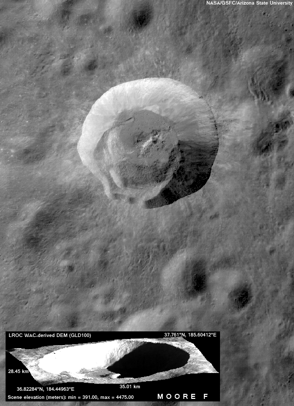
The crater
Moore F (
37.4°N, 185°E ~ 23 km) exhibits a spectacular terraced rim and central uplift – a beautiful example of a
complex impact structure. Surrounding the central uplift, the crater floor is covered by both frozen impact melt flows and debris. The melt formed as a result of the tremendous energy released in the impact event. As the crater equilibrated, the melt flowed to low spots and slowly cooled. What caused the spectacular curved cracks to form?
Perhaps the crater floor topography changed over time, fracturing the surface of the central melt pond deposit (right side of picture) and opening a series of parallel, arcuate tension (pull-apart) cracks. Or, perhaps as the melt cooled and solidified, the volume change opened the cracks. The LROC
featured image on October 21 showed an adjacent portion of this same crater. Over time, LROC will image the whole crater allowing scientists to test these hypotheses and come to a clear understanding of how craters of this size form.
 |
| Closer is not necessarily more informative when sorting though the hundreds of LROC Wide Angle Camera (WAC) observations of Moore F crater. For example, in orbit 10090 (August 30, 2011), the LRO spacecraft resolved Moore F from 40.6 kilometers, and at nearly the same illumination as seen above. That field of view can be seen HERE, and considerable processing will be needed to tease more information than what's readily seen from 15 kilometers higher, above. M158748657CE (604 nm), LRO orbit 8529, April 29, 2011; incidence = 49.73° at 77.235 meters resolution from 55.45 kilometers altitude [NASA/GSFC/Arizona State University]. |
Explore the original LROC Featured Image released October 2009,
HERE.
 |
| As LRO approaches it's record-breaking third year in lunar orbit, the flood of data continues to allow finer granularity to be refined into what will undoubtedly be our definitive "map" of the Moon for decades to come. Moore F (center, yellow circle) is situated on the opposite side of the Moon from Earth, a place now better understood than the nearside was at the beginning of the 21st century. Wide Angle Camera-derived Digital Elevation Model (128), centered over the equator at its intersection with the 180th meridian [NASA/GSFC/DLR/Arizona State University]. |

No comments:
Post a Comment