Sunday, July 18, 2010

Al Bean inducted into National Aviation Hall of Fame in Dayton, Ohio


Apollo 12 lunar module pilot Alan Bean, active as a renowned artist and speaker, 40 years after he became only the fourth human to walk on the Moon (November 1969).

DAYTON, Ohio — The pilot of the lunar module for the second moon landing is among four people newly inducted into the National Aviation Hall of Fame in Ohio.

Capt. Alan Bean, of Apollo 12's November 1969 moon mission, discussed the landing Saturday at an induction ceremony in Dayton. The 78-year-old from Houston recalled looking out the window of the 6,000 mph spacecraft as it circled the moon 45 miles below.

Also enshrined were: Clay Lacy, a business aviation entrepreneur and cinematographer; the late Warren Grimes, called the "father of aircraft lighting" and an inventor of navigation instruments; and, the late Noel Wien, Arctic flight expert and Wien Alaska Airlines founder.

They joined 203 previous inductees in the hall founded in 1962 in the hometown of the Wright brothers.

Handling 2.76 TB of Chang'E-1 data

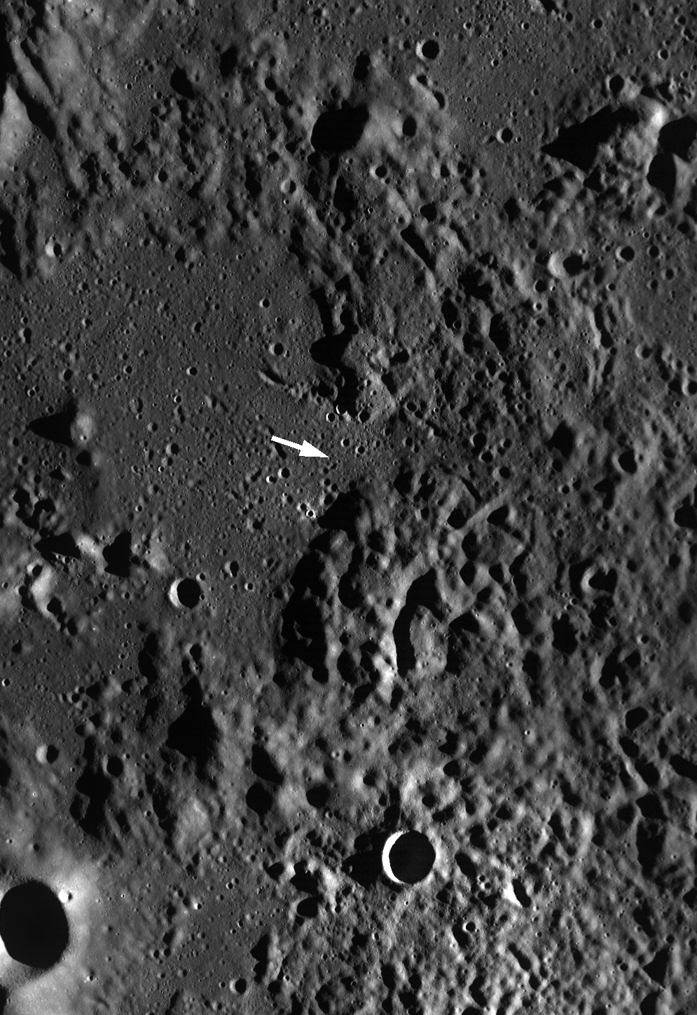
Possible impact site of China's first lunar orbiter Chang'E-1, at or near 1.5ºS, 52.36ºS, 0813 1 March 2009 UT. LROC Narrow Angle Camera (NAC) observation M111253255LE, LRO orbit 1529, October 27, 2009; (Slew angle 7.64º, emission angle 9.55º) Resolution 0.53m, image width 624 meters [NASA/GSFC/Arizona State University].

(Xinhua News Agency) China's space agency has set up a committee of 123 leading scientists to consider how the country might apply the vast amount of data acquired by China's first lunar probe.

The project had resulted in data about the distribution and content of important elements on the moon, such as uranium, thorium, potassium, aluminum, silicon, iron and titanium, said the State Administration of Science, Technology and Industry for National Defense Friday.

China launched its first lunar probe Chang'e-1, named after China's mythical Moon Goddess, on Oct. 24, 2007 in southwestern Sichuan Province. The probe ended its 16-month mission on March 1, 2009, when it hit the lunar surface.

The administration said in a statement that China was making "periodic" progress in processing, analyzing and studying the data from the probe, and the "world class" map of the moon's entire surface.

The map, produced by a stereo camera using a charge-coupled device (CCD) on the probe to form images, was highly accurate, said Ouyang Ziyuan, chief scientist of China Lunar Exploration Project.

Chang'e-1 had produced digital elevation models and a three-dimensional topographical map with the highest possible accuracy and resolution, he said.

The probe had also provided researchers with data on the microwave radiation temperatures of the lunar regolith, the powdery soil layer on the moon's surface, which was significant to identify the thickness of the regolith and the rare gases within it, said Ouyang.

"Unique" data about the high-energy particles in near-lunar space and solar-wind particles had also been obtained, which would enrich knowledge about solar radiation, the magnetic field between the sun and the earth, and the moon, Ouyang said.

The scientists, from some of China's leading research institutions and universities, would consider about 2.76 terabytes (TB) of data generated from the 1.37 TB of information sent back from Chang'e-1, said Ouyang.
Link to YouTube presentation by Dennis Wingo, on LOIRP utilization and the future of lunar exploration, posted to Moonviews.com by Keith Cowing (47:27).

Saturday, July 17, 2010

LOLA: Schrödinger Basin


NASA GSFC - Schrödinger (centered -75.0˚, 132.4˚ E), located on the lunar far side and within South Pole-Aitken Basin, is not visible from the Earth. Crater counts suggest that the basin is less than one billion years old, making it the second youngest impact basin on the Moon (the youngest being Orientale).

LOLA data reveal that the basin has approximately 3.3 km of relief from rim to floor. The basin’s inner ring is clearly visible, as are lunar rilles, smaller impact craters, and a volcanic cone (see arrow).

LROC Narrow-Angle Camera (NAC) closeup of clustered craters on the lip of the Schrödinger pyroclastic cone, a Constellation Region of Interest (ROI). Although believed to be relatively young, these craters have a subdued appearance, a texture smoothed by micrometeor 'gardening' typical of older lunar surfaces) because they formed in loose pyroclastic material. LROC NAC Frame M108313384R, this view is 785 meters across [NASA/GSFC/Arizona State University].

The cone is believed to be pyroclastic in nature, largely due to the dark halo that can be seen surrounding it in visible light images. The LRO narrow angle camera also captured a view of the cone. Additional evidence for volcanic activity comes in the form of rilles and the relatively flat and smooth basin floor, which is most likely the result of infill by lava flows.

More information and images available from "Craters on the Schrödinger pyroclastic cone," expanding on the Lunar Reconnaissance Orbiter Camera (LROC) Featured Image and commentary by Lisa Gaddis, April 24, 2010.

Friday, July 16, 2010

NASA's new mission and the cult of management


Paul D. Spudis
Smithsonian Air & Space

During a recent interview on Al Jazeera television, NASA Administrator Charles Bolden outlined NASA’s new priorities. His remarks became headlines as the previously ignored story about the redirection of the space agency toward international diplomatic outreach and global climate change research finally reached the many who still hold NASA in high regard. Beyond the inane and vacuous policy comments, one statement by Administrator Bolden went virtually unnoticed: “We’re not going to go anywhere beyond low Earth orbit as a single entity,” he revealed, “The United States can’t do it.” If it’s possible to shock Americans into paying attention to NASA and our national space program, those words might do it.

It’s one thing to assert that the Unites States desires more international collaboration as a matter of policy for reasons of fostering alliances, developing new cultural ties, or even to promote world peace. It’s an entirely different proposition to assert that the United States has lost the ability to reach for the stars, that America is incapable of exploring space alone. Have we become comfortable with the idea that it’s politically incorrect to have pride in our nation’s abilities – past, present and future?

The natural reaction of many Americans is to strongly protest such a notion by asserting that our technology is the greatest in the world and that we can design and build anything we choose to. However, one can not escape the reality that the statement quoted above was made by the head of the agency charged with sending U.S. astronauts into space, a task that Americans have watched NASA carry out for almost 50 years. A more troubling thought is that maybe he is right.

I’ve worked with NASA for 25 years on experiments, research, and advanced planning and missions. I’ve been involved with studies to put a base on the Moon since 1984 (the year of the first conference on lunar bases at the National Academy of Sciences in Washington DC). In all of these efforts, I believed that our future in space was at stake and that we were preparing for humanity’s return to the Moon, followed by journeys to the planets.

As the years wore on, it began to dawn on some of us that some within and outside the agency really didn’t want to go anywhere or do anything in space. Working for NASA means being involved in the process of working. How you structure a project, who gets assigned what work and how many meetings you conduct is the formula that elevates you faster than when (or even if) you deliver a product, a mission or a program. This culture becomes even more evident as one ascends the chain of command. The farther up the organizational ladder you go, the further removed from the productive segment of the agency you are, with product being replaced by an ever multiplying and bewildering variety of workshops, seminars and management training retreats. There exists in America today a thriving industry dedicated to convincing people who have no organizational or management skills that in fact, they are all excellent organizers and managers. Much of this sub-culture is accurately (and hilariously) portrayed in the comic strip Dilbert.

Management fads like Total Quality Management regularly come and go. NASA has dabbled in Faster-Cheaper-Better, Spiral Development, Earned Value Management, and many others. Each new initiative is unveiled as The Answer, the magic beans solution that will re-establish the NASA of our forefathers – smart, productive, innovative, and competent. Management thrives by producing more middle managers. People joke about highway projects where one guy digs a hole while five others lean on their shovels, watching him work. That old chestnut always gets a laugh because we’ve all seen it at some point. You see it a lot within NASA. As administrative cost consumes more and more of the budget pie, the slice that represents funding for the productive sector of the agency keeps shrinking.

Bolden’s comment is tragic, not in its misunderstanding but in its verity. America cannot go back to the Moon by itself not because we lack the wealth or the technical skills but because we have developed a culture of management bloat and process-orientation that proliferates bureaucracy. NASA is comfortably cushioned from the reality of their organizational maladies by the amazing legacy inherited from those who did great things in the past. They may believe they’re immune to the Cult of Management, but as evidenced by Bolden’s statements, the agency has changed. NASA has become a “feel-good” bureaucracy, stuck on the idea of doing one-off stunts in space for public approval and a guaranteed institutional lifetime, paid for by the public. This attitude both inside and outside of the agency has lead to the demise of our national spaceflight capabilities. Stagnant entities reflexively dwell on past glory; dynamic ones build upon them to create something both significant and permanent.

Occasionally, I’m asked why I stay in the space business. I do so because I believe in the mission of space exploration and in the importance of moving humanity into the Solar System. Every now and then, an opportunity arises outside the boundaries of normal business to do something productive and create a lasting legacy – a time when the stars align and a leader refuses to follow the established rules or to unimaginatively subscribe to the conventional wisdom.

Currently, the “right stuff” manifests itself as a pattern of waiting for a propitious political opportunity and a few far-seeing people to seize the day and push through something that otherwise would be buried by “process.” In my opinion, the Vision for Space Exploration was such an opportunity – a path forward, achievable in stages, that would have created a legacy of space faring capability. The idea of actually doing something made the Vision a nonstarter to many within the agency – it challenged their worldview of process over product. They are content to merely manage an organization. The goal of leading America and the world into the Solar System has become a slogan in a strategic plan, an ever-fading banner over an office door.

Is any of this fixable? Perhaps. For now, the opportunity to strengthen the U.S. space program, an endeavor that has traditionally pushed technology development and stoked our economic engine, has been kicked aside. But by their very nature, new opportunities arise unbidden and unforeseen at irregular intervals. I wonder if we’ll do better next time.

Americans need to wonder.

Moon walk led to 'deep' frontier


Apollo 14 lunar module pilot Edgar Mitchell surveys their map and looks for landmarks as Cmdr. Alan Shepard takes his picture, near the end of their unsuccessful walk to Cone Crater at Fra Mauro, February 1971. It was the first time an Apollo expedition had journeyed beyond view of their spacecraft [AS14-64-9088HR/NASA/ASJ].

Jim Wise
The Durham News

In February 1971, U.S. Navy Capt. Edgar Mitchell was lunar module pilot on Apollo 14, the third U.S. mission to land on the moon.

The sixth human to walk on the moon, Mitchell is a native of Hereford, Texas, and earned his doctorate in aeronautics and astronautics at MIT.

While in graduate school, he became interested in the research in "extra-sensory perception" pioneered by Duke University Prof. J.B. Rhine. Mitchell met and corresponded with Rhine and, while in space, conducted ESP experiments of his own which, he says, had positive results similar to those Rhine had had on Earth.

Mitchell was originally assigned to the ill-fated Apollo 13. Switched to the later mission, he and fellow astronaut Ken Mattingly simulated the roles of command and lunar module pilots during the efforts that brought Apollo 13's crew home safe.

During his own flight home, Mitchell had a mystical experience that radically changed his career.

"It was accompanied by this bliss, or ecstasy - a 'wow' experience," he said later.

According to his Website Mitchell "became engulfed by a profound sensation "a sense of universal connectedness. He intuitively sensed that his presence, that of his fellow astronauts, and that of the planet in the window were all part of a deliberate, universal process and that the glittering cosmos itself was in some way conscious."

Mitchell retired from NASA in 1972 and founded the Institute for Noetic Sciences to sponsor research into the nature of consciousness as it relates to cosmology and causality. He is also a strong advocate for changing humans' attitude toward the earth and for protecting its resources.

On Friday, he is speaking on "Sustainability" at the Duke Center for Living. His appearance is sponsored by the Rhine Research Institute, which J.B. Rhine established upon retiring from Duke in 1964. His talk is open to the public.

Read the Article, HERE.

NASA seeks rover that goes all night

Researchers at the Field Robotics Center at Carnegie Mellon University in Pittsburgh, Pennsylvania have designed a new lunar rover capable of being both a full scientific research platform and a drilling platform. Designed to operate in wildly changing terrain, drive autonomously in full darkness, and consume very low amounts of power, Scarab was designed from the start for conditions on the moon [TheFutureofThings.com].

Rachel Courtland
New Scientist

A rover that can roam in darkness could win as much as $1.5 million in NASA prize money.

The night rover competition is one of three new "Centennial Challenges" from the agency. NASA hopes it will encourage the development of technology to explore the moon, where a solar-powered robotic explorer may face as much as two weeks of darkness.

"The motivation is energy storage technology for exploration," says Andrew Petro, Centennial Challenge programme manager at NASA in Washington DC. "We're hoping that a range of different technical solutions are brought forward, and we're not assuming it will only be batteries and photovoltaic arrays."

In addition to the night rover prize, NASA plans to offer another $1.5 million for robots that can automatically find and retrieve samples, and a $2 million purse for teams that can place a small satellite into orbit twice in one week.

Read the article, HERE.

Thursday, July 15, 2010

How common are mare pit craters?


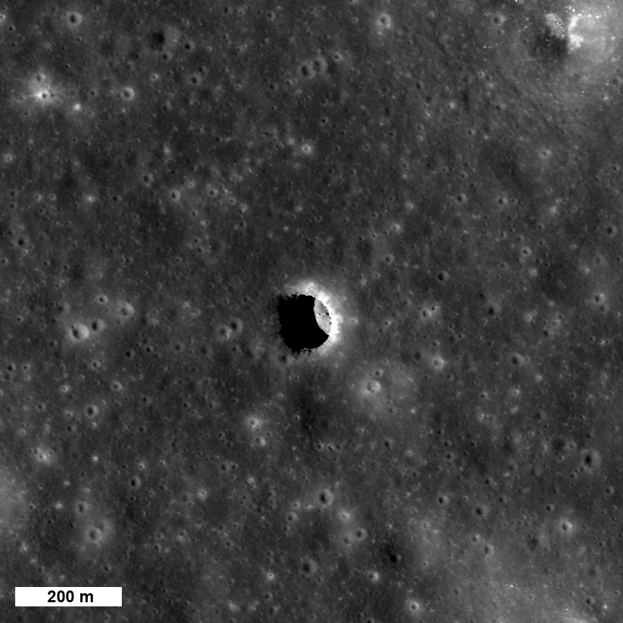
One of three large pit craters so far found on the Moon -- do these pits provide access to open lava tubes? From LROC NAC M106662246R, LRO orbit 861, Sept. 4, 2009; Alt. 133.78 km, resolution = 1.35, phase angle = 29.34° [NASA/GSFC/Arizona State University].

Mark Robinson
Principal Investigator
Lunar Reconnaissance Orbiter Camera (LROC)


The Kaguya team discovered three mare pit craters, all about 100 meters in diameter. Since the Kaguya Terrain Camera had a pixel scale of about 10 meters they could not definitively identify pit craters much smaller than 100 meters. This raises a key question - are there smaller pit craters to be found? The answer is most likely yes.

The LROC team is searching images that are already on the ground and is targeting areas around pits for more coverage. To date, we have about ten candidate pits awaiting confirmation.


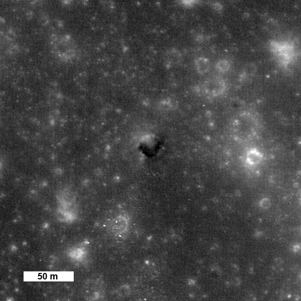
Possible small (25 meter diameter) pit crater in Mare Tranquillitatis observed under high Sun (3° incidence angle). This feature is about 200 km NW of the large pit shown in the opening image. From LROC NAC M124382509L [NASA/GSFC/Arizona State University].

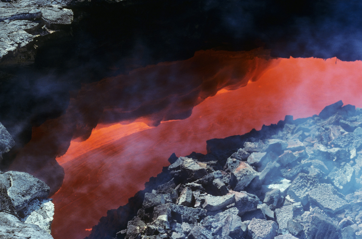
How and when did pit craters form? On the Earth volcanic pit craters are formed as the roof of a lava tube collapses, often while magma is still flowing underground. The resulting opening is often termed a skylight. Can we determine if the lunar pits formed during or after the mare lavas flowed? Perhaps the best place to start looking for evidence is on the pit crater floor. If the crater formed long after eruptions had ceased and the subsurface lava tubes were cold, you might find a chaotic pile of rubble on the floor. If the pit collapsed into an active lava tube you might find the smooth, frozen surface of the last lava to flow through the tube.


View down a skylight revealing magma racing through a lava tube in Hawaii. When lava stops flowing in tubes it cools and forms a smooth surface [photo by Mark Robinson].

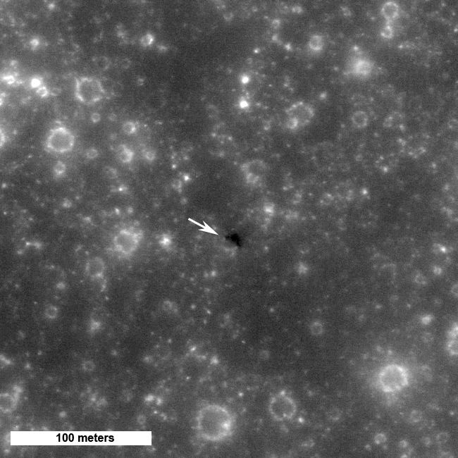
The floor of the larger pit does look smooth, but the image of the smaller pit does not have high enough resolution to give a clear picture of the interior. One might infer that the larger pit was formed as an underlying tube was active, though at this stage such a conclusion would amount to healthy speculation. The LROC team is planning to acquire stereo images of the large pits and smaller ones that are now being discovered. The detailed topographic data will allow scientists to confirm the origin of these fascinating pits. Additionally, the LROC team will acquire images at a slant attempting to look for overhangs that might indicate the lava tubes are still open and accessible. Keep checking in as this exciting story unfolds.


Another possible pit crater in Mare Tranquillitatis. LROC NAC observation M109100697RE; LRO orbit 1212, October 2, 1009, Alt. 49.11 km, phase angle 2.54° [NASA/GSFC/Arizona State University].

Examine previous images of lunar pits at Marius Hills and Mare Ingenii.

Explore on your own.


Low-resolution context for two of the three Lunar Reconnaissance Orbiter (Narrow Angle) Camera observations of verified and unverified mare crater pits within Mare Tranquillitatis. (One of the three highlighted by Dr. Robinson up above is not yet released to the Planetary Data System.) Format note: A near perfect "National Geographic-like" font stylizes the upper loop in the '8' of Ranger 8, and it has unfortunately made it appear Ranger 6 impacted the Moon at two widely different locations. Ranger 6 impacted the Moon at or near the northern designation February 2, 1964, though it's television camera had already failed after inadvertently switching on during a booster separation. Ranger 8 was successful, however, in returning televised images of the lunar surface up until the moment of its intentional impact, February 20, 1965; not far from the eventual landing sites of Surveyor 5 and Apollo 11 [Clementine 750nm- NASA/DOD/USGS].

Senate committee proposed National Space Policy shifts commercial and R&D to Heavy Lift by 2016

Nancy Atkinson

The Senate Commerce, Science and Transportation Committee has unanimously approved legislation that would add a shuttle mission and jump start work on a heavy-lift rocket next year. The NASA Reauthorization Act effectively cancels the Constellation program, but directs NASA to begin work immediately on a new heavy-lift vehicle to be ready by 2016, along with a crew vehicle. The new legislation takes money away, however, from two main focuses on Obama's proposed budget: commercial space development and funding for innovation and breakthrough technologies.

Commercial space ventures would only get $1.6 billion for development in the next three years, as opposed to Obama's plan for $3.3 billion on commercial rocket companies between 2011 and 2013.

Obama had proposed $6 billion over five years for technology development whereas the new Senate bill funds advanced technologies at about $950 million over three years.

Both of these components of the are a big disappointment for those looking towards the future and not necessarily honing in on the next few years.

The plan, mainly spearheaded by Florida Senator Bill Nelson is said to be a compromise between Obama's plan and those in Congress who opposed it.

Read the article, HERE.

Scenarios for a Shuttle-Derived HLV, Beyond Earth Orbit, including the Moon

Just as post-Shuttle development inevitably includes some kind of Heavy Launch Vehicle (HLV), there is no sound reason to halt development of some kind of manned landing vehicle. Chris Bergin outlines more than one way to get back to the lunar surface without the Ares I/V [NASASpaceflight.com].

Chris Bergin
NASASpaceflight.com/L2

Immediate mission requirements, such as logistical resupply of the International Space Station (ISS), is catered for in the FY2011 budget proposal via yet-to-launch commercial vehicles, in tandem with overseas assets such as ATV, HTV and Progress, ahead of manned requirements to take over from purchasing Soyuz seats for US crewmembers during the upcoming gap.

However, the future outlined in the budget proposal only makes a passing reference to an eventual goal of a manned mission to Mars, sometime in the 2030s. It also cancels the Constellation approach to returning to the Moon.

While the SD HLV assessment is not a policy document – instead finalizing all the evaluations into the SD HLV, potentially for the benefit of documenting the work for a commercial entity picking up on the design – the findings do provide interesting architecture approaches for both Lunar and BEO missions.
Part 1: Completed SD HLV assessment highlights low-cost post-Shuttle solution

Part 2: SD HLV review outlines ISS Logistics and Transport

Part 3. SD HLV, Commercial and International architecture outlined

ARC: Communicating science through art

Andrew Chaikin

NASA Ames Research Center - Author and space historian Andrew Chaikin will discuss lunar exploration and astronomer/artist Jose Francisco Salgado will present a multimedia demonstration entitled, "Communicating Science through Art," on Wednesday, July 21, at 7 p.m. PDT in the tent adjacent to the Ames Conference Center, Building 3.

Chaikin will talk about how our understanding of the moon has been transformed by recent discoveries from LCROSS, LRO and Chandrayaan 1 missions.

Chaikin has authored books and articles about space exploration and astronomy for more than 25 years and is best known as the author of "A Man on the Moon: The Voyages of the Apollo Astronauts."

Salgado is an astronomer and science visualizer at the Adler Planetarium in Chicago. Formally trained in Physics and Astronomy, he uses his skills in astronomy education and visual arts to create multimedia works that communicate science in engaging ways.

Advance tickets are required for admission to this free event. Please visit HERE to request your tickets (limit 5 tickets per family). PLEASE NOTE: Plan to arrive early; once the tent is filled to capacity, the overflow crowd will be seated in Building 3 to view the event via videoconference.

NASA ARC is a federal facility. A government-issued photo-ID (such as a driver's license) is required for entry. This lecture is sponsored by the NASA Lunar Science Institute.

Wednesday, July 14, 2010

The Moon's largest (known) impact basin


The Four billion year old South Pole-Aitken (SPA) basin, the oldest and largest yet identified on the Moon, was readily visible just as soon as the Soviets obtained humanity's first, hazy telephoto view of the Far Side, barely more than fifty years ago. Above its tortured interior, stretching from near the equator, overlapping the South Pole, to the Near Side is equally unmistakable in a preliminary rendition of LRO (LOLA) laser altimetry. (Reproduced from "Ten Cool Things Seen in the First Year of LRO," NASA, June 23, 2010) [NASA/GSFC/Arizona State University].


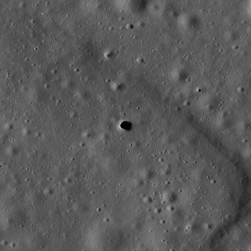
A narrow view through the LRO Narrow Angle Camera (LROC NAC) northeast of Ballingauzen, showing the largely unexplored surface of one of the vast number of basalt plains encircled by SPA's outer wall of mountains. "A crater within a crater within a basin, the interior of the South Pole-Aitken basin is one of the most compelling destinations on the Moon. (LROC NAC image M103196768LE, LRO orbit 377, alt. 46.69km, July 27, 2009; Resolution 0.51cm - field of view is 520 meters [NASA/GSFC/Arizona State University].

Brett Denevi

LROC News System

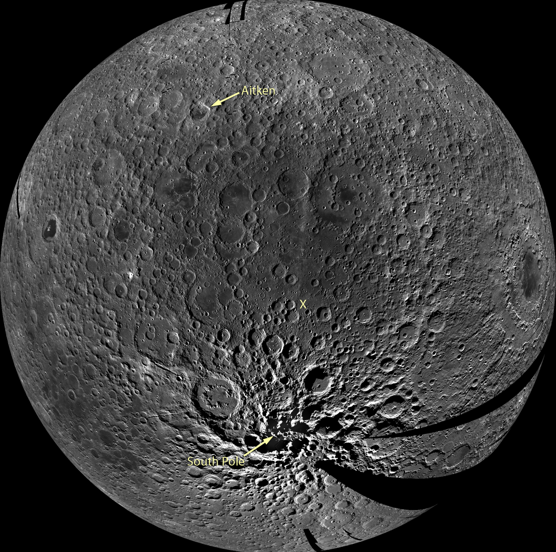
South Pole-Aitken (SPA) basin is the largest and oldest recognized impact basin on the Moon. It's diameter is roughly 2,500 km or 1,550 miles. The Moon's circumference is just under 11,000 km, meaning the basin stretches across nearly a quarter of the Moon. In the LROC WAC mosaic below, which is centered on the middle of the basin, you can see SPA as an area of relatively low reflectance extending from the crater Aitken in the north and all the way down to the South Pole. Topographic data from LOLA can also help to give a sense of the enormous effect the SPA impact had on the Moon - the basin is more than 8 km (5 miles) deep.


A preliminary monochrome mosaic of the Moon from the LROC Wide Angle Camera (WAC), centered in the middle of the South Pole-Aitken basin. Arrow points to the South Pole and an X marks the Constellation region of interest within the basin and the location of the NAC detail above [NASA/GSFC/Arizona State University].

Stratigraphic relationships show that SPA is the oldest impact basin on the Moon, but scientists are intensely interested in just how old it is. Lunar samples suggest that most of the major basins on the Moon formed around 3.9 billion years ago in a period called the late heavy bombardment. By this time most of the large debris within the solar system should have already accreted to form the planets, so such a large number of big impacts occurring at nearly the same time may have been due to unusual gravitational dynamics in the early Solar System. Was the impact that caused the SPA basin also a part of some cataclysmic event that occurred 3.9 billion years ago? If so, that impact is strong evidence for an extreme event that would have affected all of the terrestrial planets, including Earth at a time when life was just beginning. If the basin is much older, that may suggest that instead of a spike in the impact rate at 3.9 billion years, the number of impacts simply trailed off from a peak earlier on.

How can we find out just how old the SPA impact basin is?

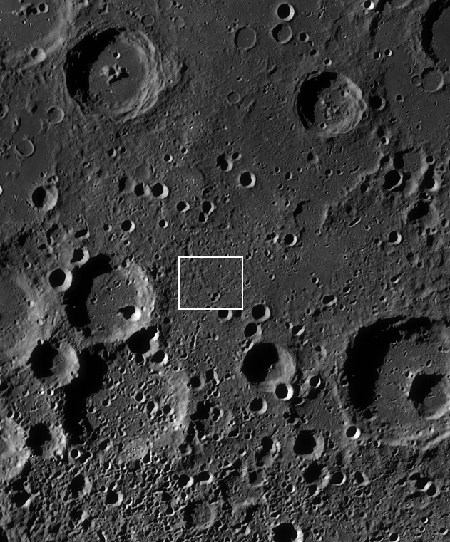
The best way would be to sample materials from the interior of the basin and use radiometric age-dating techniques to determine when they were last molten, as heat from the impact would have melted a large volume of material, resetting radiometric clocks. But the basin is so old that its surface has been cratered many times over, meaning that some of the rocks would have had their radiometric ages reset by these subsequent impacts. So it may be difficult to find rocks with ages that truly reflect the SPA event without careful consideration of the local geology. The Constellation region of interest, highlighted in the NAC detail above and outlined in the WAC mosaic below, was selected because it is in a deep portion of the basin, where a large volume of melt would be expected. Some of this melt would remain as a significant component of the soil, and an analysis of a carefully selected suite of samples from this region would reveal the age of the oldest lunar impact basin.


WAC monochrome mosaic of the interior of SPA, zoomed in to show the 40x40 km Constellation region of interest (white box) and surroundings [NASA/GSFC/Arizona State University].

One final note - imagine the view of the Moon from the Earth when the SPA impact occurred. What would it have looked like? How much ejecta would have landed on the Earth? How long would it take for ejecta to reach the Earth? Surely this impact profoundly affected the young Earth.

Where would the best sample site be? Browse the full-resolution NAC image and WAC mosaic and decide for yourself!

Tuesday, July 13, 2010

NASA@Science: "Down the lunar rabbit-hole"

The 'skylight' in the middle of Mare Ingenii, on the Moon's Far Side, show a tantalizing view of house-sized boulders on part of it's barely illuminated floor in this LRO Narrow Angle Camera (NAC) observation, LROC News System Featured Image released June 16, 2010. Two kilometers wide, the Ingenni pit is twice the size of the skylight previously unveiled by JAXA SELENE-1 (Kaguya) investigators in 2009 - [M128020284LE, LRO orbit 4026, May 11, 2010 - NASA/GSFC/Arizona State University].

Dauna Coulter
Science@NASA

A whole new world came to life for Alice when she followed the White Rabbit down the hole. There was a grinning cat, a Hookah-smoking caterpillar, a Mad Hatter, and much more. It makes you wonder... what's waiting down the rabbit-hole on the Moon?

NASA's Lunar Reconnaissance Orbiter (LRO) is beaming back images of caverns hundreds of feet deep -- beckoning scientists to follow.

"They could be entrances to a geologic wonderland," says Mark Robinson of Arizona State University, principal investigator for the LRO camera. "We believe the giant holes are skylights that formed when the ceilings of underground lava tubes collapsed."

Japan's Kaguya spacecraft first photographed the enormous caverns last year. Now the powerful Lunar Reconnaissance Orbiter Camera (LROC, the same camera that photographed Apollo landers and astronauts' tracks in the moondust) is giving us enticing high-resolution images of the caverns' entrances and their surroundings.

Situated a bend at the northwestern reaches of the unofficially named sinuous rille 'A,' near the heart of the widespread Marius Hills volcanic region in Oceanus Procellarum, the "Haruyama" skylight (unofficially named, for the lead investigator of the JAXA SELENE-1 (Kaguya) science team who first identified it) is wide enough to swallow The White House in Washington, DC (LROC Narrow Angle Camera observation M114328462RE; LRO orbit 1982, December 1, 2009; Alt. 45.38 km, Resolution = 50cm per pixel) [NASA/GSFC/Arizona State University].

Back in the 1960s, before humans set foot on the Moon, researchers proposed the existence of a network of tunnels, relics of molten lava rivers, beneath the lunar surface. They based their theory on early orbital photographs that revealed hundreds of long, narrow channels called rilles winding across the vast lunar plains, or maria. Scientists believed these rilles to be surface evidence of below-ground tunnels through which lava flowed billions of years ago.

"It's exciting that we've now confirmed this idea," says Robinson. "The Kaguya and LROC photos prove that these caverns are skylights to lava tubes, so we know such tunnels can exist intact at least in small segments after several billion years."

Context for the LROC NAC image of the Marius Hills 'skylight,' is LROC Wide Angle Camera (WAC) image M117867923ME, showing a 26 km-wide area in the heart of the Marius Hills. The white arrow designates the location of the pit, at the bend in "Sinuous Rill A." The location is almost directly situated between the two main volcanic vents of what China's Chang'E-1 orbiter team have labeled "Yutu," theorized to be an extinct single volcanic under the entire Marius dome region, a claim perhaps backed up by LRO (LOLA) laser altimetry data [NASA/GSFC/Arizona State University].

Lava tubes are formed when the upper layer of lava flowing from a volcano starts to cool while the lava underneath continues to flow in tubular channels. The hardened lava above insulates the molten lava below, allowing it to retain its liquid warmth and continue flowing. Lava tubes are found on Earth and can vary from a simple tube to a complex labyrinth that extends for miles.

If the tunnels leading off the skylights have stood the test of time and are still open, they could someday provide human visitors protection from incoming meteoroids and other perils.

"The tunnels offer a perfect radiation shield and a very benign thermal environment," says Robinson. "Once you get down to 2 meters under the surface of the Moon, the temperature remains fairly constant, probably around -30 to -40 degrees C."


Lunar Orbiter IV (1967) photographed the Marius Hills region from 2668 km (1967,) shown in this "no dash" noise-reduction of the original image by the USGS Lunar Orbiter Digitization Project (not to be confused with the Lunar Orbiter Image Restoration Project, or LOIRP, who re-creating Lunar Orbiter images directly from restored telemetry). The sinuous rilles shown above are barely visible in the upper left center. Much detail from the original image is lost in the reduction to merely 400 pixels. Nevertheless, the larger context for the region-at-large is seen here, and the neighbors, including many of the Marius domes (visible with the Sun illuminating from the right, 27° over the eastern horizon. At center left is Rima Galilaei and the bright surface feature in the south is the frilly northeastern extremes of the Reiner Gamma albedo swirl phenomena, suggesting it also may be related to an extinct regional "Yutu" volcano; a very large part of Oceanus Procellarum. (Image width is about 160km) [NASA/JPL/USGS].

That may sound cold, but it would be welcome news to explorers seeking to escape the temperature extremes of the lunar surface. At the Moon's equator, mid-day temperatures soar to 100 deg C and plunge to a frigid -150 deg C at night.

Paul Spudis of the Lunar and Planetary Institute agrees that lunar lava tubes and chambers hold potential advantages to future explorers but says, "Hold off on booking your next vacation at the Lunar Carlsbad Hilton. Many tunnels may have filled up with their own solidified lava."

However, like Alice's Queen of Hearts, who "believed as many as six impossible things before breakfast," Spudis is keeping an open mind.

"We just can't tell, with our remote instruments, what the skylights lead to. To find out for sure, we'd need to go to the Moon and do some spelunking. I've had my share of surprises in caving. Several years ago I was helping map a lava flow in Hawaii. We had a nice set of vents, sort of like these skylights. It turned out that there was a whole new cave system that was not evident from aerial photos."

As for something similar under the lunar skylights?

"Who knows?" says Spudis. "The Moon continually surprises me."

This could be a white rabbit worth following.

Further Reading:

Depths of Mare Ingenii, June 16, 2010

Hearts of Marius, Shadows of Yutu, May 29, 2010

Local Topography and Reiner Gamma, May 22, 2010

LRO/LROC/LOLA: Marius Hills, March 20, 2010

Monday, July 12, 2010

As New as a New Moon can get

Astronomers and astro-tourists traveled to Chile, French Polynesia and the southeastern Pacific Ocean to experience the solemn magnificence of a Total Eclipse of the Sun, July 11.

SpaceWeather.com and other sites can be counted on to post images as they circulate in coming days, like the above by Constantinos Emmanouilidis, imaged through intermittent cloud cover over the Cook Islands, Sunday.

Preliminary stills at Totality, often through thin cloud cover, reveal a respectable Earthshine bringing Near Side features into view along with perhaps distinctive blue added one might suppose from two-thirds of the Pacific illuminating Grimaldi, Imbrium, Procellarum and Crisium, etc.

Issac Asimov once noted that this occasional intersection, with predictable regularity, of the very outermost of last 100 kilometers or so of the cone of our Moon's central umbra with Earth's outermost surface seemed to him so improbable as to be impossible. Considering the real distances versus the apparent distances to the Moon, the relative sizes and angular momentum of the Three Bodies in play, his point is well taken; adding to rather than detracting from the awesome beauty of this phenomena.

Sunday, July 11, 2010

July 11 Total Eclipse from Easter Island

Apollo 16, Footsteps Under High Sun

NOTE: The Pioneers can perhaps be forgiven if we go a bit overboard with the following highlighting of the latest Featured Image from the LROC team at Arizona State University; the Apollo 16 landing site in high Sun. We took the advantage of the Planetary Data System and highlighted LROC NAC observation M109134835LE already in "Foot fall around Orion in the mid-day glare," March 19, 2010 - JCR.


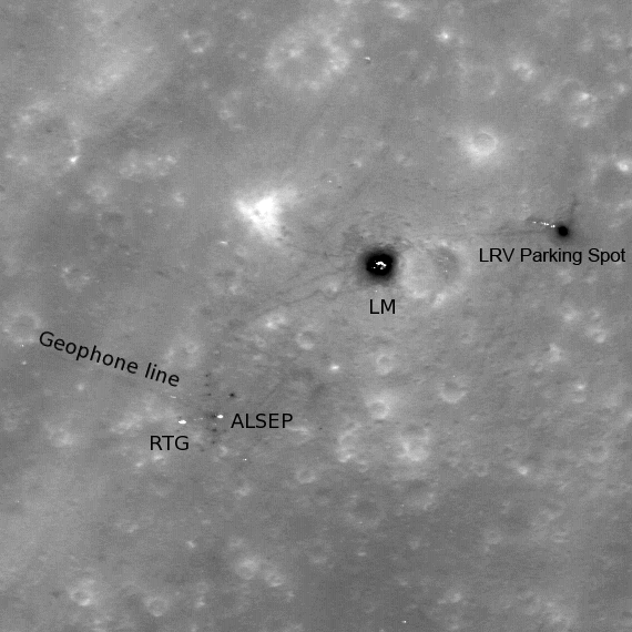
High-sun image of the Apollo 16 landing site showing the lunar module descent stage, various pieces of equipment, and disturbed lunar soil (seen as darker lines and areas) which marks where John Young and Charles Duke traversed in the spring of 1972. LROC image M109134835L, 296 m across [NASA/GSFC/Arizona State University].

Ross Beyer
LROC News System

The lunar module Orion landed in the Descartes highlands of the Moon on 21 April 1972. The Apollo 16 mission targeted a highland region. Originally thought to be a volcanic site, the samples returned by Apollo 16 actually indicated that the highlands of the Moon primarily consist of impact-formed rocks (breccias), a substantial scientific result.

Today's featured image is an LROC NAC image of the Apollo 16 landing site, acquired when the Sun was nearly overhead, in contrast to our previous image of the site. High Sun causes white and metallic artifacts left on the surface by Young and Duke stand out in high contrast as they reflect the noon-day sun back at LROC. The Apollo 16 astronauts churned up the lunar soil (regolith) as they moved about exploring the Moon, and this disturbed material shows up as dark lines and patches. Since the astronauts spent a fair amount of time around the Lunar Module during their three extra-vehicular activities, the bright lunar module appears to have a dark halo. The same dark halo appears around the parked rover. The labels on the image are for the Lunar Module (LM), the Lunar Roving Vehicle (LRV), the Apollo Lunar Surface Experiments Package (ALSEP), the Radioisotopic Thermoelectric Generator (RTG) that powered the ALSEP, and a line of geophones that extended W by NW from the ALSEP station.


LROC Wide Angle Camera monochrome mosaic of the Cayley plains (smooth areas) and Descartes mountains surrounding the Apollo 16 landing site (arrow indicates approximate position of the lunar module). Image M116215423M (full image scene HERE) width is 65 km [NASA/GSFC/Arizona State University].

The Constellation program identified this location as a region of interest because many important scientific questions will be answered by returning here. For example, like other Apollo landing sites, the artifacts left at the Apollo 16 site provide a record of space weathering at the site since 1972. Various planned (and accidental) long duration exposure experiments (like NASA's Long Duration Exposure Facility, experiments on Mir, etc.) have been studied, but all of these have been from facilities in low Earth orbit. Studying what decades of exposure to the lunar environment does to hardware will provide key inputs to engineers designing future systems to operate for long periods in extra-terrestrial environments (Moon, asteroids, Mars).


Apollo 16 lunar module pilot Charles Duke took this photograph out of Cmdr. John Young's window as part of a panorama of their landing site, April 21, 1972. The geological importance of South Ray crater has grown in the years since investigator's initial disappointment at not immediately seeing the evidence of volcanism that had brought them to the location. The crew detected the strongest magnetic fields of any in the Apollo program. Stone Mountain, whose lower elevations Young & Duke would explore during their second EVA, is the northwestern edge of the Descartes formation. In low orbit 27 years later, Lunar Prospector would co-relate the strongest magnetic anomaly on the Moon's near side with the bright, apparently low optical maturity of a swirl, centered on the northern rim of Descartes crater, only 65 km away [NASA/ASJ/AS16-113-18300].


Cmdr. John Young set down Apollo 16 lunar module Orion onto the western rim of a very worn and therefore nearly invisible crater. What had not been immediately apparent until after he disembarked and surveyed their position soon after beginning their first EVA turned out to be a very distinctive identifier when LRO investigators located the Orion descent stage in narrow angle camera images 38 years later [NASA/ASJ/AS16-113-18329].


Charles Duke swept up their "little home" on the Moon, with Palmetto crater and North Ray (not seen in this crop) in the background in one of their spectacular panoramas from Station 4, high on the face of Stone Mountain, during EVA 2 [NASA/ASJ/AS16-112-18269].


To illustrate the stark differences in appearance of lunar locales from overhead, in high and low illumination, two LROC narrow-angle camera observations (M119754107, phase angle = 34.77° - LRO orbit 2781, February 2, 2010 and the Featured M109134835L, phase angle = 7.76° LRO orbit 1217, October 2, 1009) are seen here superimposed on a baseline Apollo metric model, along with selected Apollo 16 station sites. North and South Ray craters take on their bright features familiar to telescopic observers on Earth. The long streamers of South Ray even pass completely over the Apollo 16 landing site. Without the depth of field made possible in long shadows of a low sun, landmarks like Palmetto and Gator craters, and even Stone Mountain, seem to disappeared completely [NASA/GSFC/Arizona State University].


For comparison, in the long shadows of an early morning LROC NAC observation M116215545 (phase angle = 93.22° - LRO orbit 2260, December 23, 2009) caught up the still-intriguing Descartes landing site landmarks while those bright features of North and South Ray (and "Baby Ray") take their turn at being nearly impossible to see [NASA/GSFC/Arizona State University].

The Apollo 16 site also provides access to highlands regolith and rocks; highlands rocks make up about 70% of the lunar surface, and this landing site would be a great place to gather additional samples that would help us characterize the materials that comprise the majority of the lunar surface.

Browse the full-resolution NAC image here!

For more information on LROC's observation campaign for the Constellation program regions of interest read this Lunar and Planetary Science Conference abstract, and visit the LRO Science Targeting Meeting website (look for the baseball card summary sheets for each site: part 1, part 2).

LOLA's Jackson Crater


Bright rays streak for hundreds of kilometers across the lunar surface, originating from a large (70 km-diameter, or ~43 mile-diameter) impact crater in the far side's northern hemisphere. Jackson crater's rays are prominent in visible images, as the rays are made from brighter (or higher-albedo) material than the darker lunar regolith that they overlie. Because they are very thin, they do not appear in LOLA's topography data. What you can see in the elevation data is the morphology, or shape, of Jackson's main crater. The bright reds in along the southeast rim highlight the section with the greatest elevation; the western half of the crater rim is much more subdued.


Looking south from the interior of Jackson crater, looking due south toward the lofty south rim, over the blocky central peak complex; aspects of Jackson properly photographed at last, early in the Commissioning of the Lunar Reconnaissance Orbiter mission. LROC Narrow Angle Camera observation M103223791, from 141.66 km in LRO orbit 381, July 26, 2009 [NASA/USGS/JAXA/GSFC/ASU].

The highest portion of Jackson crater's rim reaches 3.3 km, 2.8 km above the lowest elevation on the crater floor. Terraces step downwards into the crater's interior. One place this is particularly evident in this image is in the west - try tracing along the highest portion of the rim (in the orange color), and then find another series of peaks that outline a terrace ridge (in the green color) just inside the crater. The northwest and eastern sections of the rim are somewhat unusual, as they are relatively straight.

Jackson crater is named after the Scottish astronomer John Jackson (February 11, 1887-December 9, 1958).

+ View Image | + High Resolution

Thursday, July 8, 2010

Rima Birt and Rupes Recta


Cobra's Head of Rima Birt - An uncorrected montage of the left and right frames of LROC Narrow Angle Camera observation M177555153 (Resolution = 67 cm per pixel, from 42.1 km; LRO orbit 2457, January 8, 2010). One of two Lunar Reconnaissance Orbiter Camera (LROC) NAC images in the Second Release to the Planetary Data System that put a new and extraordinary light on a familiar Near Side feature and its surroundings. The observation above, of the cobra head of Rima Birt was imaged in the local evening Sun, only 8 degrees above the western horizon and making the interior of the Rima appear deceptively deep. The distance from the eastern edge of that interior shadow and the feature rim to its east (right) is approximately 800 meters [NASA/GSFC/Arizona State University].

We're grateful to Chuck Wood once again, erstwhile curator of Lunar Picture of the Day (LPOD) for being first to call our attention to the latest, now relatively rare, addition to the Kaguya Image Gallery.

On Wednesday, July 7, under the headline "Wow," Chuck linked to a JAXA MPEG calling it "a remarkable digital flyover of the Straight Wall area" of southeast Mare Nubium.

Though previously available via the JAXA Channel on YouTube, the MPEG rendition of Terrain Camera data gathered by Japan's first lunar orbiter provides better resolution, and it's just as breathtaking.


JAXA (Kaguya/SELENE-1) Terrain Camera and laser altimeter data made possible this virtual view south along the long length of Rupes Recta, part of a remarkable video flyover tour of the area released to the Kaguya Image Gallery, July 5, 2010. The rim of 17km diameter Birt crater rises above the west plain, dominating the southern horizon [JAXA/SELENE].


For scale, the Cobra Head of Rima Birt at the top of this posting can be seen here at center left, in this view from Japan's SELENE-1 lunar orbiter over southwest Mare Nubium. Immediately to east of Rima Birt is 17 km Birt crater, with it's relatively steep slopes supporting Birt A. On the right is the 134 km Rupes Recta, the "Straight Wall." The first HDTV camera to orbit the Moon also flew on Kaguya that swept up more than one outstanding view of the area. Late mission Kaguya HDTV showed the region from progressively lower orbits.

Chuck Wood, author of The Modern Moon: A Personal View (Sky Publishing, 2004), is to be congratulated for reminding us to search through the recent Second Release of LROC images to look for any LRO Narrow Angle Camera close-ups of Rupes Recta, the famous "Straight Wall." A search after the First Release in March turned up nothing, other than preliminary unformatted Wide Angle Camera sessions.

Despite their very real scientific value, their precision and beauty, LROC Wide Angle Camera observations are worth waiting for.

The Rupes Recta region, near the center of the Near Side as seen from Earth, is among the most observed and photographed areas of the Moon. Few are the amateur astronomers on Earth, usually after acquiring their probably more powerful second telescope, who hasn't marveled at their first naked eye view of "Huygens' Sword," or "the Railroad," the 134km long, 490 meter high rift, roughly centered 22.1°S, 352.2°E.


Le Mur droit - An example of the quality of "amateur" photographs of Straight Wall region, as seen from Earth. The area was the subject of "Ancient Thebit and Huygens' Sword," by Charles A. Wood, Sky & Telecope [LPOD/January 11, 2004]..


Our second search of the PDS uncovered two strategically placed LROC Narrow Angle Camera observations, extreme close-ups of noted features, in the vicinity of the Straight Wall (leaving us hungry for more).

Each was gathered in the First Quarter of 2010, and were therefore among those observations in the Second Release of LRO photograpy from LRO announced by LROC principal investigator Marc Robinson, June 21.

One is of the southern half of Rima Birt, and it provided the montage at the top of this post. The cobra head feature can be compared with other less-detailed views of this feature in this post. A second image, viewed in a high sun, has the relief in the long shadows of early morning and late afternoon, slices directly through the Wall's center.


An angled slice through the heart of the Rupes Recta, under a higher Sun (f=33.44° in LRO orbit 3151, March 3, 2010). The 700 meter crater at center predates the rift, and it may have witnessed a gentle transition to its present state. The bright feature on it's eastern interior (see below) is a slide of material once on it's east rim, material originally deep below the progenitor impact's center. Yet another opportunity presents itself for future geologists to take advantage of a ready-made excavation [NASA/GSFC/Arizona State University].

From Lunar Pioneer 4
A closer look at the crater straddling the Straight Wall at 21.6°S, 352.2°E, The character of each half of the plain divided by the rift appears to be similar. Also, at this point in the montage consisting of the right and left frames of LROC NAC M122264663, their overlapping fields of view are joined very close to the location of the rift, so subtle differences in hue might be mistaken for a true appearance [NASA/GSFC/Arizona State University].

Preliminary, low-resolution LRO laser altimetry (LOLA) data clearly picks up the half-kilometer difference in elevations of the plain on either side of Rupes Recta [NASA/GSFC].

Searching for the Moon's Mantle

Red symbols on this map of lunar crustal thickness show where the Kaguya team have identified deposits of olivine [JAXA/SELENE].

Paul D. Spudis
The Once & Future Moon
Smithsonian Air & Space Blogs


We’ve studied and examined the Apollo samples of the lunar maria (pronounced MAR-ee-uh) for thirty years but despite the thorough search of these collections, we have never found a sample of the deep mantle from which these lavas were formed. How might such a deeply seated rock find its way to the surface? Large basin-creating impacts on the Moon might have dug through tens of kilometers of crust (down into its deepest layers) to excavate samples of the mantle. Another occurrence of mantle samples is as small chunks of rock included in lava. Fragments of rock may be ripped away during the ascent of the dense, liquid magma and become inclusions in the solidified lava flows; these “stranger” rocks are called xenoliths. Despite an exhaustive search of the Apollo samples, no samples of the mantle have been found, either as a fragment of basin ejecta or as a xenolith in the mare basalts.

If no one has ever seen it, how do we know what the lunar mantle looks like? The properties and composition of planetary interiors are inferred by indirect evidence. Seismometers left on the surface by Apollo crews measured the velocity of seismic waves inside the Moon, an indirect measure of the density of the deep interior. The density of the mantle is high enough so that common surface rocks cannot make up a significant portion of it; the rocks must contain large amounts of the minerals olivine and pyroxene. In addition, the mantle rocks were partially melted to make the mare basalts that cover the surface in places. The chemical composition of these lavas show they were made by melting a rock rich in magnesium and iron. Finally, xenoliths of the Earth’s mantle are sometimes found entrained in lavas – these pieces are made up of the olivine-pyroxene rock peridotite (after the mineral olivine (the gem form is peridot) that makes up most of it.) So the idea that the rocks of the mantle are olivine-rich is a well-grounded concept for which we have abundant independent evidence.

Now a new scientific paper concludes that fragments of the mantle (the dense magnesium- and iron-rich portion of the Moon that lies below 70-100 km depth) are exposed on the surface, brought up from depth by the impact of giant asteroids 4 billion years ago. Such a finding would indeed be significant, as geologists always seek rocks from the deep interior to aid our understanding of the Moon’s structure and composition. Data from the orbiting Japanese Kaguya mission shows that olivine is present in the surface deposits of some lunar craters. But how do they go from this observation to the interpretation of lunar mantle? Basically, they mapped out the occurrences of these olivine deposits and found that many of them occur within the rims of large impact basins. Based on models produced from gravity mapping, the crust of the Moon is thought to be thin here and the mantle is close to the surface. Thus, these large impact basins could have excavated chunks of the mantle, throwing them out onto the surface of the Moon.

Why is the mineral olivine important? Olivine is a silicate mineral rich in magnesium and iron; it forms one of the basic, silicate building blocks of the rocky planets. In magma (liquid rock), olivine crystallizes first and its composition is a key indicator of the composition of the magma. Current prevailing wisdom is that the early Moon was largely molten (the “magma ocean” phase); whether it was completely molten or merely liquid in its outer portion is uncertain, but in such a huge system of liquid rock, olivine is the earliest mineral that crystallizes. Being dense, crystallizing olivine would sink in the liquid magma, slowly accumulating deep in the Moon. As the entire Moon solidified, these “cumulate” layers of olivine and other iron-rich minerals would make up the mantle. Later, the mantle partially re-melted, creating liquids that erupted onto the surface as basalt lava and formed the dark lowland plains – the maria.

So how does the Kaguya interpretation hold up on examination? Estimates of crustal thickness are of the current Moon, after the basins formed. There is no particular reason to suppose that a given basin-forming impact occurred in terrain of thin crust – the crust is thin here because the basin formed. True enough, some of these impact features are very large – the Imbrium basin, a large crater on the western near side, is well over 1000 km in diameter, large enough to have punched through the thickest sections of the crust, one would think. Indeed, Imbrium is one of the sites that the Kaguya team propose as having excavated mantle. So they are finding these areas in the places where one might expect to find them.

Olivine is a very common mineral and abundant in the lunar crust. A curious fact is that olivine grains in lunar highland rocks tend to have high amounts of calcium, a minor element but a key diagnostic of the crystallization environment. In Earth rocks, olivine formed at depth has very low concentrations of calcium. My colleague, the late Graham Ryder concluded that the olivine crystals in dunite (a rock made up almost completely of olivine) from the Apollo 17 site – a sample proposed as a piece of the lunar mantle – likely came from the accumulation of crystals at a depth of only a few kilometers, far shallower than the tens of kilometers depth to the mantle.

Because the Kaguya spectral mapper is detecting only the presence of olivine, we cannot distinguish between pure olivine and olivine crystallized with plagioclase, what lunar scientists call troctolite. Troctolite is common in the Apollo highland samples, but is a relatively rare rock on Earth. It consists of (more or less) equal parts olivine and plagioclase, a calcium- and sodium-rich silicate mineral. Troctolites make up some of the most deeply derived rocks found in the Apollo collections, but all studied to date seem to be of crustal, not mantle, provenance. There is no objective evidence that the olivine seen by Kaguya is not derived from troctolites and/or dunites of crustal (not mantle) origin.

The long held desire of lunar scientists to sample deeper levels of the Moon is understandable, but we must proceed cautiously. Just as a sample return mission to the floor of the largest basin on the Moon is no guarantee that we will obtain the rocks needed to answer questions about early cratering history, the new finding of abundant olivine on the Moon does not mean that pieces of the mantle are lying on the surface, awaiting collection by some future mission. The Kaguya findings are intriguing and very interesting, but not definitive evidence for the presence of mantle fragments on the lunar surface.