Saturday, September 7, 2013

LADEE legacies

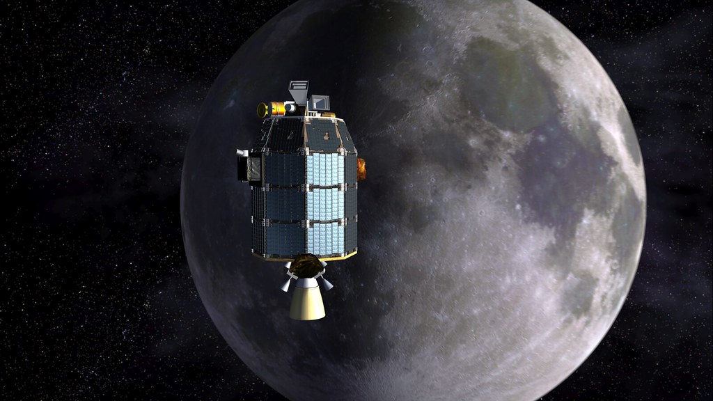
LADEE approaches lunar orbit insertion
In planning since 2008, LADEE's reason-for-being emerged from mapping science goals believed essential before any permanent manned presence on the Moon's surface could begin. Fortunately, like LRO, LCROSS and GRAIL, planning and development were well underway and within budget when Congress eventually scrubbed the Constellation brand and manned Altair lander [NASA].
Like "The Blind Men and the Elephant" the most important moving part of many riding along with LADEE to the Moon very much depends on your personal perspective.

What might seem a low-priority mission, accompanied by an appropriate degree of "hype," and has modest fundamental goals under the banner of experimental modular designs and revolutionary high speed communications, - only a 100 day science mission, LADEE has been in development for more than five years. The advanced vehicle also carries with it hopes of some that go back nine times that period, covering a lot of political ground and many changes, even over the relatively short time since its framing and approval.

Gene Cernan's Dusty Spacesuit
Gene Cernan (by Harrison Schmitt) at the close-out of the third and final EVA of Apollo 17, and the last manned visit to the Moon in December 1972. The commander's spacesuit is blackened by exceeding fine lunar dust, more than just a problem of appearances, a real hazard that might have caused hatch and spacesuit seals to fail on a longer surface mission. Constellation planners understood they needed to get a handle on mitigating the hazard posed by omnipresent dust while also gaining an better understanding of the dynamics of a primal airless Moon and its surface before humans return to stay [NASA/JSC].
Few watching the LADEE/Minotaur V launch, critical for Orbital Sciences Corporation, from Wallops Island, are likely to be reminded that the mission owes its existence to the catastrophic loss of Space Shuttle Challenger ten years ago. But it is possible to appreciate the things NASA logically wants emphasized without forgetting LADEE is the beginning of the end of the defunct Constellation program that so many wanted dead and buried in 2009.

LADEE is the last of the unmanned precursor missions once believed essential before "extended human activity" on the Moon could begin. The absolutely remarkable Lunar Reconnaissance Orbiter (LRO) will likely still be orbiting the Moon for a few years after LADEE's mission-terminating guided impact a few months from now, but none of these 21st century American unmanned lunar missions are likely to have have occurred before today without the initial political will put in motion after the report of the Challenger Accident Investigation Board (CAIB).

LRO, LCROSS, GRAIL and now LADEE each owe their reason for being to the loss of a second Space Shuttle and crew in 2003.
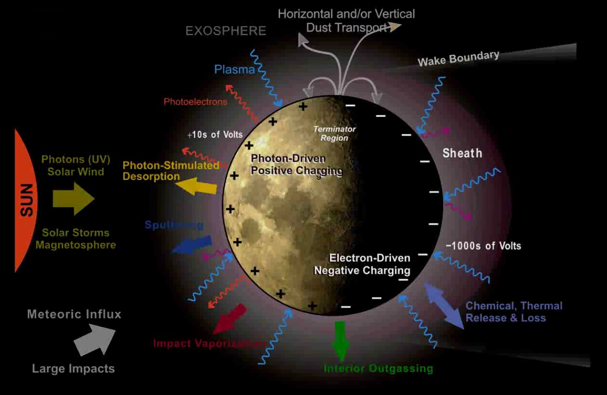
LADEE Slides (LEAG 2011 Lunar Exosphere Model (After Halekas))
Very simple schematic of the lunar exosphere. The Moon's surface turned out to be a very dynamic place, after all, with water and exotic metals and volatiles trapped in permanent shadow and also hiding in plain sight [Halekas/LEAG/NASA].
If you've seen the movie footage of Neil Armstrong immediately after setting that first boot on the Moon, backing away from the ladder tethered to the spacecraft then you may have guessed there once was real fear that he might just suddenly disappear in a bog of dust.

Such concern had mostly been dispelled by July 1969, though, after none of the successful unmanned Surveyor landers had encountered anything other than a hard-packed lunar surface. And yet the Moon was correctly presumed to be a very dusty place, constantly "gardened" by micrometeorites (and some not so micro) together with energetic cosmic and solar radiation. Without direct samples, however, no one correctly guessed just how "fine" the dusty powder on the lunar surface could be.

By the time Gene Cernan climbed back into the Apollo 17 lunar module in late 1972 at the end of the program another hazard from this dust had become apparent instead. Rather than sinking into feathery banks of fluffy snowbanks astronauts had to deal instead with a film of electrostatic-charged, clinging and microscopic glassy razor blades. It smelled like gun powder and got into everything, and seemed impossible to clean.

The dark dust of the Moon's immediate surface threatened hatch seals, it scared and tore into spacesuits and, following EVA close-outs became lodged in every conceivable place on an astronaut's body, including up their noses, in their lungs and also lingering in their softest places.

Clearly, "dust mitigation," by then long acknowledged as a real mission and health hazard, came forward as a priority science goal when before new lunar surface expeditions could be carried out. It is accepted as a similar threat to manned travel to Mars, and to the asteroids.

All models of what has become known as a "dynamic" rather than "static" lunar surface include production and trapping of volatile compounds once thought essentially non-existent on the Moon. The speed of this production, it's true dynamics, badly need to be studied before we can return to the Moon with impunity.

Every time an unmanned spacecraft (or a manned lunar module) has landed or taken off from the Moon it's certain some of the dust propelled away by exhaust reaches escape velocity. A larger part of this spiny cloud is put into orbit or on a ballistic path carrying these particles all over the lunar surface. LADEE is designed to establish some natural baseline for this dust before humans start stirring things up. The impact of spacecraft is comparable to the occasional larger natural impact, but hot gas exhaust and its effects is something new.
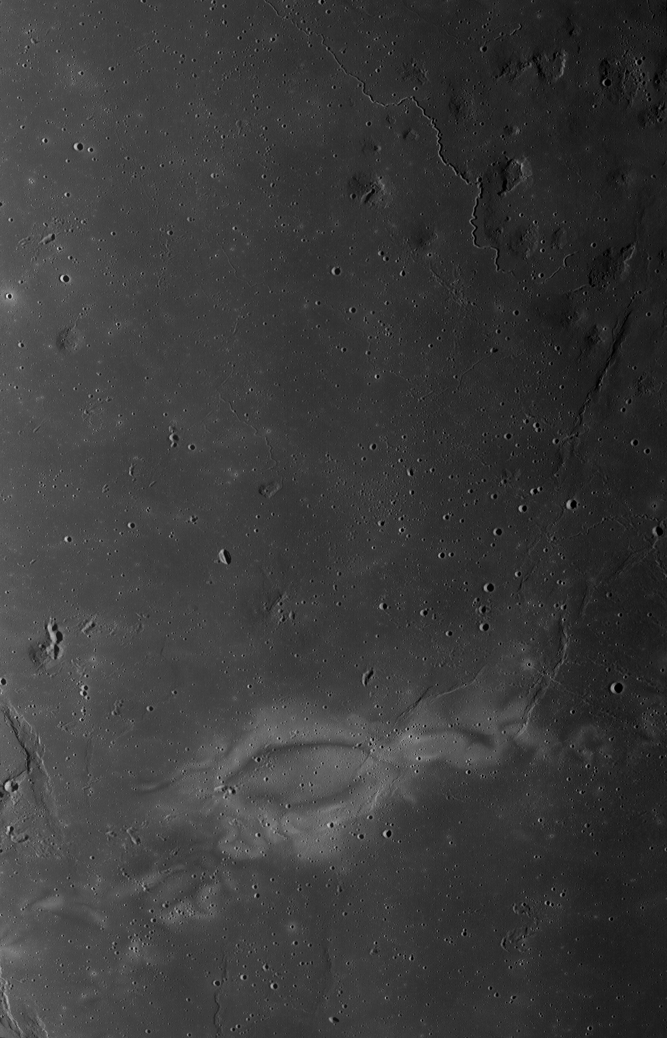
Painted On Procellarum
The delicate bright dust lanes of the Reiner Gamma "swirl albedo" phenomena, stretching at least 550 km southwest from the dormant volcanic Marius domes to the western frontier of Oceanus Procellarum. Seen here in an LROC WAC mosaic from 2010 under early morning shadows. Detailed laser altimetry confirms little to no topographic component, though it does closely correlate with a well-mapped anomalous crustal magnetic field that must be older than exposure to the Sun and space weathering would allow the surface here to remain so bright. Migration of dust, alternately charged and discharged, dislodged by micro-bombardment is alternately attracted and repelled, here, by the local magnetic field lines, keeping the new dust constantly renewed and gathered no more than a meter or so deep [NASA/GSFC/Arizona State University].
Whether or not this was really a guesstimate or hard science, by the time Congress seriously committed to return to the Moon to stay investigators had acknowledged that a kind of primal state existed there that was worth scientific study for its own sake, before human engaged in any "extended activity." And herein is the compelling interest for funding the LADEE mission. It's one way of discovering the state of the lunar exosphere, its dynamics in and out of Earth's extended magnetic field, under a traveling solar incidence, and through a good sampling of lunar days and nights before things inevitably get busy.

The hyperfast laser-based communications and modular spacecraft design for LADEE will be much talked about in reports about this mission, over the next few days and months. That's "all good," as they say, but it might be worth it to also remember the mission's origins going back before Surveyor or Apollo and also offer at least some thanks to the crew of Columbia. We owe the recent renewed short burst in lunar exploration and our added knowledge of the Moon directly to the loss of that spacecraft and crew.
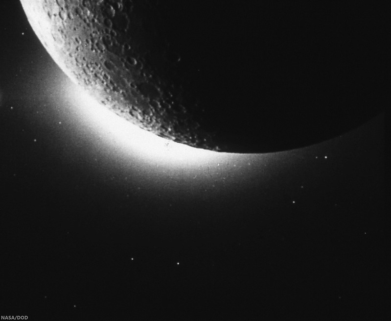
Lunar Horizon Glow from Clementine (1994)
Another lunar mission (and one of only two American missions to the Moon between 1972 and 2009) was also justified as a test platform for new technologies. Now "lost and gone forever," Clementine (1994) spent a year in lunar orbit operated by both NASA and the U.S. Department of Defense. Here Clementine's star-tracking camera finally definitively photographed the "horizon glow" caught previously in the lunar night from the surface by Surveyor 7 and described by Apollo astronauts in lunar orbit twenty years before. This is the phenomena, believed to be back-lit lunar dust, that LADEE is designed to directly sample [NASA/DOD].
And whenever humans eventually return to the Moon for their inevitable extended stay, they will owe much of their preparation to that spacecraft and crew.

Related Posts:
LADEE Prelaunch Mission Briefing (September 6, 2013)
ESA prepares for LADEE (July 31, 2013)
LADEE arrives at Wallops Island (June 5, 2013)
LADEE ready to baseline dusty lunar exosphere (June 5, 2013)
First laser comm system ready for launch on LADEE (March 16, 2013)
LADEE project manager update (February 6, 2013)
The Mona Lisa test for LADEE communications (January 21, 2013)
Toxicity of lunar dust (July 2, 2012)
Expectations for the LADEE LDEX (March 23, 2012)
The Dust Management Project (August 9, 2010)
LADEE architecture and mission design (July 6, 2010)
DesertRatS testing electrodynamic dust shield (July 5, 2010)
Dust transport and its importance in the origin of lunar swirls (February 21, 2010)
Dust accumulation on Apollo laser reflectors may indicate a surprisingly fast and
more dynamic lunar exosphere
(February 16, 2010)
NASA applies low cost lessons to LADEE (January 18, 2010)
Nanotech advances in lunar dust mitigation (August 19, 2009)
Moon dust hazard influenced by Sun's elevation (April 17, 2009)
LADEE launch by Orbital from Wallops Island (April 14, 2009)
Understanding the activation and solution properties of lunar dust
for future lunar habitation
(March 2, 2009)
Respiratory toxicity of lunar highland dust (January 19, 2009)
Toxicological effects of moon dust (June 25, 2008)
Moon dust and duct tape (April 22, 2008)

Friday, September 6, 2013

Thursday, September 5, 2013

Clerke

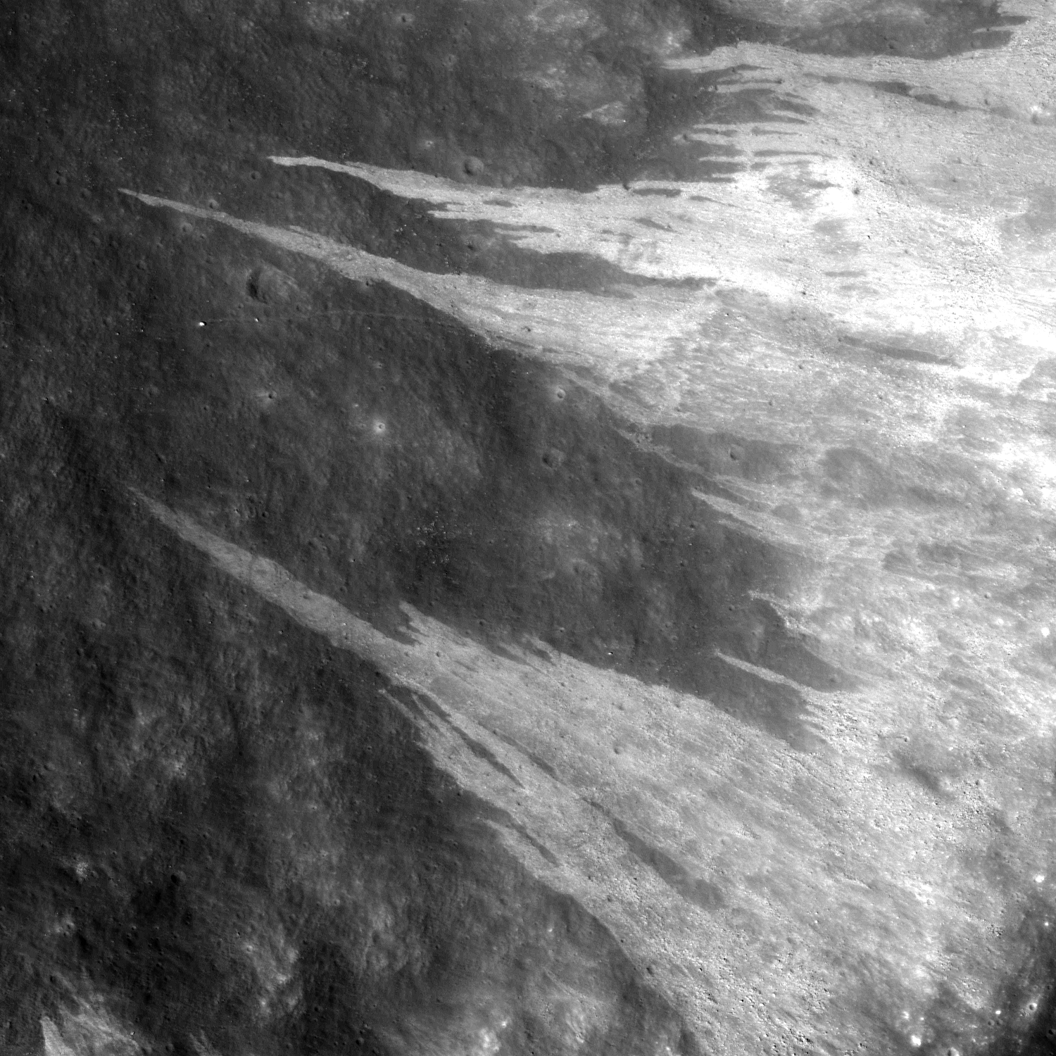
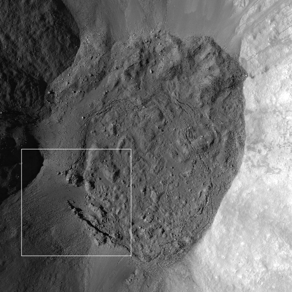
Granular fine falls on the wall of Clerke crater
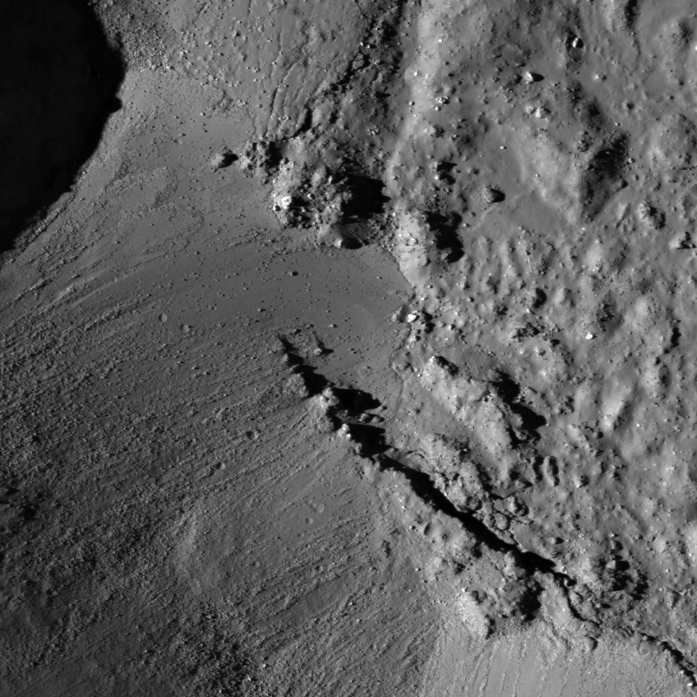
Granular debris flows along the interior wall of Clerke crater, marking a stark contrast in surface reflectance. The crater floor is upper left of this approximately 2 km-wide field of view from LROC Narrow Angle Camera (NAC) observation M183332397R, LRO orbit 12116, February 8, 2012, incidence angle 43.96° full resolution 1.32 meters per pixel from 132.84 km over 20.63°N, 29.76°E [NASA/GSFC/Arizona State University].
Sarah Braden
LROC News System

The interior wall of the Clerke crater has many distinct flows of granular material which narrow as they reach towards the floor of the crater. The source material originates from the crater rim. The debris appear higher in reflectance compared to the rest of the crater wall, likely due to differences in maturity and perhaps grain size of the material.

The debris flows may be younger than the crater floor and walls if the flow was instigated by seismic shaking or a nearby impact crater. The flow may contain more boulders, which may cause the higher reflectance.

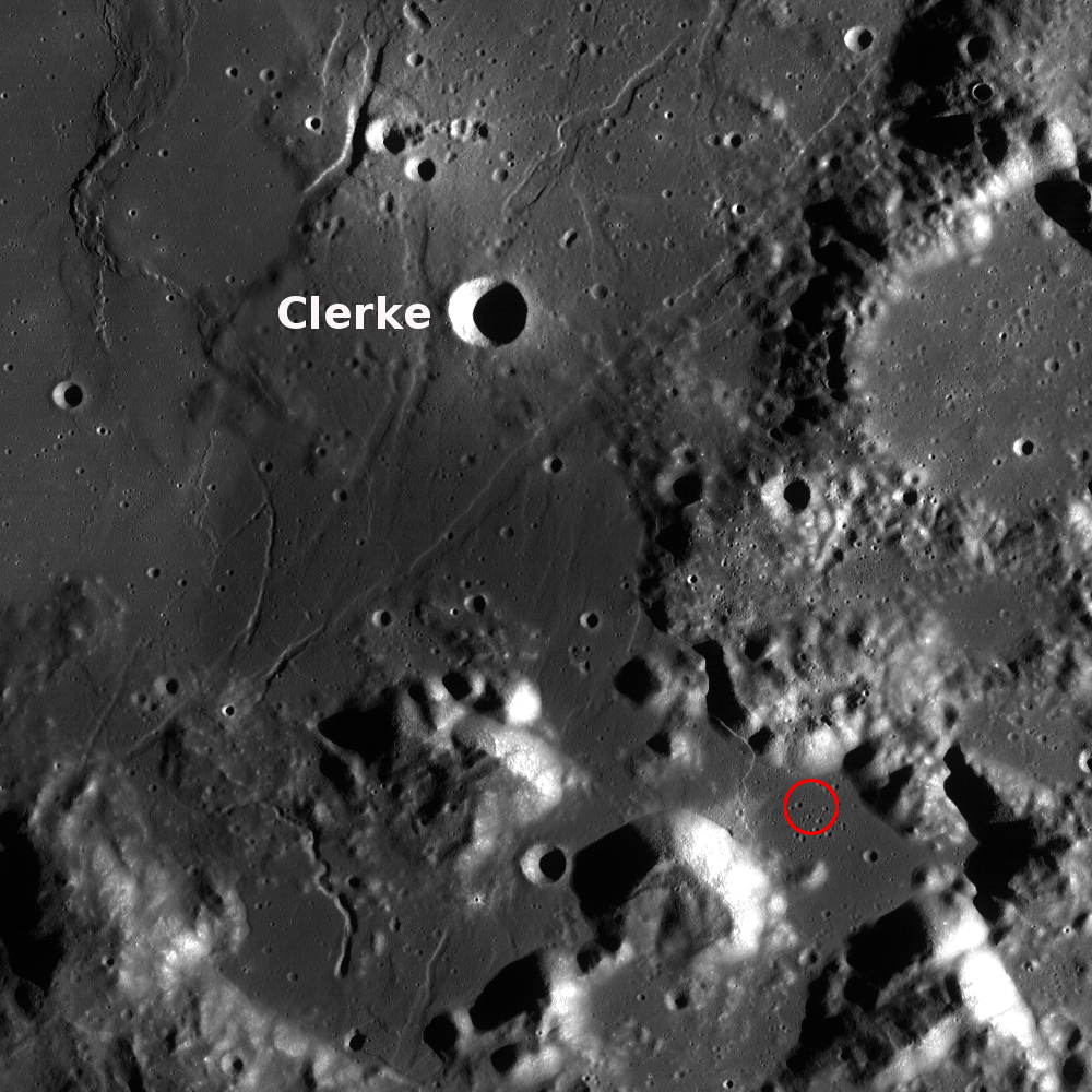
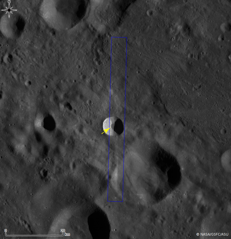
The crater is 7 km in diameter, located at 21.7°N, 29.8°E near the Taurus Littrow Valley where Apollo 17 landed on December 11, 1972 and is named after Agnes Mary Clerke.

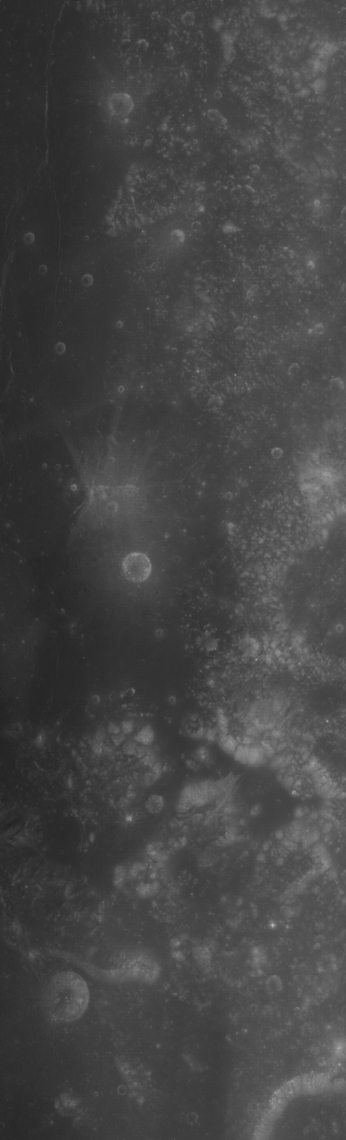
M170361778-8558CE_566nm-Clerke
Clerke under a high Sun, a low illumination angle of incidence (25°), resulting in an image emphasizing surface reflectance over topographic variation. From an LROC Wide Angle Camera (WAC) monochrome (566 nm) mosaic of two sequential orbital observations captured September 11, 2011; average resolution 60 meters per pixel from 41 km [NASA/GSFC/Arizona State University].
Agnes Mary Clerke was key in increasing public interest in astronomy and astrophysics. She wrote the book A Popular History of Astronomy During the Nineteenth Century (published in 1885), which was written for the non-astronomer. This publication brought her recognition from the astronomy community. Later she wrote Problems in Astrophysics which described her ideas on the direction for future research involving the Sun, stars, and nebulae. Ms. Clerke possessed a great ability to synthesize research results, look at the "big picture" of science, and communicate those ideas to the public as well as scientists. She was elected an honorary member of the Royal Astronomical Society, and an award given (at the time) to only three other women: Caroline Herschel, Mary Somerville, and Margaret Lindsay Huggins.

Sunrise topography of Clerke
Alternately, Clerke under a low Sun, and thus a high illumination angle of incidence, resulted in this view of the crater and vicinity in an image greatly emphasizing topographic variation over surface reflectance. LROC GLD100 meter per pixel mosaic, an LROC WAC context showing the proximity of Clerke to the Apollo 17 landing site (red circle) in the Taurus Littrow valley [NASA/GSFC/Arizona State University].
Explore the rest of Clerke crater and the surrounding area in the full NAC, HERE.

Related Images:
Caroline Herschel Crater
How Recent?
Dawes
Dichotomy
Diversity

Tuesday, September 3, 2013

Excavating Dark Deposits

M185955372RE_thumb-580
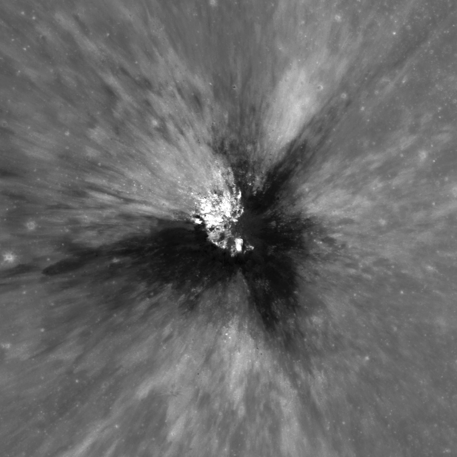
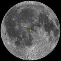
An approximately 250 meter crater has excavated low reflectance material from beneath the lunar surface, west of Sommering P crater, southeast of Copernicus. LROC Narrow Angle Camera (NAC) frame M185955372R; LRO orbit 12483, March 9, 2012; 9.56° angle of incidence, native resolution 1.11 meters per pixel, from 110.79 km over 1.53°N, 249.3°E, field of view 1.8 kilometers [NASA/GSFC/Arizona State University].
Sarah Braden
LROC News System

Amazing ejecta patterns from small, young craters are always something to look at on the lunar surface. Today's Featured Image displays compositional diversity in fresh ejecta. The broad, low-reflectance streaks of material are likely excavated pyroclastic materials. This approximately 250 m diameter crater is located at 2.162°N, 349.401°E, west of the crater Sommering P.

This low-reflectance material is part of a larger area called a Dark Mantle Deposit (DMD). Dark mantle deposits have lower reflectance compared to surrounding mare basalt areas and are also spectrally distinct from mare basalt. In this case, the dark mantle deposit was likely covered by a thin layer of crater ejecta.

Context with Sommering P
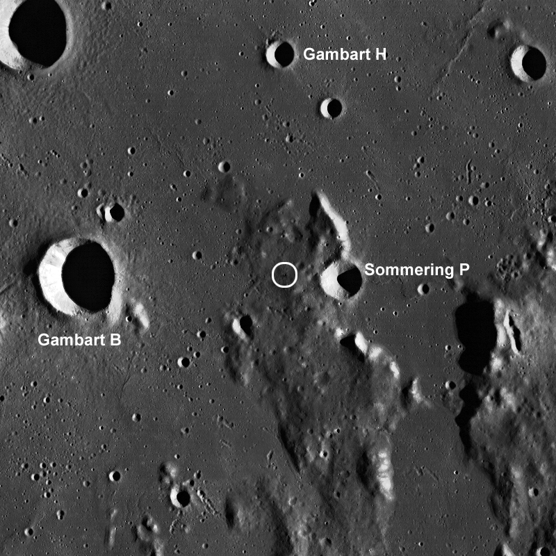
The small crater's location marked with a white circle in an LROC Wide Angle Camera (WAC) context image of a field of view 80 km across [NASA/GSFC/Arizona State University].
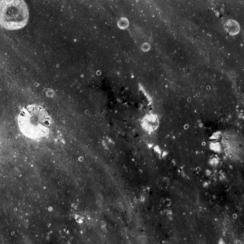
The opening image has a low incidence angle of 10° which means the Sun is high in the sky (near local noon). High-sun images are good for revealing differences in the reflectance properties of the surface. Low-sun (large incidence angle) images are better at emphasizing morphology due to topographic shading and shadowing. Incidence angle is the angle between the vector of sunlight and the vector normal to the surface. The WAC context image above has a large incidence angle (taken in early morning) which makes visible the topographic high where the crater was formed. This topographic high is a remnant of highland terrain (kipuka) surrounded by younger mare basalt deposits (smooth, flat areas). There are many other craters on the topographic high that excavate low-reflectance material, which suggests that the whole area is different from the surrounding mare basalt deposits. The high-sun WAC mosaic (below) of the same area shows the locations where the dark mantle deposit is visible. You can learn more about dark mantle deposits here!

643nm high sun, high-reflectance WAC context
LROC WAC monochrome (643 nm) high sun, high reflectance view of the same area as seen in the WAC mosaic immediately above, resolution roughly 100 meters per pixel. Note darker material around the area of the topographic high place [NASA/GSFC/Arizona State University].
Explore the full NAC image HERE to see the other craters excavating low-reflectance material.

Related Images:
Hyginus Crater and Pyroclastics
Dark Wisps in Copernicus
Polka-Dot Ejecta
Pyroclastic Excavation

Saturday, August 31, 2013

Chang'e-3 officially enters launch phase

Chang'e-2 soft lander deploys first lunar rover in nearly 40 years in this simulation shown on China national television [CNSA].
Zhu Ningzhu
From Xinhua   

"Chang'e-3 has officially entered its launch stage, following its research and manufacture period," said a statement released by the administration after Wednesday's meeting on the mission.

The mission will see a Chinese space probe land on a celestial body for the first time.

"The Chang'e-3 mission makes best use of a plethora of innovative technology. It is an extremely difficult mission, that carries great risk," said Ma Xingrui, head of China's space exploration body and chief commander of the lunar program.

LROC WAC Sinus Iridum Mosaic [NASA/GSFC/Arizona State University]
Sinus Iridum, the "Bay of Rainbows" embayment on the northwestern frontier of Mare Imbrium and likely target for the first soft landing on the Moon since 1976, by China's third unmanned lunar probe Chang'e-3 before the end of 2013. LROC Wide Angle Camera (WAC) mosaic [NASA/GSFC/Arizona State University].
The Chang'e-3 mission is the second phase of China's lunar program which includes orbiting, landing and returning to Earth, following the successes of the Chang'e-2 missions, which include plotting a high-resolution, full-coverage lunar map.

Chang'e-3's carrier rocket has successfully gone through its first test while the launch pad, control and ground application systems are ready for the mission.

Chang'e-3 will be launched from the Xichang Satellite Launch Center in southwest China.

From the Register:

The Chang’e-3 probe, first revealed last year, is a 100kg, six-wheeled rover that will spend three months traversing the lunar landscape under human control. The spacecraft will use the Moon’s gravity to slow down, orbit the satellite, and then soft-land using rocket propulsion.

This will be the first time the Chinese have landed a spacecraft on a non-terrestrial surface and the Chang’e-3 will be a crucial test of both Chinese aeronautics and rocketry control systems. The rover will pave the way for a future manned mission to the Moon, and a possible space colony on the surface.

“The Chang’e-3 mission makes best use of a plethora of innovative technology. It is an extremely difficult mission, that carries great risk,” said Ma Xingrui, head of China’s space exploration body and chief commander of the lunar program.

The first Chang’e probe was launched 2007 and completed a 3D map of the Moon’s surface before being intentionally crashed into the planetoid. Chang’e 2, launched in 2010, carried out further mapping 100km off the Moon’s surface before being directed out to fly by the asteroid Toutatis and is now heading out into the Solar System.

Like NASA’s early rovers on Mars, the Chang’e-3 will be primarily solar powered and will carry a ground-facing radar on its belly capable of penetrating up to 30 meters into the lunar regolith, as well as a alpha particle X-ray spectrometer and an infrared spectrometer.

China plans a manned mission to the lunar surface possibly as soon as 2017 – although he authorities aren’t setting themselves a Kennedyesque deadline and say they’ll go when they are ready. Once there, however, the Chinese government has said it plans to build the first manned lunar outpost, an objective NASA has already abandoned.

Related Posts:

Thursday, August 29, 2013

Rough crater wall surface

M182038126L_thumb-580x1000
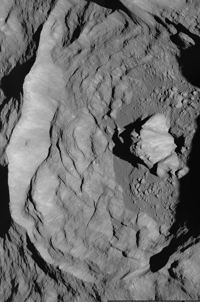
Upper part wall inside an unnamed fresh crater in the southwestern quadrant of farside Hertzsprung basin. LROC Narrow Angle Camera (NAC) observation M182038126L, LRO orbit 11934, January 24, 2012; 56.41° angle of incidence, resolution 1.08 meters per pixel from 107.13 km. Downslope is toward lower right, north is to the top [NASA/GSFC/Arizona State University].
Hiroyuki Sato
LROC News System

The opening image reveals the northwestern portion of the steep wall inside an unnamed young crater (6.8 km in diameter, the same crater in Tuesday's Featured Image). The upper left corner of this image, the relatively smooth part, corresponds to the outer gently sloping surface, and the rest of the image is the interior wall.

This steep surface displays very complicated forms, likely due original flow of impact melt down the walls, perhaps in places modified by small scale collapses. Several spots indicated with arrows show the contact between relatively smooth surface materials, probably impact melts, and sharp craggy edges. Are the smooth parts really impact melt? Or perhaps they are surfaces from which hardened impact melt slipped down. What we do know is that enormous amounts of impact melt were splashed around inside and outside the crater, a violent scene we can hardly imagine. New LROC data is unveiling the nature of impact melts through their shape, texture, distribution, quantity, and spectral reflectance.

LROC WAC M112461899C (604nm) 580x1000
The unnamed crater and surrounding areas in the LROC Wide Angle Camera (WAC) monochrome (604nm) observation M112461899C, spacecraft orbit 1707, November 10, 2009; 39.1° angle of incidence, resolution 86.97 meters per pixel, from 61.69 km over 7.25°S, 227.53°E [NASA/GSFC/Arizona State University].
Explore this fresh and complicated crater wall in full NAC frame, HERE.

Related Posts:
Sinuous Cracks
View From The Other Side
Craggy Peak, Impact Melts
Cracked mound
Waves
Tycho Central Peak Spectacular!

Tuesday, August 27, 2013

Debris over impact melt pool

M182038126R_thumb-580
Debris avalanche covering an impact melt pond inside an unnamed crater floor. From LROC Narrow Angle Camera (NAC) M182038126R, LRO orbit 11934, January 24, 2012, centered on 4.135°S, 227.677°E, angle of incidence 56.58° over a field of view 1083 meters across, resolution 1.08 meters from 107.13 km. Downslope is toward upper right, north is to the top [NASA/GSFC/Arizona State University].
Hiroyuki Sato
LROC News System

Today's Featured Image highlights the southwestern edge of the floor of an unnamed crater (6.8 km in diameter), located in the SW corner of the degraded Hertzsprung basin (540 km diameter). The rough hummocky surface (upper right) corresponds to an impact melt pond, which covers the floor of this crater. The debris avalanches originated from the crater wall and covered the melt pond surface in the lower left. These debris deposits follow the topographic gap along a fracture extending to the lower right from the center of this image, indicating that the fracture formed before the avalanche.

M182038126R_NAC_context-600
The NAC frame as context for the LROC Featured Image (frame), showing the unnamed crater floor in Hertzsprung basin within a 3 km field of view [NASA/GSFC/Arizona State University].
Impact melt ponds usually develop fractures and deformations of their surfaces (e.g. Melt and more melt, Channels And Fractures). The cause and timescale of such modification is unclear and still under discussion (e.g. Ashley et al., 2012) but is likely due to the crater subsurface re-adjusting as the impact melt cooled and hardened. The shape of impact craters slowly evolves over long periods of time. Thanks to the relatively slow erosional processes on the Moon relative to the Earth, we can observe a series of craters from young to very old with NAC images, helping scientists understand the process of crater formation and subsequent modification. 

M182038126R_context-580x599
The unnamed crater and surrounding area in LROC Wide Angle Camera (WAC) monochrome mosaic (100 meter LROC Global Mosaic), centered on 4.02°S, 227.72°E. The NAC frame footprint and the location of Featured field of view are designated [NASA/GSFC/Arizona State University].
Explore the debris avalanche inside this young fresh crater in full NAC frame, HERE.

Related Posts:
More Impact Melt!
The View Inside of a Tilted Crater
Schiaparelli E
Channels And Fractures
Impact melt outside Wiener F
Rippled Pond
Melt and more melt
Vavilov-Hartzsprung-LROCDEMCSHd-064-969
Color shaded LROC digital elevation model shows the small crater in starker contrast not readily visible in pure optical photography (arrow, right of lower center), in the ancient Hertzsprung basin and nearby Vavilov crater. 400 km field of view, orthographic projection from LROC WMS image search map [NASA/GSFC/Arizona State University].

More water at lunar equator, hints of water below

Bullialdus Interior Oblique
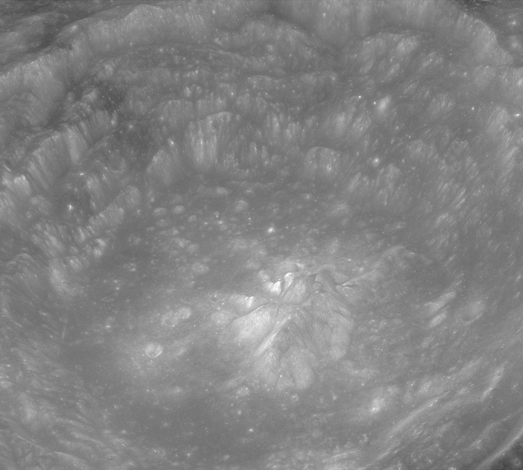
Investigations of the central peaks (where the deepest material these kinds of craters excavate is deposited) of nearside equatorial crater Bullialdus (60.7 km, 20.7°S, 337.8°E) have detected rocks composed of magmatic water of a kind collected by Apollo using the NASA M3 radar instrument aboard the ISRO orbiter Chandrayaan-1. LROC Narrow Angle Camera (NAC) oblique observation M1099038207LR, spacecraft orbit 14313, August 8, 2012; overall resolution 2.4 meters, angle of incidence 48.8° with spacecraft and camera slewed 63.4° west of nadir, 73.65 kilometers over 20.96°S, 331.93°E [NASA/GSFC/Arizona State University].
NASA-funded lunar research has yielded evidence of water locked in mineral grains on the surface of the moon from an unknown source deep beneath the surface.

Using data from NASA's Moon Mineralogy Mapper (M3) instrument aboard the Indian Space Research Organization (ISRO) Chandrayaan-1 spacecraft, scientists remotely detected magmatic water, or water that originates from deep within the moon's interior, on the surface of the moon.

The findings, published by letter, August 25, in Nature Geoscience, represent the first detection of this form of water from lunar orbit. Earlier studies had shown the existence of magmatic water in lunar samples returned during the Apollo program.

M3 imaged the lunar impact crater Bullialdus, which lies near the lunar equator. Scientists were interested in studying this area because they could better quantify the amount of water inside the rocks due to the crater's location and the type of rocks it held. The central peak of the crater is made up of a type of rock that forms deep within the lunar crust and mantle when magma is trapped underground.

"This rock, which normally resides deep beneath the surface, was excavated from the lunar depths by the impact that formed Bullialdus crater," said Rachel Klima, a planetary geologist at the Johns Hopkins University Applied Physics Laboratory (APL) in Laurel, Maryland.

"Compared to its surroundings, we found that the central portion of this crater contains a significant amount of hydroxyl - a molecule consisting of one oxygen atom and one hydrogen atom -- which is evidence that the rocks in this crater contain water that originated beneath the lunar surface," Klima said.

LROC Wide Angle Camera (WAC) 100 meter per pixel mosaic of Bullialdus, an illustration for the post "Bullialdus Central Peak Oblique," January 23, 2013 [NASA/GSFC/Arizona State University].
In 2009, M3 provided the first mineralogical map of the lunar surface and discovered water molecules in the polar regions of the moon. This water is thought to be a thin layer formed from solar wind hitting the moon's surface. Bullialdus crater is in a region with an unfavorable environment for solar wind to produce significant amounts of water on the surface.

"NASA missions like Lunar Prospector and LCROSS (the Lunar Crater Observation and Sensing Satellite) and instruments like M3 have gathered crucial data that fundamentally changed our understanding of whether water exists on the surface of the moon," said S. Pete Worden, center director at NASA's Ames Research Center in Moffett Field, Calif. "Similarly, we hope that upcoming NASA missions such as the Lunar Atmosphere and Dust Environment Explorer, or LADEE, will change our understanding of the lunar sky."

Combined data for the Bullialdus area
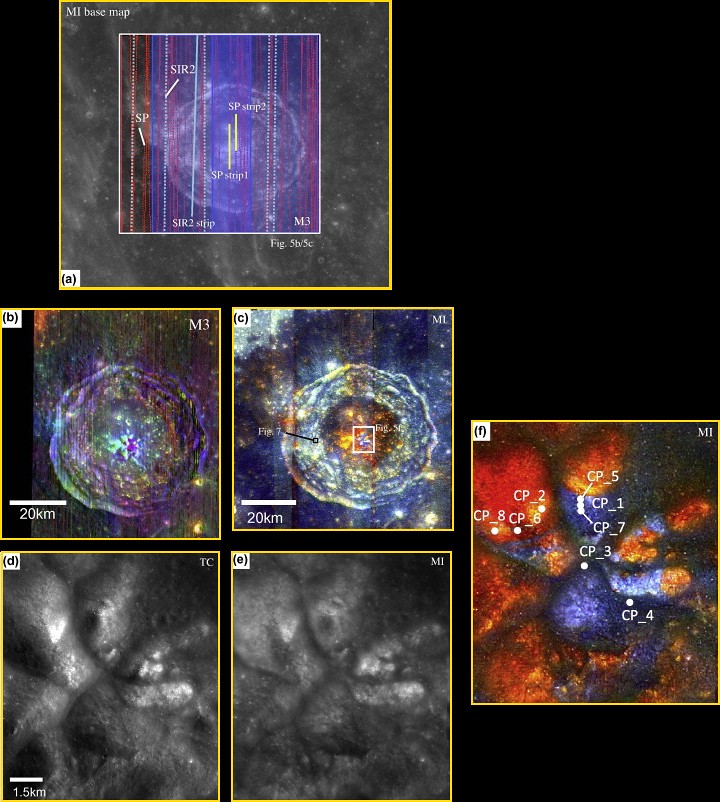
Figure 5 from "One Moon, Many Measurements 3: Spectral reflectance," Science Direct (Icarus, Vol 226, #1, Sept.-Oct. 2013) Combined data for the Bullialdus area. (a) Location of available datasets of the Bullialdus region: gray scale base map, MI; red dots, SP traverses; blue shading, M3 scene width; light-blue dots, SIR-2 traverses. SP/M3/SIR-2 datasets within the white box are presented in this figure. The white box corresponds to the area shown in (b) and (c). TC data cover the entire area. Data included in Table 2 for SP are indicated in yellow, and those for SIR-2 are solid light blue. (b) M3 color-composite image. Band assignments are integrated band depth at 1 μm (red), integrated band depth at 2 μm (green), and 1.5 μm albedo (blue). A manual shadow mask has been applied, primarily on the west (left) crater wall. (c) MI color-composite image. Red denotes the continuum-removed absorption depth of 0.95 μm, green denotes that of 1.05 μm, and blue denotes that of 1.25 μm. (d) TC image of the central part of the Bullialdus central peak. (e) MI 750 nm-band image after photometric correction using local topographic information. (f) MI color-composite image of the center of the Bullialdus central peak. (For interpretation of the references to color in this figure legend, the reader is referred to the web version of this article.)

The detection of internal water from orbit means scientists can begin to test some of the findings from sample studies in a broader context, including in regions that are far from where the Apollo sites are clustered on the near side of the moon. For many years, researchers believed that the rocks from the moon were bone-dry and any water detected in the Apollo samples had to be contamination from Earth.

"Now that we have detected water that is likely from the interior of the moon, we can start to compare this water with other characteristics of the lunar surface," said Klima. "This internal magmatic water also provides clues about the moon's volcanic processes and internal composition, which helps us address questions about how the moon formed, and how magmatic processes changed as it cooled."

APL is a not-for-profit division of Johns Hopkins University. Joshua Cahill and David Lawrence of APL and Justin Hagerty of the U.S. Geological Survey's Astrogeology Science Center in Flagstaff, Arizona co-authored the paper.

NASA's Lunar Advanced Science and Engineering Program, the NASA Lunar Science Institute (NLSI) at Ames and the NASA Planetary Mission Data Analysis Program supported the research. NLSI is a virtual organization jointly funded by NASA's Science Mission Directorate and NASA's Human Exploration and Operations Mission Directorate in Washington, to enable collaborative, interdisciplinary research in support of NASA lunar science programs.

Friday, August 23, 2013

Astronaut's view of Maury and points south

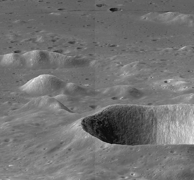
Unusually low LROC NAC oblique of Maury crater and points immediately south
Swooping low over the Maury crater group, dominated by Maury crater (17km, 40.355°N, 41.768°E) in the northern foreground. Distances are deceiving over airless bodies, however.  The crater superimposed on the fault structure running east (left) to west through the south (top) of the full-size 8813 x 8187 pixel field of view is 90 km away from Maury. LROC Narrow Angle Camera (NAC) mosaic M144361170LR, orbit 6408, November 14, 2010; solar illumination incidence angle in the area was 56.21° as the spacecraft  and camera were slewed 76° from nadir, 192 km north of Maury's center (Resolution varies from 1.6 to 9 meters per pixel, from 39.8 km over 43.46°N, 39.82°E) [NASA/GSFC/Arizona State University].
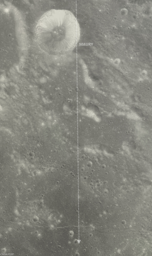
Maury crater - Chang'e-2
Context, medium resolution, low-angle illumination view of Maury and points south visible in the LROC NAC oblique mosaic. The 100 km-long dotted line running south from the top of the image correlates with the overlapping junction between the left and right frames seen up the middle of LROC NAC oblique mosaic M144361170LR. Chang'e-2 image and Clementine natural color matched up in Virtual Moon Atlas 6 [CNSA/CLEP].
Context for oblique LROC NAC mosaic of Maury
LROC WAC global mosaic, hemispheric context with the approximate field of view of Maury crater and vicinity visible in LROC NAC M144361170LR designated at center [NASA/GSFC/Arizona State University].

Thursday, August 22, 2013

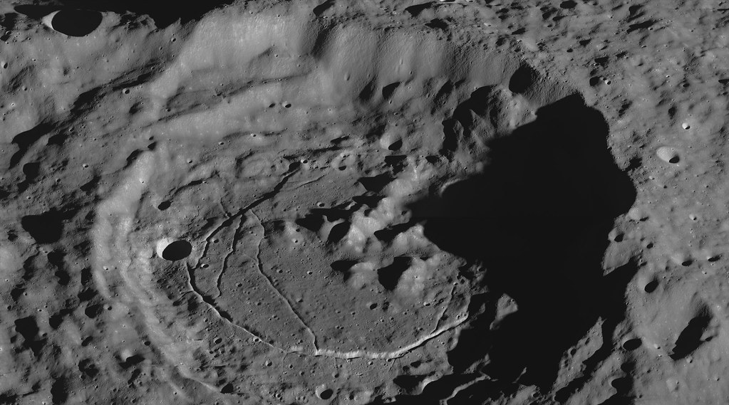
Oblique view of Karpinskiy floor fractures

Karpinskiy (oblique observation farside north)
LROC Narrow Angle Camera (NAC) oblique of the north floor of Karpinskiy crater, (91.4 km, 72.609°N and 166.801°E). Crater floor fractures abound,, concentric to the crater wall, a 6-km diameter impact crater on the floor and a disrupted jumble of central peaks. LROC NAC oblique mosaic M1115742016LR, orbit 16656, February 17, 2013; 82.48° incidence angle, resolution (maximum, and at full resolution) 2.42 meters per pixel, from 174.1 km over 77.81°N, 129.88°E) [NASA/GSFC/Arizona State University].
Raquel Nuno
LROC News System

Today’s Featured Image is an oblique image of the northeastern rim of Karpinskiy crater, a floor-fractured crater centered at 72.609°N, 166.801°E.

We can see wall terraces, superimposed impact craters of many sizes, and floor fractures. Fractures on the Moon are observed in different places. They can be seen as long linear rilles formed as the crust is pulled apart, and inside of craters, like in today’s Featured Image. How do these fractures inside the crater form? Lunar geologists propose two major formation mechanisms for crater floor fractures: intrusive magmatic activity and viscous relaxation. Intrusive magmatic activity is the process by which magma rises beneath the crater floor, causing excess pressure to build up, pushing the crater floor up; this extension causes it to crack. Viscous relaxation occurs as the lunar crust attempts to reach isostatic equilibrium, which it lost during excavation of large amounts of material during the impact. The the original curved floor flattens and is pushed up, causing it to fracture.

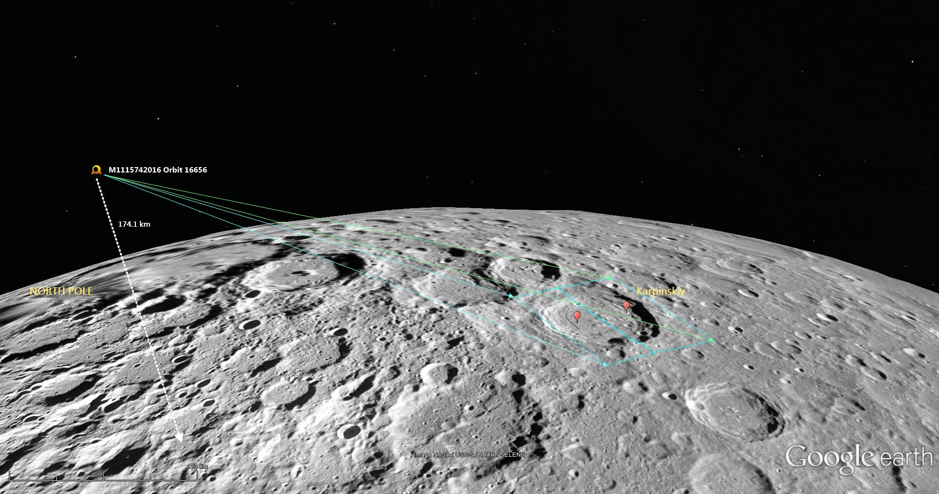
Google Moon -Orbital Dynamics of LROC NAC M1115742016LR
The dynamics of LROC NAC observation M1115742016, full size image HERE.
Karpinskiy (farside north) oblique
Thumbnail view of one version of the full-resolution LROC NAC mosaic, showing the interior and surrounding older crater within which Karpinskiy is nested. Various resolutions are available HERE.
Gain an astronaut's eye view of Karpinskiy crater with the oblique NAC image, HERE.

Related Posts:
Numerov's Graben
Pull Apart - Grabens
It's the Moon's Fault

Tuesday, August 20, 2013

Karpinskiy, superpositioned on the farside north

Karpinskiy WACGLD 100m
LROC Wide Angle Camera (WAC) mosaic overlaid with WAC and NAC-derived GLD100 color-coded digital elevation model. Karpinskiy crater is approximately 90 kilometers across and nested within the remains of an even larger and more ancient crater [NASA/GSFC/Arizona State University].
Raquel Nuno
LROC News System


Karpinskiy crater, at 72.609°N, 166.801°E and (officially 91.403 km) in diameter, rests within a larger and far older unnamed crater. How do we know which crater is older? Stratigraphic studies, or the study of superposition of rock layers (or in this case, craters), will help determine the relative ages of craters here. Geologists derive relative ages between geological features by observing how they overlap - young formations will always overlie older formations, and on airless bodies, such as the Moon and Mercury, this method becomes particularly useful. Without wind to erode its surface, only four factors affect the lunar surface: space weathering, impacts, tectonism, and volcanic resurfacing. With respect to today’s Featured Image, the Moon accumulates impact craters over time. From the cratering record we can investigate not only stratigraphic relationships (which crater formed first), but we can also derive a quantifiable measure, or crater density, to determine relative ages on the Moon.

Karpinskiy passes under Kaguya
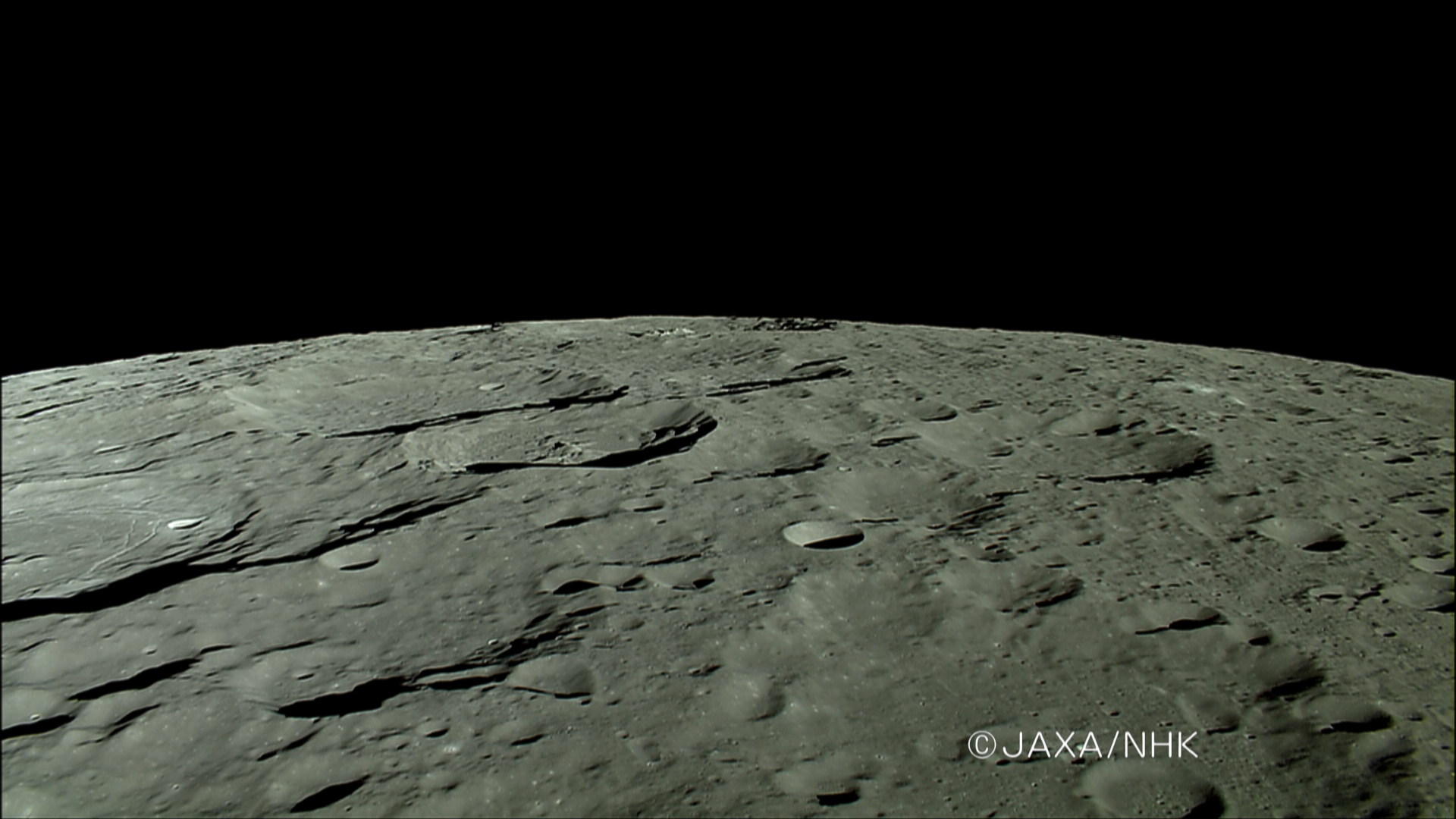
The HDTV camera onboard Japan's lunar orbiter Kaguya (SELENE-1) anticipates a rising Earth in 2007, looking north toward the Moon's north pole as it passes ancient craters of the Farside Highlands Terrain, including Karpinskiy, nested in a much older crater, passing out of view at left, followed by Milankovic and Plaskett. View the full-size image HERE [JAXA/NHK/SELENE].
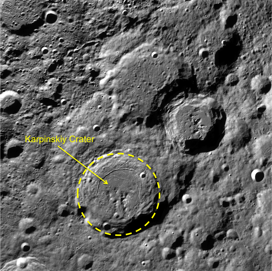
Today’s Featured Image is a great example for stratigraphic studies. The LROC WAC mosaic of Karpinskiy crater overlaid with the GLD100 color topography presents a clearer outline of the older crater (WAC mosaic below). The top portion of the image is black because the GLD100 product does not have coverage at that latitude (>79°N). Karpinskiy crater is located inside a much older, degraded crater that does not have a well-defined rim and is somewhat difficult to see in the WAC mosaic. Karpinskiy is younger because it superposes, or formed on top, of the unnamed older crater. There are younger craters superposed on the floor of Karpinskiy, that must have formed later and are therefore younger based on the relative age relationships. Thus, using stratigraphic relations we are able to derive a relative age for Karpinskiy, but what if we want to determine the absolute age? The number of craters that formed on Karpinskiy can be used to estimate its absolute age, however with such a small area the crater size frequency distribution absolute age estimate has a large uncertainty. To accurately determine the absolute age of Karpinskiy crater we have to go there and acquire samples of impact melt rock that we can radiometrically date!

Karpinskiy WAC superposition context
LROC WAC context image. Karpinskiy crater outlined in yellow, with the two neighboring craters to the north and east are Ricco, Milankovic and Milankovic E[NASA/GSFC/Arizona State University].
Explore the full image, HERE.

Related Posts:
Absolute Time
Copernicus Crater and The Lunar Timescale
Dating an Impact

Monday, August 19, 2013

Oblique look deep into the heart of Lowell crater

Lowell (LROC oblique)
Oblique LROC Narrow Angle Camera (NAC) mosaic of Lowell crater (62.65 km - 12.96°S, 256.58°E), super-positioned (or is it?) on the northeast quadrant of the Orientale basin. LROC NAC observations M1108918822R & L, spacecraft orbit 15696, November 30, 2012; angle of incidence 80.52° averaging 3 meters per pixel resolution (spacecraft and camera slew -62.35° from 91.55 km over 12.81°S, 262.88°) [NASA/GSFC/Arizona State University].

Named for the one and only Percival Lawrence Lowell (March 13, 1855 – November 12, 1916), popularizer of Mars lore in the late 19th century, and celebrated in part also by Clyde Tombaugh when he chose a name for "Pluto" in 1930, in the first two letters of that now "former planet's" Olympian moniker.
ILIADS-Lowell-2-1159x1611
Looking north over Lowell and the northwest Orientale basin. LROC Wide Angle Camera (WAC) global mosaic draped on LOLA laser altimetry using NASA ILIADS application [NASA/GSFC/MSFC/ASU].
Related Posts:
Oblique views of Moon's highest and lowest places (October 3, 2012)
Impact melt lobes (April 12, 2012)

"Abandoned McDonald's" key to Lunar Orbiter legacy

August 15 (Bloomberg) -- In an installment of "Secret Valley" Bloomberg Businessweek's Ashlee Vance visits NASA's Ames Research Center (ARC) where a "forgotten McDonald's," nicknamed "McMoon's," serves as headquarters for the Lunar Orbiter Image Restoration Project (LOIRP), a donation-driven labor of love designed  to digitize and rescue the fifty year old photographic record of the Lunar Orbiter project (1966-1967) [Bloomberg].
View the Video (2:50) HERE. (HT: Keith Cowing)

Good things delivered in small packages

Mighty Eagle Aces Exam (NASA, International Space Station, 09/05/12)
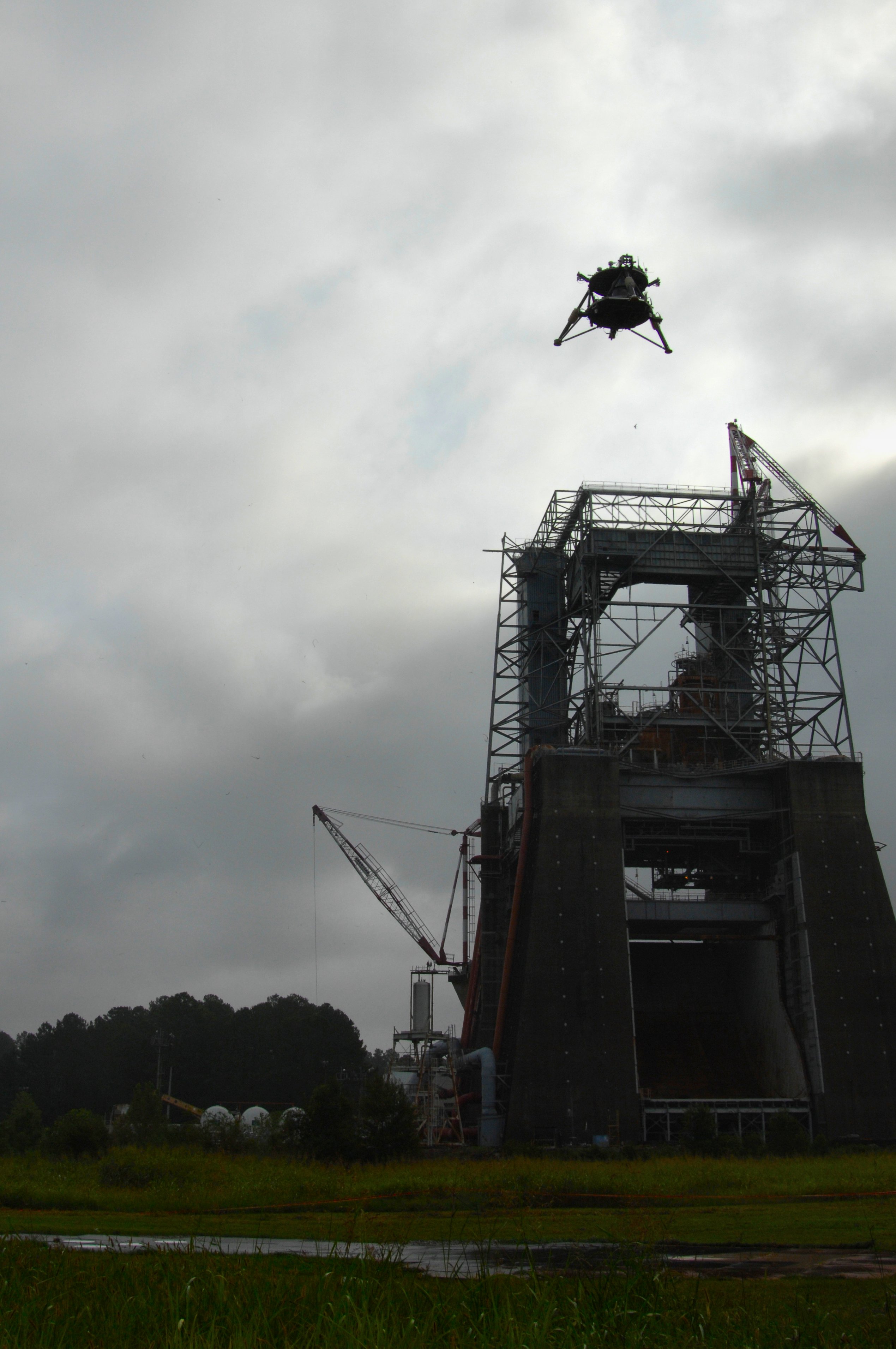
Overcast skies didn't deter the "Mighty Eagle," flying high over the historic F-1 test stand and completing a milestone round of flight test objectives, September 5, 2012. One of two NASA robotic prototype landers, the vehicle was flown to an altitude of 30.48 meters and descended gently to a controlled landing during a successful free flight Marshall Space Flight Center in Huntsville, Alabama. Nicknamed the "Mighty Eagle" after one of the characters in the popular "Angry Birds" game, the vehicle is a three-legged prototype,  that resembles an actual flight lander design. It is 1.219 meters high, 2.438 in diameter and, when fueled, weighs 317.5 kg. It's a, so-called, “green” vehicle, 90 percent fueled by pure hydrogen peroxide, guided by an onboard computer [NASA/MSFC].
Paul D. Spudis
The Once and Future Moon
Smithsonian Air & Space


Wanted: lander spacecraft to deliver payloads to the Moon.  Must be cheap and reliable.

NASA recently issued an “RFI” – a Request for Information – a method used by the agency to solicit concepts from various companies and gauge their ability to fulfill a future anticipated need.  In this case, the need is for a small robotic lander, one capable of delivering two classes of payloads to the lunar surface: small (from 30 to 100 kg) and medium (from 250 to 450 kg).

Probably focused near-term with the RESOLVE (Regolith and Environment Science and Oxygen and Lunar Volatiles Extraction) payload, the intent of this RFI is to survey existing capabilities for the commercial delivery of a variety of payloads to the Moon.  RESOLVE is a NASA experiment designed to test and demonstrate some techniques of in situ resource utilization (ISRU) on the Moon, specifically the generation of oxygen and the extraction of volatile elements (such as hydrogen) from lunar soil.  The RESOLVE package consists of several highly integrated experiments designed to collect soil on the Moon, heat this feedstock to various temperatures and measure the amount and type of volatile elements released, and practice some techniques of processing the soil into useful products (such as water or oxygen).

Though we’ve been talking about using off-planet resources for years, this is the first time the agency would fly an experiment designed to evaluate the processes and difficulties involved.  Some of us contend that until it is proven possible (by demonstrating it in space), space-based resource utilization (ISRU) will remain classified as “too risky” to incorporate into an architecture.  Engineers don’t doubt the chemistry or physics behind ISRU, but to evaluate risk and return, they want demonstrations using real hardware versus theoretical concepts and paper studies.

Although it will not answer all ISRU questions, RESOVLE can provide useful data and would be an important milestone.  Our ignorance is particularly vast in regard to the nature of the polar volatile deposits.  Some near-polar sites are under consideration for RESOLVE, but because the lander must be able to communicate with Earth, sites near the poles must be in radio view of Earth.  This eliminates the most promising polar volatile sites (permanently dark, out of radio sight) from consideration, at least for the first mission.  However, we know that water ice occurs in some areas in view of Earth, so careful targeting will permit us to get ground truth for a critical area near the one of poles.

There are a wide variety of possible payloads (scientific and resource utilization) for lunar missions using small landers.  A key priority for the lunar science community has been the deployment of a global network of geophysical instruments.  Such a package would include a seismometer (to monitor and measure moonquakes), a heat flow probe (to take the Moon’s temperature) and other instruments, such as a magnetometer and a laser reflector.  The five-station surface network laid out during the Apollo missions was operational for more than 7 years and gave us a first-order understanding of the nature of the deep lunar interior.  A new global network – widely spaced and operating longer with more stations – would vastly improve on that knowledge.

The success of a network mission necessitates a long-lived power source to operate instruments during the very cold, 14-day lunar night (the Apollo network used nuclear power supplies), along with an inexpensive way to deploy the network stations.  New technologies have developed small, reliable radioisotope generators that operate for many years.  A small lander could deliver geophysical stations across the entire globe; each station is low mass, so the smaller (and presumably cheaper) the lander, the more likely that this mission will be realized.  A global seismic network would decipher the crust and mantle structure of the Moon and could monitor its surface for large impacts.  A precise measurement of lunar heat flow (measuring the abundance of radioactive elements in the Moon) will give us more information about the bulk composition of the Moon and advance our understanding of lunar origin.  Laser ranging will also be useful in addressing some critical geophysical and astrophysical problems.


Project Morpheus vehicle "Morpheus Bravo," executes a successful tether test August 7, 2013 at Johnson Space Center. The combined Morpheus/JPL team met all their objectives including engine ignition, ascent, a 3 meter lateral translation over simulated Mars regolith simulant from JPL to help with plume study, 40 seconds of hover at apex and a slant descent to "landing" using free flight guidance. The entire flight duration was around 80 seconds. All though the Mars surface simulant was not typical for Morpheus test fires, it "sure made for a spectacular show"

Single-point landers, making simple measurements, can investigate the surface composition and geology at select landing sites.  If the landing sites and investigations are carefully chosen, they could significantly advance science by answering key questions.  For example, a critical issue in the cratering history of the Moon is knowledge of the absolute age of some of the youngest craters on the Moon.  The formation of the crater Copernicus marks a key time horizon in lunar history (the Copernican Period).  We know its relative age very well but are uncertain about its absolute age.  A small lander can be sent directly to the crater floor, where the impact melt is exposed and accessible, to analyze crater melt rocks for chemical composition and to learn the nature of the impact target (as well as determining the age of the rock by measuring the radiogenic potassium and argon in the rock). Although the potassium-argon technique is not the most precise method of radiometric dating, it can distinguish among the different proposed absolute ages, which vary over a billion years.  By determining this age more precisely, we will better understand the impact flux in the Earth-Moon system, knowledge that will help us better interpret the surface ages of units on other terrestrial planets.

Small landers could deliver a variety of long-lived assets for future surface operations and resource utilization experiments.  Techniques for making oxygen from lunar soil have been proposed but no comparative demonstration has been done on the Moon.  A small laboratory could be send to the Moon to conduct simultaneous experiments on oxygen manufacture.  The advantage of this experiment would be the use of identical feedstock under identical thermal and time constraints to compare their relative efficacy and identify any problems.  This experiment would fit on a small lander (~ 50 kg capacity) and by using solar power, within the span of a single lunar day (2 weeks) could quickly complete its evaluation.

The larger version of the RFI lander opens up other possibilities.  With a payload capacity on the order of 500 kg, this lander could deliver an advanced, automated surface rover (powered by an RTG – nuclear battery) able to undertake extensive and protracted exploration of the polar cold traps.  Equipped with instruments utilizing well established technology, this rover would characterize the physical, chemical and isotopic make up of the polar volatiles – a task critical for mapping the extent and purity of deposits of water ice on the Moon, and evaluating their mining and extraction potential.

The Canadian Space Agency test platform Artemis, Jr. fitted with NASA's RESOLVE instrument package, Day 3 of field testing on Mauna Kea, Hawai'i, July 2012 [CSA].
At this scale, it’s possible to deliver an ascent vehicle to the Moon to retrieve and return samples to Earth.  Scientists have a long list of desired targets for sample return and the potential for low cost, commercial landers to deliver payloads simply and inexpensively to the Moon could revolutionize our understanding of the Moon’s (and Earth’s) history and processes.  From remote sensing data, we know that many fascinating areas on the Moon display rocks either unrepresented or unrecognized in the existing collections from the American Apollo, Soviet Luna, and lunar meteorite samples.  Samples from the oldest impact feature on the Moon – the floor of the South Pole-Aitken basin – are especially desired.  Although a simple “grab” sample won’t answer all of our questions, rocks from this site could address major questions about the bombardment history of the Moon and the early Earth.

Small lander spacecraft will open up new horizons for science and exploration.  Critical to their success is making them simple, robust and inexpensive.  That’s been a tall order for NASA.  Whether the commercial sector can provide this capability more effectively remains to be seen.

Related Posts:
CHONDROBOT-2: Simple, Efficient Semi-Autonomous Lunar Excavator (January 4, 2013)
Technical Readiness (November 17, 2012)
Marshall's new-generation lunar lander flies again (September 11, 2012)
Update: ISRU mission simulations on Hawai'i (July 30, 2012)
'A RESOLVE to mine the Moon' (July 15, 2012)
KSC shows off RESOLVE, ISRU and lunar analog study platform (June 13, 2012)
Mighty Eagle lander's 100 foot flight at Redstone (November 4, 2011)
New Robotic Lander Prototype skates tests (January 29, 2011)
NASA update: ILN Anchor Nodes and Robotic Lunar Lander Project (August 17, 2010)
Field testing of In-Situ Resource Utilization (July 1, 2010)
The Lunar Quest Program and the International Lunar Network (September 6, 2009)
Spotlight on Carnegie-Mellon's SCARAB (April 10, 2009)

Originally published August 17, 2013 at his Smithsonian Air & Space blog The Once and Future Moon, Dr. Spudis is a senior staff scientist at the Lunar and Planetary Institute. The opinions expressed are those of the author but are better informed than average. 

Saturday, August 17, 2013

ISRO Chandrayaan-2 will go without Roscosmos

India's follow-up to its highly successful first lunar orbiter, Chandrayaan-2, together with a small remotely-operated rover landed on the Moon by a Russian spacecraft, had previously been delayed to 2013 and 2016 [ISRO/IKI].
P. Sunderarajan
The Hindu

"Chandrayaan 2 was originally envisaged to be a joint mission between ISRO (Indian Space Research Organisation) and the Russian Federal Space Agency, Roscosmos....Following the failure of the Russian-led interplanetary mission, Phobos-Grunt, a sample return mission to Phobos, one of the moons of Mars, the Russian agency reviewed their inter-planetary missions and decided to increase the mass of the moon lander...The Russian agency consequently suggested to ISRO two opportunities for launching of its Chandrayaan 2 rover - either 2015 or 2017 aboard Soyuz, the Russian spacecraft with a rider that the 2015 opportunity could involve mass limitation for the rover and entitle a higher risk....In the wake of these inputs, the ISRO conducted a high level review of the Chandrayaan 2 programme under the chairmanship of Prof. U.R.Rao. The study recommended that India could itself realise a lander module in a few years and that it could go in for the mission on its own."

Read the stories HERE, HT to "Spacetoday.net"

Fresh crater in the farside Saenger crater group

Fresh, unnamed crater in the farside Saenger crater group
A very fresh 3.2 km crater, with a bright, wide-ranging ejecta field, unusual melt erosion and ponding on its floor, blasted into a ridge in the Saenger crater group;  where the farside highlands begin, beyond the Moon's eastern limb at 4.579°N, 101.129°E.

Because it's nested on the northeastern side of a broad ridge, trending from southwest to northeast this very youthful crater's southeastern wall, rising 1180 meters above the level floor far below, is twice the height or more than its northwestern opposite.. Landslides of very fine materials run down the higher walls while the northwest is dominated by melt-carved ravines and boulders either draped with, or entirely composed of, dark melt and melt-fused composites.

There is also a hint of darker materials excavated in thin streams in the crater's ejecta immediately encircling its rim. The crater, which eventually deserves a name, is shown above in a 5.5 km-wide field of view from LROC Narrow Angle Camera (NAC) mosaic M167539260LR, spacecraft orbit 9824, August 9, 2011; 46° angle of incidence, resolution 61 centimeters per pixel from 59.58 km [NASA/GSFC/Arizona State University].

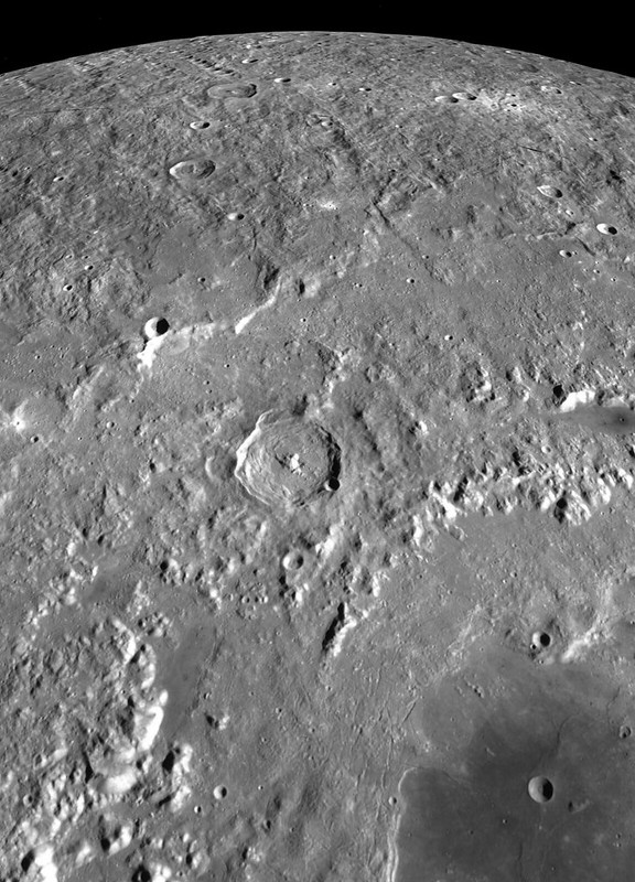
Heading east, following the equator, the high elevations distinctive to the Moon's farside, come into their own beyond the vast swirl fields of Mare Marginis. The 3.2 km crater immediately east of center in this field of view is nested in a wide ridge with an origin deeper in the distant past history of lunar morphology than Saenger crater, partly visible on the right. LROC Quick Map GLD100 DEM [NASA/GSFC/Arizona State University].
The global medium-resolution mosaic swept up by the PRC's Chang'e-2 (2011), under full illumination of a high Sun, offers good appreciation for the scope of the unnamed crater's ejecta rays system. This area is missing from Clementine (1994) albedo maps [CLEP/CNSA].
Some Related Posts:
Convergence (August 8, 2013)
Melted Moon (July 31, 2013)
The view inside a tilted crater (July 23, 2013)
Complicated Crater (June 19, 2013)
"Ka Pow!" on Joliot's central peaks (June 18, 2013)