Showing posts with label Lunar Geology. Show all posts

Saturday, February 8, 2014

Special Session, LPSC 2014 (March 17)

 45th Lunar and Planetary Science Conference
New Perspectives of the Moon -
Enabling Future Lunar Missions
The Woodlands, Texas
Monday Morning, March 17, 2014

Prasun Mahanti and Charles Shearer, Chairs

Recent and ongoing missions coupled with new data analyses have dramatically changed our view of the Moon over the last decade. Findings from these missions provide both a fundamental scientific framework to base future missions and essential observations to reduce risk to these missions. Presenters will provide new scientific synthesis of data produced from recent and current lunar missions and data analyses and examine innovative scientific mission strategies enabled by these new insights to address important lunar science and exploration questions.

At Noon on Monday, astronaut-geologist Harrison H. Schmitt will update this special session on "a number of new insights into the geology of Taurus Littrow and surrounding regions."
8:30 a.m. Zuber, Smith, Goossens, Asmar and Konopliv, et al. - A High-Resolution View of the Orientale Basin and Surroundings from the Gravity Recovery and Interior Laboratory (GRAIL), #2061

During the final weeks (the “endgame”) of the Gravity Recovery and Interior Laboratory (GRAIL) mission the orbital altitude of the dual spacecraft was lowered to an average of 11 km above the surface of the Moon. The endgame mapping strategy was designed to provide the highest-resolution coverage over the Orientale basin in order to provide a gravity map of a multi-ring impact basin at unprecedented resolution. (High-resolution data over other areas of the planet were acquired as well.)  We summarize methodology and present results of local analysis to produce a gravitational model with 3-5-km spatial resolution, appropriate for investigating the structure and evolution of Orientale and its surroundings.

8:45 a.m. Warren and Dauphas - Revised Estimation of the Bulk Composition of the Moon in Light of GRAIL Results, and Why Heat Flow Should be a Top Priority for Future Lunar Missions, #2298

The elemental composition of the Moon shows aspects of similarity but also some important differences relative to Earth. The differences are key constraints for modeling the origin of the Moon and planetary origins in general. Most obviously, and regardless of the important FeO issue that is a major focus of this work, the Moon’s total iron content is lower by a factor of 3-4 compared to Earth’s total iron of ~34 wt%.

9:00 a.m. Jolliff and Petro - Recent Mission Observations Provide Scientific Context and Enabling Support for Future Exploration of the Moon’s South Pole-Aitken Basin, #2357

We take an integrated look at results from recent missions, current knowledge gaps, and implications for future in situ or sample-return exploration.

LPSC 2014, #1398, Figure 1. Central South Pole-Aitken basin, LROC WAC base mosaic overlain by GLD100 WAC-derived DTM (scale in meters) showing current NAC geometric stereo image coverage.
The Moon’s South Pole-Aitken (SPA) Basin is a scientifically rich destination for future exploration by landed and sample-return missions.  The current Planetary Science Decadal Survey recognized this scientific potential in terms of the SPA basin’s importance for recording the chronology of major events in the early Solar System as well as for understanding lunar history, structure, and giant impact processes. Current and recent orbital mission results including LRO, GRAIL, Chandrayaan-1, and Kaguya are paving the way for an improved understanding of SPA basin geology and history, and indeed, posing new questions for future exploration.

9:15 a.m. Hurwitz and Kring - Destinations for Sampling Impact Melt Produced by the South Pole — Aitken Basin Impact Event, #1398

LPSC 2014 #1398, Figure 1: FeO (red-yellow tones) and Th (green-blue tones) anomalies from LP data in SPA, shown with images from the LRO Wide Angle Camera (WAC). Features of interest are labeled. SPA melt may also be found in material ejected from the basin, but the anomalies identified above indicate the highest concentration of this melted material.
The intensity of impact activity during the earliest history of the Solar System is poorly constrained due to the lack of samples collected from ancient planetary terrains. The South Pole – Aitken (SPA) basin is the oldest basin identified on the Moon based on stratigraphic superposition and, thus, represents a key target for characterizing this earliest impact record. To determine the absolute age of SPA, rocks that formed as a result of the impact, such as impact melt, must be identified, collected, and analyzed. In this paper, we use high-resolution images obtained by the Lunar Reconnaissance Orbiter Narrow Angle Camera (LROC NAC) to explore locations that potentially contain SPA impact melt. These observations are integrated with spectral analyses of surface compositions and models of melt sheet differentiation to identify destinations where SPA impact melt samples can be collected.

9:30 a.m. Lawrence, Stopar, Speyerer, Robinson and Jolliff - Characterizing Locations for Future Lunar Exploration Using Recent Mission Results, #2785

LPSC 2014, #2785 Figure 1. Example path planning algorithm output for Ina on a LROC Narrow Angle Camera image.
We present results from a project to characterize accessibility and science potential of high-priority locations for future lunar precursor missions.

9:45 a.m. Mahanti, Robinson and Stelling - How Deep and Steep are Small Lunar Craters? — New Insights from LROC NAC DEMs, #1584

Recent lunar missions (e.g. Lunar Reconnaissance Orbiter (LRO), Kaguya), carrying high resolution cameras (e.g. Lunar Reconnaissance Orbiter Camera (LROC) Narrow Angle Camera (NAC), Selene Terrain Camera) have acquired images that will lead to a deeper understanding of impact crater formation and degradation. Historical studies of lunar crater morphology exists for craters in the 10 km diameter range, but is somewhat lacking for craters in the 1 km D range, and rare for craters D below 200 m.

10:00 a.m. Robinson, Boyd, Denevi, Lawrence and Moser, et al. - New Crater on the Moon and a Field of Secondaries, #2164

LPSC 2014 #2164 Figure 1. LROC Narrow Angle Camera (NAC) before and after images of the same small patch of Mare Imbrium reveal the Marshall 17 March Impact Event, the first time an impact on the Moon observed on Earth in real time has been definitively identified from lunar orbit. The newly-formed crater is 18 meters in diameter. From "New Imbrium crater from impact observed on Earth" (December 17, 2013) [NASA/GSFC/Arizona State University].
Amateur and professional observatories monitor the Moon for flashes, interpreted to represent impact events. The NASA Lunar Impact Monitoring Program includes a dedicated telescope facility at Marshall Space Flight Center. The Marshall group recorded over 300 flashes (meteoroid impacts); their brightest recorded flash occurred on 17 March 2013 (20.599±0.172°N, 336.078±0.304°E). Subsequently, a series of Lunar Reconnaissance Orbiter Camera (LROC) Narrow Angle Camera (NAC) images were acquired over the period of June through November 2013 to investigate the nature of this flash.

LPSC 2014 #2164 Figure 2. Temporal ratio (before M183689789L / after M1129645568L) orange outline delimits proximal high reflectance ejecta, red line is the boundary of low reflectance ejecta, blue outline shows boundary of high reflectance outer continuous ejecta, scale bar is 1000 meters.
10:15 a.m. Lucey, Neumann, Paige, Riner and Mazarico, et al. - Evidence for Water Ice and Temperature Dependent Space Weathering at the Lunar Poles from LOLA and Diviner, #2325

LOLA measurements of zero phase reflectance of the Moon have revealed that polar regions in permanent shadow are significantly brighter at 1064 nm than equivalent surfaces that experience some illumination during the year Zuber et al. Several hypotheses for this brightening have been outlined, including water frost and a polar effect on space weathering.  Inclusion of Diviner temperature measurements to LOLA reflectance observations adds a physical chemical dimension to aid interpretation because of the exponential temperature dependence of surface frost lifetime against sublimation. In this abstract we present the results of LOLA measurements of surface reflectance in the polar regions, and assess the validity of the various hypotheses to explain the observations with special attention to temperature.

LPSC 2014 #2325, Figure 2. The distribution of normal albedos for areas in permanent shadow (PSR) and areas sometimes illuminated (Non-PSR) in the north pole (70-90°N). The two populations are significantly offset, though considerable overlap persists.
10:30 a.m. Retherford, Greathouse, Gladstone, Hendrix and Mandt, et al. - New Perspectives on the Lunar Far-UV Albedo: Implications of LRO Lyman Alpha Mapping Project (LAMP) Results for Future Exploration, #2372

LAMP FUV albedo maps are used to investigate the intriguing albedo differences that occur within PSRs. LAMP measurements indicate ~1-2% surface water frost abundances in a few PSRs based on spectral color comparisons, and we find that many PSRs may have porosities of ~0.7 based on relatively low albedos at Lyman-α [1]. The FUV albedo maps reveal lower albedo regions within craters. The lower albedo regions are roughly correlated with the coldest PSR regions, and Hayne et al., this meeting, will pre-sent correlative analyses with Diviner maps. Mandt et al., this meeting, will present updated analyses of the PSR water frost abundances including a search for changes on monthly timescales.

New dayside FUV albedo maps will also be pre-sented. Comparisons between the nightside and day-side photometry techniques help validate the use of Lyman-α and starlight as illumination sources. Analy-sis of dayside spectra for selected regions complement the dayside maps, and are used to investigate space weathering and hydrated surface signatures [5]. Hen-drix et al., this meeting, report that the Compton-Belkovich region presents a relatively red spectral slope in the LAMP dataset, and discuss the potential for surface hydration in this region. A lab study of the FUV reflectance properties of Apollo samples, lunar simulants, and water ice is underway to further charac-terize the UV reflectance techniques. The far-UV spec-tral inversion property of the lunar albedo discovered by the Apollo 17 UVS is confirmed with the LAMP dataset, and Seifert et al., this meeting, investigate fur-ther the contrast of UV-bright mare versus UV-dark highlands region features as a function of wavelength.

LPSC 2014 #1943 Figure 1. Overlay of Diviner annual maximum temperature (colors: 40-350 K) and Ly-α albedo from LAMP (grayscale) for the south polar region of the Moon. The outer edge of the Diviner map lies at 82.5°S.
10:45 a.m. Hayne, Retherford, Sefton-Nash and Paige - Temperature and Ultraviolet Albedo Correlations in the Lunar Polar Regions: Implications for Water Frost, #1943

LPSC 2014 #1942 Figure 3. Surface material with high UV water band depth from LAMP and Diviner Tmax < 130° K is indicated by shades of red in this south polar map. The background grayscale image is Diviner Tmax, a subset of Fig. 1.
11:00 a.m. Zhao, Huang, Xiao, Qiao and Xiao, et al. - Geology of CE-3 Landing Site and Path Planning for Yutu Rover, #1864

Nearly 40 years after the completion of Apollo program and Luna missions, the third Chi-nese lunar mission, Chang’e 3 (CE-3), was launched on December 2 2013, and it safely landed on the surface of the Moon on December 14 2013. The rover “Yutu” separated from the lander successfully about 8 hours later. The landing site of CE-3 is 340.49 °E, 44.12 °N, located in the northern part of Mare Imbrium and about 140 km east to Sinus Iridum. The landing area has a variety of geologic features, such as impact craters, wrinkle ridges and basaltic lava flows with different ages, making it an arresting place to study.

11:15 a.m. Garry W. B. - The Mare Imbrium Flow Field: Regional Geologic Context of the Chang’e 3 Landing Site, #2169

LPSC 2014 #2169 Figure 3. Topographic profiles of two different Phase III lava flows. Low-sun angle images show channels that are a few meters deep in the majority of the Phase III flows indicating preferred paths in many of these lobes.
The Mare Imbrium lava flows are unique to the lunar surface in that they have well-defined flow margins, levees, and channels that are traceable from the source region to the flow front. These flows were initially mapped with Apollo data [4,5], but the data sets did not provide complete coverage of the flow field at a consistent resolution. The overall goal of this study is to reevaluate the flow field with current data sets, create an updated morphologic map of the Mare Imbrium lava flows, and provide a qualitative and quantitative description of the emplacement of the flow field.

11:30 a.m. Hiesinger, Ivanov, Pasckert, Bauch and van der Bogert - Geology of the Lunar Glob Landing Sites in Boguslawsky Crater, #2370

LPSC 2014 #2370 Figure 2. New geologic map of Boguslawsky crater (72.9°S, 43.257°E). Landing ellipses shown in white.
On Nov. 17, 2011, the Space Council of the Russian Academy of Sciences, formally announced that the Luna-Glob and Luna-Resurs missions will be split into separate landing and orbiting missions. Although the main objective of the Luna-Glob lander is to test landing techniques, it will also carry a small scientific payload. The floor of crater Boguslawsky (~95 km in diameter, centered at 72.9°S, 43.26°E) was selected as primary landing site for the Luna-Glob mission. Two landing ellipses, 30x15 km each, were chosen on the  floor of the crater: Ellipse West is at 72.9°S, 41.3°E, Ellipse East is at 73.3S, 43.9E.

11:45 a.m. BREAK

12:00 p.m. Schmitt H. H. - Apollo 17: New Insights from the Synthesis and Integration of Field Notes, Photo-Documentation, and Analytical Data, #2732

A number of new insights into the geology of the valley of Taurus-Littrow and surrounding regions of the Moon have resulted from recent synthesis and integration of transmitted field notes, field recollections, and photodocumentation with over forty years of data from sample analysis and geophysical measurements.

Jack Schmitt's trench and the orange regolith he uncovered at Shorty crater. The minutes spent at this location left a deep mark on planetary science, visible from the Lunar Reconnaissance Orbiter and discussed by LROC principal investigator Mark Robinson in "Just another crater?" December 13, 2011; Apollo 17 Lunar Surface Journal. AS17-137-20900 [NASA].
For further information about the 45th Lunar and Planetary Science Conference visit:
http://www.hou.usra.edu/meetings/lpsc2014/

Friday, January 31, 2014

Geologic characteristics: Chang’E-3 exploration region

From extensive data distilled from remote sensing collected by the DIVINER Lunar Radiometer on-board the Lunar Reconnaissance Orbiter (LRO) since July 2009 has allowed David Page and the DIVINER team to produce extensive maps of the thermal behavior "and a range of derived quantities at the Chang'e-3 landing site, described in a separate report released January 5. Distinct areas can be seen in LROC WAC Surveys, with an overlay mapping rock abundance using thermal dissipation temperatures collected at the coldest periods, before local sunrise. DIVINER detected no minimum temperatures in the area below 94°K [NASA/JPL/UCLA/GSFC/ASU].
Zhao, Huang & Qiao, et.al.
Planetary Science Institute
China University of Geosciences, Wuhan

Science China (March 2014)

ABSTRACT: We present topographic, geomorphologic and compositional characteristics of a 1°×1° (~ 660 square kilometer) region centered near the landing site of Chang’E-3 using the highest spatial resolution data available. We analyze the topography and slope using Digital Terrain Model (DTM) generated from Terrain Camera (TC) images. The exploration region is overall relatively flat and the elevation difference is less than 300 meters, and eighty percent of the area slopes are less than 5°. 

Impact craters in the exploration region are classified into four types based on their degradation states. We investigate the wrinkle ridges visible in the exploration region in detail, using TC and Lunar Reconnaissance Orbiter (LRO) Narrow Angle Camera (NAC) images. We calculate iron oxide and titanium dioxide abundances using Multispectral Imager (MI) data and confirm two basaltic units: the northern part, belonging to Imbrium era low-titanium to very-low titanium mare basalts, and the southern part is Eratosthenian era low titanium to high titanium mare basalts. 

Finally, we produce a geological map and propose the geologic evolution of the exploration region. 

M177x3C_604nm-anot-580x800
The north central Mare Imbrium exploration region and landing site of Chang'e-3.  The geology report dates the northern mare to the Imbrium Age and the southern mare, in the lander's immediate vicinity to the Eratosthenian age, two billion years apart. LROC WAC mosaic swept up in three sequential orbits, December 5, 2011; sunrise angle of incidence 76° at 61.5 meters per pixel resolution, from 44.7 km [NASA/GSFC/Arizona State University].
INTRODUCTION: Nearly 40 years after the completion of the Apollo and Luna missions, the third Chinese lunar mission, Chang’E-3 (CE-3), was launched on December 2, 2013 and safely landed on the surface of the Moon on December 14, 2013.

The rover “Yutu” separated from the lander successfully about 8 hours later. The landing site of CE-3 is 44.12°N, 340.49°E, which is located in the northern part of Mare Imbrium. As the first Chinese lunar soft-lander and rover, the landing site was selected primarily considering engineering constraints, including topography, communication and solar illumination.

In addition, local geologic diversity was also taken into consideration, including impact craters, wrinkle ridges, and basaltic materials of different ages. The CE-3 landing site and its nearby terrains have never been visited by any other missions. Therefore, the exploration will shed light on the geologic characteristics, geochemical diversity and evolution of Mare Imbrium.

Geological maps in Apollo era and recent studies reveal regional geologic information for Sinus Iridum and the adjacent terrains. However, the spatial resolution of previous maps is not sufficient for detailed geologic study or for the rover traverse planning considering both scientific and engineering requirements. Luckily, as unprecedented high spatial resolution remote sensing data being acquired by recent lunar missions (e.g., Chang’E 1 & 2, SELENE-1, Chandrayaan-1 and Lunar Reconnaissance Orbiter: LRO), large scale geological mapping and detailed study were possible for prior study of the Chang'e-3 landing site and its exploration region. 

Read or Download the Full Adobe PDF file HERE.

Monday, August 19, 2013

Good things delivered in small packages

Mighty Eagle Aces Exam (NASA, International Space Station, 09/05/12)
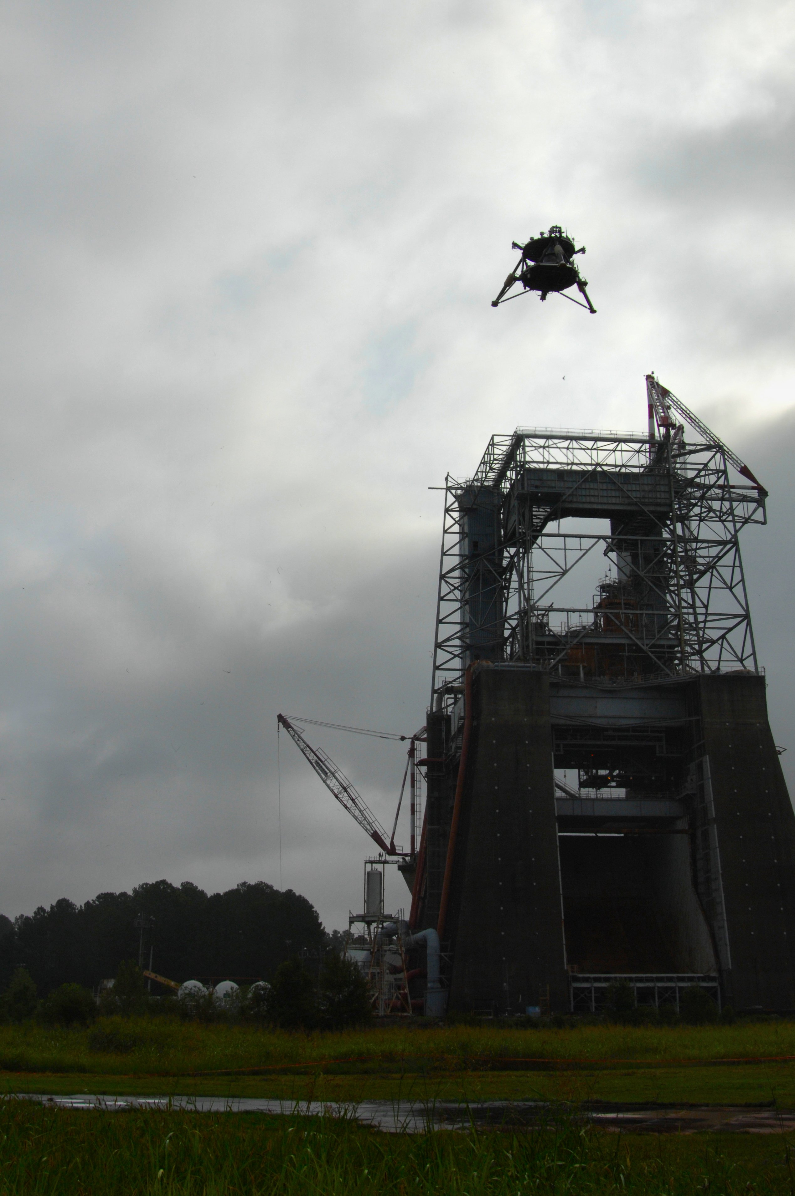
Overcast skies didn't deter the "Mighty Eagle," flying high over the historic F-1 test stand and completing a milestone round of flight test objectives, September 5, 2012. One of two NASA robotic prototype landers, the vehicle was flown to an altitude of 30.48 meters and descended gently to a controlled landing during a successful free flight Marshall Space Flight Center in Huntsville, Alabama. Nicknamed the "Mighty Eagle" after one of the characters in the popular "Angry Birds" game, the vehicle is a three-legged prototype,  that resembles an actual flight lander design. It is 1.219 meters high, 2.438 in diameter and, when fueled, weighs 317.5 kg. It's a, so-called, “green” vehicle, 90 percent fueled by pure hydrogen peroxide, guided by an onboard computer [NASA/MSFC].
Paul D. Spudis
The Once and Future Moon
Smithsonian Air & Space


Wanted: lander spacecraft to deliver payloads to the Moon.  Must be cheap and reliable.

NASA recently issued an “RFI” – a Request for Information – a method used by the agency to solicit concepts from various companies and gauge their ability to fulfill a future anticipated need.  In this case, the need is for a small robotic lander, one capable of delivering two classes of payloads to the lunar surface: small (from 30 to 100 kg) and medium (from 250 to 450 kg).

Probably focused near-term with the RESOLVE (Regolith and Environment Science and Oxygen and Lunar Volatiles Extraction) payload, the intent of this RFI is to survey existing capabilities for the commercial delivery of a variety of payloads to the Moon.  RESOLVE is a NASA experiment designed to test and demonstrate some techniques of in situ resource utilization (ISRU) on the Moon, specifically the generation of oxygen and the extraction of volatile elements (such as hydrogen) from lunar soil.  The RESOLVE package consists of several highly integrated experiments designed to collect soil on the Moon, heat this feedstock to various temperatures and measure the amount and type of volatile elements released, and practice some techniques of processing the soil into useful products (such as water or oxygen).

Though we’ve been talking about using off-planet resources for years, this is the first time the agency would fly an experiment designed to evaluate the processes and difficulties involved.  Some of us contend that until it is proven possible (by demonstrating it in space), space-based resource utilization (ISRU) will remain classified as “too risky” to incorporate into an architecture.  Engineers don’t doubt the chemistry or physics behind ISRU, but to evaluate risk and return, they want demonstrations using real hardware versus theoretical concepts and paper studies.

Although it will not answer all ISRU questions, RESOVLE can provide useful data and would be an important milestone.  Our ignorance is particularly vast in regard to the nature of the polar volatile deposits.  Some near-polar sites are under consideration for RESOLVE, but because the lander must be able to communicate with Earth, sites near the poles must be in radio view of Earth.  This eliminates the most promising polar volatile sites (permanently dark, out of radio sight) from consideration, at least for the first mission.  However, we know that water ice occurs in some areas in view of Earth, so careful targeting will permit us to get ground truth for a critical area near the one of poles.

There are a wide variety of possible payloads (scientific and resource utilization) for lunar missions using small landers.  A key priority for the lunar science community has been the deployment of a global network of geophysical instruments.  Such a package would include a seismometer (to monitor and measure moonquakes), a heat flow probe (to take the Moon’s temperature) and other instruments, such as a magnetometer and a laser reflector.  The five-station surface network laid out during the Apollo missions was operational for more than 7 years and gave us a first-order understanding of the nature of the deep lunar interior.  A new global network – widely spaced and operating longer with more stations – would vastly improve on that knowledge.

The success of a network mission necessitates a long-lived power source to operate instruments during the very cold, 14-day lunar night (the Apollo network used nuclear power supplies), along with an inexpensive way to deploy the network stations.  New technologies have developed small, reliable radioisotope generators that operate for many years.  A small lander could deliver geophysical stations across the entire globe; each station is low mass, so the smaller (and presumably cheaper) the lander, the more likely that this mission will be realized.  A global seismic network would decipher the crust and mantle structure of the Moon and could monitor its surface for large impacts.  A precise measurement of lunar heat flow (measuring the abundance of radioactive elements in the Moon) will give us more information about the bulk composition of the Moon and advance our understanding of lunar origin.  Laser ranging will also be useful in addressing some critical geophysical and astrophysical problems.


Project Morpheus vehicle "Morpheus Bravo," executes a successful tether test August 7, 2013 at Johnson Space Center. The combined Morpheus/JPL team met all their objectives including engine ignition, ascent, a 3 meter lateral translation over simulated Mars regolith simulant from JPL to help with plume study, 40 seconds of hover at apex and a slant descent to "landing" using free flight guidance. The entire flight duration was around 80 seconds. All though the Mars surface simulant was not typical for Morpheus test fires, it "sure made for a spectacular show"

Single-point landers, making simple measurements, can investigate the surface composition and geology at select landing sites.  If the landing sites and investigations are carefully chosen, they could significantly advance science by answering key questions.  For example, a critical issue in the cratering history of the Moon is knowledge of the absolute age of some of the youngest craters on the Moon.  The formation of the crater Copernicus marks a key time horizon in lunar history (the Copernican Period).  We know its relative age very well but are uncertain about its absolute age.  A small lander can be sent directly to the crater floor, where the impact melt is exposed and accessible, to analyze crater melt rocks for chemical composition and to learn the nature of the impact target (as well as determining the age of the rock by measuring the radiogenic potassium and argon in the rock). Although the potassium-argon technique is not the most precise method of radiometric dating, it can distinguish among the different proposed absolute ages, which vary over a billion years.  By determining this age more precisely, we will better understand the impact flux in the Earth-Moon system, knowledge that will help us better interpret the surface ages of units on other terrestrial planets.

Small landers could deliver a variety of long-lived assets for future surface operations and resource utilization experiments.  Techniques for making oxygen from lunar soil have been proposed but no comparative demonstration has been done on the Moon.  A small laboratory could be send to the Moon to conduct simultaneous experiments on oxygen manufacture.  The advantage of this experiment would be the use of identical feedstock under identical thermal and time constraints to compare their relative efficacy and identify any problems.  This experiment would fit on a small lander (~ 50 kg capacity) and by using solar power, within the span of a single lunar day (2 weeks) could quickly complete its evaluation.

The larger version of the RFI lander opens up other possibilities.  With a payload capacity on the order of 500 kg, this lander could deliver an advanced, automated surface rover (powered by an RTG – nuclear battery) able to undertake extensive and protracted exploration of the polar cold traps.  Equipped with instruments utilizing well established technology, this rover would characterize the physical, chemical and isotopic make up of the polar volatiles – a task critical for mapping the extent and purity of deposits of water ice on the Moon, and evaluating their mining and extraction potential.

The Canadian Space Agency test platform Artemis, Jr. fitted with NASA's RESOLVE instrument package, Day 3 of field testing on Mauna Kea, Hawai'i, July 2012 [CSA].
At this scale, it’s possible to deliver an ascent vehicle to the Moon to retrieve and return samples to Earth.  Scientists have a long list of desired targets for sample return and the potential for low cost, commercial landers to deliver payloads simply and inexpensively to the Moon could revolutionize our understanding of the Moon’s (and Earth’s) history and processes.  From remote sensing data, we know that many fascinating areas on the Moon display rocks either unrepresented or unrecognized in the existing collections from the American Apollo, Soviet Luna, and lunar meteorite samples.  Samples from the oldest impact feature on the Moon – the floor of the South Pole-Aitken basin – are especially desired.  Although a simple “grab” sample won’t answer all of our questions, rocks from this site could address major questions about the bombardment history of the Moon and the early Earth.

Small lander spacecraft will open up new horizons for science and exploration.  Critical to their success is making them simple, robust and inexpensive.  That’s been a tall order for NASA.  Whether the commercial sector can provide this capability more effectively remains to be seen.

Related Posts:
CHONDROBOT-2: Simple, Efficient Semi-Autonomous Lunar Excavator (January 4, 2013)
Technical Readiness (November 17, 2012)
Marshall's new-generation lunar lander flies again (September 11, 2012)
Update: ISRU mission simulations on Hawai'i (July 30, 2012)
'A RESOLVE to mine the Moon' (July 15, 2012)
KSC shows off RESOLVE, ISRU and lunar analog study platform (June 13, 2012)
Mighty Eagle lander's 100 foot flight at Redstone (November 4, 2011)
New Robotic Lander Prototype skates tests (January 29, 2011)
NASA update: ILN Anchor Nodes and Robotic Lunar Lander Project (August 17, 2010)
Field testing of In-Situ Resource Utilization (July 1, 2010)
The Lunar Quest Program and the International Lunar Network (September 6, 2009)
Spotlight on Carnegie-Mellon's SCARAB (April 10, 2009)

Originally published August 17, 2013 at his Smithsonian Air & Space blog The Once and Future Moon, Dr. Spudis is a senior staff scientist at the Lunar and Planetary Institute. The opinions expressed are those of the author but are better informed than average

Saturday, June 9, 2012

Back to the Moon: The Scientific Rationale for Resuming Lunar Surface Exploration

Capt. Gene Cernan, USN (Ret.), at the beginning of the third and final EVA of Apollo 17, December 13, 1972 [NASA/Harrison Schmitt].
I. A. Crawford, et al*.
Accepted for publication in a forthcoming Special Issue of
Planetary and Space Science on
"Scientific Preparations for Lunar Exploration"


The lunar geological record has much to tell us about the earliest history of the Solar System, the origin and evolution of the Earth-Moon system, the geological evolution of rocky planets, and the near-Earth cosmic environment throughout Solar System history. In addition, the lunar surface offers outstanding opportunities for research in astronomy, astrobiology, fundamental physics, life sciences and human physiology and medicine. This paper provides an interdisciplinary review of outstanding lunar science objectives in all of these different areas. It is concluded that addressing them satisfactorily will require an end to the 40-year hiatus of lunar surface exploration, and the placing of new scientific instruments on, and the return of additional samples from, the surface of the Moon. Some of these objectives can be achieved robotically (e.g. through targeted sample return, the deployment of geophysical networks, and the placing of antennas on the lunar surface to form radio telescopes). However, in the longer term, most of these scientific objectives would benefit significantly from renewed human operations on the lunar surface. For these reasons it is highly desirable that current plans for renewed robotic surface exploration of the Moon are developed in the context of a future human lunar exploration program, such as that proposed by the recently formulated Global Exploration Roadmap.

Read the full arXiv.org research, HERE. (PDF)

Related:

The Scientific Context for the Exploration of the Moon (2007)
Space Studies Board, National Research Council of the National Academies

*M. Anand, C. S. Cockelle, H. Falcke, D. A. Green, R. Jaumann & M. A. Wieczorek

Saturday, July 24, 2010

Special G. K. Gilbert Award Session for Carle Pieters at Geological Society of America

Each year the Planetary Geology Division of the Geological Society of America, responding to peer nominations, presents the G.K. Gilbert Award to a planetary scientist in recognition of outstanding contributions to the solution of fundamental problems in planetary geology through the use of geochemistry, mineralogy, petrology, geophysics, geologic mapping, and/or remote sensing. The Gilbert Award is the highest honor the Division can bestow.

This year's Gilbert Award will be presented to Dr. Carle M. Pieters for her pioneering work in remote sensing of planetary surfaces and crusts.

The award is named for G. K. Gilbert, who 100 years ago clearly recognized the importance of a planetary perspective in solving terrestrial geologic problems. The G. K. Gilbert Award is presented annually for outstanding contributions to the solution of fundamental problems in planetary geology in the broadest sense, which includes geochemistry, mineralogy, petrology, geophysics, geologic mapping, and remote sensing. Such contributions may consist either of a single outstanding publication or a series of publications that have had great influence in the field.

Presentation of the G. K. Gilbert Award is made during the annual business meeting of the Division held in association with the Annual Meeting of the Society.

Head's Up to Dr. Clive Neal

Thursday, July 22, 2010

Don Wilhelms receives Shoemaker Award

Don Edward Wilhelms received the Shoemaker Distinguished Lunar Scientist Award last night during a ceremony of the Lunar Science Forum at NASA's Ames Research Center, Moffett Field, Calif. The award is given annually to a scientist who has significantly contributed to the field of lunar science.

Wilhelms was hired by Gene Shoemaker and worked at the United States Geological Survey (USGS), Menlo Park, Calif., as an astrogeologist for 24 years. He retired from the USGS in 1986.

His research was very broad, covering nearly all categories of lunar science. According to scientists, no student of the lunar surface, its terrain, and the geologic context of samples can function without the framework developed by Wilhelms.

"Dr. Wilhelms has literally written the book on lunar geology. Both of his books, 'To a Rocky Moon' and 'The Geologic History of the Moon,' have been required reading for students of lunar science," said David Morrison, retiring director of the Lunar Science Forum.

David King of the Lunar and Planetary Institute in Houston notes, "Wilhelms' real-time guidance to the Apollo program was extraordinary. Furthermore, his geologic analyses and interpretative maps continued to shape our measure of the Moon for decades after the Apollo era."


The Rima Hyginus region from the USGS Mare Vaporum Quadrangle, by Don Wilhelms {1968) [LPOD/moonzoo].

The first Distinguished Lunar Scientist Award was given posthumously last year to Gene Shoemaker and presented to his wife, Carolyn, for Shoemaker's many contributions to the lunar geological sciences.

Tuesday, January 26, 2010

Lunar geophysicists convene at ASU

Dr. Harrison "Jack" Schmitt, former U.S. Senator and the twelfth and last man to set foot on the Moon for the first time in 1972, keynotes for geophysicists gathered at Arizona State University last week. He discussed data collected and archived from the Apollo Era and lessons for the future [Scott Stuk].

Lee Allison
Arizona Geology

Geophysicists gathered at ASU's School of Earth and Space Exploration last week for a 2-day workshop to "highlight how the geophysical community can contribute to NASA’s long-term plans to install a series of autonomous geophysical stations on the Moon."

Co-convenor Matt Fouch said, “The goal of the scientific exchange is to provide NASA and the broader scientific community with ideas and recommendations about how to most efficiently and effectively collect new geophysical data from the lunar surface, using everything from landers to robots to astronauts, and over a range of local, regional, and global scales."

Read the full article HERE.

Scientists discuss lunar visits, possible return

Rheyanne Weaver
Arizona State Press

ASU hosted one of the first specific workshops on ground-based geophysics of the moon on the Tempe campus Thursday and Friday.

The event focused on the discussion of the physical state and knowledge of the moon, as well as future plans to visit the moon.

“One of the primary goals for the workshop was to provide an interface between the planetary and the terrestrial geophysical communities,” said Matthew Fouch, an associate professor at the School of Earth and Space Exploration and one of the event’s coordinators.

Read the full article HERE.

Monday, January 25, 2010

To a Rocky Moon: A Geologist's History of Lunar Exploration

Don E. Wilhelms
To a Rocky Moon: A Geologist's History of Lunar Exploration
The University of Arizona Press | 1994 | ISBN: 0816514437 | 524 pages | PDF | 180 Mb

Don Wilhelms was a member of the Apollo Scientific Team and the US Geological Survey. In this book he describes his role, along with his geologist colleagues, during the Apollo explorations of the Moon. In addition, he presents a brief history of the theories associated with the origin of the moon and its craters, the people and problems involved in the section of the Apollo landing sites, a discussion of the geological results obtained from each of the Apollo landing sites, and finally a summary of the findings from the Apollo missions and the development of a theory to explain the formation of the moon.

(Ed. Note: The entirety of Dr. Wilhelms' landmark book in Adobe Reader format is presently available from multiple on-shore and off-shore commercial servers, HERE. Though there is no cost aside from the bandwidth and time needed to download a 180 megabyte "zipped" .rar archive file, this notice is not an endorsement for what may or may not be a proprietary or copywrite violation. It can, however, be considered as strong an endorsement of Dr. Wilhelms' important work and this book, in particular. The time is long overdue that this work from 1992 be made available to a younger audience and in a modern form.)

Saturday, August 29, 2009

Rock Star: Bill Muehlberger

Bill Muehlberger, professor emeritus with the University of Texas' geosciences school, teacher to American astronauts for 45 years.

Brad Buchholz
Austin American-Stateman

Respected UT geologist Bill Muehlberger showed astronauts the ins and outs of rocks - and even has a lunar momento with his name on it.

Bill Muehlberger has been talkin' rocks to astronauts for 45 years. He's taught geology to Gemini spacewalkers and Apollo moonwalkers, to the space shuttle crews, to the first astronaut classes of the 21st century. He's led geologic field trips to the volcanoes of Hawaii, to the impact craters of Arizona, to the deserts of West Texas — so that space travelers might better know the Earth, and by extension, better imagine the moon.

It is only fitting, therefore, that NASA chose to nickname a moon rock in the man's honor. The rock — "Big Muley" — is a whitish chunk of anorthosite collected by the astronauts of Apollo 16. At just short of 26 pounds, "Big Muley" (aka lunar sample 61016) is the largest and heaviest piece of the moon ever brought back to Earth.

Read the Scientist's Profile HERE.

Saturday, June 20, 2009

Space Geology: From the Moon to Mars


Dr. Harrison Schmitt, in one of the many now iconic photographs taken during his field expedition to Taurus-Littrow valley, samples the diverse lunar regolith. Eugene Cernan, Apollo 17, December 1972)

Harrison H. Schmitt, for Scientific American, July 2009 "Mountains higher than the walls of the Grand Canyon of the Colorado towered above the long, narrow valley of Taurus-Littrow. A brilliant sun, brighter than any sun experienced on Earth, illuminated the cratered valley floor and steep mountain slopes, starkly contrasted against a blacker-than-black sky. My crewmate Gene Cernan and I explored this nearly four-billion-year-old valley, as well as the slightly younger volcanic lava rocks and ash partially filling it, for three days in 1972—concluding the Apollo program. It was the first and, so far, only time a geologist has ever done hands-on study of another world. Now the U.S., the European Union, Russia and other international partners are contemplating sending astronauts to Mars to do fieldwork there, probably beginning within the first third of this century. What will be new and what will be familiar to the first geologist to step before a red Martian sunrise?"

Read the Feature HERE.

Saturday, June 13, 2009

Robotic Recon in Arizona

With Kaguya coming down and LRO & LCROSS going up, together with STS-127 visiting ISS, Lee Allison at Arizona Geology was almost alone in celebrating "The Desert Rats," sponsored by NASA's Lunar Science Institute at NASA Ames, a week ago.

From June 14-27, 2009, NASA will use a robot to scout portions of the Black Point Lava Flow in northern Arizona.

The K10 robot will be remotely operated from the NASA Lunar Science Institute located at the NASA Ames Research Center (Moffett Field, California). The data from “robotic recon” will be used to plan field work, which will be subsequently carried out by astronauts driving in the “Lunar Electric Rover.”
Image - NASA
Read the Background HERE.

Thursday, February 12, 2009

Cryptomare tripled by combination analysis

Portion of the lunar farside at 15N, 205W. Color is stretched lunar crustal thickness using topographic data. Thin crust in blues, thick crust in reds. Contour interval 4 km. Basins identified by Don Wilhelms in the Geologic History of the Moon (1987) and also found in ULCN topography as detailed by Frey in LPSC XXXIX Abstract 1344 (2008) shown as solid black circles. Dashed black circles are new basins identified in the ULCN topography. Circular Thin Areas (CTAs) that may be additional new large basins.

Herbert Frey of the NASA Planetary Geodynamics Lab at Goddard has tripled the number of previously unidentified "cryptomare," relatively early basins on the Moon obliterated by subsequent bombardment, melt flow and secondary cratering.

"The total number of lunar basins greater than 300 kilometers in diameter may exceed 150, more than 3 times that determined by photogeologic mapping alone," and without the Unified Lunar Control Network 2005 (ULCN 2005) topography.

Frey's findings have been published ahead of a scheduled presentation at the 40th Annual Lunar and Planetary Science Conference meeting in March (Abstract 1687).

Thursday, June 12, 2008

Brick and Glass from Lunar Regolith

The road ahead for the Lunar Pioneer is already a carefully ordered and logical one. It will be a while longer before boots return to the ground, if NASA has its way. Reading the commissioned studies and tight budgets, however, shows us what may be a necessary discipline.

And, in the long run, proving possible what was once science fiction is also necessary if the tough road toward permanent settlement is going to be tolerable.
Among those things long hoped for has been the grinding of lenses from the Moon itself. Now, in one week, NASA has shown both glass and sheltering bricks can be made from lunar regolith.

Of course, these popular developments coming, as they do, as an ambivalent Congress deliberates a larger than expected budget is not by chance. But, however good fortune has proven it, what many of us have long known could and should be done on the Moon is manifest, and we're glad.

It is a hint, a momentary glimpse of a marvelous future astronomy that will make the benighted Hubble as quaint as Hale.

Read more HERE.

Thursday, May 1, 2008

Senator Schmitt, Unfinished Business - lunar exploration

Former U.S. Senator Harrison "Jack" Schmitt (R-NM) was the second to the last person to walk on the moon, and the only pure scientist, and certainly the only geologist Apollo veteran. Last month, he came to the Space Center IMAX theater and gave a compelling talk reasoning on the necessity of resuming direct lunar exploration. Fortunately, the presentation was recorded and uploaded to YouTube recently.

Dr. Harrison 'Jack' Schmitt: Return to the Moon:
What it was like and what it will be like
Download the lecture slides in
Power Point or PDF
Introductions and pre-lecture Q&A, 43min
(download)


Dr. Jack Schmitt lecture and additional Q&A, 65min (download)

Wednesday, April 30, 2008

Dr. Rebecca Ghent of the "LRO 24" presents "a Striking History"

On March 11, Dr. Rebbecca Ghent of the University of Toronto was chosen by NASA as one of the "LRO 24," a group picked by NASA to help decide how best the Lunar Reconnaissance Orbiter will collect science on its mission later this year. The LRO-LCROSS mission is nearly assembled and was reportedly scheduled for vacuum chamber stress testing under supervision by the Goddard Spaceflight Center.

Among the stated goals of LRO are testing new technologies, identifying potential landing sites, sampling the back-scatter from Cosmic Rays and solar particles from the lunar surface and the moon's "striking" geological history, which is believed to be a literal recording of the same history of the Solar System since the Moon formed 4.725 billion years ago.

Overnight Chuck Wood of the Lunar Photograph of the Day (LPOD) wiki has opened a discussion of an "important article" in the May issue of Geology showing an incredible mosaic of lunar radar data.

The image put together by Dr. Ghent and colleagues has resulted in an wrap-around image of lunar morphology adding to debate over the long-theorized relationship between the Mare Orientale impact basin, the "eastern sea" marking the eastern limb of near side with it's familiar bull's eye, and lava-filled floors of older impact craters in the southern highlands and as far away as Shackleton nestled adjacent to the lunar south pole and within the ancient Aiken Basin, eighty percent of which is on the far side and invisible to Earth-bound observations.

Aside from helping establish the relationship between older craters and the freshness of their basalt-filled apparently newer floors, Ghent and her colleague's work will greatly serve the LRO's mission of discovering in situ resources.

Like all but a few of the large basalt-filled lunar "seas" of Earth's moon, which make up such a predominant feature characterizing the familiar near side, tidally locked into ever facing Earth, Mare Orientale is a "mascon," a localized concentration of mass perturbing the orbits of satellites in both equatorial and polar low lunar orbit and demonstrating the still mysterious anisotropy of the moon itself. The center of the large prominent basin is lower, dipping down below the mean levels of the surrounding surface. Two concentric rings encircling the inner basin are also basalt-filled, dipping lower than the mean surface's distance from the unresolved lunar "center."

As with all other mascons, gravity increases in effect on the space surrounding them in inverse proportion to their seeming size. Gravimetric maps of the lunar "seas" show what appears to be a mountainous mass peaked at Mare Orientale's basin with surrounding ridges rather than the circular valleys mapped by radar and Kaguya's laser altimeter.

Now among the "LRO 24," Dr. Ghent teaches geology at the University of Toronto.

She earned a bachelor’s degree in Physics in 1993 from Randolph-Macon Woman’s College. She earned her masters degree a year later at Georgia Tech and taught Physics at Georgia's Gordon College before returning to graduate school to study geology. In 2002, Ghent earned a Ph.D. in geology from Southern Methodist University and held a postdoctoral fellowship at the Smithsonian Institution in DC in 2006, before becoming part of the faculty at Toronto.

Monday, April 28, 2008

Cat shoots for the moon

Company teams with NASA to build habitats, roads on lunar surface

By PAUL GORDON of the Peoria Journal Star

PEORIA - Caterpillar Inc. doesn't plan to stop at being the No. 1 construction equipment maker in the world. It's aiming for the universe, with NASA as its partner.

Caterpillar and NASA - the National Aeronautics and Space Administration - are getting closer to having the right earthmoving - er, moonmoving - equipment available to put on the moon in less than a decade to build habitats, roads and other infrastructure that could sustain life on the lunar surface.

"We're pretty far along. I would say our partnership with Caterpillar is right on schedule," said Lucien Junkin, NASA's chief engineer of the Chariot project the two have been working on since 2006.

Chariot is the name given to the vehicle, which NASA calls
a "lunar truck" that is being co-developed using Caterpillar's robotics technology and NASA's knowledge of the surface, which Junkin describes as rocky and sandy, devoid of any moisture. "The moon 'dust' is more like crushed gravel, with fine, sharp edges," he said.

The technology is being developed in a Caterpillar skid steer loader and later will be transferred to the Chariot, which would be able to be operated through remote control or automation, said Eric Reiners, engineering manager of electronics and controls in Caterpillar's Technical Solutions Division.

The Chariot and the work Caterpillar and NASA are doing on the project is detailed - to date, anyway - in a pair of brief videos that can be viewed on Caterpillar's Web site, www.cat.com.

In the video, Junkin said NASA began renewing its interest in moon exploration when President Bush, in early 2004, called on the space agency to find a way for man to live on the moon.

Junkin said NASA, knowing that meant infrastructure would be needed where there is nothing but moon dust now, "turned to the people we believe are the best at doing things like building roads, berms, landing strips or digging and trenching, and that's Caterpillar."

Junkin, himself a nationally known expert in robotics, said NASA will tap Caterpillar's expertise not only in machine technology, but also the best way to make the machine do the tasks at hand.

"Mankind has never done construction or moved dirt on another celestial body. That's why we wanted Caterpillar's expertise," Junkin said.

Caterpillar, said Reiners, knew of NASA's interest in sustaining life on the moon from an earlier project. "So we got together and agreed to start working together again, exchanging intellectual property," he said.

NASA wanted help to find a way to make the machines work without a human operator, something Caterpillar has experience with, Reiner said. "Robotics and automation takes the human operator out of dangerous situations," he said.

Even if there are humans on the moon when work occurs, much of the moon dust moving will be done by remote control from the lunar habitat or from Earth, or through programmed automation.

That's because humans can be out in the elements of the moon only a short period at a time. Part of that is because of the extremes in a lunar day, which is the equivalent of 28 earth days: It can go from 270 degrees during the day to 250 degrees below zero at night.

"I would say we are at various stages in the technology development," Reiners said. One problem with trying to operate the lunar truck by remote control from Earth is the distance creates a time lag of several seconds between the time the command is given and executed and acknowledged. That's why work is being done so the machine can be programmed to execute certain functions on its own.

Junkin and Reiners said the Chariot project, part of NASA's Constellation Program, is on schedule to send equipment and begin doing infrastructure in 2016 or 2017, with humans returning to the moon by 2020 or 2021.

"It's very exciting," said Reiners, who has been with Caterpillar 21 years. "The people who are doing the day-to-day development work here at Mossville are very excited about what we're doing.

"It fits very well with what Cat has been doing around the world, and now we are looking at humanity expanding its presence to other places outside Earth. Some are calling the moon our eighth continent. It only makes sense Cat would be on hand to help make it happen," he said.

Paul Gordon can be reached at 686-3288 or pgordon@pjstar.com

Thursday, April 17, 2008

The Moon and the Magnetotail

In 1968, on many occasions, NASA's Surveyor 7 moon lander photographed a strange "horizon glow" after dark. Researchers now believe the glow is sunlight scattered from electrically-charged moondust floating just above the lunar surface.
NASA Science Express

Behold the full Moon. Ancient craters and frozen lava seas lie motionless under an airless sky of profound quiet. It's a slow-motion world where even a human footprint may last millions of years. Nothing ever seems to happen there. Right?

Wrong. NASA-supported scientists have realized that something does happen every month when the Moon gets a lashing from Earth's magnetic tail.

"Earth's magnetotail extends well beyond the orbit of the Moon and, once a month, the Moon orbits through it," says Tim Stubbs, a University of Maryland scientist working at the Goddard Space Flight Center. "This can have consequences ranging from lunar 'dust storms' to electrostatic discharges."

Yes, Earth does have a magnetic tail. It is an extension of the same familiar magnetic field we experience when using a Boy Scout compass. Our entire planet is enveloped in a bubble of magnetism, which springs from a molten dynamo in Earth's core. Out in space, the solar wind presses against this bubble and stretches it, creating a long "magnetotail" in the downwind direction.

Anyone can tell when the Moon is inside the magnetotail. Just look: "If the Moon is full, it is inside the magnetotail," says Stubbs. "The Moon enters the magnetotail three days before it is full and takes about six days to cross and exit on the other side."

It is during those six days that strange things can happen.
During the crossing, the Moon comes in contact with a gigantic "plasma sheet" of hot charged particles trapped in the tail. The lightest and most mobile of these particles, electrons, pepper the Moon's surface and give the Moon a negative charge.

On the Moon's dayside this effect is counteracted to a degree by sunlight: UV photons knock electrons back off the surface, keeping the build-up of charge at relatively low levels. But on the nightside, in the cold lunar dark, electrons accumulate and voltages can climb to hundreds or thousands of volts.

Walking across the dusty charged-up lunar terrain, astronauts may find themselves crackling with electricity like a sock pulled out of a hot dryer. Touching another astronaut, a doorknob, a piece of sensitive electronics—any of these simple actions could produce an unwelcome zap. "Proper grounding is strongly recommended," advises Stubbs.

The ground, meanwhile, may leap into the sky. There is compelling evidence (see, e.g., the Surveyor 7 image above) that fine particles of moondust, when sufficiently charged-up, actually float above the lunar surface. This could create a temporary nighttime atmosphere of dust ready to blacken spacesuits, clog machinery, scratch faceplates (moondust is very abrasive) and generally make life difficult for astronauts.

Stranger still, moondust might gather itself into a sort of diaphanous wind. Drawn by differences in global charge accumulation, floating dust would naturally fly from the strongly-negative nightside to the weakly-negative dayside. This "dust storm" effect would be strongest at the Moon's terminator, the dividing line between day and night.

Much of this is pure speculation, Stubbs cautions. No one can say for sure what happens on the Moon when the magnetotail hits, because no one has been there at the crucial time. "Apollo astronauts never landed on a full Moon and they never experienced the magnetotail."

The best direct evidence comes from NASA's Lunar Prospector spacecraft, which orbited the Moon in 1998-99 and monitored many magnetotail crossings. During some crossings, the spacecraft sensed big changes in the lunar nightside voltage, jumping "typically from -200 V to -1000 V," says Jasper Halekas of UC Berkeley who has been studying the decade-old data.

"It is important to note," says Halekas, "that the plasma sheet (where all the electrons come from) is a very dynamic structure. The plasma sheet is in a constant state of motion, flapping up and down all the time. So as the Moon orbits through the magnetotail, the plasma sheet can sweep across it over and over again. Depending on how dynamic things are, we can encounter the plasma sheet many times during a single pass through the magnetotail with encounters lasting anywhere from minutes to hours or even days."

"As a result, you can imagine how dynamic the charging environment on the Moon is. The Moon can be just sitting there in a quiet region of the magnetotail and then suddenly all this hot plasma goes sweeping by causing the nightside potential to spike to a kilovolt. Then it drops back again just as quickly."

The roller coaster of charge would be at its most dizzying during solar and geomagnetic storms. "That is a very dynamic time for the plasma sheet and we need to study what happens then," he says.

What happens then? Next-generation astronauts are going to find out. NASA is returning to the Moon in the decades ahead and plans to establish an outpost for long-term lunar exploration. It turns out they'll be exploring the magnetotail, too.

Monday, April 7, 2008

Wikipedia POD: April 4

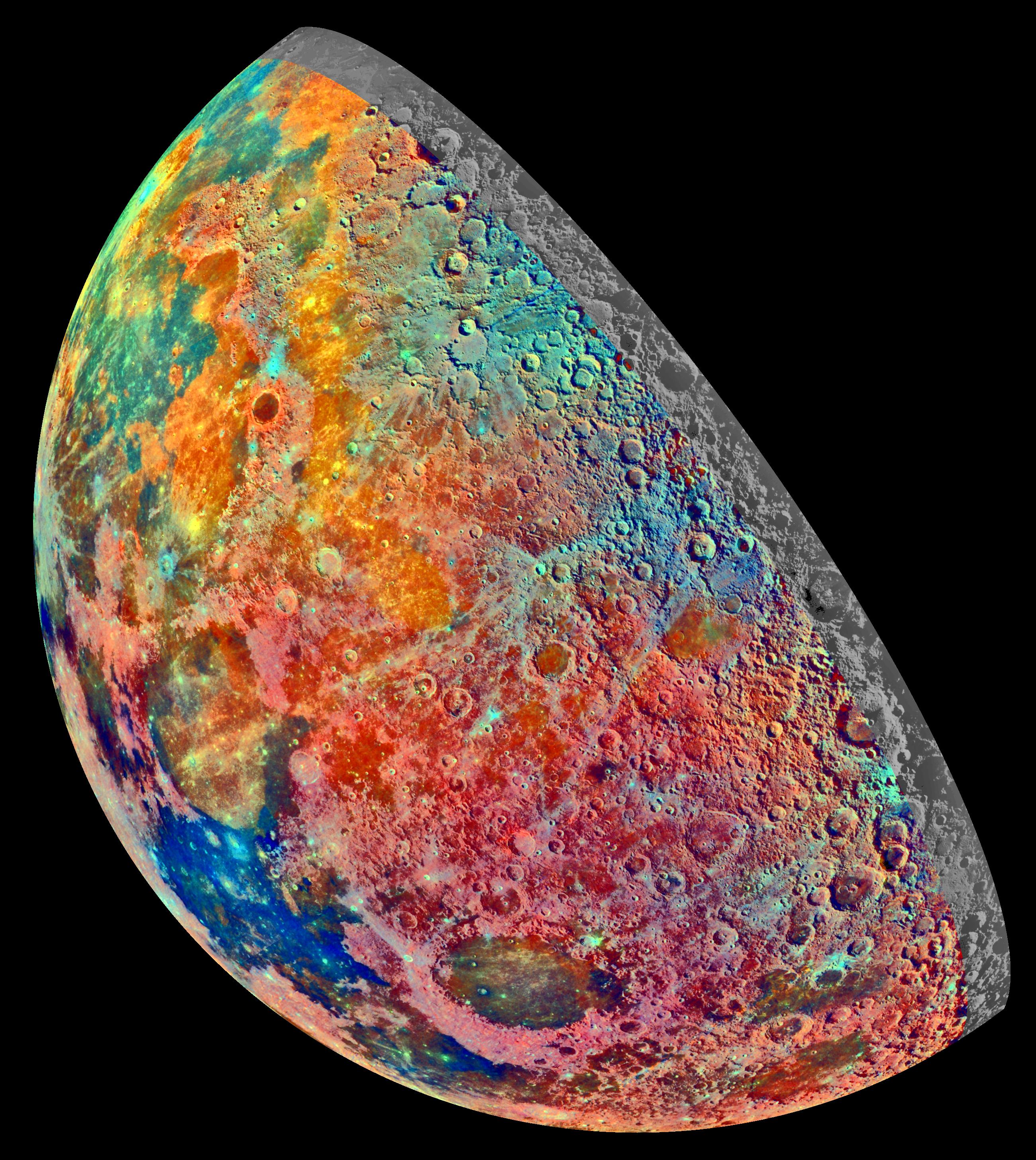
This false-color mosaic was constructed from a series of 53 images taken through three spectral filters by Galileo's imaging system as the spacecraft flew over the northern regions of the Moon on December 7, 1992. The part of the Moon visible from Earth is on the left side in this view. The color mosaic shows compositional variations in parts of the Moon's northern hemisphere. Bright pinkish areas are highlands materials, such as those surrounding the oval lava-filled Crisium impact basin toward the bottom of the picture. Blue to orange shades indicate volcanic lava flows. To the left of Crisium, the dark blue Mare Tranquillitatis is richer in titanium than the green and orange maria above it. Thin mineral-rich soils associated with relatively recent impacts are represented by light blue colors; the youngest craters have prominent blue rays extending from them. The monochrome band on the right edge shows the unretouched surface of the moon. The Galileo project, whose primary mission is the exploration of the Jupiter system in 1995-97, is managed for NASA's Office of Space Science and Applications by the Jet Propulsion Laboratory.

Source: http://photojournal.jpl.nasa.gov/jpeg/PIA00131.jpg
TIFF Version: http://photojournal.jpl.nasa.gov/tiff/PIA00131.tif
NASA Photojournal Catalog Page: http://photojournal.jpl.nasa.gov/catalog/PIA00131