Monday, January 25, 2010

Forty years after Apollo 13 at KSC


Having barely survived the aftermath of the tank explosion resulting in the only aborted manned lunar landing, after swinging around the Moon and using their lunar module's descent rocket to accelerate their lifeboat configuration into a proper return trajectory, before encountering Earth's atmosphere at 40,000 kilometers per hour, the crew first undocked from the LM and then jettisoned the Service Module. Only then were they able to see how close their ordeal came to ending at the very start. The explosion had ripped away entire panels on the SM and warped the fragile superstructure. As they re-entered Earth's atmosphere it still remained to be seen whether the Command Module's heat-shield had been damaged. Though the scene above was described by the exhausted crew to anxious Houston, nearly a week passed after the crew of Apollo 13 was safe on the ground before the above picture was available to the world [NASA/Apollo 13].

Jason Rhian
Examiner

It was called NASA’s “successful failure” and it marked one of the most trying points in the space agency’s history. Apollo 13 tested the resolve of NASA’s young engineers and astronauts as never before the heroic efforts of these space pioneers would go down to write NASA’s finest hour. Now, on the fortieth anniversary of the near-loss of the Apollo 13 crew, the Astronaut Scholarship Foundation is celebrating the safe return of the crew at Kennedy Space Center in Florida.

The Apollo 13 saga began with the liftoff of the mighty Saturn V rocket at 13:13 p.m. (EDT) on April 11, 1970. Two days after launch, a command was given to stir the oxygen tanks and what followed was one of the most dramatic moments in manned spaceflight history. An explosion occurred and the crew and mission managers on the ground had to scramble to ensure the safe return of the crew. Through seat-of-the-pants flying and ingenious technical innovations, the crew was brought home safe and sound. To show how great an impact this mission had, to date it is the only Apollo mission to have a big-budget Hollywood movie made about it.

Not even Apollo 11 can make that claim.

Read the article HERE.

Sunday, January 24, 2010


Just past First Quarter, Earth's Moon rises into a clear South American equatorial sky over the latest Ariane V, posed for launch [Janvier - EnjoySpace]

White House wants outsource of NASA work

Andy Pasztor
Wall Street Journal

The White House has decided to begin funding private companies to carry NASA astronauts into space, but the proposal faces major political and budget hurdles, according to people familiar with the matter.

The controversial proposal, expected to be included in the Obama administration's next budget, would open a new chapter in the U.S. space program. The goal is to set up a multiyear, multi-billion-dollar initiative allowing private firms, including some start-ups, to compete to build and operate spacecraft capable of ferrying U.S. astronauts into orbit—and eventually deeper into the solar system.

Read the full story HERE.

Friday, January 22, 2010

LROC: Pyroclastic Deposit


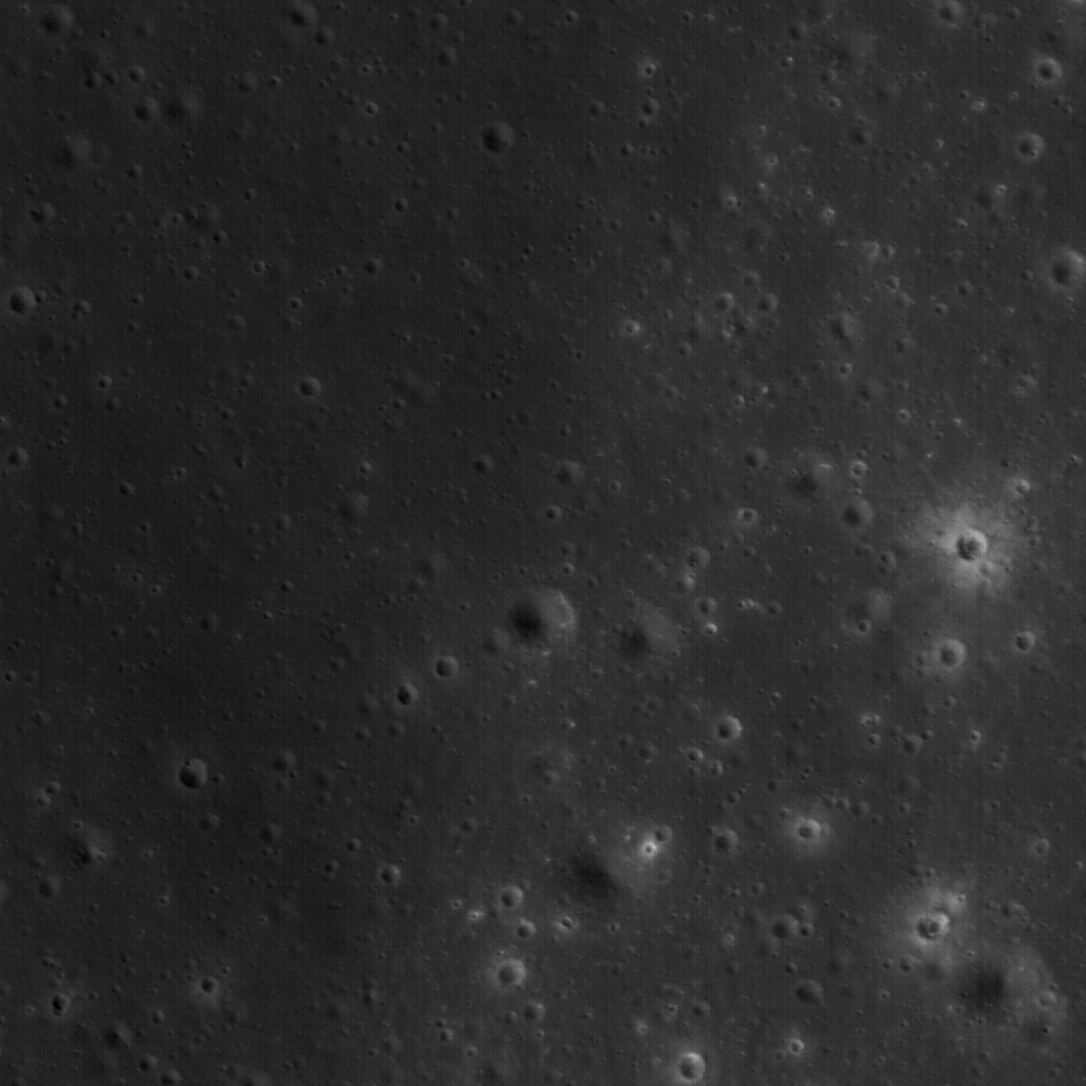
NAC Frame M111945148R. Part of the vast pyroclastic deposit near a Constellation Program Region of Interest located on the Aristarchus plateau is visible in this image. View is 537 m across [NASA/GSFC/Arizona State University].

Constellation Areas of Interest -
Aristarchus (2)

Lisa Gaddis
LROC News System

A typical view of the lunar surface? Hardly! This NAC frame (537 m across) reveals a dark, fine-grained pyroclastic deposit that has mantled older units, including flat mare deposits (at left) and nearby knobs of highland materials (at right). This site (Aristarchus 2) is located in the northwest region of the Aristarchus Plateau, within the most extensive deposit of pyroclastic materials on the Moon. The Constellation objectives here (Aristarchus 2) are more focused on resource potential, whereas Aristarchus 1 was selected more on the basis of geologic diversity.

At Aristarchus 2, some areas of the mantling deposit are estimated to be 10 to 20 meters in thickness. In the small area shown in the above image, the deposit is much thinner (likely only a meter or two deep). The bright-rayed crater at right-center (15 m diameter) has penetrated the mantle and exposed fresh, light-colored rocks typical of the lunar highlands. Many of the craters at left, although similar in size to the bright-rayed crater, have uncovered only dark materials that are slightly lighter in color than the pyroclastic mantle. Such exposures of rock by fresh craters provide some of the best clues to the composition and distribution of covered units and help to reconstruct the history of events that created the deposits we see.

Lunar pyroclastic deposits are formed by explosive eruption of basaltic magma and are thought to be associated with early stages of eruption of the mare deposits that fill impact basins across the near side. The deposits appear fine-grained and often very dark, and they have been called "mantling deposits" because they drape over and obscure underlying terrain. This mantling effect is similar to what you see after a deep snow: normally sharp edges of tables, chairs, and cars are now smoothed and subdued. The same effect happens under a blanket of fine ash.

Pyroclastic mantling deposits were sampled by the Apollo astronauts at several sites on the Moon, and in particular a deposit of submillimeter-sized orange glass and crystallized beads was discovered near Shorty Crater by Astronaut Harrison "Jack" Schmitt in the Taurus-Littrow Valley during the Apollo 17 mission. The beads at Apollo 17 formed from magma that originated ~400 km deep within the Moon and erupted more than 3.6 billion years ago.

Pyroclastic deposits are fascinating to lunar scientists because of the possible economic and engineering value of the volatile and metallic elements identified on and within their component beads. The beads have trapped solar wind hydrogen and Helium-3, and enrichments of volatile elements such as sulfur, lead, fluorine and zinc have been measured on their surfaces. Pyroclastic deposits are typically rich in iron oxides and also have widely varying amounts of titanium oxide, commonly present as the mineral ilmenite. Areas with pyroclastic deposits are likely to feature prominently among future exploration sites on the Moon and are a key enabler for large-scale human lunar habitation. Thus, it is important that we learn as much as we can about them. Where are they, how thick are they, and do compositions vary within a deposit and from deposit to deposit?

For more information on LROC's observation campaign for the Constellation Program regions of interest read this Lunar and Planetary Science Conference abstract, and visit the LRO Science Targeting Meeting website (look for the baseball card summary sheets for each site: part 1, part 2).

Explore the rich resources of the Aristarchus plateau for yourself!

Digital Terrain Model of Orientale Basin

From Proclus impact survey debris survey using Google Moon

Does this coelis, south of Proclus, really exist? Or is it more likely an error in the Digital Elevation Model? A casual census of available LRO Narrow-Angle Camera adds evidence to both arguments for and against such features elsewhere, though not yet this particular 800 meters tall and 1200 meter wide, at the base, formation which seems to be just barely within the resolution of the Apollo 15 high-sun metric camera photography. Whether this particular anomalous feature really exists or not, before 2010 is over it is likely many such features will be discovered that were beyond earlier orbital surveys.

The Lunar Reconnaissance Orbiter Camera (LROC) team at Arizona State University is owed a huge debt of gratitude for going above and beyond, literally, in sharing at least some of what has been discovered in unprecidented detail on the Moon by the LRO's narrow-angle camera (NAC).

LROC principal investigator Mark Robinson deserves some sort of Webby Award for sharing subsets of commission-phase LRO NAC imagery, particularly of the poles and eastern far side, hemisphere through the planetary data system. This test release has lunatics like us anxiously anticipating the Lunar and Planetary Conference in early March and the scheduled larger release of LRO data later that month.

It's hoped by that time the interested public and lunar science community will then be able to get a very long anticipated closer look at certain features on the Moon that have always been tantalizingly beyond the best resolutions.

Recently the LROC News System at Arizona State has begun sharing more of the Wide-Angle Camera (WAC) images, after redesigning their website, and this past week the team released something unexpected.

It appears the Laser Altimeter detail that will also soon be available from LRO will be complimented greatly by additional digital terrain modeling made possible by the LROC WAC. It's stunning, certainly, but still just hints at how our understanding of the Moon should soon match the true state of the art.


A Digital Terrain Model ("DTM") of the large Orientale Basin (1100 km diameter), located on the western hemisphere of the Moon, produced from stereo images obtained by LROC's Wide-Angle Camera. The image shows the hill-shaded, color-coded DTM with heights varying from approx. -4,700 meters to 9,400 meters. The small white boxes are areas without WAC coverage [NASA/GSFC/Arizona State University/ DLR].

Juergen Oberst
LROC News System

How was the Terrain Model created?

LROC's wide angle camera (WAC) has a ground resolution of approximately 100 m/pixel from LRO's nominal orbit altitude of 65 km and is taking image swaths 70 km wide along LRO's ground-track. Therefore, images from adjacent orbits show substantial overlap and strong stereo effects in the overlapping images.

Image overlap amounts to approximately 50% near the equator. Using sophisticated so-called "photogrammetric" techniques and computer software, a terrain model can be computed. Several hundred WAC images were combined to form this model. It is a subset of an almost global model, which is currently under construction and which will consist of more than 10,000 WAC images. This particular terrain model was produced using a software system that was originally developed by the German Aerospace Center (DLR; English version) for the High Resolution Stereo Camera (HRSC) on the European Mars Express Mission.

Read the rest of the release HERE.

Thursday, January 21, 2010

Aldrin is 80


Ian O'Neill
Discovery News

On July 20, 1969, Buzz Aldrin became the second man to set foot on the Moon, following mission commander Neil Armstrong. That historic moment was over 40 years ago. Today, Aldrin is celebrating another milestone, his 80th birthday.

Although the famous Apollo 11 mission was over four decades ago when NASA was in its infancy, Buzz continues to be very vocal in matters of human spaceflight. He is an outspoken critic of spaceflight policy and an expert in communicating all things space to the public.

INTERVIEW: Find out what Buzz had to say to Discovery News correspondent Irene Klotz during the Apollo 11 anniversary in July 2009.

Read the Interview HERE.

Space Shuttle demise hits Brevard County in Florida

Jerry Hart and Ryan Flinn
Bloomberg

Laurilee Thompson says her Dixie Crossroads seafood restaurant near Florida’s Kennedy Space Center will lose $50,000 a year in tourist business after the space shuttle flies for the last time in September. She’s not the only taxpayer in Brevard County to feel pain.

Local unemployment climbed to almost 15 percent after Apollo lunar launches ended in 1972. Now Brevard, Florida’s 10th-most populous county, where per capita income is already 8.3 percent less than the state average, is bracing for another blow as the U.S. shifts to moon and Mars flights from orbital missions.

Contractors led by Lockheed Martin Corp. and Boeing Co. will cut 7,000 Florida jobs, almost half the nationwide shuttle workforce that stretches to Alabama, Texas and California. Brevard, on the Atlantic coast, 40 miles (64 kilometers) east of Orlando, got $1.8 billion of the $2 billion the space program injected into the state in 2008, according to a National Aeronautics and Space Administration report. County borrowing costs rose about 2 percent since November after some of its bonds were downgraded by Fitch Ratings on concern over rising unemployment and falling revenue.

“It’s a perfect storm,” said Lisa Rice, president of Brevard Workforce, which administers the Aerospace Workforce Transition Program, a county retraining agency for shuttle employees facing dismissal. “You have the economy going down, the shuttle retiring and defense contracts decreasing.”

Read the feature article HERE.

Wednesday, January 20, 2010

LROC: The Cobra Head


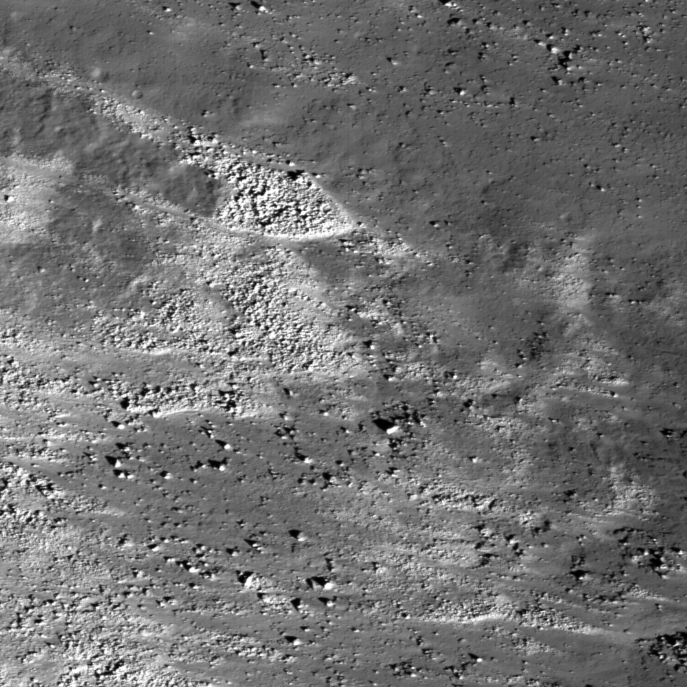
Eastern slope (right to left is downhill) of the Vallis Schröteri, "Cobra Head". This feature is located in the western portion of a Constellation Program region of interest on the Aristarchus plateau. The slopes of the Cobra Head are boulder-rich and display albedo variations - bright to dark. The patterns of debris and flows on the slopes are evidence for mass-wasting and landslides that expose a variety of rocks. Image width is 3.7 km, pixel width is 0.51 meters, from NAC frame M111918050R [NASA/GSFC/Arizona State University].

Constellation Areas of Interest -
Aristarchus (1)

J. Stopar
LROC News System

The Aristarchus plateau has fascinated lunar observers since before the space age. Its odd shape and low and high albedo extremes immediately draw your attention. Superimposed on the plateau is a spectacular channel (or rille), and the very young Aristarchus crater (regional overview). Aristarchus crater is the largest impact crater on the plateau and is one of the highest reflectance (in fact, it is blindingly bright in a telescope) features on the Moon. The plateau itself is surrounded by the lava flows of Oceanus Procellarum, and the whole region has a high concentration of sinuous rilles.

The largest of these is Vallis Schröteri, which is also the largest sinuous rille on the Moon. Finally, the plateau is almost completely covered by one of the largest lunar regional pyroclastic deposits. Large pyroclastic deposits are a potential resource for useful elements like hydrogen, oxygen, iron and titanium. Thus, due to its geologic complexity and resource potential, the Aristarchus region is naturally of interest to the Constellation Program and future lunar missions.

The head of Vallis Schröteri, a feature also known as the "Cobra Head", consists of a deep pit, which is of great interest to scientists. The Cobra Head is thought to be the source vent of a tremendous outflowing of lava that flowed across the plateau and formed the rille. Exposed in this vent are lava flows, pyroclastic material, and small bits of white rocks. The white rocks are pieces of the underlying crust most likely composed of anorthositic (highland) rocks. Much of this material was excavated by the impact that formed Aristarchus Crater and was brought to the surface from great depths.

These white rocks may be of a unique crustal composition representing late-stage subterranean magmatic activity. Rocks that form last from a magma body often have rare compositions enriched in incompatible elements. The elements are labeled incompatible because they do not easily combine with other elements and thus concentrate in the last remaining melt. Therefore, the last rocks to freeze out of a magma have high levels of these incompatible elements. Sampling such rocks will provide insights into lunar magmatic evolution and the bulk composition of the mantle.


The Cobra Head of Aristarchus Plateau in full sunlight as seen by Hubble- part of a larger examination of the links between lunar albedo and the geologic composition of the Moon's surface completed from Earth orbit using the Hubble Space Telescope. One of the many reasons Aristarchus is the most reported location of transitory phenomena is the blinding reflection from relatively fresh materials uncovered by the impact that created nearby Aristarchis crater, by far the brightest part of the larger, rectangular Aristarchus formation [NASA, ESA and J. Garvin (NASA/GSFC)]


LROC Wide-Angle Camera (WAC) mosaic centered on the Aristarchus Plateau; the Cobra Head is indicated with white arrow, a small portion of the rim of Aristarchus crater is just visible on the lower right, "H" indicates center of Herodotus crater (35 km diameter). M111918011CE, 605 nm in red, 567 nm in green, 415 nm in blue, image width ~55 km, north is up.

NAC image M111918050R, centered at 24.82N, -49.12E, shows a portion of the eastern wall of the Cobra Head. These slopes are covered with boulders and debris that slid down the walls. The patterns on the slopes are evidence for downslope movement (landslides and/or creep). "Flow" is from right to left, with boulders accumulating in local "bars" such as the one in the center of the image. The slope is scoured by the movement of boulders. The rocks exposed in the rille exhibit large brightness contrasts, some being very dark
and others very bright.

What is the origin of the bright material? Some of the brightness is a function of steep boulder faces oriented towards the Sun. Even dark rocks such as basalt can exhibit bright Sun-facing facets. Most of the local material here is basaltic, having originated in the huge Cobra Head vent at the head of the 140-km long Vallis Schröteri. To the east (right) of this image is the Aristarchus Crater, which has some of the brightest ejecta of any crater on the Moon. Some of that bright ejecta material is among the boulders that have moved down this slope as the steep rim gradually collapsed over time.

Explore the Aristarchus (1) Constellation Program region of interest for yourself, and imagine what it would be like to look out over Vallis Schröteri, the Lunar Grand Canyon.

Monday, January 18, 2010

NASA applys low-cost lessons to LADEE

Horizon glow, as televised from north of Tycho by Surveyor 7 during a long lunar night in 1968, the first dramatic hint of many that the Moon's submicron dust made up a dynamic component of the lunar exosphere. The Apollo missions to the lunar surface would further demonstrate the challenge to lunar exploration safety presented by electrostatic dust whose origins are thought to be a direct result of the persentent "gardening" of the lunar surface by micrometeorite bombardment and radiation. The LADEE mission is designed to definitively determine those dynamics with a mission beginning in late 2012.

Michael Mecham
Aviation Week

NASA’s first use of a low-cost, modular spacecraft design will be put into an unusually low orbit of the Moon to sample its atmosphere and dust and create a profile that will be useful for studies throughout the Solar System.

The Lunar Atmosphere Dust Environment Explorer (Ladee) is still in the early days of mission and science planning but is booked for an Oct. 28, 2012, liftoff on an Orbital Sciences Minotaur V from NASA’s Wallops Island, Va., space complex. It will be the debut of the five-stage solid propellant Minotaur V as a low-cost alternative for planetary missions.

Ladee is the first application of NASA Ames Research Center’s Modular Common Bus, a tiered satellite development program that aims for all-inclusive costs of as little as $50 million for simple missions (AW&ST Jan. 5, 2009, p. 32). With four tiers, Ladee is more complex than that; its budget is $200 million.

The project will rely heavily on the commercial off-the-shelf (COTS) systems and instruments approach that is basic to the low-cost/quick-build common bus concept.

The first contract has gone to Space Systems/Loral to build a propulsion system derived from its signature 1300-series communications satellite platform. Ladee will circle the Moon’s equator at a 5-deg. inclination at a nominal altitude of just 50 km. (31 mi.), lower than any previous lunar satellite’s planned orbit.

Read the article HERE.

Sunday, January 17, 2010

Friday, January 15, 2010

LROC - The Floor of Tycho


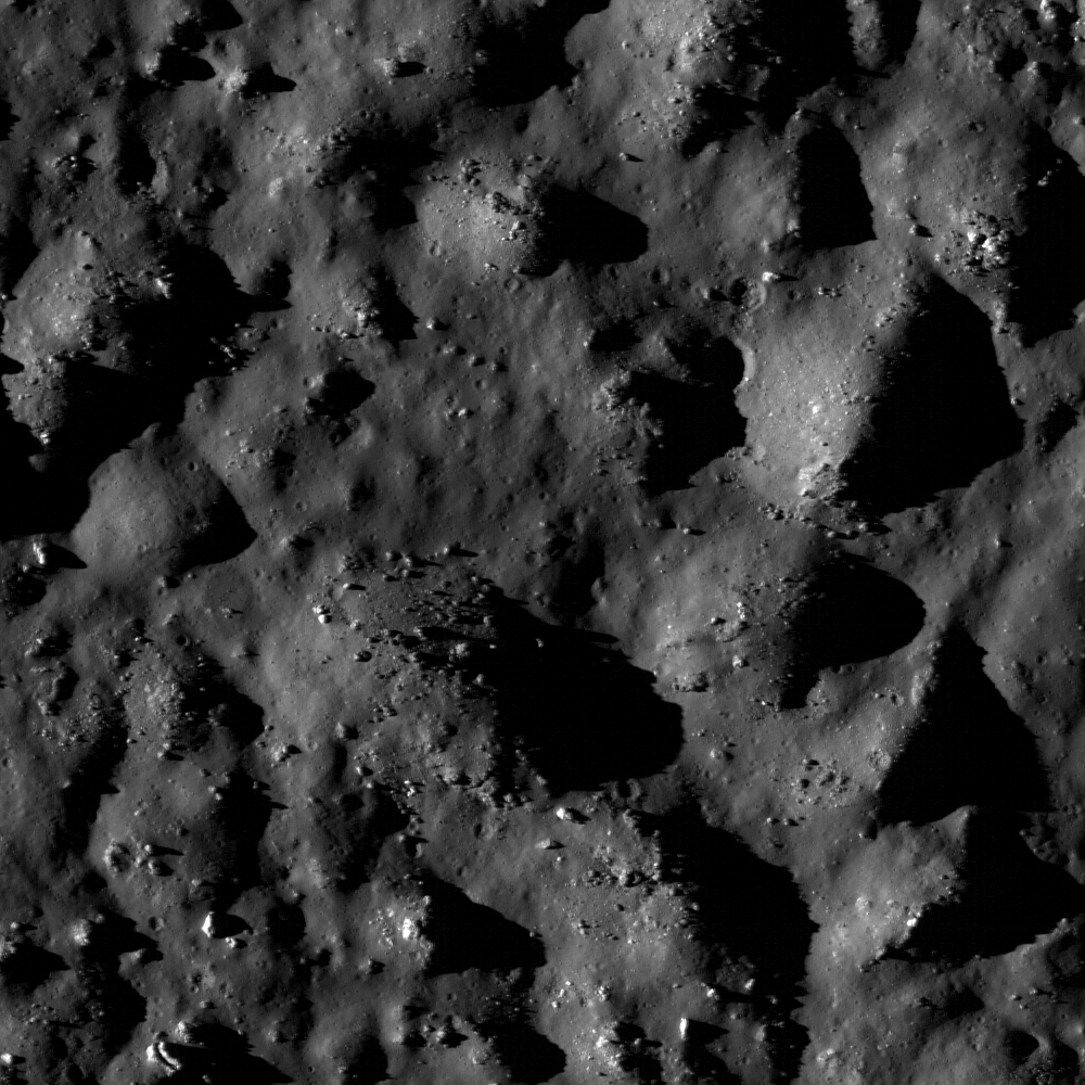
Boulders and impact melt line the floor of the 85-km-wide crater Tycho, potential site for future human exploration. Scene width is 620 m [NASA/GSFC/Arizona State University].

Constellation Program Region of Interest

Brett Denevi
LROC News System

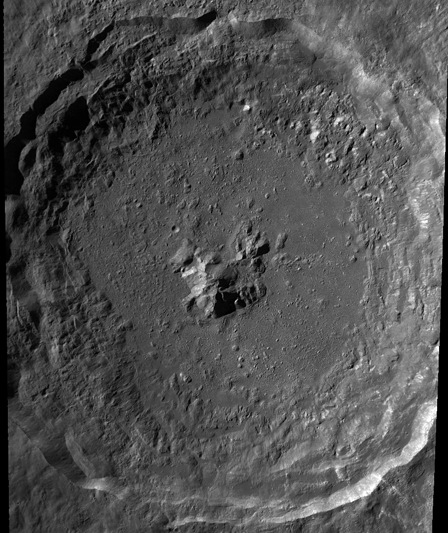
Tycho crater is an one of the most prominent craters on the Moon - it appears as a bright spot in the southern highlands with rays of bright material that stretch across much of the nearside. Its prominence is not due to its size: at 85 km in diameter, it's a just one among thousands of this size or larger. What really makes Tycho stand out is its relative youth. It formed recently enough that its beautiful rays, material ejected during the impact event, are still visible as bright streaks. All craters start out looking like this after they form, but their rays gradually fade away as they sit on the surface, exposed to the space environment which over time darkens until they fade into the background.


LROC Wide-Angle Camera image of Tycho. The proposed Constellation site is to the North of the crater's central peak (see Kaguya Terrain Camera Image below [NASA/GSFC/Arizona State University].

How old is Tycho? Because the impact event scattered material to such great distances, it's thought that some of the samples at the Apollo 17 landing site originated at the Tycho impact site. These samples are of impact melt glass, and radiometric age dating tells us that they formed 108 million years ago. So if these samples are truly from Tycho, the crater formed 108 million years ago as well. Though this may still seem old, compared to the 3.9 billion-year age for many large lunar craters, Tycho is the new kid on the block. Scientists would love to be able to confirm the age of crater by directly sampling material from within the crater. This would help us learn more about not just when Tycho formed, but the ages of terrains on other planets throughout the solar system. Planetary surfaces are dated by counting the number of craters on the surface, and comparing that number to the number of craters that formed on a surface for which we know the age by actually sampling the rocks. The problem is, there aren't that many places for which we've sampled the rocks, and confirming the age of Tycho would help date younger surfaces, which are not well sampled.

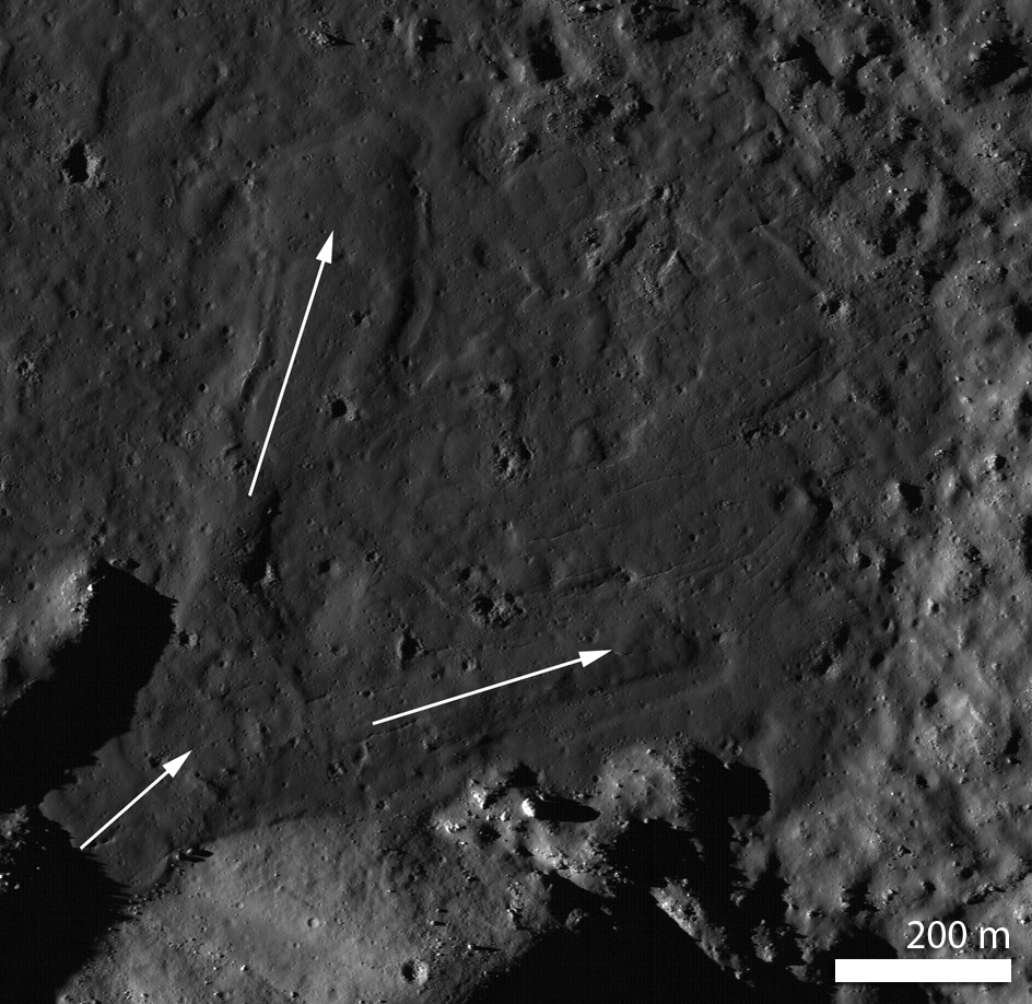
Tycho is also of great scientific interest because it is so well-preserved, it is a great place to study the mechanics of how an impact crater forms. The Constellation site is on the floor of Tycho, near its central peak. The peak is thought to be material that has rebounded back up after being compressed in the impact, and though it's a peak now, it originated at greater depth than any other portion of the crater. The floor of the crater is covered in impact melt - rocks that were heated to such high temperatures during the impact event that they turned to liquid, and flowed across the floor. In the image below, impact melt flowed downslope and pooled, where it cooled.


Rock melted by the Tycho impact event flowed across the floor of the newly-formed crater in the direction indicated by arrows before it solidified into a rock made up of a mixture of minerals and glass. Resolution is reduced by a factor of two [NASA/GSFC/Arizona State University].

The LROC NAC images make clear why this fascinating crater was chosen as one of the Constellation sites. Browse the full NAC image here.

Below: Crop of a frame from a sweeping terrain camera video imaged by Japan's Kaguya (SELENE-1) lunar orbiter in 2008.


Wednesday, January 13, 2010

Magnificent Aitken


North of the equator on the Moon's Far Side, Aitken stands out as a landmark, the furthest border of 4 billion year old South Pole-Aitken (SPA) Basin, 2500 kilometers from its nearest rim spilling 200 kilometers over onto the Near Side past the Moon's south pole [NASA/Apollo 17/ASU-Apollo Image Archive].


A lobate scarp in the mare basalts of Aitken crater on the lunar farside (arrows). Aitken crater is one of the fifty regions of interest in NASA’s Constellation Program. The smooth mare basalts that flooded the floor of Aitken crater are relatively few on the lunar farside. Mare basalts often have wrinkle ridges and lobate scarps, tectonic landforms that express contraction of the volcanic flows. Future astronauts who might visit Aitken crater will explore this landform in search of clues to how this and other lobate scarps form. Image width is 4.5 km, NAC frame M103374879RE [NASA/GSFC/Arizona State University].

Tom Watters
LROC News System

Aitken Crater Constellation Program
Region of Interest

Mare basalt-filled craters (basins) are few in number and small in size on the farside. Aitken crater is about 135 km-in-diameter and is located on the northern rim of the South Pole-Aitken basin, the largest preserved basin on the Moon. The crater has a central peak and much of its original floor has been buried by younger mare basalt. Enigmatic albedo features called swirls are found on the floor of Aitken. Scientists are not sure how these features formed, but think they may be related to weak variations in lunar magnetism. Hummocky floored craters, impact craters formed in Aitken's mare basalt infill, have strange, bulbous hills. Their origin is also not well understood. These are some of the reasons why a Constellation Program region of interest is located within Aitken crater. The wealth of unusual features in Aitken make it an exciting location for exploration by astronauts.


Basalts, swirls, and hummocky floored craters all populate the floor of Aitken crater. Mare basalts lapped up against the south half of the central peak (center of image), burying much of the original floor. The swirls can be seen just west of the central peak as bright and dark mottling, their origin remains a mystery. Arrow indicates location of today's featured image; LROC WAC mosaic, image width ~36 km [NASA/GSFC/Arizona State University].

The Moon, like Earth and the other terrestrial planets and many of the other solid bodies in the Solar System, exhibits tectonic landforms. Tectonic landforms result from forces that have either contracted and pushed crustal material together, or extended and pulled crustal material apart. Most of the tectonic landforms on the Moon are found in and around the nearside mare basins. Two contractional tectonic features, wrinkle ridges and lobate scarps, are found in mare basalts, volcanic rock that flooded the floors of the nearside impact basins after their formation. The forces that created these landforms in the mare basins are thought to be from the weight of the dense basalts that caused them to subside and contract.

Like the mare basalts in nearside basins, those in Aitken have been deformed resulting in wrinkle ridges similar in form to those on the nearside, although much smaller in scale. Near the southeastern rim of Aitken, close to the contact between the mare basalts and hummocky crater rim material, is a linear, low-relief scarp. This scarp, about 3 km in length, is very similar in size and morphology to lobate scarps found elsewhere on the Moon. Lobate scarps are relatively young landforms thought to be the surface expression of thrust faults, formed when an upper fault block is pushed up and over a lower fault block.

Outside of a mare basin, what is the origin of the tectonic forces that formed this lobate scarp? The thickness of the mare basalts in Aitken crater is small compared to the thickness in the much larger nearside basins. Is there enough mare basalt to cause subsidence and contraction? The contraction that formed the lobate scarp in Aitken crater may be from a much broader and deeper source. Lobate scarps are the most common tectonic landforms in the lunar farside highlands. The forces that formed these thrust fault scarps may come from slow cooling of the lunar interior that led to global contraction. Thus, the lobate scarp in the mare basalts of Aitken is likely due to thermal contraction of the Moon.

Astronauts exploring and sampling the farside mare basalts in Aitken crater would surely plan a trip to this lobate scarp. Examination of the base of the scarp might reveal a subtle break and offset of the basalt regolith or soil that could be evidence of the underlying thrust fault, providing important insight into when the lobate scarp formed.

Explore the Aitken crater Constellation region of interest for yourself and look at previously released images showing another lobate scarp and several wrinkle ridges.

Friday, January 8, 2010

Moon's perfume comes from our Sun

Map of moderated neutrons over the whole Moon. Lunar Prospector data. [Elemental content from 0 to 500 keV neutrons: Lunar Prospector results, Genetay et al. / Planetary and Space Science 51 (2003) 271 – 280].

A lot has happened, suddenly it seems, since the $60 million Lunar Prospector mission first mapped fast and slow neutrons reflecting off the Moon in 1998. Five years after the small, optically blind spacecraft was deorbited into Shoemaker crater, in permanent darkness near the lunar South Pole in a forlorn last-minute attempt to accomplish what LCROSS eventually would do a decade later.

By late 2009, scientists around the world had put one and one and one together, beginning with the Russian-built neutron detector aboard Lunar Prospector in 1998, data originally thought erroneous that was detected during a sling-shot maneuver accelerating Cassini on its way to Saturn with more pieces of the puzzle collected by India's lunar orbiter Chandrayaan-1. Among other things, sniffing the Moon has shown us the Moon is wet in more ways than one, wettest in its Permanently darkened Cold Spots and at the equator. It's becoming more and more clear that the dusty, radioactive lunar exosphere is a very dynamic place.

The STEREO solar satellites only very recently confirmed the presence of neutral hydrogen in the solar wind, so the driving force behind 99 percent of the Moon's most dynamic processes and its volatiles is none other than our modest yellow dwarf Home Star. The heavier elements patiently pile up perhaps mostly from bombardment by far more energetic cosmic rays.

Put more simply, Larry O'Hanlon of Discovery News has called our remote sensing a sniffing of the Moon's solar-driven perfume, in this case calling attention to yet another player in this drama and an experiment early on in the mission of Japan's lunar orbiter Kaguya, monitoring radio signals to and from it's two sub-satellites as they rose into line-of-sight up over the horizon in 2007 and 2008.

The moon's whiff of an atmosphere has been sniffed by a Japanese spacecraft under very special conditions and confirmed as coming largely from sunlight brutally hammering the lunar surface.

Using the very first direct measurements of the moon's "exosphere" as the moon passed through the streaming tail of Earth's protective magnetic field, researchers were able to watch the short-lived and ever-changing exosphere in the absence of the hot, magnetized solar wind.

What they found confirmed that it's really just powerful ultraviolet light knocking beat-up atoms, or ions, off the lunar surface and manufacturing the bulk of the weak lunar perfume.

This discovery is important for several reasons, explains NASA lunar scientist Menelaos Sarantos. One is that it could help interpret what kinds of minerals are on the moon's surface.

"What comes out [as exosphere] more or less tells you the mineralogy of the surface," Sarantos said.

The ions and how they change over time also provide direct evidence of how much of a beating the lunar surface is taking, which is invaluable information for anyone hoping to house humans on the moon in the future.

"If you want to build a lunar base or put humans on the surface for any time," Sarantos said, "you want a well-defined radiation environment."

Read the Discovery News feature HERE.

Plannning our Phases on the Moon

Aaron L. Gronstal
Moon to Mars
Astrobiology

As space agencies around the world gear up for a return of humans to the Moon, researchers are beginning to outline important scientific priorities. A new study at an impact crater in Canada is helping mission planners develop the most effective methods for exploring the lunar surface.

Read the feature report HERE.

Boston.com features LROC Gallery


The Lunar Reconnaissance Orbiter's (LROC) Narrow Angle Camera swept up this high-sun image of a fresh crater in the Meskelyne region in south central Mare Tranquillitatis, 326 km east-northeast of Tranquility Base, in its 1196th orbit, Sept. 30, 2009 [M108992058RE - NASA/GSFC/Arizona State University]

Images from the Lunar Reconnaissance Orbiter
Boston.com

NASA's Lunar Reconnaissance Orbiter (LRO) was launched in June 2009 and is currently orbiting the Moon around its poles at a low altitude of just 50 kilometers (31 miles). The primary objective of the LRO is to prepare for future lunar exploration, scouting for safe and compelling landing sites, potential resources (like water ice) and more. The high-quality imagery used in the mapping of the lunar surface is unprecedented, and a few early images have included detailed overviews of the landing sites of several Apollo missions some 40 years after they took place. LRO is now on a one year mission with possible extensions of up to five years. Collected here are several recent LRO images, and a few then-and-now comparisons of Apollo landing sites.

(18 photos total)

China space program shoots for moon

John J. Tkacik Jr.
Washington Times

In November, Chinese air force commander Gen. Xu Qiliang observed that "competition between military forces is now turning toward the realm of space, [and] military modernization is ceaselessly expanding into space."

But during his visit to Beijing a few days later, President Obama talked about "cooperation" rather than competition. In a joint statement with Chinese President Hu Jintao, the two leaders called for "a dialogue on human space flight and space exploration, based on the principles of transparency, reciprocity and mutual benefit."

China's aerospace industry firms - which for decades have supplied dangerous missile technologies and equipment to Iran, North Korea and Pakistan, and which have been sanctioned ceaselessly by four successive U.S. presidents for their transgressions - will find the United States in a new suppliant posture.

The atrophying U.S. space program suggests that America will be forced to cooperate with China in space, or else cede the high frontier of space to China altogether.

In October, a White House committee headed by former Lockheed Martin Chairman Norman Augustine, reported that without $3 billion in additional funding, NASA has no plan that "permits human exploration to continue in any meaningful way."

October's launch of the experimental Ares 1-X heavy lift rocket, while flawless, may well mark the end rather than the beginning of America's next-generation Constellation manned-space program. The space shuttle is scheduled for retirement this year and until Constellation gets off the ground, future American astronauts will rely on Russians - or Chinese - to get into orbit - if they want to get there at all. America's multitrillion-dollar deficits over the next 10 years are likely to dissuade the Obama administration from budgeting for Constellation until well after Mr. Obama leaves office, if then.

The Pentagon is clearly alarmed by the prospect. The chief of U.S. Strategic Command, Gen. Kevin Chilton, told reporters Nov. 3, "With regard to China's [space] capabilities, I think anyone who's familiar with this business ... would have to be absolutely amazed at the advancement that China has made in such a short period of time, whether that be in their unmanned program or the manned program."

Senior Chinese space officials have told their state media that China could be on the moon by 2022 at the outside. Other authoritative Chinese space engineers see a moon landing as a next step in the Tiangong program that will launch three Chinese space stations into Earth orbit between 2011 and 2015. In 2008, NASA scientists told the Bush White House that, with the technology currently available to the Chinese space program, Chinese cosmonauts could be on the moon by 2017.

NASA sees China's strategy for a manned lunar landing as launch vehicle intensive. While America's notional Constellation moon project centers on a single - and still unbuilt - Ares-V "superheavy" lift booster for a direct ascent to the moon and two "lunar orbit rendezvous" operations, China will likely opt for two complex "Earth orbit rendezvous" maneuvers.

This will require four "Long March V" rockets - in the same class as the Pentagon's Delta IV heavy lift launch vehicles - to put their cosmonauts on the moon. Launched in pairs over a two-week period from China's new Wenchang Space Center on the South China Sea island of Hainan, the four Long March Vs will each loft 26-ton payloads into low Earth orbits. The first mission will orbit the rocket for the translunar journey which will then join a second payload of an empty lunar module (LM) and its lunar-orbit rocket motor. Those first two unmanned payloads will rendezvous in Earth orbit and then fire off for the quarter-million-mile journey to the moon.

Once the unmanned LM is in a stable lunar orbit, the second pair of missions will be launched into Earth's orbit; the first with another translunar rocket motor and the second with a combined payload comprising the lunar orbiting module, a modified service module, an Earth re-entry module and the manned Shenzhou capsule with three Chinese cosmonauts.

NASA's experts understand the capabilities, talents - and intentions - of their Chinese counterparts perhaps better than anyone outside China and Russia. China's Long March V rockets are in development now; Russian space scientists now aid their Chinese counterparts in perfecting the Shenzhou class of manned vehicles - closely modeled on the rugged, tried-and-true Soyuz; China has also purchased Russia's spacesuit designs and the KURS and APAS rendezvous and docking systems.

In contrast, NASA has resigned itself to the realities that America's space shuttles will be decommissioned by 2010 and, while the test-launch of the Ares 1-X heavy lift booster was successful, the follow-on Constellation manned program does not have a budget that will get it off the blueprint tables. Nor is NASA staffed with the scientists needed to support it. The median age of NASA's manned space engineers is now over 55. Over a quarter are past retirement age. Meanwhile, China's average lunar probe engineer is about 33 years old and the Shenzhou manned-space program engineers average about 36.

China's space program also seems to have all the funding and resources it needs, partially due to the fact that seven of China's nine most senior leaders - the Standing Committee of the Chinese Communist Party Politburo - are themselves engineers.

China may already be the second-largest manufacturing power on Earth and possesses a highly advanced industrial infrastructure. It now has more than $2.3 trillion in excess foreign exchange holdings - adding another $300 billion just in the past nine months, equal the entire gross product of Argentina. And China's top universities are rolling in research money, possess the latest laboratory equipment, and have their pick of the most brilliant students.

In 2005, China produced 351,537 engineers, with at least a bachelor's degree, nearly double the United States figure of 137,437; and a healthy chunk of China top engineers get their doctoral training at American universities. For example, of the 99 doctorates in engineering awarded by the University of Virginia from August 2007 to August 2008, one third - 33 - went to scholars from Chinese universities.

To be sure, China's imaginative and capable aerospace engineers have devised quite workable spacefaring designs, and their access to Russia's space science has helped accelerate their progress. And what the Chinese can't buy from the Russians, or learn at America's top universities, they can still pilfer from U.S. industry.

In July, Dongfan Chung, a former stress engineer with Boeing, was convicted of economic espionage involving 300,000 pages of sensitive data, including information about the space shuttle and the fueling system for America's biggest booster rocket, the Delta IV. In his ruling, the judge in the case noted that Mr. Chung, a U.S. citizen, had decided "to serve the [People's Republic of China], which he proudly proclaimed as his 'motherland.' " In 2008, Shu Quan-sheng, an American physicist living in Virginia was convicted of transferring to the Chinese People's Liberation Army details of liquid hydrogen tanks for the Delta IV.

This combination of financial wealth, educational excellence, advanced technology and a penchant for plundering intellectual property has enabled China's space program to develop swiftly. In 2003, China's gained entry into the exclusive manned-space club previously restricted to the United States and Russia. By 2008, Chinese astronauts were taking space walks and buzzing tiny "BX-1" nano-satellites around their space capsules, a technology that puts them on the cutting edge of "space situational awareness" that America's military space assets still lack.

Beijing's political and military leaders alike foresee "competition" in space with the United States. They certainly plan to seize the high ground of low-Earth orbit and then will likely move to the even higher ground of moon landings perhaps before this decade is out. Judging from the past behavior of China's state-owned aerospace firms especially in their unseemly eagerness to proliferate ballistic missile technology to rogue states, it is unlikely that Mr. Obama can count on much "cooperation" with China in space - except on China's terms.

- John J. Tkacik, a retired Foreign Service officer, was chief of China analysis in the State Department's Bureau of Intelligence and Research during the Clinton administration.

MoonRise SPA sample-return mission and Washington University

Scientists on Earth know least of the oldest-known, largest-known and deepest impact basin on the Moon, South Pole-Aitken (SPA) Basin, stretching from it's mountainous rim between Earth and the lunar south pole on the Near Side nearly to the equator on the southern Far Side. Among the three New Horizon missions making the final cut in an announcement by NASA before the New Year is MoonRise, the first U.S. robotic lunar sample return scenario, under the direction of Washington University in St. Louis.

Nearly 40 years after the Apollo astronauts first brought samples of the Moon to Earth for study, researchers from Washington University in St. Louis are leading an effort to return to the Moon for samples that could unlock secrets of the early Solar System.

Known as MoonRise, the proposed Moon mission is one of three finalists now bidding to become NASA's next big space science venture, a $650 million mission that would launch before 2019.

The MoonRise lander, unmanned and robotically controlled, would scoop up about two pounds of pea-sized lunar rocks and return them to Earth for further analysis.

"The samples would provide new insight into the early history of the Earth-Moon system," said Bradley Jolliff, Ph.D., principal investigator for the proposed mission and research professor of Earth and Planetary Sciences in Arts & Sciences at Washington University.

The MoonRise mission targets the giant South Pole-Aitken (SPA) Basin, which spans from edge to edge nearly 2500 km, so named because it lies between the Moon's South Pole and Aitken Crater, just south of the Moon's equator. The SPA Basin ranks among the largest recognized impact structures in the Solar System.

Samples from the crater could answer questions about the bombardment history of the Earth-Moon system during the first 600 million years of Solar System history, at a time when life was first gaining a foothold on Earth.

"Determining the age of rocks formed during the impact event will allow scientists to test hypotheses for the cause and source of such giant impactors during the planets' formative years," Jolliff said. "The samples would also illuminate processes by which the crusts of planets form and by which giant impacts alter them.

NASA announced Dec. 29 that MoonRise would be one of three space exploration proposals considered for selection as the third venture in its ongoing New Frontiers space science program. New Horizons, the program's first mission, is expected to reach the Pluto-Charon system by 2014. The Juno mission, slated for launch in 2011, will explore Jupiter from pole to pole.

WUSTL's MoonRise mission is competing with a proposal from the University of Arizona at Tucson that would retrieve a sample from a near-Earth asteroid and another proposal led by the University of Colorado at Boulder to probe the atmosphere and crust of Venus.

"These are projects that inspire and excite young scientists, engineers and the public," said Ed Weiler, associate administrator for the Science Mission Directorate at NASA Headquarters in Washington. "These three proposals provide the best science value among eight submitted to NASA this year."

Each of the three proposal teams will receive about $3.3 million from NASA in 2010 to conduct comprehensive, 12-month studies documenting details of concept implementation underlying their proposed missions.

In 2011, after detailed mission implementation, feasibility, cost, management and technical plans are completed and reviewed, NASA will select one proposal for full development and launch. Mission cost, excluding the launch vehicle, is limited to $650 million.

Washington University's Department of Earth and Planetary Sciences has a rich history of involvement in NASA space missions and in the study of lunar samples — Apollo and lunar meteorites .

Department colleagues joining Jolliff as key members of the Moon mission are research professor Randy L. Korotev, Ph.D., and research scientist Ryan Zeigler, Ph.D.

Scientists are eager to explore the South Pole-Aitken region because it is thought to harbor rocks and melted material from deep in the Moon's crust, which are poorly represented in lunar samples retrieved by the Apollo missions. The last batch of Apollo Moon rocks arrived on Earth in 1972.

The MoonRise mission's scientific value is greatly magnified, said Jolliff, by the opportunity it poses to determine the ages of key impact events in Solar System history, a line of study now limited mostly to analysis of the Apollo lunar samples and meteorites found on Earth.

"What we have is a set of very testable hypotheses about the causes and effects of the pummeling by giant impactors that took place at a time when Earth's rock record holds very little information," Jolliff said. "This information is perhaps uniquely recorded in the ancient Moon rocks."

MoonRise also would make use of information gleaned from orbital spacecraft, including recent missions by European Space Agency's (SMART-1), the Chinese (Chang'e-1), the Indians (Chandrayaan-1), the Japanese (Kaguya), and the currently active US Lunar Reconnaissance Orbiter (LRO), to provide all of the information needed to select the best landing site.

MoonRise will be the first NASA mission to robotically return samples from another planetary body to Earth. Such a capability would be a precursor and a feed-forward demonstration for future sample return missions from Mars or other planetary bodies, according to Dr. Leon Alkalai, Manager of JPL's Lunar Robotics Exploration Program Office, and Capture Lead for the MoonRise proposal,

Jolliff is a co-investigator on the Lunar Reconnaissance Orbiter Camera system (LROC) that is currently imaging and investigating the Moon in ways that will enable the next generation of landers — human and robotic — to land safely anywhere on the Moon and to select the best sites for science.

The South Pole-Aitken Basin targeted by MoonRise is especially ripe for scientific exploration, according to lunar sample expert Korotev.

"This is the largest and oldest impact basin known on the moon," said Korotev. "The main goal of the mission is to determine how old it is."


Small rock fragments from an Apollo soil (left) and analysis of one such rock fragment in Korotev's gamma-ray detector lab in the WUSTL Department of Earth & Planetary Sciences.


Washington University is partnered with the Jet Propulsion Laboratory in Pasadena, CA, for project management, systems engineering, mission design, and navigation and operations. For the implementation of the flight system, WUSTL and JPL have teamed up with Lockheed Martin Space Systems Co. of Littleton, CO. Other partners include the Deutsches Zentrum für Luft und Raumfahrt (DLR) in Berlin, Mullard Space Science Laboratory, University College, London, and Malin Space Science Systems, San Diego, to develop camera systems for the spacecraft. Science partners for site selection, sample handling and analysis, and geophysics include the Australian National University; Brown University; College of Charleston; Harvard University; Institut de Physique du Globe de Paris; Johnson Space Center; Lawrence Livermore National Laboratory; the Lunar Geotechnical Institute; Marshall Spaceflight Center; Purdue University; US Geological Survey, Flagstaff; University of Arizona, Tucson; University of California, Los Angeles; University of Hawaii, Honolulu; University of Muenster, Germany; University of New Mexico; and the University of Western Ontario.

NASA's New Frontiers program seeks to enhance understanding of the Solar System by sending frequent space exploration missions to celestial bodies deemed most likely to hold clues about such issues as the formation of the Planets and the origins of life.

For more information about the New Frontiers Program, visit: http://newfrontiers.nasa.gov

LROC to feature the Constellation 50


Mare Moscoviense Constellation Site


A very subtle mare-highlands boundary in Mare Moscoviense on the lunar farside, near the center of the Constellation Program region of interest. The generalized geologic contact between the mare and the highlands has been highlighted (mare to the left, highlands to the right). Astronauts exploring this region could collect key samples from the farside basalts of Mare Moscoviense as well as materials from the surrounding basin massifs. Image width is 600 meters [NASA/GSFC/Arizona State University].


Samuel Lawrence
LROC News System

The primary mission of the Lunar Reconnaissance Orbiter is to collect the data necessary to enable the human exploration and development of the lunar surface. The instrument suite of the spacecraft, including LROC, was specifically designed with this overarching goal in mind.

Today, the LROC Team begins a new series of Featured Images highlighting the regions of interest for future human lunar exploration that we are imaging for NASA's Constellation Program.

There are fifty of these sites, which were selected prior to LRO launch based on expert input from the lunar science community and NASA engineers. For each of these fifty sites, the LROC Team is collecting a comprehensive set of image data, including observations for geometric and photometric stereo and complete nadir coverage (with repeat imaging at varying illumination). These images, and the associated information products derived from them (such as boulder distribution maps, slope maps, and digital terrain models), will be used by engineers and scientists preparing for the next generation of human lunar exploration. For more information on LROC's observation campaign for the Constellation Program regions of interest read this Lunar and Planetary Science Conference abstract, and visit the LRO Science Targeting Meeting website (look for the baseball card summary sheets for each site: part 1, part 2).

Lunar scientists have been studying the vast data return from the Apollo missions for almost forty years. As a result, much is known about the Moon. For example, we know how to leverage lunar resources to enable future human lunar habitation. Even so, there remains much that we do not know about the Moon. Accordingly, each of these fifty sites is associated with either an immensely compelling lunar science question or an Exploration-enabling resource that will be useful to future explorers, or both. However, these fifty sites aren't intended as actual NASA landing sites, but instead are representative locations whose study will provide mission planners and lunar scientists working on future human lunar exploration with lots of data for a comprehensive suite of interesting and relevant terrains all over the lunar surface. Having said that, each of these locations really would make a great place for the seventh (and the eighth, and ninth, and tenth...) human lunar landing and beyond as we prepare for the long-awaited return of astronauts to the lunar surface. We hope you enjoy these guided tours of some of the most fascinating places on the lunar surface - places where humans should be productively exploring, living, and working in the not-too-distant future.

Mare Moscoviense: Window to Farside Volcanism

It's clear from looking at pictures of the Moon that the nearside and the farside are very different from a geologic standpoint. The low reflectance, basaltic mare deposits dominate the nearside, whereas the bright deposits of anorthosite thought to be remnants of the Moon’s original crust dominate the farside. Mare Moscoviense is one of the few (and also the largest) deposits of mare basalts on the lunar farside.


Figure 1. Clementine 750 nm mosaics showing the lunar nearside and lunar farside, with the location of Mare Moscoviense highlighted [USGS/Arizona State University].


Why are there so many mare basalts on the nearside, but so few on the farside? Lunar scientists simply don't know the answer to that question, although we have some ideas. One idea is that the farside crust is simply thicker than the nearside crust, and the rising bodies of basaltic magma simply solidified before they were able to push through the thicker farside crust. However, we won't know for sure until we can get human explorers to the farside to collect samples, and that's where Moscoviense comes in. We know enough about the Moscoviense region from previous missions that we have a well-defined set of questions we can answer by sending human explorers. For example, the Lunar Prospector mission showed that there are relatively high concentrations of thorium in the Moscoviense basin. Thorium acts as a tracer for the lunar KREEP geochemical component found in abundance on the nearside but not on the farside. Understanding the extent and distribution of thorium in the basin may tell us about the global distribution of the lunar KREEP component and thus the evolution of the lunar mantle. We also know from the Clementine mission that the Moscoviense basalts are both iron and titanium-rich. Since basalts form by partial melting of the lunar mantle, sampling Moscoviense basalts provides lunar scientists with vital insights into how the lunar mantle on the farside differs from the nearside mantle, which in turn would help us to learn why mare basalts are so much rarer on the farside and provide key insights about the formation of all of the terrestrial planets, including Mars and Earth.

For these reasons, a Constellation region of interest is located within Mare Moscoviense. As you can see in Figures 2 and 3, the landing site is at the edge of Moscoviense, allowing would-be explorers to collect samples from both the mare basalts and the surrounding highlands terrain during their traverses. A previous LROC Featured Image also shows the Moscoviense-highlands boundary just a few kilometers south of today's image. The materials at the edge of the basin provide important insights into the formation of the Moscoviense basin itself. By exploring and sampling the Moscoviense region, we would date the basalt flows and definitively determine their composition. This sampling would allow us to determine how Moscoviense basalts differ from the nearside basalts sampled during Apollo. Directly determining the age of Moscoviense basalts with laboratory analysis provides important insights into the history of lunar volcanism by determining where the Moscoviense basalts fit in the Moon's volcanic history.


Figure 2. LROC WAC (Red=689, Green=566, Blue=415 nm) mosaic with the location of the proposed Constellation region of interest indicated with arrow [Arizona State University].


While the scientific goals of exploring the Moscoviense region are certainly important, no less important is access to key lunar resources. The lunar regolith (the broken-up rocks and impact products that make up the first 10 meters or so of the lunar surface) in this region is derived in part from the local titanium-rich Moscoviense basalts. This regolith material could be used for a variety of vital purposes, including the construction of human habitats, radiation shielding, or as feedstock for local resource utilization. Taking a longer view, titanium is an important industrial material on Earth, and it will be very important for indigenous lunar industrial development.


Figure 3: Twenty times downsampled mosaic of LROC NAC images M105887165LE and M105887165RE showing location of the Moscoviense Constellation region of interest; image is 77.6 km tall by 14.5 km wide [Arizona State University].


Explore the Mare Moscoviense Constellation region of interest for yourself, and imagine what it would be like to plant your own boots in the lunar surface!

Explore a previously released NAC image showing another portion of the Moscoviense basin.

Sunday, January 3, 2010

ISRO aims for 2013 launch of Chandrayaan-II


The first robotic rover on the Moon in almost forty years? Following the phenomenal engineering success (despite an eventual loss to thermal failure last year) of India first lunar orbiter Chandrayaan-1, the Indian Space Research Organisation is cooperating with the only nation ever to deploy lunar rovers to build one of their own. Though its eventual design is still on the drawing board, Chandrayaan-II has been advertised as an orbiter-rover combination. India is working with Russia to build what may be the first lunar rover to be deployed on the Moon since 1976. [India Times/ISRO]

In Monday's morning edition of the Times of India comes an announcement that ISRO is aiming for the far side of earlier estimates of when it would launch Chandrayaan-II.

"The launch of India’s next moon mission, Chandrayaan-II, will be in the first quarter of 2013 as per schedule, its project head (told reporters in Tiruchi) Sunday.

"The project is shaping up as per schedule, (according to) Mylswamy Annadurai, project director of both Chandrayaan-I and II for the Indian Space Research Organization...

"Chandrayaan II, the second lunar mission, a four-year project under Indo-Russian collaboration, is being executed by ISRO after the success of Chandrayaan I.

"The designs of the rover and orbiter for the mission have been finalized and the fabrication will begin shortly. Chandrayaan-II, also an unmanned mission, will land on the lunar surface and make chemical, mineralogical and photo-geologic mapping of the moon to confirm Chandrayaan-I’s findings.

"Unlike the first lunar mission, Chandrayaan-II will not have 11 payloads. (With) fewer instruments, Annadurai said, (the lunar rover) will also investigate the presence of water."

Ben Bova: Far-ranging civilization springs from moon’s water

Ben Bova
NaplesNews.com

Hundreds of years from now, when historians write about the year 2009, what will they consider to be the most significant event of the year just passed?

I don’t think it will be politics or social change or war, pestilence or artistic styles. The most important event of 2009 is the confirmation that there is abundant water on the moon.

You don’t believe that? Let me draw you a brief history of the next few hundred years.

Read the post HERE.

Saturday, January 2, 2010

Blue Moon Eclipse


The International Year of Astronomy 2009 ended with a Blue Moon and a partial lunar eclipse, as the second Full Moon of December grazed the Earth's shadow on December 31st. The New Year's Eve Blue Moon eclipse was visible throughout Europe, Asia, Africa and parts of Alaska, captured in this two exposure composite in cloudy skies over Saint Bonnet de Mure, France. Playing across the Moon's southern reaches, the edge of Earth's umbra, or dark central shadow, appears on the right side along with the prominent ray crater Tycho. At maximum eclipse, the umbra covered only about 8 percent of the diameter of the lunar disk. Read More

Friday, January 1, 2010

A Definite Sail Rock.


A "Sail Rock," near the central peak of the crater Ohm on the Moon's far side. It fits the profile of a feature we've been looking for to confirm some observations seen elsewhere on the Moon. We'll spell out what all that means shortly, but for the moment we have to say at least that the feature above is pretty big, but not big enough to have been seen with the eye before LRO. We've been on the look out for this previously unknown feature since LRO arrived in lunar orbit.

Scratching the Surface of our Moon


Pictured above rather fancifully (and on-the-fly) is one of a hoped-for three future nodes of the International Lunar Network (ILN) now in the planning stages. This one is situated on the rim of Shackleton crater, near the location of the Moon's South Pole and also within the immense South Pole-Aitken (SPA) impact basin. At an estimated 4 billion years of age, SPA is the largest and oldest known impact basin on the Moon.

Beyond the on-going and highly-anticipated mission of the Lunar Reconnaissance Orbiter (LRO) are two other "precursor" robotic orbiters considered vital before extended human activity on the Moon can begin. The Lunar Atmosphere and Dust Environment Explorer (LADEE) remains in NASA's budget and is scheduled for launch in May 2012.

Before LADEE the Massachusetts Institute of Technology hopes to use increasing finesse at low-energy lunar transfer trajectories to fly the Gravity Recovery and Interior Laboratory (GRAIL) mission in September 2011. This pair of small orbiters designed to fly in tandem are being developed to improve detail of the Moon's still elusive centers of mass.

Because seismometers left on the Moon during Apollo were clustered around landing sites near the Moon's equatorial latitudes, all on the Near Side, their operation until 1977 left a lot of uncertainty about the precision of their measurements. The differences between the near and far sides of the Moon turned out to be dramatic, especially in elevation and crustal thickness. Scientists now want to co-locate at least two or three seismometers further apart at carefully chosen landing sites to better identify the sources of recorded events. There are some who even believe the source of some moonquake events could be collisions with very high energy cosmic rays. And seismometers are not the only reason for locating ILN nodes at strategic locations on the Moon.

The only experiment left on the Moon during the Apollo era still in use are the laser reflector arrays at the landing sites of Apollo 11, Apollo 14, Apollo 15 and Luna 21. As the original laser reflector telescope at MacDonald Observatory in Texas was winding down operations last year a new set of instruments continued gearing up at Apache Point in New Mexico. Using laser pulses measurement of the distance to the Moon has gradually improved in precision from 150 cm to slightly above 3 cm. Cosmologists are anxious to improve on what is already an incredibly precise measurement in hope of solving many great questions. Among these is whether or not physical laws as they are known here in the Milky Way are change over great distances.

And that introduction fails even to scratch the surface of why Earth is so fortunate to have a naked Moon located at the same distance from the Sun as itself. And we have not even begun to scratch the surface of the Moon.

In 1959, almost immediately after the Soviet Union returned the first images of the Moon's far side a very large basin could be seen located almost entirely in the far southern hemisphere. It is now understood that the massive massifs on the south side of the Moon's near side are the rim of the Moon's largest known basin. In latitude, SPA stretches from 200 kilometers this side of the Moon's south pole to 20 degrees south of the equator on the Far Side. It's the largest and oldest known impact basin, at 4 billion years old it predates the more familiar Near Side basins by 200 million years. Beyond it's northern rim are the Moon's highest elevations and, as the Japanese confirmed with Kaguya's laser altimeter the basin holds the Moon's lowest elevations as well.

South Pole Aitken Basin holds the oldest rocks on the Moon and certain unusual traces of elements like Thorium that present question without adequate answers. From the six landing sites of Apollo come traces of nearly all the better-known events that shaped the face of the Moon, except SPA.

At the end of December it was announced that a robotic sample-return mission to "the Moon's South Pole" had become one of three finalists to become a Discovery mission later in the coming decade. But the mission to the Moon presented in the news is not some frivolous, random rock tourist happening. The mission proposed is to land and return samples from the Moon's largest feature, on the Moon's far side and out of direct contact with the ground. Fulfilling such a mission would not just solve mysteries for planetologists, it would be an engineering achievement in robotics, as well.

This is not to say the other missions making the final cut are without merit. Far from it. It's just a fairer representation of the needed science and the programs that are finally already underway to get a firm lasting foothold on the Moon.