Showing posts with label Thorium. Show all posts

Tuesday, July 26, 2011

LROC: Farside Highlands volcanism


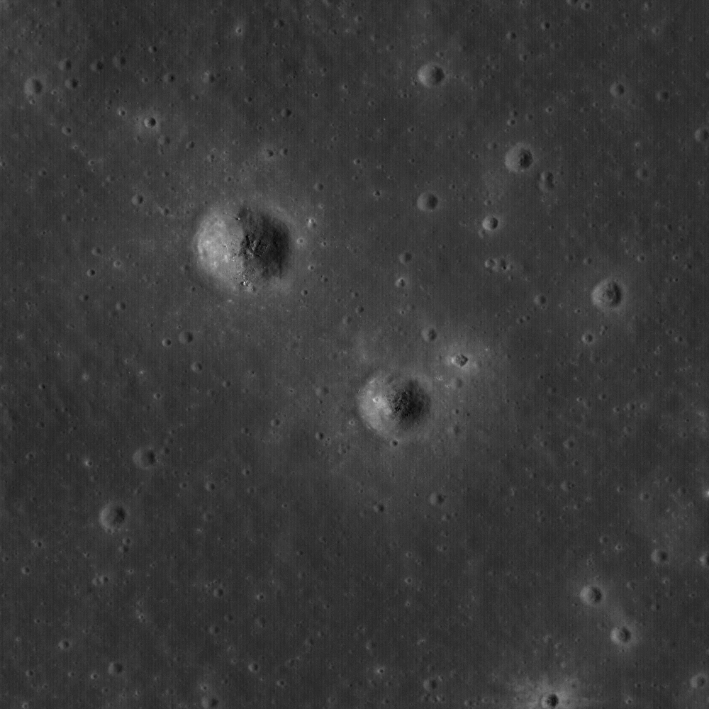
Small dome in the Compton-Belkovich "Thorium Anomaly" region (61.33 °N, 99.68 °E). Evidence indicates a volcanic origin for this and other intriguing features in this relatively small area in the highlands of the lunar farside's northern hemisphere. Solar illumination Incidence Angle is 64°, Sun is from the SSW, field of view roughly 510 meters. LROC Narrow Angle Camera (NAC) observation M139238146L, LRO orbit 5653, September 16, 2010. See the full-size LROC Featured Image HERE [NASA/GSFC/Arizona State University].


Same dome, early evening shadow, brings out small topographic features in relief. Note in the close-up view in the image following below the summit boulder shadows. Full frame field of view above is roughly 3100 meters across; LROC NAC observation M119198897L, LRO orbit 2700, January 27, 2010 [NASA/GSFC/Arizona State University].

Mark Robinson
Principle Investigator
Lunar Reconnaissance Orbiter Camera
Arizona State University

Since the domes in the Compton-Belkovich area are rounded and smooth (excepting the boulders scattered across the summit) they are not easy to spot. At sunrise and sunset (above) even smooth topography casts long shadows. In this case the Sun is 13° degrees above the horizon, showing that the slopes of the dome are steeper than 13°, an important clue to unraveling its origin. Steeper slopes often mean more viscous magma, which in turn points toward more silica rich compositions.
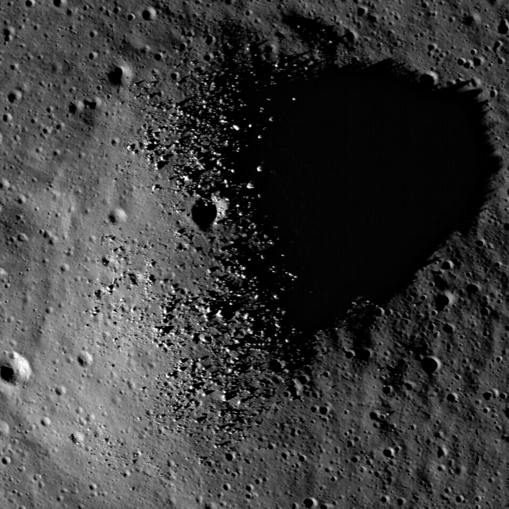

Full-resolution close-up of Compton-Belkovich "Dome-1" from M119198897L and the early evening shadow brings the meter-sized boulders into view [NASA/GSFC/Arizona State University].

Are you having trouble seeing the feature as a dome, that is, with positive relief? Consider the above subsampled images above from M119198897L and the wider view that includes a small crater just east of the dome. The sun is from the left. Sometimes your brain can be fooled - you see what is up as what is down. If you know the Sun direction you can "force" the ups to become downs, and vice versa. And what about the little crater at the top of the dome? Is it a volcanic vent or an impact crater? If you said “impact crater” – you are right! The top of the dome is actually about 100 m south of the small crater. The crater just happens to be near the top of the dome.

LROC Wide Angle Camera (WAC) observation M119212328M, LRO orbit 2702, January 27, 2010, and a rare example of "non-mare" silicic volcanism situated between Compton and Belkovich craters on the lunar farside, the "Compton-Belkovich High-Reflectance Feature." For scale, the small dome (and it's companion crater to the east) are indicated by the yellow arrow [NASA/GSFC/Arizona State University].


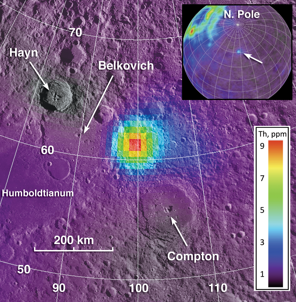
Composite image showing geochemistry from Lunar Prospector and the spike in thorium coincident with the CBHRF. (Note the nearside-farside differences in thorium seen in the inset) View the full-size context composite illustration HERE [Jolliff et al, 2011].

The Compton-Belkovich site was of special interest even before the LRO mission began. Back in 1998 the Lunar Prospector spacecraft, with its gamma-ray spectrometer, measured the global distribution of the element thorium, which has a strong peak in the gamma-ray spectrum because it is naturally radioactive. Although much of the Moon’s thorium, at least as expressed on the surface, lies mostly on the nearside, a terrain between the craters Compton and Belkovich lit up like a bull’s eye (above). For this reason, the site was selected as one of NASA’s Project Constellation sites because it is of high interest for future human or robotic exploration.


Figure 3 from "Non-Mare, Silicic Volcanism on the Moon's Far Side," Jolliff, et al., Lunar & Planetary Science Conference 2011, #2224.

This thorium “hot spot” was described by David Lawrence and the Lunar Prospector gamma-ray spectrometer team (see figure), later Jeff Gillis and coworkers noted in looking at Clementine images that a high albedo feature was located near the center of the thorium bull’s eye (see WAC context image above). However, since then, the origin of the hot spot and the nature of the deposits was not known until LRO imaged the site with the LROC Narrow Angle Cameras. Those images revealed numerous volcanic features, some large, and some small, like the little dome seen in today’s featured image. Between the Lunar Prospector and Diviner geochemistry and the LROC images, we are able to determine that these domes are examples of silicic (rich in silica relative to basalt) volcanism. An amazing discovery - the only silicic volcanism on the farside.

Be sure to return and read future posts about other features in this intriguing and unusual volcanic terrain on the Moon. What a fabulous place this would be for astronaut geologists to explore, do field geology, and collect samples for analysis!

In the meantime explore the full resolution NAC and see what volcanic features you can find!

Friday, June 11, 2010

LROC: The Dewar Geochemical Anomaly


Ejecta from small craters reveal ancient buried mare to the northeast of Dewar crater, near the center of a Constellation region of interest. Image Field of View is 570 meters (Full-sized image, HERE) [NASA/GSFC/Arizona State University].

Samuel Lawrence
LROC News System

This area is the heart of the Dewar geochemical anomaly, one of only a handful of mare deposits on the far side of the Moon. Unlike many mare basalts, such as those that fill Mare Moscoviense, the Dewar deposit is not associated with a giant impact basin, but is instead an ancient and mostly buried mare deposit known as a "cryptomare." Apollo-era imaging of this location was extremely limited; although this region was visible as low-reflectance material in Lunar Orbiter images, the mare deposit was not definitively identified as such until 2008. This discovery came from detailed analysis of multi-spectral images from Clementine (1994) and geochemical information returned by the Lunar Prospector (1998-1999).

Results from these two missions revealed that the low-reflectance materials are spectrally similar to nearside mare basalts, have elevated levels of iron and titanium, and are enriched in the element thorium. So although the Dewar materials are geochemically anomalous in the context of the lunar far side highlands, they are surprisingly similar to nearside basalts.

The small craters that you see in today's Featured Image have excavated material from within the mare deposit. Astronauts visiting craters such as these would be able to unravel clues to the stratigraphy and age of the Dewar basalts.


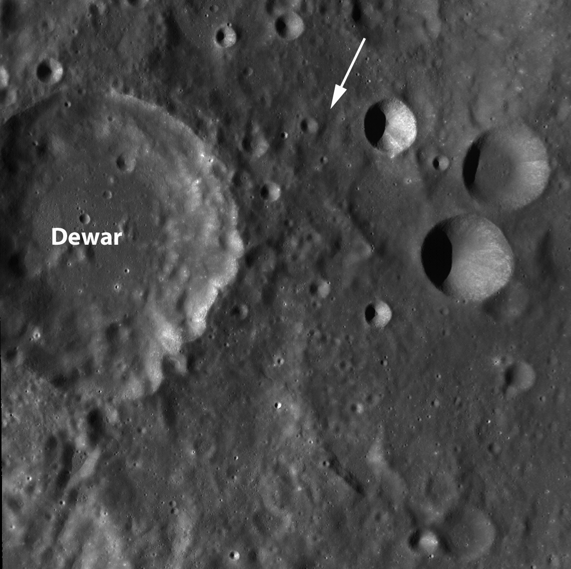
LROC Wide Angle Camera context image (above-lower) of the Constellation Region of Interest northeast of Dewar. Note the low-reflectance deposit visible to the northeast of Dewar crater (apparent also in the close-up of the far lower resolution Clementine albedo image, above-upper. The dotted square on the Clementine image is roughly equivalent to the 90 km-wide field of view in LROC WAC image. The location of the Featured Image is highlighted with a tiny yellow square inside the LROC WAC field of view and the range of the LROC Narrow-Angle Camera image (M128196707L) from which it was taken is designated with the white arrow. [NASA/GSFC/Arizona State University].

Of particular interest is the fact that the Dewar deposits are enriched in thorium. Thorium is an incompatible element, which means that typically it does not get incorporated into magmas until the source is almost completely depleted (or, to put it another way, until there is nothing else left to erupt). Thorium is relatively easy to detect with remote sensing methods because it is radioactive, and when thorium is detected on the surface it is usually safe to assume that other incompatible elements, like the famous lunar KREEP component, are present along with it.


Distribution and abundance of surficial lunar thorium [LPI/Paul D. Spudis, Ph.D.].

These incompatible components are key to understanding the history and mechanics of lunar volcanism and the evolution of the lunar crust. On the near side, many of the mare basalts have high thorium concentrations compared to the typically low concentrations on the far side.

Surprisingly, the thorium abundances in the Dewar region (as well as Mare Moscoviense, which lies to the northwest) are even higher than near side basalts, which has some important implications for lunar geology. Instead of the thorium being concentrated only on the near side, the portions of the far side interior (including the mantle and the lower crust) that produced the magmas emplaced in Dewar and Moscoviense were also rich in thorium. Why are incompatibles concentrated on the near side? What do these small, high-thorium regions on the far side mean? How did the lunar interior evolve to produce this asymmetric distribution of incompatible elements on the Moon? Many important questions remain unanswered.

The geology of this region is complicated and intriguing, and until it is directly explored by astronauts, interpretations based solely on remote sensing data will be challenging. For this reason, this area is a Constellation Region of Interest. The presence of mare basalts also makes this area an in situ resource utilization candidate, since mare materials are so rare on the far side.


Side trips, in the 'Spaceship of the Imagination.' From a point-of-view 3 km over the Dewar ROI, looking toward the south-southwest in the direction indicated by the white arrow in the LROC WAC image further above, the LROC WAC, NAC & Featured Image thumbnail are placed on the Google Earth lunar globe, but perspective and scale are just as difficult to gauge as near the real Moon. On the horizon is the southeastern rim of 50 km-wide Dewar, a point 53 km away from the area within the Featured Image. The elevation there is 2.7 km above global average, towering 3.7 km over Dewar's interior, beyond view. The closest part of Dewar's rim is around 30 km away, with an elevation of 1.4 km; all well over the horizon for anyone standing in the area of the Featured Image, where the elevation at 1.79°S, 166.85°E is about 480 meters [NASA/GSFC/Arizona State University - Google/JAXA].

For more information about the Dewar cryptomare, be sure to check out Planetary Science Research Discoveries.

Plan your own adventure to Dewar crater here!


A second fanciful "side-trip" to that high elevation on the Dewar's rim, 53 km away from the area within the Featured Image. allows an opportunity to see the LROC WAC image super-imposed upon the Google Moon digital elevation model and how closely that image matches an improving but lower-resolution terrain model. The full-sized image made a surprisingly interesting desktop wallpaper [NASA/USGS/JAXA/SELENE/GSFC/Arizona State University].

Friday, February 12, 2010

LROC: Constellation Region of Interest - Crater wall in Van de Graaff


Wall of crater Van de Graaff C
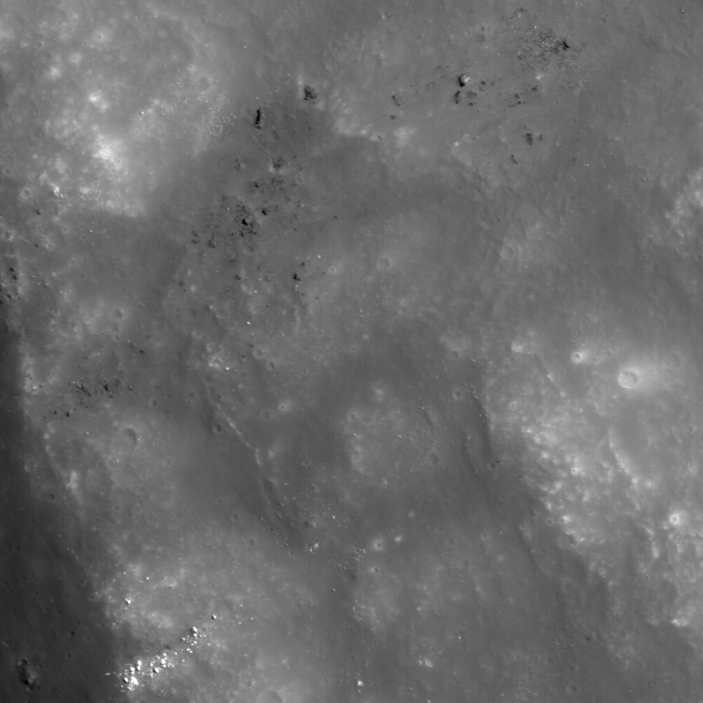
, where brighter material is exposed by more active processes associated with steeper slopes, recent small craters, and even individual rolling boulders. LRO Narrow-Angle Camera image M112822306L, image width 0.68 km [NASA/GSFC/Arizona State University].


Peter Thomas
LROC News System

Wall and rim of a ~20 km diameter crater within the ~240 km diameter Van de Graaff crater, which is one of the Constellation regions of interest. Located on the lunar far side, Van de Graaff crater is south of Aitken crater on the outer edge of the South-Pole Aitken basin. Van de Graaff exhibits an unusual figure-eight shape, ~240 x 140 km, in a region with "swirls", magnetic anomalies, and geochemical anomalies. Swirls on the Moon are high-reflectance, irregularly-shaped markings with gradational boundaries, and they are associated with poorly understood magnetic anomalies (weak by terrestrial magnetism standards).

Magnetic fields like the one near Van de Graaff are relatively unusual for the Moon, because the Moon does not currently have a global magnetic field like the Earth does. Orbital geochemistry measurements show that Van de Graaff and the surrounding terrain have slightly higher concentrations of thorium, which suggests the presence of a geochemically important thorium-rich lunar material called KREEP. Van de Graaff is on the opposite side of the Moon from the massive Imbrium basin, suggesting that perhaps the magnetic and geochemical anomalies are related to the gigantic Imbrium impact event. Or, on the other hand, the anomalies could represent the products of local geologic events. Lunar scientists won't know for sure until we can send human explorers to investigate the region.

Also of particular note in the steep crater walls are higher-reflectance areas. The elevated reflectance is the result of disturbing the regolith (soil) through geologic mechanisms including recent impacts, mass wasting, and by rolling boulders that leave trails. During these events, material from rocks from beneath the surface are exposed. The lunar regolith is typically very fine-grained and is profoundly affected by exposure to the vacuum of space. Over time, radiation and micrometeorite bombardment lower the reflectivity and alter the chemistry of the surface. The high-reflectance, unaltered material exposed at the surface stands out in contrast to the lower-reflectance, older, altered surface.

Explore this fascinating Constellation region of interest for yourself, and check out an Apollo metric orbital photograph of the region!


Apollo 15 Science Mapping camera image 0075 (1971) unveils the north (right) wall of Van De Graaff at sunset, the beginning of the first orbital opportunity. The wispy, relatively bright material on the darkened, optically mature crater floor is associated with one of the Moon's crustal magnetic fields. The same dynamic processes that mature and darken the lunar surface over periods as long as 900 million years, gardening the surface and creating submicron-sized dust, also continuously keep newly exposed, low optically mature material at the surface [Apollo 15/LPI].

Friday, January 8, 2010

Mare Moscoviense Constellation Site


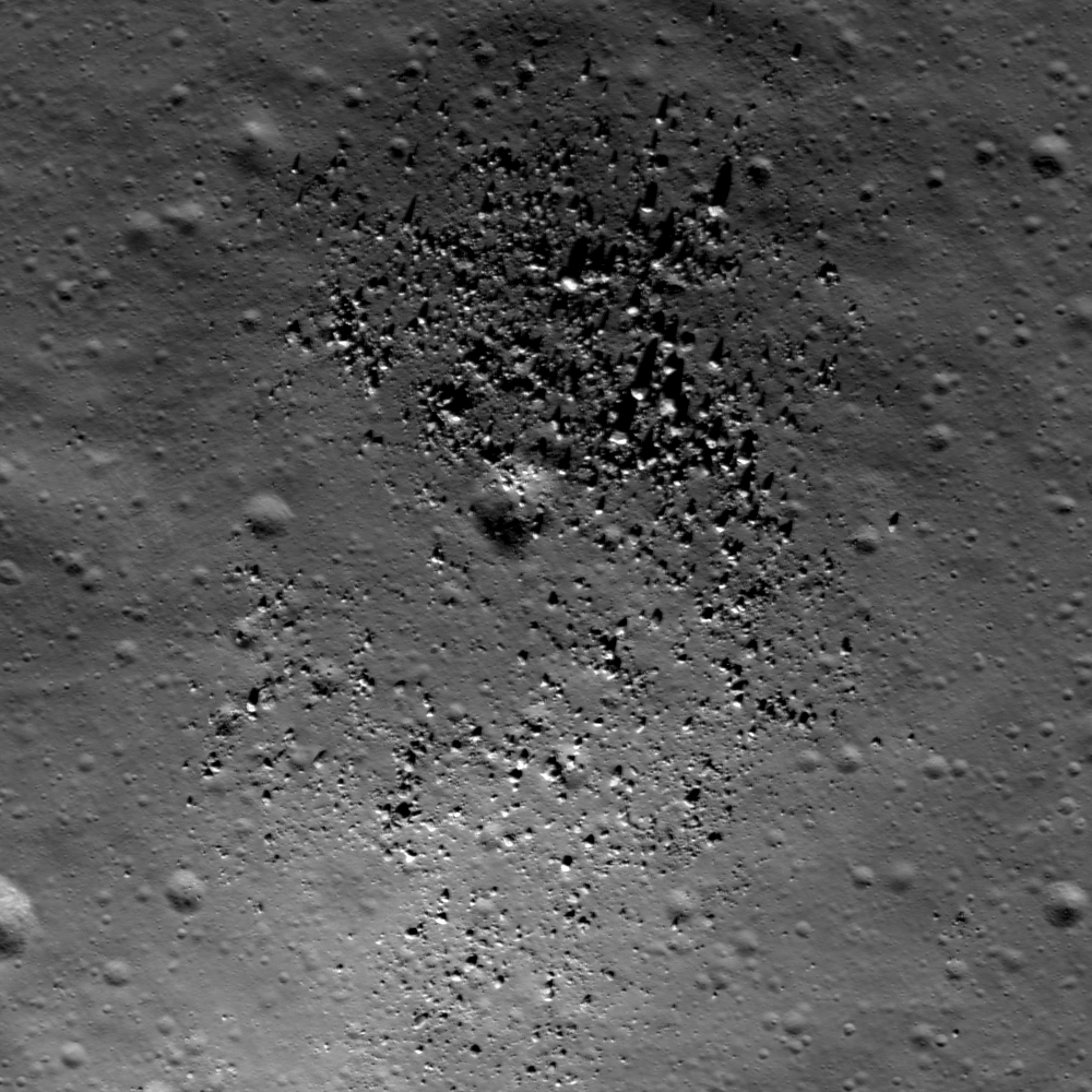
A very subtle mare-highlands boundary in Mare Moscoviense on the lunar farside, near the center of the Constellation Program region of interest. The generalized geologic contact between the mare and the highlands has been highlighted (mare to the left, highlands to the right). Astronauts exploring this region could collect key samples from the farside basalts of Mare Moscoviense as well as materials from the surrounding basin massifs. Image width is 600 meters [NASA/GSFC/Arizona State University].


Samuel Lawrence
LROC News System

The primary mission of the Lunar Reconnaissance Orbiter is to collect the data necessary to enable the human exploration and development of the lunar surface. The instrument suite of the spacecraft, including LROC, was specifically designed with this overarching goal in mind.

Today, the LROC Team begins a new series of Featured Images highlighting the regions of interest for future human lunar exploration that we are imaging for NASA's Constellation Program.

There are fifty of these sites, which were selected prior to LRO launch based on expert input from the lunar science community and NASA engineers. For each of these fifty sites, the LROC Team is collecting a comprehensive set of image data, including observations for geometric and photometric stereo and complete nadir coverage (with repeat imaging at varying illumination). These images, and the associated information products derived from them (such as boulder distribution maps, slope maps, and digital terrain models), will be used by engineers and scientists preparing for the next generation of human lunar exploration. For more information on LROC's observation campaign for the Constellation Program regions of interest read this Lunar and Planetary Science Conference abstract, and visit the LRO Science Targeting Meeting website (look for the baseball card summary sheets for each site: part 1, part 2).

Lunar scientists have been studying the vast data return from the Apollo missions for almost forty years. As a result, much is known about the Moon. For example, we know how to leverage lunar resources to enable future human lunar habitation. Even so, there remains much that we do not know about the Moon. Accordingly, each of these fifty sites is associated with either an immensely compelling lunar science question or an Exploration-enabling resource that will be useful to future explorers, or both. However, these fifty sites aren't intended as actual NASA landing sites, but instead are representative locations whose study will provide mission planners and lunar scientists working on future human lunar exploration with lots of data for a comprehensive suite of interesting and relevant terrains all over the lunar surface. Having said that, each of these locations really would make a great place for the seventh (and the eighth, and ninth, and tenth...) human lunar landing and beyond as we prepare for the long-awaited return of astronauts to the lunar surface. We hope you enjoy these guided tours of some of the most fascinating places on the lunar surface - places where humans should be productively exploring, living, and working in the not-too-distant future.

Mare Moscoviense: Window to Farside Volcanism

It's clear from looking at pictures of the Moon that the nearside and the farside are very different from a geologic standpoint. The low reflectance, basaltic mare deposits dominate the nearside, whereas the bright deposits of anorthosite thought to be remnants of the Moon’s original crust dominate the farside. Mare Moscoviense is one of the few (and also the largest) deposits of mare basalts on the lunar farside.


Figure 1. Clementine 750 nm mosaics showing the lunar nearside and lunar farside, with the location of Mare Moscoviense highlighted [USGS/Arizona State University].


Why are there so many mare basalts on the nearside, but so few on the farside? Lunar scientists simply don't know the answer to that question, although we have some ideas. One idea is that the farside crust is simply thicker than the nearside crust, and the rising bodies of basaltic magma simply solidified before they were able to push through the thicker farside crust. However, we won't know for sure until we can get human explorers to the farside to collect samples, and that's where Moscoviense comes in. We know enough about the Moscoviense region from previous missions that we have a well-defined set of questions we can answer by sending human explorers. For example, the Lunar Prospector mission showed that there are relatively high concentrations of thorium in the Moscoviense basin. Thorium acts as a tracer for the lunar KREEP geochemical component found in abundance on the nearside but not on the farside. Understanding the extent and distribution of thorium in the basin may tell us about the global distribution of the lunar KREEP component and thus the evolution of the lunar mantle. We also know from the Clementine mission that the Moscoviense basalts are both iron and titanium-rich. Since basalts form by partial melting of the lunar mantle, sampling Moscoviense basalts provides lunar scientists with vital insights into how the lunar mantle on the farside differs from the nearside mantle, which in turn would help us to learn why mare basalts are so much rarer on the farside and provide key insights about the formation of all of the terrestrial planets, including Mars and Earth.

For these reasons, a Constellation region of interest is located within Mare Moscoviense. As you can see in Figures 2 and 3, the landing site is at the edge of Moscoviense, allowing would-be explorers to collect samples from both the mare basalts and the surrounding highlands terrain during their traverses. A previous LROC Featured Image also shows the Moscoviense-highlands boundary just a few kilometers south of today's image. The materials at the edge of the basin provide important insights into the formation of the Moscoviense basin itself. By exploring and sampling the Moscoviense region, we would date the basalt flows and definitively determine their composition. This sampling would allow us to determine how Moscoviense basalts differ from the nearside basalts sampled during Apollo. Directly determining the age of Moscoviense basalts with laboratory analysis provides important insights into the history of lunar volcanism by determining where the Moscoviense basalts fit in the Moon's volcanic history.


Figure 2. LROC WAC (Red=689, Green=566, Blue=415 nm) mosaic with the location of the proposed Constellation region of interest indicated with arrow [Arizona State University].


While the scientific goals of exploring the Moscoviense region are certainly important, no less important is access to key lunar resources. The lunar regolith (the broken-up rocks and impact products that make up the first 10 meters or so of the lunar surface) in this region is derived in part from the local titanium-rich Moscoviense basalts. This regolith material could be used for a variety of vital purposes, including the construction of human habitats, radiation shielding, or as feedstock for local resource utilization. Taking a longer view, titanium is an important industrial material on Earth, and it will be very important for indigenous lunar industrial development.


Figure 3: Twenty times downsampled mosaic of LROC NAC images M105887165LE and M105887165RE showing location of the Moscoviense Constellation region of interest; image is 77.6 km tall by 14.5 km wide [Arizona State University].


Explore the Mare Moscoviense Constellation region of interest for yourself, and imagine what it would be like to plant your own boots in the lunar surface!

Explore a previously released NAC image showing another portion of the Moscoviense basin.