Wednesday, April 10, 2013

General Bolden on the Moon

EDITORIAL : The Space Community experienced a minor brush fire late last week, set accidentally perhaps, by NASA administrator Charles Bolden and his reaction to the National Research Council's congressional-commissioned review of NASA’s "strategic vision."

It’s a sad fact of American politics that the release of the NRC report might have passed largely unnoticed had Bolden been as cryptic about the Moon’s place in NASA’s future as the rest of the administration has been from is beginning.

Instead he confirmed for us one line of reasoning into the administration’s actual rationale for erasing the Moon from National Space Policy, three years ago.

“I don’t know how to say it any more plainly,” Bolden said. “NASA does not have a human lunar mission in its portfolio, and we are not planning for one.”

He warned the next administration not to change course “again” back to the Moon. That would mean, he said, the U.S. would “never again see Americans on the Moon, on Mars, near an asteroid, or anywhere. We cannot continue to change the course of human exploration.”

“NASA will not take the lead on a human lunar mission,” Bolden said. “NASA is not going to the Moon with a human as a primary project probably in my lifetime,” because “we can only do so many things, and NASA’s focus will remain on human missions to asteroids and Mars.”

“All that was 'a given,' three years ago,” Apollo 17 commander Gene Cernan said afterward on Tuesday, perhaps forgetting along with General Bolden, that "going to the Moon as a primary project" has not been a goal of the American government since 1969, and this was never "a primary project" of the Vision for Space Exploration in 2004 or of those who recognize the Moon's strategic and scientific value and who still support restoring the Moon back into scientific context today.

On the surface there did seem little that was new in Bolden’s protests. All the superficial reasons for dropping the Moon as an intermediate objective on the way to Mars spread abroad by the administration and its supporters still make little sense. No one who seriously supported a return to the Moon as an essential objective on the way to Mars ever hoped simply to recreate Apollo. 

And if it’s asteroids you want, the Moon has been an asteroid magnet for about 4.575 billion years.

Aside from the glaring hole left by having had the Moon erased from National Space Policy, three years after the cancellation of Constellation, America's deep space efforts are really little different from what they were at the end of the Bush administration, with little actual progress having been made not already set in motion before President Obama's Inauguration.. 

Aside from the missing Altair lander, and the R&D required to build it, together with a simple recognition of the Moon’s clear strategic value in overcoming tremendous technological challenges facing any manned mission to Mars, very little has actually changed.

The end goal of landing astronauts on Mars, someday, some way, in budgetary “out years,” is still the same, as was retiring the Space Shuttle and planned development and use of commercial transportation to ISS. These were integral to the Vision for Space Exploration introduced in 2004. Though some seem determined to credit the administration with having dreamed up subsidized commercial space, and certainly for popularizing the idea, that too was integral to the VSE and as far as presidents go the initiative dates back to Ronald Reagan.

From a political perspective, with unwitting help from General Bolden, we no longer have to simply make educated guessed as to why the Moon was edited out of NASA’s strategy. As it turns out, it was not the “been there, done that” argument offered by the President, after all..

Bolden has finally confirmed for us one line of investigation into the mysterious missing Moon by simply telling us that the Obama administration just does not want the American governmentto take the leadon any manned return to the Moon.

Thus, it was a political decision, dressed up and oversold with some of the tired arguments originally heard forty years ago.

That's not a crime, of course. Thankfully Bolden has also communicated that the administration is not opposed to "leading from behind" on a manned mission to the Moon, perhaps lead by a different nation, nor does he rule out robotic exploration, though the nation has so far committed only to finishing or fulfilling the precursor robotic lunar missions that were either already underway or already long in the pipeline.

We are genuinely grateful the administration appears unwilling to stand in the way of any commercial manned or unmanned landings in the Moon.

But why this passionate and now very specfic opposition to America leading while exploring and using the Moon as a stepping stone to Mars and as a Rosetta Stone for the rest of the Solar System?

In light of all the other alterations made to the President's 'asteroid initiative' over the past three years, was the administration's unyielding position the original and still primary reason the whole Constellation program was cancelled?

The Moon, and those of us still urging policy makers to take another look at its advantages over manned asteroids exploration, are apparently occasionally being heard in the White House. In the past three years the administration has occasionally floated tantalizing trial balloons, future efforts involving the Moon, but specifically without any  human landing.

One thing is different in the past three years. The small flotilla of remote sensing spacecraft, from Japan, China and India, as well as the U.S. sent to the Moon, and inspired by the lead America had taken with in 2004, after a long national drought five American spacecraft in lunar orbit simultaneously for most of this past year, and planetary scientists have learned more about the Moon since 2004 than in the two decades previous.

This new look at the Moon has by now strongly confirmed the Moon's strategic importance and its usefulness to science, and as a logical support for future manned missions to Mars.
"Just after it has been relegated to a “been there, done that” status, the Moon again shows us we have a lot to learn about its history, physical state and the potential value of its resources. We must take the initiative to learn more as the Moon is crucial in developing and advancing a sustainable space faring infrastructure." -   Paul D. Spudis

Why then, like Arthur C. Clarke’s Europa, are American astronauts to “attempt no landing there?” If we are taking the lead going to Mars, our role in a return to the Moon along that path would seem to be irrelevant.

This much is clear. Leaving the Moon out as an intermediate goal, as a place where America already has a momentary and essential lead, is a stubbornly held position dear to the administration.From Bolden’s statements late last week one might think someone had suggested NASA’s strategy for building a path to Mars should be renamed back to “Constellation.”

Though only occasionally experienced, if America’s history and the nation's storied history of manned space exploration has succeeded in teaching us anything it has taught history has a very tight turning radius.

John Moore's "Watered Moon"


John Moore has a new video quite different than what we've posted of his work previously. About the video above he recommends:
"Several theories abound as to the Moon's formation. One in particular is 'The Giant Impact Theory', which suggests a Mars-sized object struck our proto-Earth, and ejected vast amounts of material that later accreted to form the Moon. The two worlds developed quite differently over time -- one sustaining [life as we know it], the other a barren landscape completely indifferent to our natural needs. Central to formation of life on Earth was water, which fueled the diversity of life at every level. For the Moon, however, it wasn't to be so. But what if the conditions were just right, and water could sustain on the lunar surface, what then would have been the outcome? Let's see..."
Without unnecessary delay, we'll include the following additional work by John, though it deserves its own post with explanatory illustrations. It deserves its own Poster. As it is, we include links to earlier related posts since these two extremities of lunar elevation, first identified by Japan's Kaguya investigators and refined by American teams using data from LRO, have been of particular interest here.


Related Posts:
Oblique views of the Moon's highest and lowest places (October 3, 2012)
View from Vavilov (January 31, 2012)
DLR: Flying over the three-dimensional Moon (December 1, 2011)
LROC's new Global Lunar Topography (November 16, 2011)
LOLA's deep Antoniadi (April 16, 2011)
LRO's unprecedented topography of the Moon (December 17, 2010)
Highest point on the Moon (October 26, 2010)
The deepest spot on the Moon nearly wasn't (September 17, 2010)
Lunar superlatives from LROC WAC (September 6, 2010)
The Moon's lowest of the  low (November 24, 2009)
Accurate topographic map of the Moon (June 13, 2009)
Spectacular refinements to Kaguya laser altimetry (May 28, 2009)
Best lunar topography derived from Kaguya (February 12, 2009)

Monday, April 8, 2013

The Mystery of Shackleton Crater

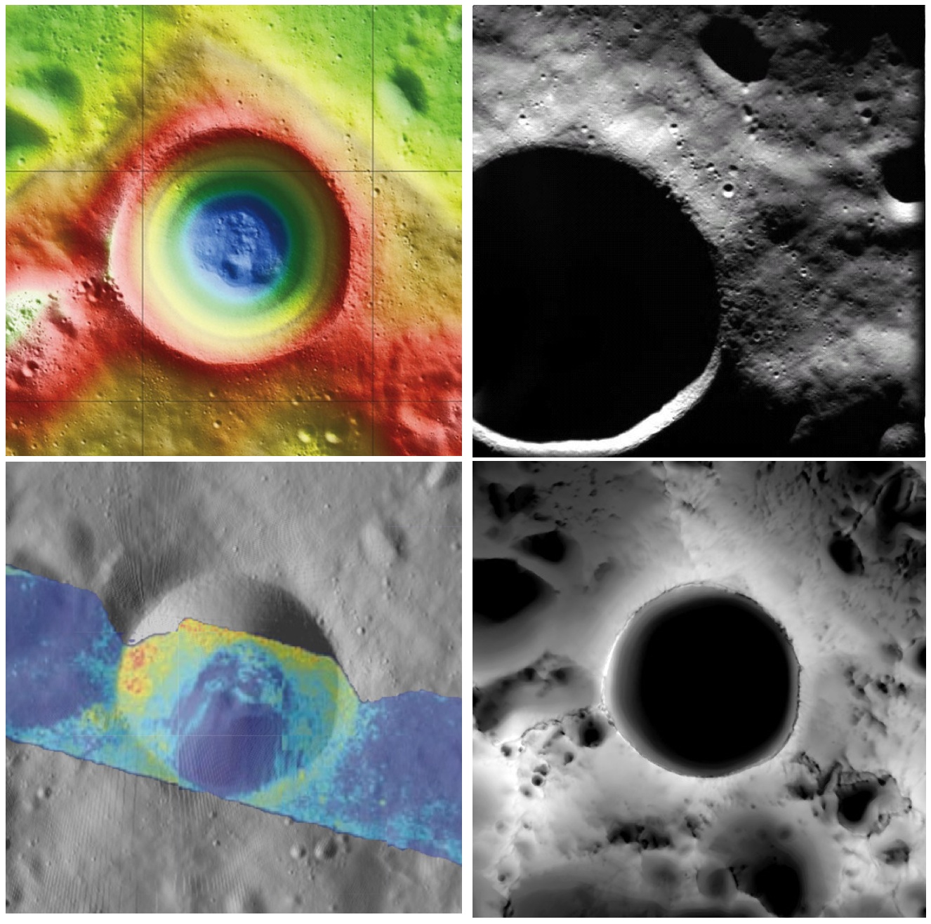
Shackleton crater, Earth's Moon. Clockwise from top left: topography from (LOLA) laser altimetry, photography from ESA SMART-1 mission, lighting map (relative isolation - brighter indicates longer periods of illumination) from LROC data, Mini-RF Circular Polarization Ratio (CPR) image draped over shaded relief. The crater is about 20 km across.
Paul D. Spudis
The Once and Future Moon
Smithsonian Air & Space


Though unremarkable in appearance compared to the roughly 4,000 craters on the Moon in its size range, the 20 km diameter crater Shackleton has been the source of relentless scientific controversy for the past 20 years.  Shackleton is located at the south pole of the Moon; indeed, its near side rim is the precise location of the geographic pole itself.   Its location makes observation by Earth-based telescopes difficult and it was not well photographed by the Lunar Orbiter series (our principal source of lunar images) of the 1960s.  That all changed in 1994 with the flight of the joint DoD-NASA mission to the Moon, Clementine.

Clementine carried cameras that globally imaged the Moon in eleven visible and near-infrared wavelengths.  In addition, it mapped the surface and lighting of the poles of the Moon at uniform resolution over the course of almost three lunar days (74 Earth days).  When the Science Team first saw the south polar mosaic, the extent of darkness in the map was striking.  Because the Moon’s spin axis is close to perpendicular to the ecliptic plane, the Sun is always at the horizon at the lunar poles.  Instead of rising and setting, the Sun circles around the poles at or near the horizon.  Because of this grazing incidence, an area in a topographic depression may be in permanent shadow.  And so it appeared for Shackleton crater in the Clementine data, setting off bells in the heads of the Science Team.

Intuitive selection from HDTV still frame captured by Japan's lunar orbiter SELENE-1 (Kaguya) in 2008 shows Shackleton, with the Moon's south pole on its rim (upper left) in relation to Earth and Malapert Massif, part of the nearside rim of the ancient South Pole-Aitken impact basin, along the line of sight. Shackleton's interior and the craters between it and Malapert, are permanently shadowed interiors (PSR), unmapped before the 21st century [JAXA/NHK/SELENE].
A key controversy of the post-Apollo era was whether the lunar poles might contain water or not.  Although the Apollo samples had been studied and found to be “bone-dry,” we had not been to the poles on any Apollo mission.  We knew that any shadowed areas had to be extremely cold as well as permanently dark.  As water-bearing debris in the form of asteroids and comets constantly strike the Moon, it was thought that some of that water might get into a polar “cold trap” and would be kept there (essentially) forever – billions of years of impacting cosmic “debris” can add up.

Clementine was not configured to measure the presence of water, but a cleverly improvised experiment used the spacecraft’s data transmitter to beam radio waves into the dark regions near the poles and listen to their reflected echoes on the enormous (70 m) dish antenna of NASA’s Deep Space Network.  Interestingly, the reflections indicated an enhancement of “same sense” polarization within the (very large) resolution cell that contained Shackleton crater.  A collect of data from a nearby sunlit area (taken as an experimental control) did not show this peak.  The Clementine team interpreted the RF peak as evidence for the presence of a few percent water ice within the dark, cold interior of Shackleton crater.  The media quickly spread the startling news about water on our “bone-dry” Moon.

Shackleton, as seen in a joint 70 mm radar experiment collected by radio telescopes at Greenbank and Arecebo during a favorable libration opportunity in 2006.
Such a controversial conclusion did not go unchallenged.  Some in the radar community argued that abundant wavelength-sized rocks on the surface were the source of the enhanced same sense reflection.  Since the lunar surface is indeed rocky, this interpretation could not be ruled out.

Then a few years later, the Lunar Prospector (LP) mission found an enhancement of hydrogen concentration at both poles of the Moon; as hydrogen is a major constituent of water, the idea ice exists in the dark areas gained credence and has lead to a decade-long scientific search (using a variety of techniques) for lunar polar ice.  Though many areas near the poles were studied in detail, attention continued to be drawn back to Shackleton and the area near the south pole.

From studying Clementine images, we discovered that part of the rim crest of Shackleton is one of the most sunlit areas on the Moon.  Now we had a double-attraction: constant sunlight with water ice nearby.  At a press briefing in 1996, I called this area of water and sunlight “the most valuable piece of real estate in the Solar System.” Nothing found subsequently has changed my mind on that judgment.

So what have we learned about Shackleton lately?  Many different, new sensors have flown to the Moon in the last few years, including radar, ultraviolet (UV) imaging, laser reflections, and low-light level imaging.  And yet again, Shackleton crater continues to confound us with contradictory evidence, both for and against the presence of water ice in its interior.

In 2009, the question regarding the presence of water ice somewhere near the lunar south pole was answered when the LCROSS impactor threw up a cloud of water vapor and ice particles during its collision with the floor of the nearby crater Cabaeus.  Spectral mapping instruments on three different spacecraft (Chandrayaan-1, Cassini, and EPOXI) documented the presence of adsorbed water on the lunar surface, increasing in concentration with latitude toward both poles.  A small impact probe flown by India (MIP) passed through a water vapor zone in the exosphere just above the lunar south pole.  And radar images from Mini-RF, our radar imaging experiment on both Chandrayaan-1 and Lunar Reconnaissance Orbiter (LRO), found evidence of high same sense reflections (just as Clementine had suggested in 1994) within the interior of Shackleton crater.
LRO Mini-RF instrument radar data indicate the walls of Shackleton crater may, indeed, hold ice, confirming exacting measurements of laser altimeter (LOLA) point brightness studies revealed in June. Actual observations (CPR) are compared to calculated radar values for 0.5% to 10% ice. Illustration to post "Mini-RF adds to evidence of ice on Shackleton walls," September 1, 2012 [NASA ].
These new lines of supporting evidence were countered by Japanese researchers, whose Kaguya spacecraft imaged the interior of the crater and found morphology similar to other lunar craters in the same size-class.  But no one had ever claimed that the interior of Shackleton was a skating rink of pure ice – the lunar polar ice is partly covered by waterless dust and mixed with an unknown amount of dry regolith.

Interpretation of the new data continues to vex us.  The LOLA (laser altimeter) team on LRO recently published a paper that documents the high reflectivity (at 1 micron wavelength) of the walls of Shackleton.  Although the team’s favored interpretation is that this is caused by a constant exposure of fresh material on a steep slope, they also note that it is consistent with the presence of water ice on the walls of the crater.

In addition, a team analyzing neutron spectrometer data from both LP and LRO found evidence in the fast neutron data (never before analyzed) that water in the interior of Shackleton is a possible explanation for its signal.  Detailed analysis of the Mini-RF data for Shackleton corrected for its steep wall slopes and found that the presence of 5-10 wt.% water there provides the best model fit to the observed data.  Newly obtained UV images from LRO show the existence of water frost in the interiors of the craters Haworth and Shackleton, and the neutron detector on LRO shows enhanced hydrogen within both Shoemaker and Shackleton craters.  The Japanese team from Kaguya continue to insist that the no-ice interpretation is the correct one.

So we are left with a mystery.  Some evidence is pro-ice and some is contra-ice.  I find it interesting that for most of the investigators, new data does not necessarily change any minds, but tends to be interpreted in a way most favorable to their previously published ideas.  This should not be terribly surprising; the people who have argued for some specific interpretation presumably did so for good reasons and desire hard and clear-cut evidence to the contrary before abandoning a previously held position, one no doubt reached after much thought and soul-searching.

Less so, but still-mysterious Shackleton, "twice as deep as the Grand Canyon," from "Tour of the Moon," a 2:30 video prepared by the Science Visualization Studio (SVS) at Goddard Space Flight Center in 2012 [NASA/GSFC/SVS].
The way to unravel the water-ice mystery is to go to the surface of the lunar south pole (or both poles) and measure the composition of the surfaces in question.  Getting a definitive answer about the nature of lunar water would be game changing.   Some say the bigger mystery is:  Why hasn’t the United States sent a rover to the south pole of the Moon to take a closer look?

Originally published April 8, 2013 at his Smithsonian Air & Space blog The Once and Future Moon, Dr. Spudis is a senior staff scientist at the Lunar and Planetary Institute. The opinions expressed are those of the author but are better informed than average.

Related Posts:
Mini-RF adds to evidence of ice on Shackleton walls (September 1, 2012)
Shackleton harbors ice after all (June 12, 2012)
1000 Day Anniversary of LROC Imaging (March 27, 2012)
Shackleton on a Summer's Day (March 26, 2012)
Shadowed fluffy lunar frost detected in starlight (January 14, 2012)
Shackleton: Out of the Shadows (September 17, 2009)

Saturday, April 6, 2013

Do large impacts always erase surface mineralogy?

Our present all-encompassing view of the nearside landmark lunar crater Copernicus seems only a little different than the best photography from Earth. Only 20 degrees west and less than 10 degrees north of the 'center' of the Moon's tidally-locked hemisphere, the round rim appears only slightly oblong from angle seen from our backyards. Its general brightness, both inside and out, wash out much of the detail seen in this LROC Wide Angle Camera (WAC) monochrome (649 nm) montage made up of observations in six orbital passes in January 2010. Long recognized differences can easily be confirmed between the northwest quadrant and the remaining three-quarters of the crater floor may be more extraordinary than previously believed possible [NASA/GSFC/Arizona State University].
EDITORIAL NOTE: One of a handful of features on the Moon's nearside detectible to the naked eye, it's amazing what there is still to be learned about the majestic crater Copernicus. Not as young and bright as Tycho, with rays streaming over an entire hemisphere, it's rays are impressive enough and the larger Copernicus is distinctive enough be the namesake for an entire lunar Age, the "Copernican," the Moon's most modern period, encompassing features less than about 1.1 billion years old.

This has made the Copernican family of excavations very valuable to planetary scientists who utilize Earth's Moon as the Rosetta Stone of the Solar System (and, increasingly, our Earth - the planet with which it has shared precisely the same space in the universe for approximately 4.575 billion years.

Most likely mapped first by Galileo, the 93 kilometer impact crater has since his time been drawn and redrawn with with increasing precision and appreciation. Since the 19th century, and definitely since the latter half of the 20th century, Copernicus may be the lunar crater most individually photographed from Earth. A highly oblique orbital image captured from Lunar Orbiter 2, November 24, 1966, is one of only a handful of images popularly celebrated as a "Photograph of the Century." 

Detail (highly resampled) from Lunar Orbiter 2-162, oblique view from 26 km over the lunar surface south of Copernicus crater, November 24, 1966 [Moonviews].
That delicate telemetry was recovered and reprocessed by the phenomenal Lunar Orbiter Image Recovery Project (LOIRP) in 2009. Without question, we have learned a great deal about the Moon since 1957, but, until recently, not very much more about Copernicus crater than might have been inferred using a decent telescope here on Earth. It's complexity and subtle albedo has defied definitive understanding.

We have known for some, for example, it has at least two (or three) central peaks, and mulled over tantalizing indications of a twin set of widespread rays - hinting at a near simultaneous double impact. High-resolution analysis of its wide interior achieved greatest progress in study of the continued arrival of unambiguously remote sensing from India's Chandrayaan-1 and the U.S. Lunar Reconnaissance Orbiter (LRO) after beginning its on-going mission in close polar orbit in 2009. 

Hints that the northwest quadrant of its interior floor is very distinct from the remaining three-fourths slowly have finally come into focus, hopefully to stay.

The demarcation between the character of the western and eastern north floor of Copernicus has just become more obvious as images from LRO continued to improve. Those differences are particularly striking in spectral analysis, by the Clementine orbiter in 1994, for example. LROC WAC observation M147109260CE (643 nm), spacecraft orbit 6813, December 16, 2010; angle of incidence 77.97° at 60 meters per pixel resolution, from 43.13 km [NASA/GSFC/Arizona State University].
Now the distinguished lunar and planetary scientist Carle Pieters and a team at Brown University have added another set of clues to sharp lines from remote sensing of the northwest quarter of the floor of Copernicus that might have everyone refining or completely revising set theories about what happens in those fantastic and brief hours immediately following a highly energetic crater-forming impact.

Pre-existing mineral deposits on the Moon (sinuous melt, above) have survived impacts powerful enough to melt rock. Not detectable in the crater image (inset), deposits are visible only in light at certain wavelengths [NASA/Deepak Dhingra].
Brown University — April 2 — Despite the unimaginable energy produced during large impacts on the Moon, those impacts may not wipe the mineralogical slate clean, according to new research led by Brown University geoscientists.

The researchers have discovered a rock body with a distinct mineralogy snaking for (28.9 km) across the floor of Copernicus crater, a 60-mile-wide hole on the Moon’s near side. The sinuous feature appears to bear the mineralogical signature of rocks that were present before the impact that made the crater.

The deposit is interesting because it is part of a sheet of impact melt, the cooled remains of rocks melted during an impact. Geologists had long assumed that melt deposits would retain little pre-impact mineralogical diversity.

Large impacts produce giant cauldrons of impact melt that eventually cool and reform into solid rock. The assumption was that the impact energy would stir that cauldron thoroughly during the liquid phase, mixing all the rock types together into an indistinguishable mass. Identifying any pre-impact mineral variation would be a bit like dumping four-course meal into a blender and then trying to pick out the potatoes.

But this distinct feature found at Copernicus suggests that pre-existing mineralogy isn’t always blended away by the impact process.

“The takeaway here is that impact melt deposits aren’t bland,” said Deepak Dhingra, a Brown graduate student who led the research. “The implication is that we don’t understand the impact cratering process quite as well as we thought.”

Close up view of the feature marked with light green, designated "Surrounding Melt (Fe-Ca rich Pyroxene)" in the study illustration immediately above. LROC Narrow Angle Camera (NAC) observation M175408129R, spacecraft orbit 10984, November 8, 2011; resolution 41 cm per pixel from 26.06 kilometers [NASA/GSFC/Arizona State University].
The findings are published in online early view in the journal Geophysical Research Letters .

Copernicus is one of the best-studied craters on the Moon, yet this deposit went unnoticed for decades. It was imaging in 83 wavelengths of light in the visible and near-infrared region by the Moon Mineralogy Mapper — M3 — that made the deposit stand out like a sore thumb.

M3 orbited the Moon for 10 months during 2008-09 aboard India’s Chandrayaan-1 spacecraft and mapped nearly the whole lunar surface. Different minerals reflect light in different wavelengths at variable intensities. So by looking at the variation at those wavelengths, it’s possible to identify minerals.

In the M3 imaging of Copernicus, the new feature appeared as an area that reflects less light at wavelengths around 900 and 2,000 nanometers, an indicator of minerals rich in magnesium pyroxenes. In the rest of the crater floor, there was a dominant dip beyond 950 nm and 2400 nm, indicating minerals rich in iron and calcium pyroxenes. “That means there are at least two different mineral compositions within the impact melt, something previously not known for impact melt on the Moon,” Dhingra said.

It is not clear exactly how or why this feature formed the way it did, the researchers say. That’s an area for future study. But the fact that impact melt isn’t always homogenous changes the way geologists look at lunar impact craters.

“These features have preserved signatures of the original target material, providing ‘pointers’ that lead back to the source region inside the crater,” said James W. Head III, the Scherck Distinguished Professor of Geological Sciences and one of the authors of the study. “Deepak’s findings have provided new insight into the fundamentals of how the cratering process works. These results will now permit a more rigorous reconstruction of the cratering process to be undertaken.”

Carle Pieters, a professor of geological sciences at Brown and the principal investigator of the M3 experiment, was one of the co-authors on the paper, with Peter Isaacson of the University of Hawaii.

Thursday, April 4, 2013

Downhill creep or flow on the floor of Vitello?

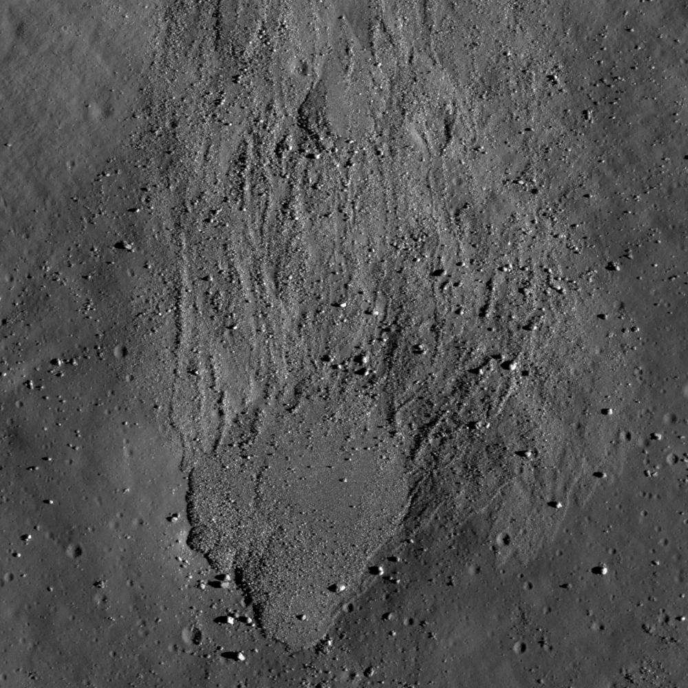
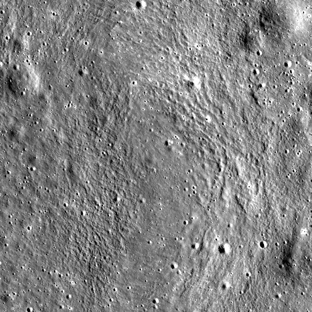
Southern slope of a fracture developed in the floor of Vitello crater, on the south side of Mare Humorum. Downward slope is toward upper left in a 640 meter wide field of view centered on 30.214°S, 322.352°E, LROC NAC M1101460425L, LRO orbit 14652, September 5, 2012; angle of incidence 31.65° over 0.64 meters resolution, from 61.86 km  [NASA/GSFC/Arizona State University].
Hiroyuki Sato
LROC News System

Vitello crater is a floor-fractured crater (42.5 km in diameter), located at the south edge of Mare Humorum.

As seen in the LROC Wide Angle Camera (WAC) context view further down, there is a circular network of fractures, with numerous branches, throughout the crater floor.

The opening images (above and immediately below) highlights a portion of north facing slopes inside one of these fractures (yellow box and arrow).

Full with of LROC NAC M1101460425L, from the corrected exploration link at the bottom of this post. The yellow square encompasses the area within the LROC Featured Image, released April 4, 2013 [NASA/GSFC/Arizona State University].
The dark materials on the floor of the crater partially cover the upper part of this fracture. The dark materials extend from the bottom right to upper left and are detoured around of a large boulder (30 by 20 meters) at the center of opening image, indicating that these materials flowed down the slope. With occasional events of slope failures or meteorite impacts, they might have flowed at once or little by little over a long period of time. But of what is this dark material composed?

The origin of floor-fractured craters on the Moon is still under discussion, but volcanic intrusions are suspected, and some of the fractures are associated with Dark Mantle Deposits (DMD), that are likely pyroclastic in origin. In Vitello crater, no clear DMD have been documented. But since the circular cracks are well developed in this crater, pyroclastics or any low reflectance materials of volcanic origin might have covered the fractured floor surface, supplying the dark materials flowing into the open cracks as seen in the opening image. 

Vitello crater and surrounding areas in LROC WAC monochrome (604nm) mosaic (70 meters per pixel) centered on 30.393°S, 322.43°E, stitched from three LROC WAC observations, from three sequential orbital passes, February 6, 2010, from just above 50 km altitude. The locations of area  in the LROC Featured Image (yellow arrow) is indicated once again [NASA/GSFC/Arizona State University].
Explore the slopes of the floor-fractured crater on the Moon in full NAC frame yourself, HERE.

Related Posts:
Rimae Posidonius
DMD Excavations
Pyroclastics and Vent
Pyroclastic Excavation
Pattern of dark deposits
Alphonsus crater mantled floor fracture
Low Reflectance Deposits on the Lassell Massif

Beautiful ejecta patterns from a very young crater

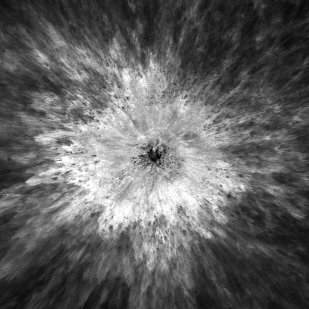
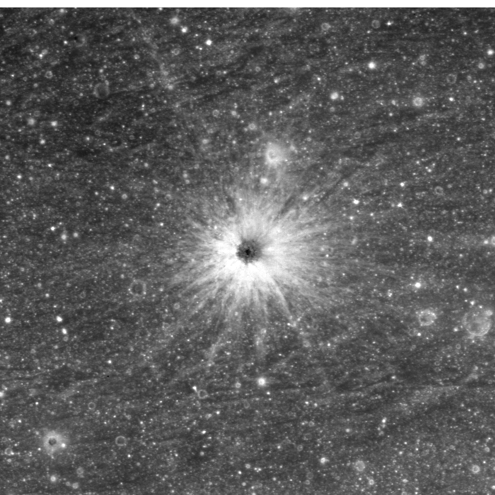
Unnamed, very fresh crater on the north side of Mare Fecunditatis, near 3.637°N, 48.93°E and a field of view about 1400 meters across; under a high Sun (illumination incidence angle 13.5° - LROC Narrow Angle Camera (NAC) M187921190LR, LRO orbit 12758, April 1, 2012; native resolution 0.93 meters per pixel from 108.16 kilometers [NASA/GSFC/Arizona State University].
Hiroyuki Sato
LROC News System

Today's Featured Image highlights an unnamed small crater (roughly 180 meters in diameter) at the northern edge of Mare Fecunditatis, near the Catena Taruntis.

The strong reflectance contrast between the ejecta deposit and the surrounding background in the opening image suggests that this crater is still very flesh and young.

The low reflectance materials in the center of this crater are probably impact melts or a different rock type in the subsurface that was excavated by the impact. The numerous dark dots intermixed with the high reflectance ejecta might be same dark materials as the one on the crater floor, or more likely secondary craters excavating the background mature material.

A step backward to reveal a roughly 4 km field of view from the same mosaic of the left and right frames of LROC NAC observation M187921190, showing the delicate widespread bright field of rough ejecta - against the very optically mature surface of Fecunditatis
This beautiful ejecta field consists of numerous lobes systematically piled on the top of adjacent outer lobes, resulting in a view like a stop motion picture of the impact event. Apparently, ejecta that landed far away from the impact center settled on the ground earlier than the portion that traveled a shorter distance. High resolution images of these very fresh craters supply key information about impact cratering, which improves our knowledge of the craters and helps to reveal the history of any airless planetary bodies in our solar system. 

Footprint of LROC NAC M187821190L (on the right) and R (on the left). An LROC Wide Angle Camera montage assembled using the new LROC Lunaserv online application [NASA/GSFC/Arizona State University].
Explore this beautiful fresh crater on Mare Fecunditatis in full NAC frame yourself, HERE.

Tuesday, April 2, 2013

Melt or Rubble in Carrel Crater?

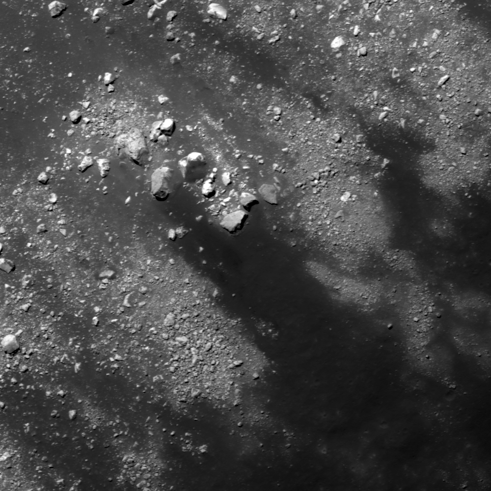
Debris pile at the bottom of north wall of Carrel crater (downslope toward bottom). Image center near 10.846°N, 26.653°E, field of view 500 meters, incidence angle is about 69° LROC Narrow Angle Camera (NAC) observation M177460712L, spacecraft orbit 11288, December 2, 2011; native resolution 47 cm per pixel from 38.78 km [NASA/GSFC/Arizona State University].
Hiroyuki Sato
LROC News System

Carrel crater (15.6 km in diameter) is located near the center of Mare Tranquillitatis.

On the north wall of this crater you can find several eye-catching flow features, starting from near the top of the wall, merged together on the way down to the bottom and finally deposited in a local topographic depression.

 The opening image highlights the infilled depression.

Is this fill composed of solidified impact melt, or simply a granular flow that originated by a slope failure? Which do you think?

The 4640 meter full width of the left and right frames of LROC NAC M177460712, from the newly-revised LROC QuickMap, zeroed in on Carrel crater. The feature highlighted in above and another, similar phenomena are designated with arrows [NASA/GSFC/Arizona State University].
The large incidence angle (69°, measured from vertical) of this image shows distinct relief of these flow features. The materials dumped in the depression show a flat surface where half is covered by gravel or rubble. The shadows along the left edge of this deposit give depth and imply a certain thickness, and no cracks or ridges are recognizable on the deposit surface. Typically impact melt flows exhibit viscous flow features (e.g. round distal edges, pressure ridges and levees as seen in Necho Crater, Channels And Fractures, Lichtenberg B Flow) and surface cracks. Not all these features are found in today's Featured Image.

Carrel crater and vicinity in LROC Wide Angle Camera (WAC) monochrome mosaic (100 m/pix), centered near 10.65°N, 26.71°E. The locations of full NAC frame (blue box) and the featured highlighted in the LROC Featured Image, released April 2, 2013 (yellow arrow) are shown [NASA/GSFC/Arizona State University].
Granular flows normally spread out in the final deposit, making thin distal edges as seen in Detour!, Debris Flows in Kepler Crater, Pytheas. But like these examples (Granular Flow, Outside of Giordano Bruno, How Recent?), sometimes they form thick round shapes or have levees along the flow path.

Carrel, a landmark crater of a First Quarter Moon, almost exactly between the landing site of Apollo 11, northwest of Moltke at bottom center and Apollo 17 in Taurus Littrow valley, just west of top center. Astronominsk April 21, 2010.
Those are rather similar to the features observed in the opening image, implying that these flows and the deposit might be formed by granular flows, but it is not easy to conclude due to its enigmatic shape. 

Explore these beautiful and enigmatic flow features in full NAC frame yourself, HERE.

Related Posts:
Debris Flows in Kepler Crater
How Recent?
Meandering
Pytheas
Detour!
Outside of Giordano Bruno
Dichotomy
Dry debris or liquid flow?
Granular Flow
Rock avalanche in Robinson crater

Apollo Command Module ephemeris

Google Earth lunar Digital Elevation Model (DEM) assembled from Apollo J mission (15, 16 and 17) metric orbital photography. The recovered J mission Command Module ephemeris is now posted on the Apollo Scan Project webpage at Arizona State University. The J mission orbital mapping cameras were confined to equatorial latitudes. The belt confined over the south on the nearside was represents photography from Apollo 16, in service to its landing site near the Descartes formation in the southern highlands.
Mark Robinson
Arizona State University

The Apollo Command Module ephemeris were originally recorded to paper, and then later transferred to microfilm. The National Space Science Data Center (NSSDC) scanned the microfilm records containing the state vector data and these files were received by Arizona State University (ASU). 

An in-house custom Optical Character Recognition (OCR) algorithm converted the raster images of the microfilm scans to text format. Manual methods were implemented to read and record values that failed OCR conversion. The final values of the OCR conversion, manual efforts, and subsequent validation are stored in spreadsheets and converted to the NASA SPICE kernel format. Please note that the newly posted data are "first-run" files, and new improved versions will likely be uploaded in the future.

Monday, April 1, 2013

Unassuming volcanic vent north of Aristarchus Plateau

This unassuming textured surface surrounding a smooth tongue of material is likely a volcanic vent. Field of view 1500 meters, from LROC Narrow Angle Camera (NAC) observation M181495512L, spacecraft orbit 11859, January 18, 2011; angle of incidence 66.53° and 1.46 meters resolution from 147.24 km altitude [NASA/GSFC/Arizona State University].
Drew Enns
LROC News System

Igneous rocks are common on the Moon, basalt makes up the darker mare, and anorthosite makes up the lighter highlands. Less common are the volcanic structures that might have produced the mare. But in today's Featured Image we might have one such structure!

The area highlighted looks similar to vents (the source point of lava) on terrestrial volcanoes. How strong a case can we make for this being volcanic in origin? Maybe a larger view will help give context.

UPDATE: The "unassuming extrusive dome" from the east, in an oblique LROC NAC observation (camera and spacecraft slew -67° from nadir), M177927436LR mosaic, orbit 11357, December 7, 2011; roughly 3.2 meters per pixel resolution from 41.93 km over 30.98°N, 314.73°E (more than 140 km from target) [NASA/GSFC/Arizona State University].
LROC Wide Angle Camera mosaic providing context for the area highlighted within the LROC NAC Featured Image released April 1, 2013 (red asterisk). South lay the volcanic shield Aristarchus Plateau complex Field of view 58 v 80 kilometers [NASA/GSFC/Arizona State University].
The small channel in the Featured Image does not have much depth, so it is difficult to make out. But in the high incidence angle (nearly 80°) context mosaic we see that a shallow channel superposes the center of a low relief pancake-like mound. This pancake feature is very similar to shallow shield volcanoes on Earth. These types of volcanoes have very low slopes and additionally, Aristarchus Plateau is just to the south with a number of volcanic features (rilles, flat floored craters, and massifs). Taken together these observations present a strong case that the smooth area in today's Featured Image is the vent for a shield volcano!

Explore more of the area in the full LROC NAC, HERE.

Related Posts:
New views of the Hollows of Rimae Sosigenes

Sunday, March 31, 2013

Off-center impact on the wall of Guthnick

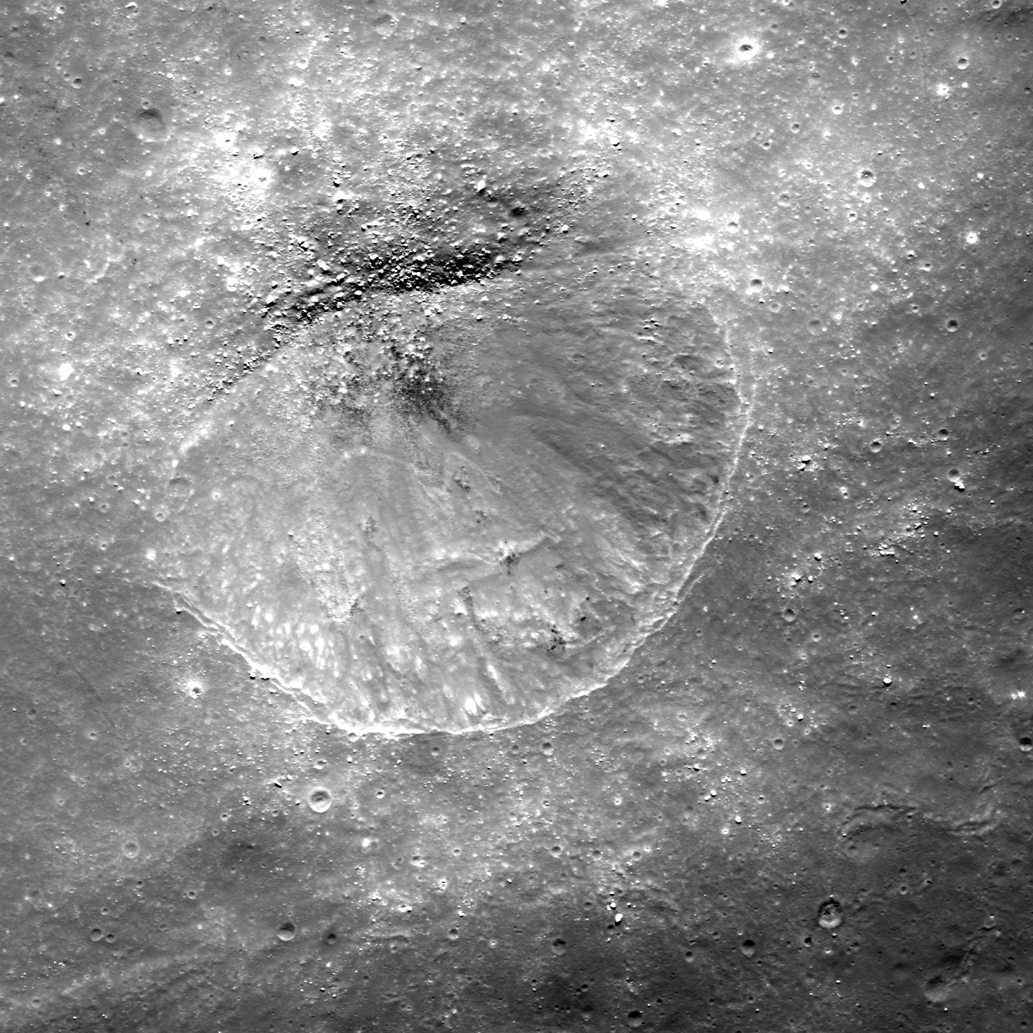
A small 600 meter crater inside the rim of Guthnick, a Copernican impact integral to the Mendlel-Rydberg basin immediately south of Mare Orientalis. This small impact crater exhibits boulders clustered off center, along with a poorly defined rim. Drew Enns asks, "what could be the cause of these distinctive features?" - Crop from LROC Narrow Angle Camera (NAC) M1117124706L, spacecraft orbit 16850, March 5, 2013; 0.60 meters per pixel resolution, above field of view 3 km [NASA/GSFC/Arizona State University].
Drew Enns
LROC News System

Small impact craters are normally bowl-shaped depressions in a planetary surface. Because of this, boulders and impact melt will also fill in the center of the crater. Yet this is not what we observe in today's Featured Image. Why does this small crater have boulders that are off center? Why is the northern portion of the rim undefined? Is it some sort of dynamical fluke? Probably not. It is more likely that there is some uneven terrain influencing the crater. We can zoom out for a larger view.

Asymmetric craters tend to form when the impact angle is greater than 15° The LROC WAC context mosaic helps a lot! We now see that our small crater formed on the wall of the much larger Guthnick crater.

LROC Wide Angle Camera (WAC) context for the small crater (arrow) on the wall of Guthnick crater at 48.27°S, 266.157°E. Though Guthnick is not the subject of this post, the 36 km crater has been identified as one of two that satisfy requirements for sampling intact basin melt sheets. (Science Concept 2: "The structure and composition of the lunar interior provide fundamental information on the evolution of a differentiated planetary body;" CLSE, 2012, pg 115) - LROC WAC observation M112231731CE (604nm), spacecraft orbit 1673, November 7, 2009; resolution 74.25 meters per pixel from 52.51 km [NASA/GSFC/Arizona State University].
The slope of the Guthnick crater's wall had a big effect on the morphology of this simple crater. During the impact event the steep slope resulted in collapse of the downhill portion of the crater, thus the asymmetric shape and collection of boulders on the downhill side.

Still image taken from HDTV feed from Japan's SELENE-1 (Kaguya) orbiting north over the Moon's west limb. The edge of Mare Orientalis has just appeared on the horizon and long chains of impact craters radiate from is central basin. Guthnick, on the right of the two largest craters at the center probably impacted upon one of the long chains, as much as two billion years after the Orientalis event [JAXA/NHK/SELENE]..
The wide-spread and lasting influence of the Orientale basin-forming-impact event can more easily be seen in this LROC WAC digital elevation model. Perhaps at one time the Mendel-Ryder basin, home of Guthnick (white arrow, lower right) though smaller, had an influence nearly as wide spread, wiped away - on the surface at least - 3.1 billion years ago [NASA/GSFC/Arizona State University/DLR].
Explore more of the Guthnick crater interior in a full resolution reproduction of the original LROC NAC, HERE.

Related Posts:
A Tiny Glancing Blow
Clam Shell
Not Your Average Crater

Figure 2.43 (A Global Lunar Landing Site Study to Provide the Scientific Context for Exploration of the Moon, 2012) Topographic profile of Guthnick. Black arrows indicate the transition from upper crater wall to slumped material, as shown by an inflection in the slope. The map uses a polar projection centered on 48°N, 266°E, and the vertical projection of the elevation profile is about 2:1 [CLSE/NLSI/LPI].

Friday, March 29, 2013

Bright small crater ejecta - with a black eye

Fifty meter crater with bright ejecta extending several crater radii. The dark deep interior of the crater could be the disk of of an impact melt pond Field of view 1000 meters across from LROC Narrow Angle Camera (NAC) observation M1117189620R, LRO orbit 16860, March 6, 2013; 0.9 meters resolution [NASA/GSFC/Arizona State University].
Drew Enns
LROC News System

Our impressions (and interpretations) of surface features on planetary bodies are affected by the way they interact with sunlight when we image them.

For instance, the shape of a crater is brought out by shadows in large incidence angles (Sun near the horizon) images.

In today’s Featured Image, we are observing a crater with the Sun nearly directly above the surface. This type of image (small incidence angle) helps scientists understand the physical properties of the surface. Why might the ejecta blanket of the crater be highly reflective? Why is the interior have a much lower reflectance? Two different surface properties could be affecting what we see. First, 'fresh' material should be brighter than surrounding material. And second, the composition of materials affects how they reflect light (see albedo).

A similar, somewhat larger crater for comparison - one also considered to be relatively fresh - in Oceanus Procellarum, northeast of the central eye of the Reiner Gamma albedo swirl. The explicit central melt floor, or disk, may resemble the less clearly resolved fresh crater spot-lighted in this post. You can read the feature story about this comparable crater HERE. LROC NAC observation M111972680L [NASA/GSFC/Arizona State University].
LROC Wide Angle Camera (WAC) context of the region around the small crater highlighted in the LROC Featured Image, located near the red cross (3.022°N, 258.698°E). Image field of view roughly 85 km [NASA/GSFC/Arizona State University].
In the case of today's Featured Image, the crater looks very young. We have some stratigraphic evidence for this as the crater is sitting on top of a larger flesh unnamed crater's ejecta deposit (see context image below).

A quickly put-together crop from the Chang'E-2 (CNSA/CLEP) global medium resolution mosaic, highly emphasizing albedo over the relief made visible by long shadows. Even old and deep craters in this 170 km-wide field of view north of Mare Orientalis seem to disappear under the low solar incidence. If the ejecta blanket from the unnamed crater near center were just a little further east and clearly on the Moon's nearside it would rival the similarly bright ejecta from Tycho, Copernicus or Brygius A. The small crater, clearly overwhelmed in this crop, is marked by a small "X" on he theouter slope of Lents (Lenz) C.
Therefore the brightness of the ejecta blanket is likely due to the young nature of the crater! But that doesn't solve the problem of the crater's interior. The interior could have been mantled by a thin veneer of impact melt which then pooled in the center. We know from many examples that impact melt rock reflects less light than its source material.

The small crater (arrow), situated on the ejecta blanket of a fresh crater further east which, in turn, sits on the wide outer reaches of the Mare Orientalis impact basin. View toward the south, [NASA/ILIADS/LMMP].
The impact melt hypothesis is not certain, though a follow up image at a larger incidence angle to help us understand morphology and could certainly help test this hypothesis!

Explore more ejecta in full the NAC frame, HERE.

Related Posts:
Ejecta Starburst
Swept Surface
Symmetric Ejecta
Shades of Grey

Thursday, March 28, 2013

New Views of the Hollows of Rimae Sosigenes

The Rimae Sosigenes region of northwest Mare Tranquillitatis, from a mosaic of newly released LROC Narrow Angle Camera (NAC) oblique (slew -55°) observations M1108117962LR captured in orbit 15584, November 12, 2012. The field of view is roughly 43 km from west to east (left to right) and scaled up considerably from an original 2.5 meter resolution, imaged from 146 km distance (114.87 km over 8.63°N, 24.9°E, angle of incidence 70.37°).   The largest crater above, Sosigenes A at lower left, is 11.3 km in diameter [NASA/GSFC/Arizona State University].
Joel Raupe
Lunar Pioneer

Running behind this holiday week, we're still busy digging through the latest, 13th batch of Lunar Reconnaissance Orbiter (LRO) data uplinked to the Planetary Data System (PDS) last week. The latest 90 day batch covers September 15 - December 15, 2012, and we're still hopscotching through it like a bee in a springtime garden.

But I wanted to take a moment to talk about hollows. The subject came up at the just-completed 44th Lunar and Planetary Science Conference, last week, in formal discussions about hollows on Mars and Mercury, and that fact reminded me it's been almost exactly a year since the fascinating topic of "meniscus hollows" on the Moon was discussed here.

A new LROC NAC observation of the Rimae Sosigenes area, captured last November, stood out among the few newly-released side-glance, or "oblique," NAC footprints in the latest LROC PDS batch, providing a new perspective on lunar hollows that did not come up in the conversation last year.

Phil Stooke of Western Ontario University collected an excellent inventory of these apparent remnants of gaseous blow-outs and presented it to the 43rd LPSC, last year. He's come up with the designation 'meniscus hollows," as fine description as may be. Among those in his catalog is "No. 8," on the "floor of a depression." 

The new oblique LROC NAC observation assembled at the head of this post shows us how deep that depression really is. Like a necklace encircling the floor of that depression (which resembles a vent, as seen elsewhere on the Moon) where it joins the wall.

A closer look at what was once thought to be a 'chain of craterlets,' a minor catena, slicing perpendicularly through one of a system of parallel north to south rilles - likely faults, that run from Maclear to Sosigenes A. Closer examination in more recent surveys by the LROC Narrow Angle Camera seem to show this structure to be a vent, perhaps related to the faulting. The above is medium resolution sample from  LROC NAC  M1108117962LR [NASA/GSFC/Arizona State University].
Elsewhere we've seen these hollows as hints of relatively recent geological activity, on ancient plains or on small extrusive domes - yet here we seem to see hollows placed in context with a visible complexity of formations with which they may be related. Perhaps some of the other hollows, like those situated alone on the Tranquillitatis plains south of Ross crater and east of Sosigenes, north of Arago and its domes, are all related to conditions under the surface that will turn out at least as complex. 

We don't know enough about Mare Tranquillitatis. It's not clearly an impact basin, like Imbrium and neighboring Serenitatis. It should be interesting to eventually examine the finer detail of these formations in the deeper granularity of the GRAIL mission data.

At Sosigenes faults run south to north parallel with the northwest edge of the mare. Classified as linear rilles, a kilometer or more wide, one is bisected perpendicularly by an 18 km long "gash," hinting at the collapse or shifting under the surface. It is probably immensely old, though at some point the floor of the depression may have been intruded upon from below, perhaps by gases venting at what may have been a weak zone, where the steep 380 meter walls of the depression meet the floor.

In depressed zones east and west of the central "depression of interest," the contact zone joining wall and floor has been blurred by mass wasting. Perhaps in the central depression, however, the distinction was made by material being blown out around the central floor. If so, it's not readily apparent around the outer edge of the formation (which is not the same as saying it isn't there.) Where did it go?

This 580 by 800 pixel sample of the full resolution mosaic (LROC NAC M1108117962LR) shows the 380 meter depths of the elongated formation is punctuated by 'meniscus hollows' very similar to others found just to the east, at the surface of Mare Tranquillitatis south of Ross crater, and more famously at the Ina structure, much further west. Perhaps they most resemble 'hollows' on the floor of the central depression of Rima Hyginus. Found here at the contact zone between the structure's floor and walls, the primary surface seems characterized by a low crater count. Are these hollows points where gases have explosively uncovered the structure's original floor?  [NASA/GSFC/Arizona State University].
 Closer still, in the full-resolution close-up above, something stands out, much as it does at that most famous of the 'meniscus hollows,' Ina. You can make your own comparisons with another new LROC NAC oblique mosaic detailed further below.

In short, the material covering the central depression's floor at its interior, away from the encircling hollows, doesn't appear to share the saturation cratering superpositioned upon it that is more characteristic of the surrounding plain. In fact, like the beaded "frozen liquid' appearance of the material at Ina, it looks relatively new.

A look more or less straight down (and at much higher resolution) at the eastern interior of the 380 meter deep central depression, at its walls together with a small part of the surrounding Rimae Sosigenes plain. Under higher illumination angles the depths of the topography defies our intuition. It doesn't look as deep as it in the oblique view further above, illustrating once again how relief seems to disappear on the Moon in the absence of shadows. From earlier LROC NAC observation M152750200LR, orbit 7645, February 19, 2011; resampled from 0.47 cm per pixel resolution  - angle of incidence 35° - from 39.56 km [NASA/GSFC/Arizona State University].
And an even closer look at one of the hollows along the contact between floor and the steep walls of the central depression at Rimae Sosigenes. Small boulders - apparently - shed from the wall  (and a slope of collapsed talus is piled at right (easier to see in the oblique view above). This field of view, 335 meters wide, comes from LROC NAC observation M177508146LE, LRO orbit 11295, December 2, 2011; angle of incidence 69.92° (slew -14.8°) resolution 0.48 cm per pixel from 37.86 km [NASA/GSFC/Arizona State University].
Optical maturity is no help here, hinting that the newest material is either more than a billion years old or does not result from the kind of kinetic energies released by cratering. In the image above, at bottom center, runs another contact line between the slope of "older" debris from collapsed walls at bottom right and the "newer" material "beaded" at the depression's center.

Is there a difference in the crater count? The material on the slope at bottom right seems darker, but that is likely an illusion from shadow and the elephant skin on nearly every lunar sloped terrain. It hardly counts as a control sample for counting craters and their size and erosion, etc., but no obvious difference in ages stands out between the two zones - nor are there any boulders or trails on either patch of ground. Those seem almost exclusive to the interior of the "blown out" hollows.

Perhaps the best large scale comparison with the meniscus hollows of the Sosigenes depressions is the endlessly compelling Ina formation of Lacus Felicitatis. And that's as good a segue as any to another newly-released LROC NAC oblique observation of that much studied and barely understood feature just below.

A fresh LROC NAC oblique view the Ina formation and its surroundings, a challenge for telescopes on Earth. A closer look at this mosaic's rendition of Ina's distinctive "D" is shown immediately below. Note the apparent rising cone of Mount Agnes, to Ina's northwest. This mosaic is assembled from LROC NAC M1108203502LR, exposing a field of view also roughly 43 km across, with both spacecraft and camera slewed -53°), looking west from 127.29 km over 18.77°N, 11.64°E, Sulpicius Gallus and southern Mare Serenitatis were directly below LRO, outside this side-looking view [NASA/GSFC/Arizona State University].
Perhaps it's a toss-up whether Ina or the hollows on the floor of the central depression of Rima Hyginus more closely resemble the hollows at Rimae Sosigenes. Perhaps the latter is something in-between. 

The view of Ina at an oblique angle, above and below, captured more than 140 km away from the LROC cameras, is not our most detailed look at that formation. Some unscaled examples of the very closest views of Ina surfaced with the LROC PDS release in December 2011. There doesn't seem to be much in the way of a depression resulting from the forces that created Ina, though the beaded remnants or surfacing seems to closely resemble the floor of the Rimae Sosigenes depression.

A new angle on the Ina (3 km across, 18.65°N, 5.3°E) from the immediately preceding mosaic sampled at its full 2.6 meter per pixel resolution [NASA/GSFC/Arizona State University].
Over the next decade or so, when researchers have time to weave together data collected by LROC, Mini-RF and from the GRAIL twins, a better picture of these 'meniscus hollows' will likely emerge. In the end, the formations themselves may turn out to be the surface manifestation of something deeper that we can hardly imagine today.

Related Posts:
Inside Rima Hyginus (June 12, 2012)
Whale of a Hollow (March 20, 2012)
Ina of the Meniscus Hollows (March 21, 2012)
The closest of lunar close-ups (December 16, 2011)
It's a gas, man (October 8, 2011)
Spectral Properties of Ina (February 7, 2011)