Friday, October 24, 2014

Bellcomm’s 1968 Lunar Exploration Program

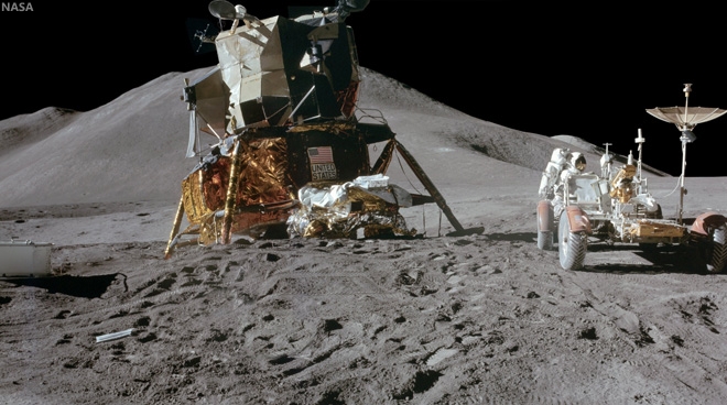
Apollo 15 astronaut James Irwin works beside the mission’s Lunar Roving Vehicle, the first to reach the moon, July 31, 1971. Beginning with Apollo 15, NASA deviated from Bellcomm’s proposed Lunar Exploration Program outlined in 1968 [NASA].
David S. F. Portree
Wired

Bellcomm, Inc., based near NASA Headquarters in Washington, DC, was carved out of Bell Labs in 1962 to provide technical advice to NASA’s Apollo Program Director. The organization rapidly expanded its bailiwick to support nearly all NASA Office of Manned Space Flight advance planning.

In a January 1968 report, Bellcomm planners N. Hinners, D. James, and F. Schmidt proposed a mission series designed to fill a gap which they felt existed in NASA’s lunar exploration schedule between the first piloted Apollo lunar landing and later, more advanced Apollo Applications Program (AAP) lunar flights. The trio declared that their plan was “based upon a reasonable set of assumptions regarding hardware capability and evolution, an increase in scientific endeavor, launch rates, budgetary constraints, operational learning, lead times, and interaction with other space programs,” as well as “the assumption that lunar exploration will be a continuing aspect of human endeavor.”

To bridge the gap between early Apollo and AAP, they envisioned a series of 12 lunar missions in four phases.

Read the full article, HERE.


Thursday, October 23, 2014

China launches lunar sample return test mission

Long March 3C lofts a lunar free-return trajectory and re-entry test module toward cislunar space early Friday morning, October 24, local time. The booster lifted off from Xichang Satellite Launch Center, in China's Sichuan Province, beginning a nine-day mission to 'live fire' test technologies China considers vital to the eventual success of Chang'e-5, a robotic lunar sample return mission now planned for 2017 [Xinhua/Jiang Hongjing].
Test module launch  preparations [CNSA/CLEP].
XICHANG, Sichuan, Oct. 24 (Xinhua) -- China launched an unmanned spacecraft early Friday to test technologies to be used in the Chang'e-5, a future probe that will conduct the country's first moon mission with a return to Earth.

The lunar orbiter was launched atop an advanced Long March-3C rocket from the Xichang Satellite Launch Center in southwest China's Sichuan Province.

The test spacecraft separated from its carrier rocket and entered the expected the orbit shortly after the liftoff, according to the State Administration of Science, Technology and Industry for National Defense.

The whole mission will take about eight days. Developed by China Aerospace Science and Technology Corporation, the spacecraft will fly around the moon for half a circle and return to Earth.

On its return, the test spacecraft will approach the terrestrial atmosphere at a velocity of nearly 11.2 kilometers per second and rebound to slow down before re-entering the atmosphere. It will land in north China's Inner Mongolia Autonomous Region.

The mission is to obtain experimental data and validate re-entry technologies such as guidance, navigation and control, heat shield and trajectory design for a future touch-down on the moon by Chang'e-5, which is expected to be sent to the moon, collect samples and return to Earth in 2017.

It is the first time China has conducted a test involving a half-orbiter around the moon at a height of 380,000 kilometers before having the spacecraft return to Earth.

The test orbiter is a precursor to the last phase of a three-step moon probe project, a lunar sample return mission.

China carried out Chang'e-1 and Chang'e-2 missions in 2007 and 2010, respectively, capping the orbital phase.

The ongoing second phase saw Chang'e-3 with the country's first moon rover Yutu onboard succeed in soft landing on the moon in December 2013. Chang'e-4 is the backup probe of Chang'e-3 and will help pave the way for future probes.

Related Posts:
Geologic characteristics: Chang'E-3 exploration region (January 31, 2014)
ESA on Yutu, as controllers wait for sunrise, February 9 (January 31, 2014)
Problem with solar-powered Yutu rover before nightfall (January 25, 2014)
Chang'e begins long-term science mission (January 18, 2014)
Preliminary Science Results from Chang'e-3 (January 16, 2014)
Chang'e-3 and Yutu survive first lunar night (January 14, 2014)
Chang'e-3 APXS delivers its first surface analysis (January 1, 2014)
Chang'e-3 lander and Yutu rover from LRO (December 31, 2013)
6 of 8 Chang'e-3 science instruments now active (December 18, 2013)
LRO: Finding Chang'e-3 (December 15, 2013)
China's Jade Rabbit, it's time in the Sun (December 15, 2013)
Chang'e-3 Landing Site in Mare Imbrium (December 15, 2013)
Jade Rabbit successfully deployed to the lunar surface (December 14, 2013)
It's not bragging if you do it (December 9, 2013)
"Lunar Aspirations" - Beijing Review (December 9, 2013)
Chang'e-3 safely inserted into lunar orbit (December 6, 2013)
CCTV: Chang'e-3, launch past TLO to Earthview (December 2, 2013)
Chang'e-3 launched from Xichang (December 1, 2013)
Chang'e-3 launch window opens 1 December 1730 UT (November 29, 2013)
Helping China to the MoonESA (November 29, 2013)
Chang'e-3 and LADEE: The Role of Serendipity (October 31, 2013)
Outstanding animation celebrates China's Chang'e-3 (October 29, 2013)
LROC updates image tally of human artifacts on the Moon (September 25, 2013)
Chang'e-3: China's rover mission (May 4, 2013)
China's grand plan for lunar exploration (October 11, 2012)
ILOA to study deep space from Chang'e-3 (September 11, 2012)
China's Long March to the Moon (January 14, 2012)
China plans lunar research base (May 11, 2011)
PRC continues methodical program (March 8, 2011)
Chang'e-2 arrives in mission orbit (October 9, 2010)
Dispatch from Chang'e-2: Sinus Iridum (October 4, 2010)
Chang'e-2 takes direct approach (October 1, 2010)
Chang'e-2 sets stage for future lunar missions (September 3, 2010)
Chang'e-1 research reported published (July 22, 2010)

China to launch sample return re-entry test vehicle

Long March 3C at Xichang [CNSA/CLEP].
Mo Hong'e
Xinhua

China will launch a new lunar mission this week to test technology likely to be used in Chang'e-5, a future lunar probe with the ability to return to Earth.

The experimental spacecraft launched this week is expected to utilize a free-return trajectory to fly high over the Moon's farside and adjust its course for return directly to Earth, according to a source with the State Administration of Science, Technology and Industry for National Defense.

The test module is reportedly in nominal condition and is scheduled to launch sometime prior to local dawn, between Friday and Sunday, from the Xichang Satellite Launch Center.

China's Long March-3C booster will carry the mission through trans-lunar injection.

The mission will involve the spacecraft cislunar navigation, re-entering Earth's atmosphere at above 11 km per second and landing safely on Earth, the source said.

Testing the spacecraft to return land safely at a pre-determined location is considered to be a key capability needed for Chang'e-5, the 2017 mission  designed to land, retrieve lunar samples, launch from the Moon and return the samples to Earth.

Monday, October 13, 2014

LRO: widespread evidence of young lunar volcanism

The feature called Maskelyne is one of many newly discovered young volcanic deposits on the Moon. Called irregular mare patches, these areas are thought to be remnants of small basaltic eruptions that occurred much later than the commonly accepted end of lunar volcanism, 1 to 1.5 billion years ago [NASA/GSFC/Arizona State University].
Dwayne Brown
NASA HQ

NASA’s Lunar Reconnaissance Orbiter (LRO) has provided researchers strong evidence the moon’s volcanic activity slowed gradually instead of stopping abruptly a billion years ago.

Scores of distinctive rock deposits observed by LRO are estimated to be less than 100 million years old. This time period corresponds to Earth’s Cretaceous period, the heyday of dinosaurs. Some areas may be less than 50 million years old. Details of the study are published online in Sunday’s edition of Nature Geoscience.

“This finding is the kind of science that is literally going to make geologists rewrite the textbooks about the moon,” said John Keller, LRO project scientist at NASA’s Goddard Space Flight Center in Greenbelt, Maryland.

The deposits are scattered across the moon’s dark volcanic plains and are characterized by a mixture of smooth, rounded, shallow mounds next to patches of rough, blocky terrain. Because of this combination of textures, the researchers refer to these unusual areas as irregular mare patches.

The features are too small to be seen from Earth, averaging less than a third of a mile (500 meters) across in their largest dimension. One of the largest, a well-studied area called Ina, was imaged from lunar orbit by Apollo 15 astronauts.

Ina appeared to be a one-of-a-kind feature until researchers from Arizona State University in Tempe and Westfälische Wilhelms-Universität Münster in Germany spotted many similar regions in high-resolution images taken by the two Narrow Angle Cameras that are part of the Lunar Reconnaissance Orbiter Camera, or LROC. The team identified a total of 70 irregular mare patches on the near side of the moon.

The large number of these features and their wide distribution strongly suggest that late-stage volcanic activity was not an anomaly but an important part of the moon's geologic history.

The numbers and sizes of the craters within these areas indicate the deposits are relatively recent. Based on a technique that links such crater measurements to the ages of Apollo and Luna samples, three of the irregular mare patches are thought to be less than 100 million years old, and perhaps less than 50 million years old in the case of Ina. The steep slopes leading down from the smooth rock layers to the rough terrain are consistent with the young age estimates.

In contrast, the volcanic plains surrounding these distinctive regions are attributed to volcanic activity that started about 3 1/2 billion years ago and ended roughly 1 billion years ago. At that point, all volcanic activity on the moon was thought to cease.

Several earlier studies suggested that Ina was quite young and might have formed due to localized volcanic activity. However, in the absence of other similar features, Ina was not considered an indication of widespread volcanism.

The findings have major implications for how warm the moon’s interior is thought to be.

An oblique, novel view of the Ina formation (3 km across, 18.65°N, 5.3°E) from the LROC narrow angle camera (resolution 2.5 meters per pixel [NASA/GSFC/Arizona State University].
“The existence and age of the irregular mare patches tell us that the lunar mantle had to remain hot enough to provide magma for the small-volume eruptions that created these unusual young features,” said Sarah Braden, a recent Arizona State University graduate and the lead author of the study.

The new information is hard to reconcile with what currently is thought about the temperature of the interior of the moon.

“These young volcanic features are prime targets for future exploration, both robotic and human,” said Mark Robinson, LROC principal investigator at Arizona State University.

LRO is managed by Goddard for NASA’s Science Mission Directorate at NASA Headquarters in Washington. LROC, a system of three cameras, was designed and built by Malin Space Science Systems and is operated by Arizona State University.

To access the complete collection of LROC images, visit http://lroc.sese.asu.edu/

For more information about LRO, visit http://www.nasa.gov/lro

Some Related Posts:
Hansteen α -   January 15, 2014
Small-scale volcanism on the lunar mare, July 13, 2013
Unassuming volcanic vent north of Aristarchus Plateau, April 1, 2013
New views of the hollows of Rimae Sosigenes, March 28, 2013
Inside Rima Hyginus, June 12, 2012
Ina of the Meniscus Hollows, March 21, 2012
LUNAR MENISCUS HOLLOWS. P. J. Stooke, Department of Geography and Centre for Planetary Science and Exploration, University of Western Ontario, London, Ontario, Canada; 43rd Lunar and Planetary Science Conference (2012), #1011.
Whale of a Hollow, March 20, 2012
It's a gas, man, Paul Spudis, Smithsonian Air & Space, October 6, 2011

Sunday, October 12, 2014

New evidence for young lunar volcanism

One of many newly-discovered young volcanic deposits on the Moon (4.330°N, 33.750°E), this example is near the crater Maskelyne, in south central Mare Tranquillitatis. Illustration from from "New evidence for young lunar volcanism," Mark Robinson, Oct. 12, 2014. LROC NAC observation M1123340138R, LRO orbit 17730, May 16, 2013; slew 3° from orbital nadir, incidence 66.55° resolution 1.04 meters from 102.5 km over 4.26°N, 33.97°E [NASA/GSFC/Arizona State University].
Mark Robinson
Principal Investigator
Lunar Reconnaissance Orbiter Camera (LROC)
Arizona State University

Many young volcanic deposits were recently identified in LROC NAC images. Their sharp nature and general lack of superposed impact craters greater than 20 meters in diameter indicate these deposits probably formed in the last 100 million years, perhaps even more recently than 50 million years ago. An amazing result!

A new paper, (Evidence for basaltic volcanism on the Moon within the past 100 million years, Nature Geoscience 7, 787-791; 2014) presents 70 topographic anomalies, informally called Irregular Mare Patches, or IMPs, most of these occurrences were previously undocumented. The IMPs are thought to be remnants of small basaltic eruptions that formed significantly after the commonly accepted end of lunar volcanism (1 to 1.5 billion years ago).

Locations of IMPs. Red circles indicate either a single IMP greater than 100 meters in diameter, or a cluster of smaller IMPs. The area extends from 28.0° N to 40.6° N latitude and 58.0 ° E to 50.3° E longitude, LROC WAC 643nm mosaic. IMP labels: Aristarchus (A), Gruithuisen E-M region (GEM), Hyginus (H), Ina (I), Mare Nubium (MN),  Mare Tranquillitatis (MT), Marius Hills (MH), Maskelyne (M), Sosigenes (S) [NASA/GSFC/Arizona State University].
Pursuing a Decades-old Puzzle

The best-known IMP, called Ina (or Ina-D), was originally spotted in Apollo 15 orbital photography, and was unlike anything else previously discovered on the lunar surface. Beginning with Apollo era investigations, Ina was interpreted as a collapsed caldera at the summit of a low-shield volcano. Previous interpretations of impact crater densities within and around Ina suggested that this enigmatic landform was much younger than the surrounding mare basalt unit in Lacus Felicitatis (Lake of Happiness).

Not only does the NAC provide excellent resolution, but after 5 years of operation has covered well over 75% of the surface. This combination led to the discovery of many new IMPs in locations across the nearside of the Moon. Ina is not simply a one-off oddity – but rather a signature of volcanic processes that actually occurred in multiple places across the nearside.

Close up of a small 464 meter wide section of the "IMP" familiarly known as Ina. This area is a great example of the difference between the rough and smooth units that make up the new family of IMP structures. The smooth unit is composed of mounds over the rougher units. The Sun is from the East, the black arrows show a Sun-facing cliff of one of the mounds. LROC NAC M175246029LR, LRO orbit 10960, November 6, 2011; 45.6° incidence, resolution 44 cm from 24.54 km over 18.91°N, 4.76°E [NASA/GSFC/Arizona State University].
New Discoveries

All of the lunar landforms identified as IMPs exhibit two distinct morphologies: smooth deposits, which are sometimes connected to the surrounding mare basalt, and uneven deposits (rough-looking) which usually end abruptly at the steep edges of the smooth deposit; it is likely that the smooth materials are covering portions of the rough material.

To estimate the age of IMPs the LROC team measured the sizes and numbers of impact craters on the smooth deposit surfaces (geologists use the crater size-frequency distribution (CSFD) as a metric for estimating the age of a surface). The resulting crater distributions from the three largest irregular mare patches imply ages younger than 100 million years. Indeed, the new crater counts confirmed that Ina is very young, perhaps as young as 33 million years.

IMP north of Aristarchus crater (25.044°N, 313.233°E). Compelling evidence of the youth of this feature and its apparent origination from active processes within the Moon. As a matter of stratigraphy, the phenomena that caused this occurred after the formation of Aristarchus crater, a late Copernican age crater itself superposed on some of the Moon's youngest basaltic volcanic plains. 650 meter-wide field of view from LROC NAC observation M168509312R, LRO orbit 9967, August 20, 2011; incidence 42.67° at 40 cm resolution from 25.59 km over 24.7°N, 313.21°E [NASA/GSFC/Arizona State University].
Another key set of observations came from digital topographic maps derived from NAC stereo pairs that enabled quantitative relief and slope measurements of six larger IMPs. Measurements of the smooth deposit relief compared to the underlying uneven deposit revealed that the thickness of the smooth deposits (on average 8 meters, with a range of 2-20 meters) is consistent with the previously established thickness of lunar basalt flows.

Topographic slopes were measured at the edges of the smooth deposits where they contact the uneven deposits. Slopes that exceed the angle of repose, which is 30-35°, are evidence of relatively young surface features, because over time impacts and moonquakes will smooth over steep cliffs. Slopes on the edges of many of the smooth deposits exceed the angle of repose, providing more evidence for very young surfaces.

Changing the Way We Think About the Moon

Not only are the IMPs striking landscapes, they also tell us something very important about the thermal evolution of the Moon. The nearside has extensive mare basalt flows covering much of its surface, however we know from analysis of Apollo samples and crater counts that the bulk of lunar volcanism occurred from 3.9 to 3.1 billion years ago, and shut-off sometime around 1 billion years ago. However the IMPs seemed to have formed significantly after the canonical cessation of lunar mare basalt volcanism indicating the interior of the Moon is perhaps hotter than previously thought.

The contrast between the smooth and rough units stands out in this oblique view of Ina. The floor of the depression is about 50 m below the surrounding plains and is about 2 km wide. LRO oblique mosaic M1108203502LR, LRO orbit 15596, November 22, 2012; 52.18° slew from orbital nadir, resolution 3.75 meters from 127.29 km over 18.77°N, 11.64°E [NASA/GSFC/Arizona State University].
Full-width reduction of LRO oblique mosaic M1108203502LR, showing the interesting contextual features, some related, others likely not, subject of decades of speculation [NASA/GSFC/Arizona State University].
The new study of IMPs extends our knowledge of the extent of these fascinating deposits as well as their young age. What does it all mean? The young, small-volume extrusions of mare basalt imply a thermal history of the Moon where volcanism did not end abruptly, but rather decreased gradually over time (and may not be done!). With these newly discovered young volcanic features, scientists must consider that the Moon has a bit more heat in it that previously thought, an important new constraint for future models of the Moon's thermal evolution. Perhaps the abundance of radioactive elements (which provide heat as they decay) is higher -- important knowledge when figuring out how the Moon formed and evolved over time.

A provocative side note to the new thermal constraints — perhaps the Apollo heat flow measurements were spot on? Astronauts buried thermometers in the regolith during the Apollo 15 and 17 missions. The temperatures recorded were a bit higher than models predicted. At the time, scientists proposed that perhaps the two landing sites were in areas with higher heat flow than the average Moon, or perhaps there was an instrumental effect. The discovery of IMPs and their young age is certainly consistent with the higher temperatures measured by the Apollo crews.

Apollo 15 cmdr. Dave Scott working at the west Heat Flow hole (with St. George crater in the background). The drill is sitting on the ground next to the hole. Increased understanding of IMP phenomena increases the likelihood readings taken using the Apollo Heat Flow Experiments (HFE) during the Apollo 15 and 17 surface expeditions were not, afterall, anomalous. Apollo 15 EVA-2 AS15-92-12408 [NASA/JSC].
The IMPs are a fascinating part of the story of lunar volcanism over time, and now they must be considered high priority targets for future exploration. A sample return mission from one of these enigmatic deposits would tell us so much about the Moon as a whole. When did these lavas erupt? Is their chemistry different than the basalts returned by the Apollo astronauts? Is it likely that volcanic eruptions may occur at some point in the future?  A highly accurate age date for the IMPs would also serve as a much needed calibration point for the lunar cratering chronology; a crucial improvement not only for lunar studies but also for Mars and Mercury investigations.

Closer look at the IMP at Rimae Sosigenes - image follows below - Demonstrations Supplementary to "Evidence for basaltic volcanism on the Moon within the past 100 million years," Nature Geoscience 7, 787-791; 2014

Fig. 7 (top) Profile across a contact between smooth and uneven deposits, southeast feature. The relief of the smooth deposit is measured as the difference in elevation between the average flat surface of the smooth deposit (-1504 meters below global mean elevation; Sosigenes Graben NAC-DTM) and the base of the uneven deposit at the contact (-1514 meters). For this particular profile the smooth deposit is 10 meters thick. Note the lobate margin of the smooth deposit at the contact.

Fig. 5 (bottom) Craters on the smooth deposit of the Sosigenes IMP. The red circles are impact craters superposed on the smooth deposit of the Sosigenes IMP, delineated by the blue line; field of view roughly 5 km [NASA/GSFC/Arizona State University].
Spectacular oblique mosaic of the Sosigenes graben with it's large collapse pit, 2800 meters long and 300 meters deep, and floored with an IMP.  LROC NAC oblique observation M1108117962LR, LRO orbit 15584, November 21, 2012; 70.37° incidence, spacecraft and camera slew 55° resolution 2.5 meters from 114.87 km over 8.63°N, 24.9°E [NASA/GSFC/Arizona State University].
View full-window: Spectacular oblique NAC mosaic of the Sosignes graben with a large collapse pit (2800 meters wide, left-to-right; 300 meters deep) floored with an IMP.

Wider field of view from a spectacular oblique LROC NAC mosaic M152750200LR, LRO orbit 15584, November 21, 2012; 70.37° incidence, spacecraft and camera slew 55° resolution 2.5 meters from 114.87 km over 8.63°N, 24.9°E [NASA/GSFC/Arizona State University].
Inspect a variety IMPs using the LROC Quickmap: Cauchy-5, Nubium, GEM-30, Aristarchus North

Related Posts:
Inside Rima Hyginus (June 12, 2012)
Ina of the Meniscus Hollows (March 21, 2012)
Spectral properties of Ina (February 7, 2011)

Sunday, September 28, 2014

Resolved Hapke Parameter maps

LROC Wide Angle Camera (WAC) color composite mosaic of the Moon, photometrically normalized using new Hapke parameter maps. Red: 689 nm, green: 415 nm, and blue: 321 nm band; latitude 55°S to 55°N, longitude -68.6° to 41.4°E.
Hiroyuki Sato
LROC News System

After nearly five years of LRO WAC observations, there are over 50 repeat multispectral observations for each ~480 by 480 m2 area on the Moon. The opening image is a new WAC RGB color composite mosaic using ~21 months of observations acquired during the 50 km quasi-circular orbit period. 

One of the most arduous tasks for any planetary remote sensing imaging experiment is photometric correction. What exactly is a photometric correction (or normalization)? When mosaicking together images acquired at different times, image boundaries are often quite obvious because the Sun was in a different position and the camera pointing angles may also have varied. Thus the apparent brightness of the surface can be very different where images overlap.

As the lighting and viewing angles change, the reflectance seen at the camera changes in a non-linear manner (below, left). Photometric normalization adjusts the relative brightness of each pixel in such a way that the apparent camera (emission) angle and the Sun angle are the same in every pixel (e.g. incidence angle (i) = 60°, emission angle (e) = 0°, and phase angle (g) = 60°, see angle geometries below, bottom). 

WAC 643 nm reflectance acquired for a 1° tile (centered at 0.5°N, 181.5°E) as a function of phase angle (top), and diagram of three photometric angles (i, e, and g) in the WAC geometry (bottom). 
For making seamless mosaics or comparing the reflectance at two remote locations, photometric normalization is imperative. Sounds simple, right? In theory the normalization should be simple. However the apparent brightness of the surface as the incidence angle changes is also dependent on grain size, state of maturity, and composition. Many studies have tried to replicate this non-linear reflectance variation for the nearside or for a sample area of the Moon. Typically these corrections work well for that particular area, but not for other portions of the Moon.

To make a global mosaic from the WAC data a new function was needed that accounted for all the variables mentioned above. But how can one account for changes in composition, for example mare vs. highlands? Since we have many complete image sets for the whole Moon, we could divide the Moon into 1° latitude by 1° longitude photometric tiles (64800 tiles). The wide field of view (60° in color mode) of the WAC results in more than 50% overlap with neighboring orbits, providing at least two (and often many more) different observations per 100-meter pixel for each spot on the Moon every month. Using LROC team member Bruce Hapke's photometric model [Hapke, 2012] (a widely applied theoretical model for planetary remote sensing), we parameterized the multispectral and multitemporal reflectance data from each tile (~30x30 km2 area; about 500,000 data points in average), resulting in the near-global Hapke parameter maps of the Moon (see next figure).

Spatially resolved Hapke parameter maps of the Moon for the 643 nm band (Figure 16 in Sato et al. [2014]). Color corresponds to (a) single scattering albedo: w, (b)(c) Henyey-Greenstein double-lobed phase function parameter: b and c, (d) shadow hiding opposition effect amplitude: BS0, (e) shadow hiding opposition effect angular width: hS
The opening WAC color mosaic was photometrically normalized using the Hapke correction and our derived parameter sets (shown in the maps above), achieving a beautiful seamless mosaic. The mosaic shows how well the correction works! Even better, the parameter maps tell us about the nature of the lunar surface. Each of the Hapke parameters has a physical meaning that relates to the material properties of the surface, for example the optical thickness and shape irregularity (b, c), grain size distribution (hS), and of course the albedo (w). This is the first ever resolved Hapke parameter map for any body in our Solar System - a major scientific accomplishment. 

A recently published paper, Sato et al. [2014] in the Journal of Geophysical Research: Planets, describes the detailed methodologies of processing this gigantic data set, estimations of accuracy, the specific Hapke model used, and new discoveries. 

Note that small "holes" in the mosaic are due to shadows or saturation in the original observations.

Thursday, September 25, 2014

Below is a posting for post-doc position at LLNL

The Chemical Sciences Division (CSD) in the Physical and Life Sciences (PLS) Directorate is seeking a planetary sciences postdoctoral researcher. This position requires US citizenship.  

The successful candidate will contribute to several research projects funded by NASA, as well to projects funded by the Department of Energy.  NASA related projects will address the origin and evolution of primordial Solar System condensates, primitive meteorites, lunar samples, and martian meteorites. 

The candidate is expected to have experience with  chemical separation by ion chromatography in a class 100 clean room environment, as with as with isotopic analyses by either multi-collector inductively coupled or thermal ionization mass spectrometry.  This individual will report to the Group Leader for Chemical and Isotopic Signatures.  

Send CV to Lars Borg (borg5@llnl.gov) or Ian Hutcheon (hutcheon1@llnl.gov).

Monday, September 15, 2014

Watching craters "as they happen"

A new crater on the Moon, "found among so many." The bright flash of formation for this approximately 34 meter diameter crater was captured simultaneously by two Earthbound telescopes in Spain on September 11, 2013. From LRO, before-image LROC NAC observation M1119014742L, orbit 17116, March 27, 2013; incidence 23.66° resolution 82 cm from 84.41 km, After-image LROC NAC M1149637354L, LRO orbit 21423, March 16, 2014; incidence 23.18° resolution 91 cm from 89.12 km  [NASA/GSFC/Arizona State University].
Mark Robinson
Principal Investigator
Lunar Reconnaissance Orbiter Camera (LROC)
Arizona State University

On 11 September 2013 the "Moon Impacts Detection and Analysis System" (MIDAS) camera captured a bright 8-second long flash on the central nearside of the Moon.

This was the brightest event captured so far by the MIDAS team, and they estimated that the crater should be between 46 and 56 meters in diameter.

The LROC team targeted the reported coordinates (17.2°S, 339.5°E) of the flash and acquired several images over a few months until the crater was found in images acquired on 16 March 2014 and 13 April 2014.

Strictly speaking, the 11 Sept. 2013 event was visible to the naked eye, though at nearly First Quarter the idealized reproduction above fails to account for the discriminating human eye. The illuminated east hemisphere would tend to have washed out Earthshine for all but those with the steadiest eyes. Fortunately, for at least ten years the unlit portion of the Nearside "visible" at night has been carefully monitored systematically, improving our understanding of hazards in the Near-Earth environment [NASA/GSFC/SVS].
Video sequence recording impact on the Moon's nearside in Mare Nubium. The magnitude of the explosion is estimated to have been roughly equal to that of Polaris, the North Star, and the recorded light curve following after lasted a remarkable eight seconds. Madiedo, et al. (2014) [IAA-CSIC/Universidad de Huelva].

Fortunately there was a NAC image of the target area acquired before the impact, so finding the new crater was relatively easy once an "after" image with comparable lighting to the "before" image was acquired.

As it turns out the new crater is ~34 meters (112 feet) in diameter and is located at 17.167°S, 339.599°E, only 2 kilometers (1.2 miles) from the original telescope-based prediction. In the before-after animation you can see ejecta effects from the crater extend out more than 500 meters in all directions!

See also LROC NAC image M1149637354L (16 March 2014).


Impact flash recorded on the unlit Nearside by Prof. Jose M. Madiedo, 11 Sept. 2013. North is to the right (note the visibility of Grimaldi, top center - the 173 km-wide walled plain is often the last recognizable feature on portion of the Nearside lit by Earthshine as the Moon waxes Full). The Moon was shy of First Quarter. This video was produced on the occasion of the publication (in Feb. 2014) in Monthly Notices of the Royal Astronomical Society (MNRAS) of the paper entitled "A large lunar impact blast on 2013 September 11," by J.M. Madiedo, J.L. Ortiz, N. Morales and J. Cabrera-Caño.

A longer, more instructive version was uploaded by the authors HERE

Wide Angle Camera morphology basemap overlaid with color-coded LROC GLD100 topography centered on the 11 September 2013 impact crater. The large crater just visible in the lower left is 60 kilometer diameter crater Bullialdus [NASA/GSFC/Arizona State University].
Revisit the LROC NAC image of new crater formed on 17 March 2013, HERE.

Read the paper describing the 11 September 2013 observation (Madiedo et al., 2014)

Thursday, September 4, 2014

Secondary scatter over Haret C and the SPA interior

A stream of secondary craters crosses the rim of Haret C (28.47 km; 57.6°S, 186.3°E), stretching from the northeast exterior, southeast into the interior of the crater, deep within the South Pole-Aitken impact basin. 6.52 km-wide field of view from LROC NAC mosaic M1163623161LR, LRO orbit 23388, August 25, 2014; 56.75° incidence, resolution 68 cm from 63.63 km over 57.6°S, 185.26°E [NASA/GSFC/Arizona State University].
H. Meyer
LROC News System

Closely clustered or overlapping craters of similar size and morphology are likely secondary craters.

Secondary craters form when an impactor hits the surface (forming the primary crater) and throws out blocks of material that proceed to form their own craters (secondaries) as they hit the surface.

Sometimes, secondary craters can be difficult to identify if they do not occur in groups. Because craters are used to estimate the age of a surface (a process called crater counting), it is important that scientists are able to identify secondary craters.

Thankfully, in the case of Haret C, the secondary craters stand out from primary craters due to their proximity to each other. Random impacts typically do not form clusters like those draped over Haret C (28.47 km; 57.6°S, 186.3°E) .

A quick look at Haret C made possible by the international burst of lunar exploration briefly inspired by interest in the run-up to the Constellation program. The crater chain is easy enough to see in the medium resolution global albedo mosaic swept up from Chang'e-2. And the basics of the ranges and elevations of the region are displayed using the LROC Quickmap service.
Within high resolution images, smaller craters are used for crater counting. However, secondary craters become more common at smaller diameters introducing a problem for crater counters if the secondaries cannot be distinguished from primary craters. Secondaries counted as primaries result in higher crater counts per unit area, which in turn result in age estimates that are older than the true age of the surface.

Haret C does not dominate, but it is easy to pick out near the center of this HDTV still (larger view HERE) from Japan's lunar orbiter Kaguya (SELENE-1) in 2008. There are two other stills where Haret C and its crater chain are visible in context with central South Pole-Aitken basin and it's larger neighbors Bose (92.5 km; 53.95°S, 190.63°E) and Bhabha (70.52 km; 55.49°S, 194.69°E), HERE and HERE [JAXA/NHK/SELENE].
A key science goal is coming to a better understanding of the morphology or abundance of secondaries relative to primary craters so that more accurate age estimates can be made for smaller, younger terrains: especially important for panning at the scale of the NAC images for future missions to the Moon.

Seven minutes of video from GRAIL-A (Ebb) during orbit 1902 in 2012. Using the student-directed Forward MoonKAM video camera we can close in on the secondary crater chain at Haret C looking north from a perspective beginning at 30 km rising to 41 km over the surface at the end of the sequence. Starting in the polar latitudes of the southern farside the compressed view quickly passes up over the enigmatic interior of South Pole-Aitken basin, over Antoniadi (137.91 km; 69.3°S, 186.94°E, home of the Moon's lowest elevation) north 22° following the meridian that crater shares with Haret C [NASA/JPL/UCSD/SRSC].
Explore the full-width NAC mosaic HERE. Do you see any primary craters in the mix?

Related Posts:

Wednesday, September 3, 2014

Lovely Lichtenberg B

Lichtenberg B (4.86 km; 33.253°N, 298.48°) is a beautifully preserved young impact crater. Rock outcrops in the upper portion of the crater wall are due to the successive thin lava flows that filled Oceanus Procellarum more than 3 billion years ago. LROC NAC mosaic M1162852913LR, LRO orbit 23280, August 16, 2014; incidence angle 35.4° at 1.31 meters resolution, from 129.2 km over 32.46°N, 298.45°E [NASA/GSFC/Arizona State University].
H. Meyer
LROC News System

The lack of atmosphere on the Moon can have its benefits. For example, without an atmosphere, there are few processes to degrade landforms.

On Earth, rain and wind are major causes of erosion, but on the Moon, those causes are absent. Erosion on the Moon is due to impacts that cause shaking and can demolish other craters during formation and to gravity pulling material downslope.

In the case of Lichtenberg B, gravity has not yet rendered the crater smooth and subdued, and there are few impacts nearby, much less any that could have affected the morphology of the crater, as Lichtenberg B appears younger than its neighbors.

Extreme close-up of the wall and rim of Lichtenberg B wall and rim, just east of south center, where impact melt flowed and formed a channel, pushing boulders aside in the process. This 430 meter field of view illustrated "Lichtenberg B Flow," released December 2, 2011. LROC NAC observation M120257109R, February 8, 2010 [NASA/GSFC/Arizona State University].
On the downside, the lack of atmosphere means that space weathering is more efficient on the Moon, and fresh, highly reflective crater ejecta darkens over time. Because Lichtenberg B's ejecta deposit is still bright, it is quite young.

Lichtenberg B and about 56 km-field of view of its surroundings shows an ejecta blanket still highly visible, most than half-way through its long process of optical maturity. LROC monochrome (643 nm) observation M120256944CE, LRO orbit 2856, February 8, 2010; 54.76° incidence angle, 57.42 meters resolution, from 40.39 km [NASA/GSFC/Arizona State University].
Crisp morphology and a highly reflective ejecta deposit make Lichtenberg B stand out from many of the nearby impact craters. This exquisitely preserved crater is located to the northwest of Aristarchus Plateau in Oceanus Procellarum, a vast mare unit littered with impact craters and wrinkle ridges. The ejecta deposit is particularly interesting because it displays a wrinkled texture with structures that resemble dunes.

High-angle (late afternoon) incidence view draws some depth of field to the plains impacted by Lichtenberg B. LROC WAC monochrome (604 nm) mosaic of four observations from sequential passes December 8, 2011; 77° incidence, 56.5 meters resolution from 40 km [NASA/GSFC/Arizona State University].
How do these structures form? What makes Lichtenberg B's ejecta deposit different from other craters that lack these dune-like structures? It turns out that Lichtenberg B is not alone. Scientists have observed these same features at Linné Crater and are in the process of determining how they formed.

Forward view (north) from GRAIL-A gravity probe Ebb MoonKAM in May 2012, over northwest central Oceanus Procellarum. The maturing ejecta blanket from Lichtenberg B, Dorsum Scilla and Naumann G are in mid-foreground, with Naumann further beyond, and Naumann B (10.72 km; 37.46°N, 299.3°E) is nearer the horizon. ( MoonKAM image 133655 ) [NASA/JPL/SRSC/UCSD].
Check out the full NAC mosaic HERE.

Related Posts:

Friday, August 29, 2014

Tadpole and Lava Tube (NAC DTM)

An irregularly shaped depression, resembling a tadpole, first and largest in a sinuous chain of pits. A 14.4 km field of view from LROC Narrow Angle Camera-derived Digital Terrain Model (NAC-DTM) of the tadpole-shaped start of the informally named "Gruithuisen K Sinuous Rille chain" complex in north central Oceanus Procellarum. Color shaded-relief depicts elevation derived from photo-interferometry based on four LROC Narrow Angle Camera observations and resulting in an array of highly granular practical data, packaged into LROC NAC DTM PITVENT; higher elevations are red and white, lower elevations are blue and purple [NASA/GSFC/Arizona State University].
J. Stopar
LROC News System

Today's feature is an irregularly shaped, steep-walled mare depression that looks a bit like a tadpole; it is about 8 km long and located at the northwest end of a 60-km long, sinuous chain of pits (35.284°N, 315.901°E) northwest of Gruithuisen crater.

The pit chain was one of the first and most spectacular candidates proposed for an intact lunar lava tube (i.e., one with uncollapsed segments).

This depression may be the source vent for the lava flows that host the pit chain (see image below).

The unnamed first among many candidate features surveyed for hints of underground voids, lava tubes, etc., west of Gruithuisen K crater in north central Oceanus Procellarum. LROC WAC mosaic swept up over three sequential orbits July 12, 2011; 77.2° incidence, resolution 57.9 meters from 42.5 km [NASA/GSFC/Arizona State University].
Volcanic vents tend to be sub-circular or elongate, like today's feature, which is roughly 600 meters deep and has steep inner walls (~35° slopes). Similarly sized and shaped features include examples near Sulpicius Gallus crater and the Orientale basin. Dark, low-albedo, materials surrounding the Sulpicius Gallus and Orientale features suggest formation through explosive pyroclastic eruptions; however, further exploration is still needed to confirm this interpretation.

Collapse pits, with sharp and nearly vertical walls, like the one in the Marius Hills (shown in a previous post) suggest fairly recent collapse of ancient lava tubes. The chain of pits near Gruithuisen, however, has more subdued topography, and likely formed earlier in the history of the Moon (perhaps more than 1 or 2 billion years ago).

An early mission Commissioning LROC NAC observation, covering a cross-section of the sinuous depression chain. LROC NAC M102443238LR, LRO orbit 272, July 17, 2009; incidence angle 77.85° at 1.54 meters resolution, from 155.56 km over 35.47°N, 316.56°E [NASA/GSFC/Arizona State University].
Intact lava tubes have long been thought to be important to future exploration. Many have speculated that uncollapsed portions of lava tubes could be used to shield explorers from harmful radiation, as well as provide a relatively warm and stable environment that is buffered from the large temperature variations at the surface.

Many hope that uncollapsed lava tubes will be located near volcanic materials that can be used in construction or energy-generation processes. However, we still have not explored inside any lava tubes on another planet, though many engineers and scientists are currently working to enable such activities. In the meantime, LROC images combined with other data sets, can be used to search for additional lava tube candidates.

Explore today's tadpole-shaped vent in more detail: LROC NAC M1103837710.

Continue Reading about this fascinating lava tube candidate and the sinuous pit chain, or explore the Sulpicius Gallus vent and Orientale Basin vent in more detail.

Even more to explore:

Wednesday, August 27, 2014

Pit craters in NAC DTM topography

The crisp morphology of the central Mare Fecunditatis pit (white arrow) stands out in elevation data and suggests a relatively young age. This pit is about 200-m in length and 45 m deep. Image width is 5 km; north is up. Color shaded-relief created from NAC DTM FecundPit; higher elevations shown in red and lower elevations in blue and purple [NASA/GSFC/Arizona State University].
J. Stopar
LROC News System

Eight mare pits have been discovered so far on the Moon, five of which preserve void spaces (sublunarean voids) beneath overhanging mare layers. The pit featured above, located in central Mare Fecunditatis (0.917°S, 48.66°E), however, does not have an obvious void space. The pit is almost 200 m wide and about 45 m deep.

The central Mare Fecunditatis pit has a concave shape, with gentler slopes (outer funnel) near the upper mare surface, and a steeper-walled inner pit (see image below). Variations in wall slopes are consistent with a fine-grained, particulate layer (regolith) overlying more coherent mare layers. The steep inner pit suggests collapse into a small void space. The debris in the pit floor consists of both regolith and mare blocks from the upper layers.

Pit crater (0.92°S, 48.66°E) near Messier B, now generally designated the Central Fecunditatis pit crater to distinguish it for a more recently discovered skylight in southwest Fecunditatis. LRO's longevity has enabled repeated narrow angle photography of selected areas on the Moon, allowing for the team at Arizona State University to build up very high-resolution, NAC-based digital terrain models. 540 meter field of view from LROC NAC observation M1105602888R, LRO orbit 15232, October 23, 2012; 35.18° incidence angle, resolution 93 cm from 108.28 km over 0.92°S, 49°E [NASA/GSFC/Arizona State University]
Left: color shaded-relief of NAC-derived elevation data. Reds are higher elevations, purple lower elevations. Right: elevation profile of a north-to-south cross-section through the pit. The inner pit has steep walls, while slopes near the mare surface (outer funnel) are more gentle [NASA/GSFC/Arizona State University].
The lack of raised rim or ejecta around the pit, indicates that it most likely formed through collapse, rather than as an impact event. While this pit is not located near any obvious tectonic features or volcanic constructs, the collapse may have occurred into part of an old lava tube. The crispness of the pit morphology, suggests that the collapse occurred relatively recently (geologically speaking, at least), perhaps much less than 1 billion years ago. Pits are among some of the youngest landforms on the Moon, and are similar in age to many fresh craters (such as Tycho, Copernicus, or Aristarchus).

More recently identified pit crater in southwest Mare Fecunditatis (6.752°S, 42.76°E), discovered during Wagner and Robinson survey. A 325 meter-wide field of view from LROC NAC M167926438R, LRO orbit 9881, August 14, 2011; 42.25° incidence angle, resolution 56 cm from 26.73 km over 6.71°S, 42.72°E [NASA/GSFC/Arizona State University].
Read More About Lunar Pits:  Lunar pits were recently featured in the news and the focus of a scientific publication ("Distribution, formation mechanisms, and significance of lunar pits," Robert V. Wagner and Mark S. Robinson, Icarus, July 2014; pg. 52-60).

The pits are of particular interest to lunar scientists because they could offer access to subsurface materials, making them important targets for further research and exploration.

Explore the pit in the full-resolution LROC NAC observation HERE.

More Pits: