
 |
| A new study of areas diametrically opposite from the Moon's youngest basins goes beyond crustal magnetic fields and swirl albedo features found at these focal points and proposes examples of highly modified terrain. Animation from preliminary lunar crust thickness maps prepared from GRAIL (2012) data by the Science Visualization Studio. [NASA/GSFC]. |
Lunar Pioneer
Studying the lunar magnetic anomalies and albedo swirls nested near the antipodes, at those points that are absolute opposite on the Moon from its youngest basins, can be a little disorienting. The antipodes of the two most familiar nearside basins Mare Imbrium and Mare Serenitatis, for example, are also near the mountainous northwest and northern border region of the vast (and more ancient) South Pole-Aitken (SPA) basin.
Such simple facts as these, derived during the relatively short history of modern lunar exploration, camouflage a variety of unknowns and complexities, as well as some controversy over the origin of the peculiar features discovered there.
Within ten degrees of the farside coordinates diametrically opposite from the officially designated center of Mare Imbrium, close to the surface, is a fairly well-known local magnetic field. Associated with this crustal magnetism is one of the Moon's most familiar tracings of delicate and bright albedo "swirls," apparently composed of a very thin layer of fine dust of the sort of low optical maturity, a signature of the Moon's youngest features draped over its oldest.
Like some kind of alien graffiti, these swirls really stand out as attributes of Mare Ingenii, the largest lava-flooded plain on the farside, a hemisphere almost as devoid of "seas" as the Moon's Earth-facing side is covered by them.
The Ingenii swirl fields are a highlight of anyone's tour of the Moon. To start considering these giant swirls traced over the surface of Ingenii as integral to Mare Imbrium on the Moon's nearside can sometimes seem like reading through a mirror.
Mare Imbrium is probably the most easily detected 'naked-eye feature' of the tidally-bound Earth-facing hemisphere. Centered officially by the IAU at 34.72°N, 345.09°E, the corresponding, though still preliminary, antipode for the Imbrium basin should be near 34.72°S,165.09°E, on the farside's southern hemisphere.
When we think of the clusters of features often found together near these points directly opposite from the Moon's nearside basins it's often easier to label Mare Ingenii as Imbrium Antipode, and the Gerasimovich region as Crisium Antipode, etc.
This unconventional labeling emerges as we study a whole family of, literally, "far-flung phenomena," though most of the species, fortunately, are not yet associated with a local name. Unlike the more easily spotted features at Mare Ingenii, now thought to have originated with Mare Imbrium, such features elsewhere are less easily picked out, overlapping widely differing terrains and a variety of mountain ranges, plains and crater groups.
The point on the Moon opposite Mare Serenitatis is not as distinctive (see image below). The coordinates were easy enough to determine, like the Imbrium Antipode it's just inside the circumference of SPA basin, a little north and east the antipode of Imbrium as Serenitatis basin, on the nearside, is a little south and east of Imbrium.
Like most of the farside, however, there is no mare-inundated plain near the Serenitatis antipode to allow for a clear photographic contrast with local differences in albedo. The crustal magnetism (or the granularity of our data) seems more diffuse, with smaller, less intense knots of crust magnetism.
The absence on the Moon of the kind of global magnetic field that affords life so much welcome protection here on Earth was one of the earliest conclusions of modern lunar exploration. As men and machines transited to and from the surface, however, the magnetic picture became more complex. The earliest magnetometers, in orbit and on the surface, were detecting magnetic signatures bound to local features, but their local intensity and apparent close association of with surfaces that seemed to defy aging were only beginning to be grasped.
As the Apollo era came to an end it was understood, at least, that the Moon seemed once to have had an internal dynamo like Earth, generating global magnetism fossilized today in its rocks. A higher resolution picture of the Moon's magnetism and its interrelation with the Sun, Earth and its own dust would wait for a second very slowly renewed period of unmanned exploration beginning with vehicles like the DOD remote sensing test platform Clementine (1994).
At the close of the 20th century the remarkable Lunar Prospector (1998-1999) helped add important pieces to the picture. Specifically, the small vehicle returned highly valued data on the Moon's local magnetic fields very close to the surface, as it was gradually lowered toward a planned impact within the permanently shadowed Shoemaker crater, a feature of the far lunar south today baring the name of the celebrated pioneer Gene Shoemaker (1928-1997) who originally planned the impact that inspired the LCROSS mission ten years later.
Investigators have continued to correct and tease valuable information from the sparse Lunar Prospector magnetometer data to this day. The data sometimes allowed identifying lunar features in a manner opposite than before. Reiner Gamma, the most familiar swirl phenomena in Oceanus Procellarum, stands out in low power telescopes. Its associated crustal magnetism was identified later. Elsewhere on the nearside magnetometer data from as few as one to three late mission low orbital passes by Lunar Prospector allowed diffuse albedo patches at Airy and Descartes to be definitively associated with locally intense crustal magnetism and identified as true "swirl phenomena."
At Orientale Antipode, opposite from what is the Moon's unequivocally youngest basin, the swirl field is very widespread, associated with more than a few peaks in local crustal magnetism. The largest affected feature on the opposite side of the Moon from Mare Orientale is Mare Marginis, characterized by what is likely the Moon's largest and most complex field of swirls at the surface, overlapping every kind of terrain, but also closely identified with the Goddard and Goddard A crater. Still, the actual boundaries of this field of 'persistent albedo patterns' are difficult to trace.
Adding to this complexity, the swirl field near Orientale Antipode has been affected by relatively recent impacts, some with brightly reflective rays. The field is spread far enough east, extending over the farside's mid-latitudes, it's difficult to say with certainty whether an unnamed, tightly wound spectacular swirl field east of Firsov crater belongs to the group.
Three investigators with established planetary science resumes which include (among many other things) peer-reviewed study of these bright swirl 'patterns' and associated lunar magnetic anomalies, have recently authored a new study building on continued fine-tuning of Lunar Prospector (1998-1999) magnetometer data and the more recent Lunar Reconnaissance Orbiter (LRO) Wide Angle Camera (WAC) surveys.
The new paper, published in the Journal of Geophysical Research, “Origin of Strong Lunar Magnetic Anomalies: More Detailed Mapping and Examination of LROC Imagery in Regions Antipodal to Young Large Basins,” demonstrates further the recent end to a long controversy, helping answer the Space Age mystery posed by the Moon’s delicate, bright, often sinuous surface albedo patterns.
As with most controversies on the long climb of science, a quiet resolution drew upon bits and pieces collected in pursuit of answers to many, often unrelated, questions.
Launched in early 1998, Lunar Prospector spent 19 months in a low polar orbit and became notorious for a remarkably low budget and high return of valued data as much as for improved mapping of the scattered neutron absorption strongly hinting at the presence of volatiles, specifically hydrogen, prematurely ruled out following early analysis of Apollo samples in 1969.
In 2013 terms, for the amount of money the federal government collects, borrows and spends every eight and a half minutes Lunar Prospector gained a well-deserved reputation and confirmed still skeptically-received indications of the presence of hydrogen, both inside and outside the permanently shadowed regions of the Moon’s polar latitudes.
Such simple facts as these, derived during the relatively short history of modern lunar exploration, camouflage a variety of unknowns and complexities, as well as some controversy over the origin of the peculiar features discovered there.
Within ten degrees of the farside coordinates diametrically opposite from the officially designated center of Mare Imbrium, close to the surface, is a fairly well-known local magnetic field. Associated with this crustal magnetism is one of the Moon's most familiar tracings of delicate and bright albedo "swirls," apparently composed of a very thin layer of fine dust of the sort of low optical maturity, a signature of the Moon's youngest features draped over its oldest.
Like some kind of alien graffiti, these swirls really stand out as attributes of Mare Ingenii, the largest lava-flooded plain on the farside, a hemisphere almost as devoid of "seas" as the Moon's Earth-facing side is covered by them.
The Ingenii swirl fields are a highlight of anyone's tour of the Moon. To start considering these giant swirls traced over the surface of Ingenii as integral to Mare Imbrium on the Moon's nearside can sometimes seem like reading through a mirror.
Mare Imbrium is probably the most easily detected 'naked-eye feature' of the tidally-bound Earth-facing hemisphere. Centered officially by the IAU at 34.72°N, 345.09°E, the corresponding, though still preliminary, antipode for the Imbrium basin should be near 34.72°S,165.09°E, on the farside's southern hemisphere.
 |
| The antipode of Mare Imbrium (yellow spot) was a foci of conjoining seismic shock and ejecta from the epoch-changing basin-forming impact that hollowed out Mare Imbrium, roughly 3.85 billion years ago. Persistent bright surface markings that have lasted beyond the 800 million to 1 billion years thought to inevitably darken lunar regolith are thought to be the result of a cyclical interaction of charged lunar dust precipitating through the locally intense magnetic field. The white rectangle outlines one of many areas of disrupted terrain, "material of grooves and mounds" identified on the geological map of Stuart-Alexander (1978). LROC Wide Angle Camera (WAC) monochrome mosaic [NASA/GSFC/Arizona State University]. |
This unconventional labeling emerges as we study a whole family of, literally, "far-flung phenomena," though most of the species, fortunately, are not yet associated with a local name. Unlike the more easily spotted features at Mare Ingenii, now thought to have originated with Mare Imbrium, such features elsewhere are less easily picked out, overlapping widely differing terrains and a variety of mountain ranges, plains and crater groups.
 |
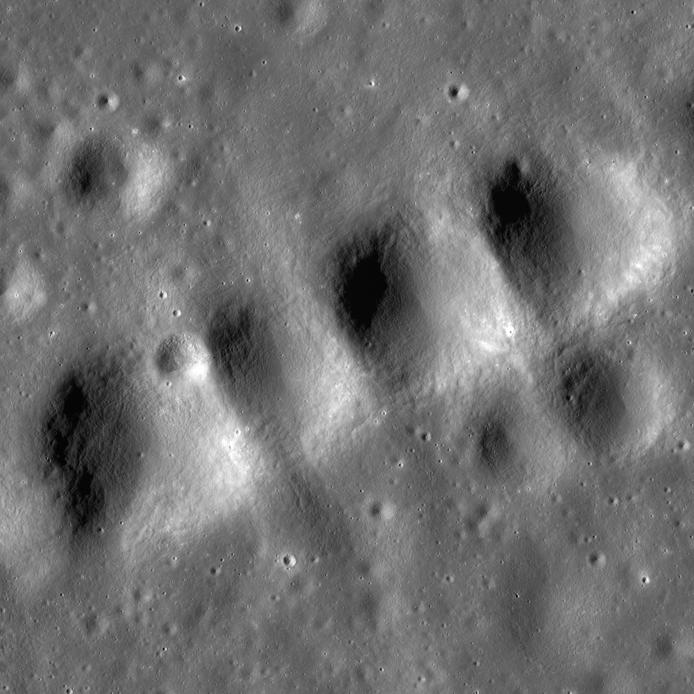
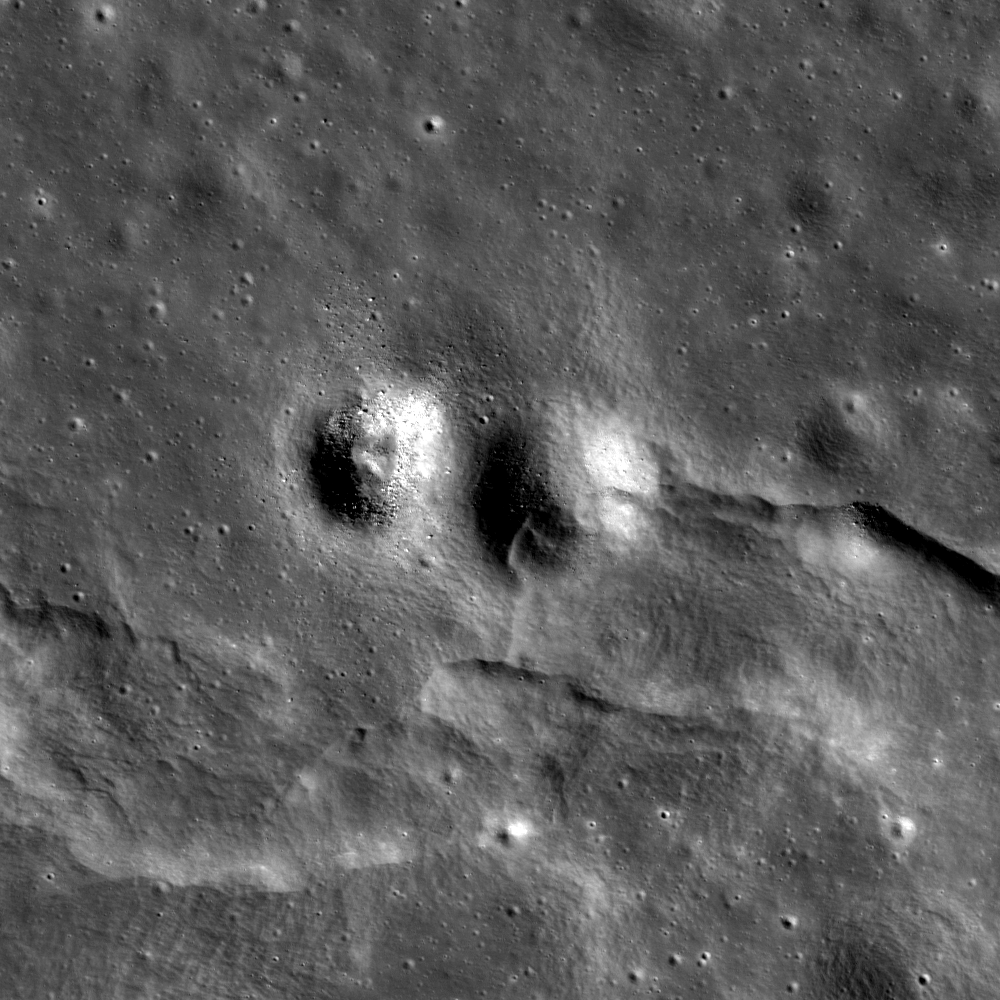
| A very distinctive bifurcated swirl, one of many similar, striking aspects of Mare Ingenii, on the Moon's farside and immediately adjacent to the antipode of Mare Imbrium. From an oblique LROC NAC observation M191830503R, LRO orbit 13304, May 16, 2012 [NASA/GSFC/Arizona State University]. |
Like most of the farside, however, there is no mare-inundated plain near the Serenitatis antipode to allow for a clear photographic contrast with local differences in albedo. The crustal magnetism (or the granularity of our data) seems more diffuse, with smaller, less intense knots of crust magnetism.
The absence on the Moon of the kind of global magnetic field that affords life so much welcome protection here on Earth was one of the earliest conclusions of modern lunar exploration. As men and machines transited to and from the surface, however, the magnetic picture became more complex. The earliest magnetometers, in orbit and on the surface, were detecting magnetic signatures bound to local features, but their local intensity and apparent close association of with surfaces that seemed to defy aging were only beginning to be grasped.
 |
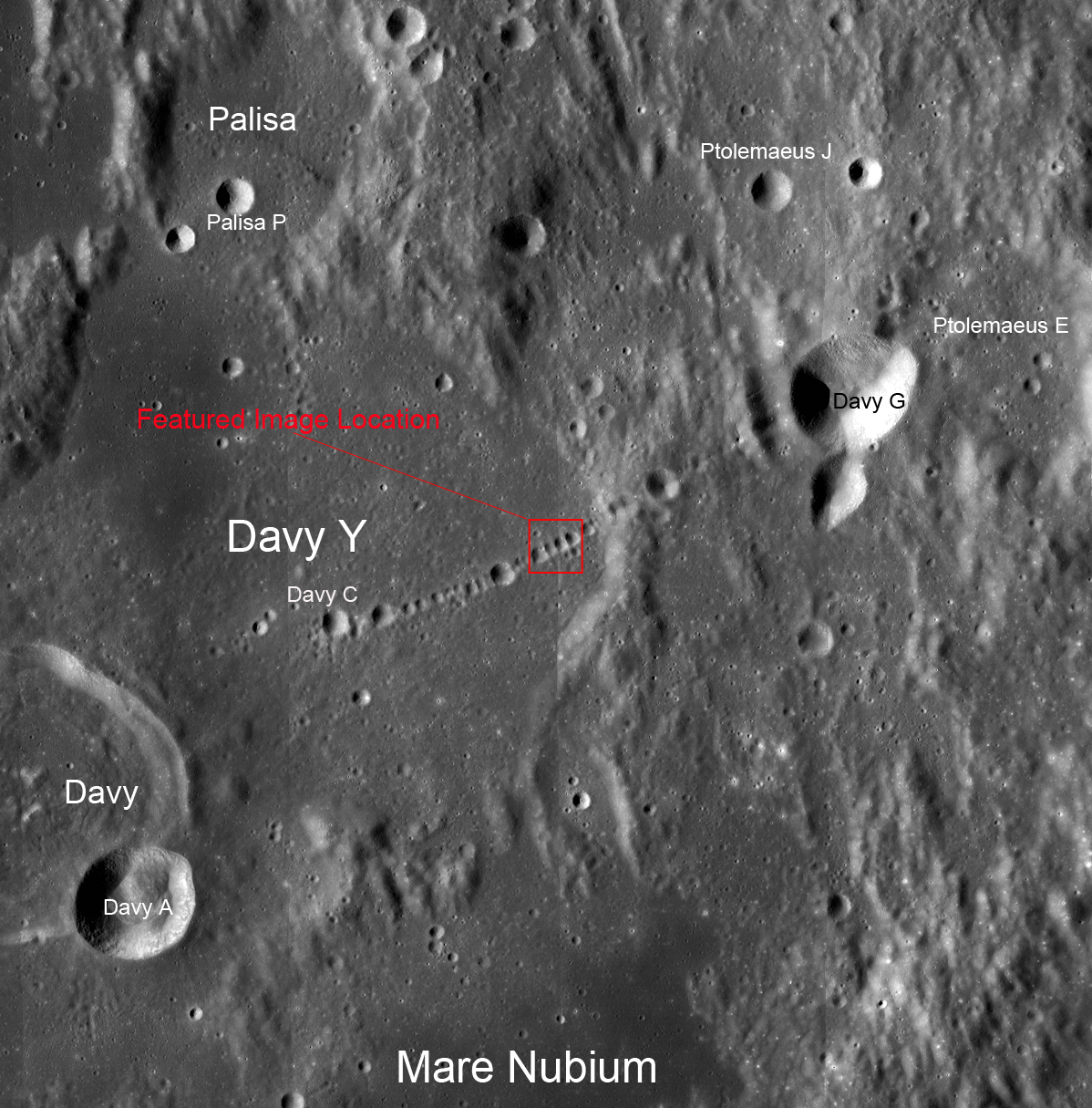
| The Serenitatis Antipode is not as easy for the naked eye to pick out from the background as points opposite the Imbrium basin associated with Mare Ingenii. The antipode of Serenitatis is marked with a cross in frame one (Figure 5 from the study by Hood, et al (2013). In that same frame the authors draw attention to mountains along the rim of SPA basin (white arrows) as possible examples of terrain disrupted by the Serenitatis basin-forming impact here near the opposite point on the Moon. The frame following draws attention to two anomalous optically immature surface areas within Galois Q crater, followed by Clementine color ratio analysis where the older terrain (red) surface areas stand out with characteristics of new (blue) and reflective regolith fines. The twin patches coincide with a local magnetic field strength "bump" measuring 9nT. The final frame shows the same albedo patches at 77 meters resolution in LROC Wide Angle Camera (WAC) observation M160959807C (604 nm), spacecraft orbit 8854, May 25, 2011, angle of incidence 62° from 60 km [NASA/USGS/DOD/GSFC/Arizona State University]. |
At the close of the 20th century the remarkable Lunar Prospector (1998-1999) helped add important pieces to the picture. Specifically, the small vehicle returned highly valued data on the Moon's local magnetic fields very close to the surface, as it was gradually lowered toward a planned impact within the permanently shadowed Shoemaker crater, a feature of the far lunar south today baring the name of the celebrated pioneer Gene Shoemaker (1928-1997) who originally planned the impact that inspired the LCROSS mission ten years later.
Investigators have continued to correct and tease valuable information from the sparse Lunar Prospector magnetometer data to this day. The data sometimes allowed identifying lunar features in a manner opposite than before. Reiner Gamma, the most familiar swirl phenomena in Oceanus Procellarum, stands out in low power telescopes. Its associated crustal magnetism was identified later. Elsewhere on the nearside magnetometer data from as few as one to three late mission low orbital passes by Lunar Prospector allowed diffuse albedo patches at Airy and Descartes to be definitively associated with locally intense crustal magnetism and identified as true "swirl phenomena."
 |
| Figure 9 from Hood, et al (2013) - Superposition of the two-dimensionally filtered magnetic field magnitude at approximately 25 km altitude (Lunar Prospector), contour interval 1 nano-Tesla, onto LROC WAC mosaic of the nearside, in the south-central highlands vicinity of the Apollo 16 landing site. |
 |
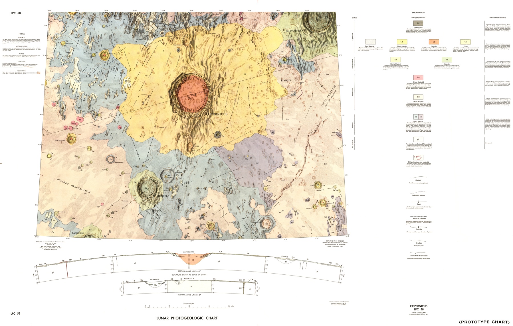
| Simulated oblique view over ancient Descartes crater (29 km - 11.74°S, 15.66°E), from the Cayley Formation plains explored by Young and Duke on the Apollo 16 expedition (1972) in the northwest around 80 km southeast over the "disrupted terrain" of the Descartes Formation, highlighting its anomalous albedo, not coincidentally at the heart of one of the Moon's most intense crustal magnetic fields. LROC WAC mosaic, from observations collected in three sequential orbital passes December 3, 2011, averaging 52 meters resolution from 38 km - Figure 5 from "Boulder 668 at Descartes C," July 17, 2012 [NASA/GSFC/Arizona State University]. |
Adding to this complexity, the swirl field near Orientale Antipode has been affected by relatively recent impacts, some with brightly reflective rays. The field is spread far enough east, extending over the farside's mid-latitudes, it's difficult to say with certainty whether an unnamed, tightly wound spectacular swirl field east of Firsov crater belongs to the group.
 |
| The Orientale Antipode (near Goddard A) is characterized by very widespread swirls. The greater manifestation (large oval) extends far from the pronounced magnetic field lines of peak strength near Hubble, Goddard and Goddard A craters east nearly to a distant and weaker peak field strength associated with the spectacular field of swirls seemingly spilling out from a bright unnamed Copernican crater east of Firsov (4.204°N, 112.697°E). LROC WAC global 100 meter mosaic [NASA/GSFC/Arizona State University]. |
The new paper, published in the Journal of Geophysical Research, “Origin of Strong Lunar Magnetic Anomalies: More Detailed Mapping and Examination of LROC Imagery in Regions Antipodal to Young Large Basins,” demonstrates further the recent end to a long controversy, helping answer the Space Age mystery posed by the Moon’s delicate, bright, often sinuous surface albedo patterns.
 |
| A crew member on-board Apollo 10 almost managed to capture the full length of the magnificent but unnamed surficial albedo swirl field now associated with a measurable peak in crustal magnetism east of Firsov crater. AS10-30-4365 [NASA]. |
Launched in early 1998, Lunar Prospector spent 19 months in a low polar orbit and became notorious for a remarkably low budget and high return of valued data as much as for improved mapping of the scattered neutron absorption strongly hinting at the presence of volatiles, specifically hydrogen, prematurely ruled out following early analysis of Apollo samples in 1969.
In 2013 terms, for the amount of money the federal government collects, borrows and spends every eight and a half minutes Lunar Prospector gained a well-deserved reputation and confirmed still skeptically-received indications of the presence of hydrogen, both inside and outside the permanently shadowed regions of the Moon’s polar latitudes.
“Will your grace command me any service to the world's end? I will go on the slightest errand now, to the Antipodes that you can devise to send me on…”- Much Ado About Nothing, (Act II, scene 2)
The planned mission-ending impact of Lunar Prospector on the permanently shadowed floor of Shoemaker crater, near the Moon’s South Pole, July 30, 1999 (a long-shot, ultimately unsuccessful attempt to send up a plume of volatiles detectable from Earth), inspired the very successful LCROSS mission, launched together with LRO, a decade later.
With its neutron spectrometer, mapping the absence, the absorption, of scattered neutrons indicative of hydrogen, possibly water ices, near the lunar poles, Lunar Prospector also deployed a sensitive magnetometer.
The Moon’s lack of an Earth-like global magnetic field was well known, though Apollo and Luna surface samples clearly indicated the Moon may once have had the kind of molten internal dynamo at its core we take for granted on Earth, a now-dormant generator sufficient for global magnetism, its signature locked into the lineup direction of certain materials as volcanic rock cooled in its earliest ages, some of these as much as a billion years apart. The magnetic fields detected at the surface and from orbit, speculation held, were likely fossilized remnants, surviving islands – though the presence of “lunar magnetic anomalies” on the Moon’s Farside, in concentrations near opposite on the Moon (antipodal) from the Nearside’s large basins was seen as an unlikely coincidence very early in post-Apollo studies.
Along with anomalous local crustal magnetism detected near the Moon’s most famous “swirl,” the alluring Reiner Gamma, bright against the darker background of Oceans Procellarum, and the presence of swirls, some of them spectacular, in vicinity of these islands of knotted magnetic field lines - at the antipodes of Mare Imbrium and Serenitatis - was impossible to ignore.
Very near the Antipodes of Mare Imbrium in particular, the earliest photographs of the Moon’s Farside unveiled a spectacular swirl “field,” seeming almost intelligent in origin, Minimalist butterflies or spiders, strange forms seemed lightly painted in white on the darker floor of the melt-inundated basin floor of Mare Ingenii, by some inscrutable giant almost evoking the walls and ceilings of the cave of Lascaux, or the Nazca Lines.
“Swirls” seem immune from “optical maturity,” an inevitable darkening (really reddening) by solar and cosmic radiation. Incessant bombardment should inevitably weather fade such contrast to match its surroundings, on a timescale between 800 million to 1 billion years.
Had there had been any indication the bright patterns were composed of rough, fresh and reflectively bright small ejecta, like the rays of young 109 million year old Tycho, for example, a predictable cycle of meteorite and micro-meteorite “gardening” turns over the upper 3 centimeters of the entire lunar surface each two million years. Space weather, therefore, should have contributed to their erasure. It was a strong argument for direct, or lacking any difference in the crater counts inside and outside the swirls, indirect encounters with comets.
The comet encounter theory for the origin of lunar swirls died hard. Proponents pointed to the optical immaturity, the undeniably fresh material of the brighter surface, and claimed this to be evidence that outweighed other factors.
The predominance of Farside swirls gathered near places opposite from the Nearside basins and in the presence of coincident local crustal magnetism, they wrote, pointed perhaps to relatively recent and oblique encounters with comets interacting electro-chemically with these unusual conditions. The still-interesting fact that Reiner Gamma, and two lesser known magnetic anomalies with accompanying bright albedo patches on the Nearside seemed to lack any identified basins at their opposing antipodes on the Farside, they claimed, was also exceptional.
As the recorded readings measured from the Lunar Prospector magnetometer were gradually corrected, properly matched with time, the pressures of sunlight, etc., over many years following the end of that mission in 1999, researchers began discovering, or confirming, the existence of swirls after first deciphering the location of smaller, though sometimes intense, magnetic fields.
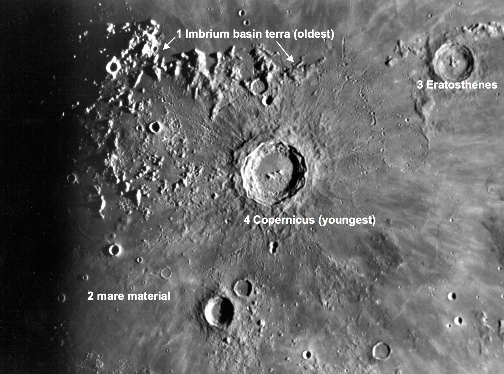
Ironically, the most intense magnetic field detected by any of the Apollo surface expeditions, that of Apollo 16, was measured only 80 km northwest of possibly the most intense crustal magnetism on the Moon, together with the amorphous small brighter surface material of the Descartes Formation. John Young and Charlie Duke walked on the northwestern edge of this feature when sampling the Cinco craters on “Stone Mountain,” overlooking South Ray crater, in April 1972.
The Lunar Prospector magnetometer survey of the Moon made for an improvement on earlier maps, but the mission was not comprehensive. Its advantage, at the time, was an unprecedented low orbit, an orbital altitude gradually lowering more and more as the vehicle approached its demise. The data had an inherent high degree of accuracy because of improvements in electronics and hardened electronics since the Apollo era, and a value-added accuracy due to the patience and hard work of investigators properly pegging the to geography and time, in filtering out the noise long after Lunar Prospector was gone.
Much of what is now known about the lunar magnetic anomaly on the Descartes highland hugging the northern edge of ancient Descartes crater, was teased from its measurements taken through three late mission orbits, when Lunar Prospector orbited some 32 km first over the east, and in the next orbit passing directly over Descartes, and last over the west.
Hood and Richmond, authors of this latest study, published their examination of the Lunar Prospector encounter with Descartes in 2003, determining the intensity of the very local magnetic field sufficient to refract the solar wind, dubbing it a “mini-magnetosphere.”
At nearly the same time, similarly strong local magnetic anomalies, though slightly less intense and localized, were shown embedded on the Farside at Gerasimovich, and perhaps elsewhere.
Some were quick to speculate, if a crustal magnetism centered on the Descartes formation were strong enough to refract the solar wind, perhaps such protection prevented the dusty surface of the bright “swirl” on the southern half of “Stone Mountain” from becoming “optically mature.”
The authors were quick to point out in their introductory paper even such an obviously intense local magnetic field offered no protections from heavier cosmic radiation. The depth of the cavity in the solar wind formed by Descartes magnetic anomaly was insufficient to stop highly energetic, and heavy, nucleons traveling – unlike the particles of a solar wind – close to the speed of light. They estimated such a purpose would require a magnetic field 2,000 km across just to begin deflecting highly energetic cosmic rays away from the surface within the fields. Naturally, such a field would have no effect on the patient and steady rain of micro-meteorites adding to the surface maturity.
Ignoring, for the moment, most magnetic anomalies with their attendant swirls are not sufficiently intense to carve out a transitory cavity in the solar wind, the authors demonstrated the most astonishingly enduring, and intense magnetic field ever detected near the lunar surface was no protection from space weathering.
By all rights, the surfaces within their influence should be darkening at or close to the same rate as the lunar surface elsewhere.
Enter Kaguya, Chandrayaan, LRO…
Toppography.
For decades the nature and the origin or the swirl patterns stirred very minor controversy, in planetary science communities. Those who insisted lunar swirls originated from comet encounters
Early in the Space Age investigators concluded our Moon, unlike Earth,
One place suggested as a possible location for samples of the SPA basin is northeast of Plato, where, between that famous crater and the long northern edge of Mare Frigoris, probability points toward the possible existence of a debris pile, the antipodes of the South Pole-Aitken basin.
In this latest study, Hood, Richmond and Spudis add granularity to our understanding the relationship between basin forming impacts and how they modify the landscape at the most remote points possible, as far away from Ground Zero as anyone can get, and remain on the Moon.
Anyone can meditate on Mare Imbrium, for example, and see how energetic the pressure wave, racing away from the center of the impact, scoured out mountains and channels and hurled away and dumped unimaginable masses of melt and solid debris many hundreds of kilometers away. The scar has not been erased, and a significant amount of debris must have been ejected at escape velocity. Much of that material eventually returned or settled elsewhere in the Solar System.
On February 15, 2013, as many in the far-flung world’s astronomy community were preparing to observe an exceptionally close fly-by of asteroid 2012 DA14, out of the glare of the pre-dawn over Central Asia a 7,000 ton, 15 meter-wide rock encountered Earth’s atmosphere at a relative speed of 18 km per second. Immediately flaring bright, it quickly exploded 20 km overhead. The event produced a shockwave into the atmosphere over Chelyabinsk that immediately imparted ten times the energy of the fission bomb exploded over Hiroshima in 1945. The sound of that smaller asteroid’s explosion traveled around the entire planet several times before seismic stations of the world could detect it no longer.
The pressure wave from the Chelyabinsk Event propagated in every direction away from the explosion until all points on the wave converged west-southwest of South America, where the far South Pacific borders the Great Southern Ocean encircling Antarctica. The momentum of the wave through the atmosphere carried past this convergence point, the Antipode of the Chelyabinsk Event, and continued racing away until a second convergence occurred many hours later, back over Russia, where the energy continued on toward the antipode a second time, and so on, like ripples in a pond – only the pond, in this case, was a planet, and its shoreline a single point on the opposite side of the world.
Related Posts:
Bubble, Bubble – Swirl and Trouble (July 19, 2012)
Boulder 668 at Descartes C (July 16, 2012)
LROC: The Swirls of Mare Ingenii (June 22, 2012)
Remnant magnetism hints at once-active lunar core (January 27, 2012)
Grand lunar swirls yielding to LRO Mini-RF (October 4, 2010)
Another look at Reiner Gamma (June 30, 2010)
LOLA: Goddard (June 26, 2010)
Depths of Mare Ingenii (June 16, 2010)
LROC: Ingenii Swirls at Constellation Region of Interest (May 26, 2010)
Local topography and Reiner Gamma (May 22, 2010)
Lunar swirl phenomena from LRO (May 17, 2010)
The still-mysterious Descartes formation (May 11, 2010)
Dust transport and its importance in the origin of lunar swirls (February 21, 2010)
The Heart of Reiner Gamma (November 17, 2009)
Moon’s mini-magnetospheres are old news (November 16, 2009)
MIT claim of solving ‘lunar mystery’ unfounded (January 15, 2009)
With its neutron spectrometer, mapping the absence, the absorption, of scattered neutrons indicative of hydrogen, possibly water ices, near the lunar poles, Lunar Prospector also deployed a sensitive magnetometer.
The Moon’s lack of an Earth-like global magnetic field was well known, though Apollo and Luna surface samples clearly indicated the Moon may once have had the kind of molten internal dynamo at its core we take for granted on Earth, a now-dormant generator sufficient for global magnetism, its signature locked into the lineup direction of certain materials as volcanic rock cooled in its earliest ages, some of these as much as a billion years apart. The magnetic fields detected at the surface and from orbit, speculation held, were likely fossilized remnants, surviving islands – though the presence of “lunar magnetic anomalies” on the Moon’s Farside, in concentrations near opposite on the Moon (antipodal) from the Nearside’s large basins was seen as an unlikely coincidence very early in post-Apollo studies.
Along with anomalous local crustal magnetism detected near the Moon’s most famous “swirl,” the alluring Reiner Gamma, bright against the darker background of Oceans Procellarum, and the presence of swirls, some of them spectacular, in vicinity of these islands of knotted magnetic field lines - at the antipodes of Mare Imbrium and Serenitatis - was impossible to ignore.
Very near the Antipodes of Mare Imbrium in particular, the earliest photographs of the Moon’s Farside unveiled a spectacular swirl “field,” seeming almost intelligent in origin, Minimalist butterflies or spiders, strange forms seemed lightly painted in white on the darker floor of the melt-inundated basin floor of Mare Ingenii, by some inscrutable giant almost evoking the walls and ceilings of the cave of Lascaux, or the Nazca Lines.
“Swirls” seem immune from “optical maturity,” an inevitable darkening (really reddening) by solar and cosmic radiation. Incessant bombardment should inevitably weather fade such contrast to match its surroundings, on a timescale between 800 million to 1 billion years.
Had there had been any indication the bright patterns were composed of rough, fresh and reflectively bright small ejecta, like the rays of young 109 million year old Tycho, for example, a predictable cycle of meteorite and micro-meteorite “gardening” turns over the upper 3 centimeters of the entire lunar surface each two million years. Space weather, therefore, should have contributed to their erasure. It was a strong argument for direct, or lacking any difference in the crater counts inside and outside the swirls, indirect encounters with comets.
The comet encounter theory for the origin of lunar swirls died hard. Proponents pointed to the optical immaturity, the undeniably fresh material of the brighter surface, and claimed this to be evidence that outweighed other factors.
The predominance of Farside swirls gathered near places opposite from the Nearside basins and in the presence of coincident local crustal magnetism, they wrote, pointed perhaps to relatively recent and oblique encounters with comets interacting electro-chemically with these unusual conditions. The still-interesting fact that Reiner Gamma, and two lesser known magnetic anomalies with accompanying bright albedo patches on the Nearside seemed to lack any identified basins at their opposing antipodes on the Farside, they claimed, was also exceptional.
As the recorded readings measured from the Lunar Prospector magnetometer were gradually corrected, properly matched with time, the pressures of sunlight, etc., over many years following the end of that mission in 1999, researchers began discovering, or confirming, the existence of swirls after first deciphering the location of smaller, though sometimes intense, magnetic fields.
Ironically, the most intense magnetic field detected by any of the Apollo surface expeditions, that of Apollo 16, was measured only 80 km northwest of possibly the most intense crustal magnetism on the Moon, together with the amorphous small brighter surface material of the Descartes Formation. John Young and Charlie Duke walked on the northwestern edge of this feature when sampling the Cinco craters on “Stone Mountain,” overlooking South Ray crater, in April 1972.
The Lunar Prospector magnetometer survey of the Moon made for an improvement on earlier maps, but the mission was not comprehensive. Its advantage, at the time, was an unprecedented low orbit, an orbital altitude gradually lowering more and more as the vehicle approached its demise. The data had an inherent high degree of accuracy because of improvements in electronics and hardened electronics since the Apollo era, and a value-added accuracy due to the patience and hard work of investigators properly pegging the to geography and time, in filtering out the noise long after Lunar Prospector was gone.
Much of what is now known about the lunar magnetic anomaly on the Descartes highland hugging the northern edge of ancient Descartes crater, was teased from its measurements taken through three late mission orbits, when Lunar Prospector orbited some 32 km first over the east, and in the next orbit passing directly over Descartes, and last over the west.
Hood and Richmond, authors of this latest study, published their examination of the Lunar Prospector encounter with Descartes in 2003, determining the intensity of the very local magnetic field sufficient to refract the solar wind, dubbing it a “mini-magnetosphere.”
At nearly the same time, similarly strong local magnetic anomalies, though slightly less intense and localized, were shown embedded on the Farside at Gerasimovich, and perhaps elsewhere.
Some were quick to speculate, if a crustal magnetism centered on the Descartes formation were strong enough to refract the solar wind, perhaps such protection prevented the dusty surface of the bright “swirl” on the southern half of “Stone Mountain” from becoming “optically mature.”
The authors were quick to point out in their introductory paper even such an obviously intense local magnetic field offered no protections from heavier cosmic radiation. The depth of the cavity in the solar wind formed by Descartes magnetic anomaly was insufficient to stop highly energetic, and heavy, nucleons traveling – unlike the particles of a solar wind – close to the speed of light. They estimated such a purpose would require a magnetic field 2,000 km across just to begin deflecting highly energetic cosmic rays away from the surface within the fields. Naturally, such a field would have no effect on the patient and steady rain of micro-meteorites adding to the surface maturity.
Ignoring, for the moment, most magnetic anomalies with their attendant swirls are not sufficiently intense to carve out a transitory cavity in the solar wind, the authors demonstrated the most astonishingly enduring, and intense magnetic field ever detected near the lunar surface was no protection from space weathering.
By all rights, the surfaces within their influence should be darkening at or close to the same rate as the lunar surface elsewhere.
Enter Kaguya, Chandrayaan, LRO…
Toppography.
For decades the nature and the origin or the swirl patterns stirred very minor controversy, in planetary science communities. Those who insisted lunar swirls originated from comet encounters
Early in the Space Age investigators concluded our Moon, unlike Earth,
One place suggested as a possible location for samples of the SPA basin is northeast of Plato, where, between that famous crater and the long northern edge of Mare Frigoris, probability points toward the possible existence of a debris pile, the antipodes of the South Pole-Aitken basin.
In this latest study, Hood, Richmond and Spudis add granularity to our understanding the relationship between basin forming impacts and how they modify the landscape at the most remote points possible, as far away from Ground Zero as anyone can get, and remain on the Moon.
Anyone can meditate on Mare Imbrium, for example, and see how energetic the pressure wave, racing away from the center of the impact, scoured out mountains and channels and hurled away and dumped unimaginable masses of melt and solid debris many hundreds of kilometers away. The scar has not been erased, and a significant amount of debris must have been ejected at escape velocity. Much of that material eventually returned or settled elsewhere in the Solar System.
On February 15, 2013, as many in the far-flung world’s astronomy community were preparing to observe an exceptionally close fly-by of asteroid 2012 DA14, out of the glare of the pre-dawn over Central Asia a 7,000 ton, 15 meter-wide rock encountered Earth’s atmosphere at a relative speed of 18 km per second. Immediately flaring bright, it quickly exploded 20 km overhead. The event produced a shockwave into the atmosphere over Chelyabinsk that immediately imparted ten times the energy of the fission bomb exploded over Hiroshima in 1945. The sound of that smaller asteroid’s explosion traveled around the entire planet several times before seismic stations of the world could detect it no longer.
The pressure wave from the Chelyabinsk Event propagated in every direction away from the explosion until all points on the wave converged west-southwest of South America, where the far South Pacific borders the Great Southern Ocean encircling Antarctica. The momentum of the wave through the atmosphere carried past this convergence point, the Antipode of the Chelyabinsk Event, and continued racing away until a second convergence occurred many hours later, back over Russia, where the energy continued on toward the antipode a second time, and so on, like ripples in a pond – only the pond, in this case, was a planet, and its shoreline a single point on the opposite side of the world.
Related Posts:
Bubble, Bubble – Swirl and Trouble (July 19, 2012)
Boulder 668 at Descartes C (July 16, 2012)
LROC: The Swirls of Mare Ingenii (June 22, 2012)
Remnant magnetism hints at once-active lunar core (January 27, 2012)
Grand lunar swirls yielding to LRO Mini-RF (October 4, 2010)
Another look at Reiner Gamma (June 30, 2010)
LOLA: Goddard (June 26, 2010)
Depths of Mare Ingenii (June 16, 2010)
LROC: Ingenii Swirls at Constellation Region of Interest (May 26, 2010)
Local topography and Reiner Gamma (May 22, 2010)
Lunar swirl phenomena from LRO (May 17, 2010)
The still-mysterious Descartes formation (May 11, 2010)
Dust transport and its importance in the origin of lunar swirls (February 21, 2010)
The Heart of Reiner Gamma (November 17, 2009)
Moon’s mini-magnetospheres are old news (November 16, 2009)
MIT claim of solving ‘lunar mystery’ unfounded (January 15, 2009)


