The NASA mission
GRAIL (Gravity Recovery And Interior Laboratory) has been orbiting the Moon since last spring. The mission consists of two identical small spacecraft (dubbed Ebb and Flow) that very carefully keep track of their relative position from each other. By tracking both of these spacecraft with high precision from Earth, we can monitor any small variations (caused by variations in the Moon’s gravity field) away from their predicted orbital paths. If the satellite is flying over an area on the Moon with less material than normal (for example, over a deep crater, a hole in the Moon’s crust), it will be less attracted to the Moon because of this mass deficiency and will therefore fly away from the Moon. If, on the other hand, it flies over an area of excess mass, such as a thick stack of dense lava flows, the excess mass pulls the satellite slightly toward it, increasing its speed and pulling it downwards. As Ebb and Flow orbit the Moon, they conduct a delicate “dance.” These movements are caused by variations in the Moon’s gravity (largely a reflection of variations in the density of its crustal rocks). When combined with the high-resolution, precision topography of the Moon (currently being gathered by the Lunar Reconnaissance Orbiter), we are able to reconstruct the structure and thickness of the lunar crust from orbit.
GRAIL has unveiled a new global gravity data set, very high in resolution and precision and greater than ten times better than our previous version of the global gravity from the Japanese mission
SELENE (
Kaguya). One interesting result shows unusual structure –
long, quasi-linear gravity features appear in a variety of locations associated with lunar impact basins. Basins are very large craters that formed during asteroid collisions prior to 3.8 billion years ago. Some of these linear features extend on great circles across the lunar globe for distances of more than 500 km. These results suggest that solidified intrusions of once-molten rock may form a dense, criss-crossing network within the upper crust.
In order to understand the significance of these gravity features, it is necessary to understand some elementary facts about planetary geology. Planets generate heat and this heat must be dissipated. Typically, the heat generated from both the original energy release during formation (accretion) and from the decay of radioactive elements (e.g., uranium) melts the interiors of planets, forming bodies of liquid rock called
magma. This magma is usually less dense than the rocks from which it forms and thus, rises upwards towards the surface. Sometimes, the molten rock cannot ascend any higher from the deep locations where it comes from and freezes in place – geologists call this type of frozen rock body an
intrusion, because it intrudes into pre-existing rock as a liquid and then solidifies by crystallizing. When magma actually reaches the surface of a planet, it can erupt onto its surface as lava; this activity is called extrusive because the molten rock extrudes onto the surface and then solidifies as lava flows.
Clearly, all erupting lava must have at one time been an intrusive magma body, at least during the time it was ascending upwards toward the surface. Although many magma bodies reach the surface and create lava flows (such as the dark, smooth maria of the lunar lowlands), sometimes this magma cannot reach the surface and freezes in place within the crust as a linear or tabular body. Such features (called
dikes) are an essential part of the underground, igneous plumbing of volcanoes on all of the terrestrial planets. We knew that they must have formed on the Moon because we saw the evidence of vents and structures in the maria that are the surface expression of such features.
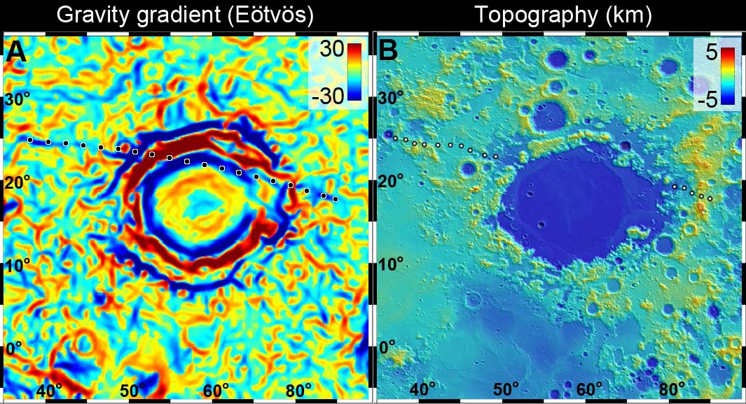
For the first time, the new GRAIL data show us direct evidence for these buried igneous dikes within the lunar crust. One particularly prominent dike occurs near the
Crisium basin, on the eastern near side of the Moon. This dike extends over 1000 km in a quasi-radial direction northwest of the Crisium rim, disappearing beneath the mare lavas of that basin. The fact that it is not clearly aligned with the basin structure suggests that it may predate it; we estimate that Crisium basin is older than 3.9 billion years.
 |
| Newly released GRAIL lunar gravity gradient map centered on Mare Crisium. An otherwise essentially invisible 300 km-long density of mass was detected buried under 3.9 billion year old Crisium (dotted line) [NASA/JPL/MIT]. |
 |
| Small scale topography of the Crisium basin, assembled from laser data points collected by the LOLA instrument aboard the Lunar Reconnaissance Orbiter [NASA/GSFC]. |
 |
| Mare Crisium and vicinity in a monochrome 1240 km-wide field of view from the LROC Wide Angle Camera 100 meter resolution global mosaic [NASA/GSFC/Arizona State University]. |
This long linear feature may have been formed when molten magma from the deep interior of the Moon oozed its way toward the surface, before “freezing” at some intermediate level. Its presence, evident now only by a faint gravity signature (those denser areas “tugging” on the GRAIL satellites “Ebb” and “Flow”), is a tell-tale remnant of its existence deep inside the Moon’s crust.
 |
The highly-detailed GRAIL lunar gravity gradient orthographic map, centered near 60° E meridian (and Mare Crisium, above center). The third of the hemisphere at right is on the Moon's farside. To view the spectacular new animations at their highest-available resolution by visiting the Science Visualization Studio (SVS) at NASA Goddard Space Flight Center, HERE [NASA/JPL/MIT/GSFC/SVS].
|
Many other linear and circular features are evident in
the gravity gradient map produced by GRAIL. Most of these seem to be associated with the large basins of the lunar highlands, the largest impact craters on the Moon. These features both excavate large amounts of crustal material during formation, and serve as topographic lows and structural traps for the accumulation of subsequent erupted lavas. The gradient structures show a complex network of density patterns in the shallow subsurface of the Moon; this area is a morass of crushed rock, fractures, large faults and collapse features. The entire outer portion of the lunar crust has been shattered and broken by an impact barrage of almost unimaginable violence. The crust has since been partly annealed together by heat, re-fractured by additional impacts, intruded by large bodies of molten rock, resurfaced by the eruption of lavas from the deep interior, and finally has had its outermost surface pulverized into a fine powder by the micrometeorite bombardment.
The Moon may look like a silent, dead world but its past (which is Earth’s past) is testament to an early history of extreme violence and chaos. The results from the GRAIL mission are helping us understand this complex story.
Originally published at his Smithsonian Air & Space blog The Once and Future Moon,
Dr. Spudis is a senior staff scientist at the Lunar and Planetary Institute.
The opinions expressed are those of the author and are better informed than average.


1 comment:
A few months ago Zuber reported measurements of higher albedo in Shackleton. But she cautioned they only looked at the micron thick portion of Shackleton's upper layer. From Space.com "'A bigger question is how much water might be buried at depth,' Zuber said, adding that NASA's GRAIL mission will investigate that possibility."
http://www.space.com/16222-moon-water-ice-shackleton-crater.html
I am hoping Zuber will soon talk about what the Grail data tells us about lunar water.
Post a Comment