Thursday, August 15, 2013

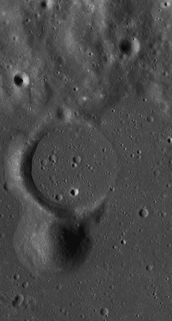
Partially flooded crater rim near Rimae Prinz

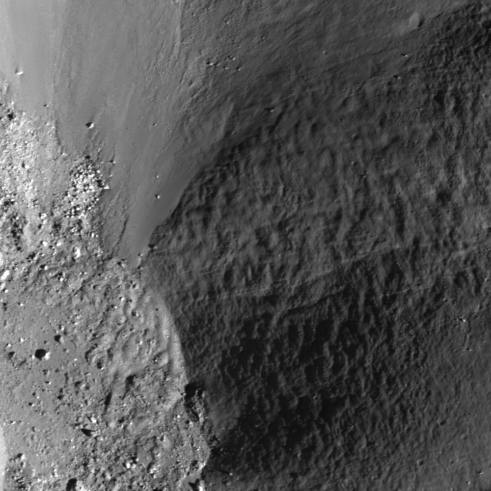
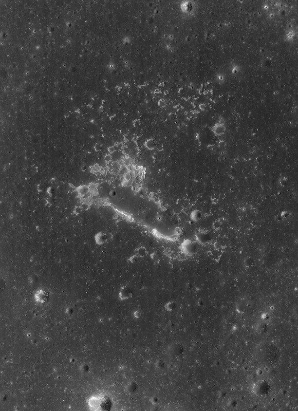
Partially filled crater (1.8 km diameter) located in the Rimae Prinz region, centered at 26.941°N, 316.871°E, LROC Narrow Angle Camera (NAC) observation M1096772216L, LRO orbit 13996, July 12, 2012; 68.58° angle of incidence, 1.36 meters per pixel resolution from 139.45 km [NASA/GSFC/Arizona State University].
Raquel Nuno
LROC News System

Today’s Featured Image is a remnant of an unnamed crater located in the Rimae Prinz region of Oceanus Procellarum. Since geologists use the term crater to describe any hole in the ground, the term crater is further differentiated by its formation mechanism.

Craters on the Moon were formed either by volcanic activity (explosion or collapse) or impacts (asteroids and comets). What clues can be found for this degraded crater that may reveal its formation mechanism?

First check for a raised rim; craters formed by an impact have a raised rim because material is excavated and projected outward and the substrate is uplifted, whereas those formed by volcanic activity typically do not have a raised rim.

topo_M1096772216L-580x1043
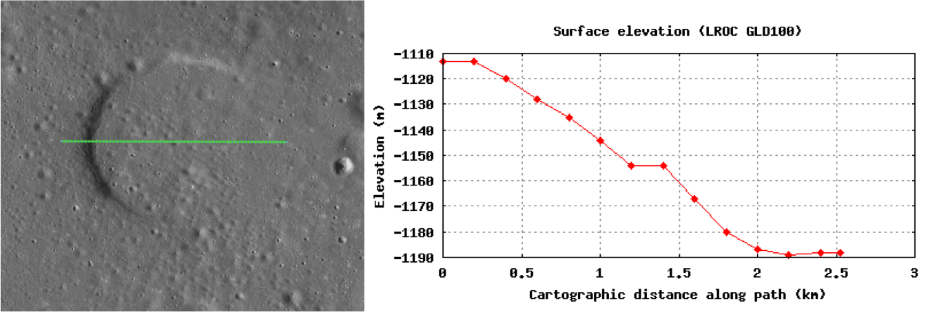
Topography across the flooded crater. The green line is the path that corresponds with the elevation points on the plot. The crater does not have an elevated rim diagnostic of an impact crater. Vertical axis is the elevation value in meters, and the horizontal axis is the distance along the path in kilometers. Elevation values acquired from the LROC GLD100 model [NASA/GSFC/Arizona State University].
The LROC GLD100 model provides a way to inspect the topography along the crater exterior, rim and interior (the green line in the image above). In this case there is no elevated rim, suggestive of a volcanic origin.

Another clue is that the Rimae Prinz region has many known volcanic features such as sinuous rilles and pit craters. The lack of a raised rim, and the surrounding volcanic features, is certainly consistent with a volcano-tectonic collapse origin, later partially flooded with mare basalt from a nearby vent. Or perhaps this crater was a vent itself, and its final eruptions nearly filled it up. A full understanding of how this feature formed may require an on-site investigation.

WAC-fi20130815-580x1000
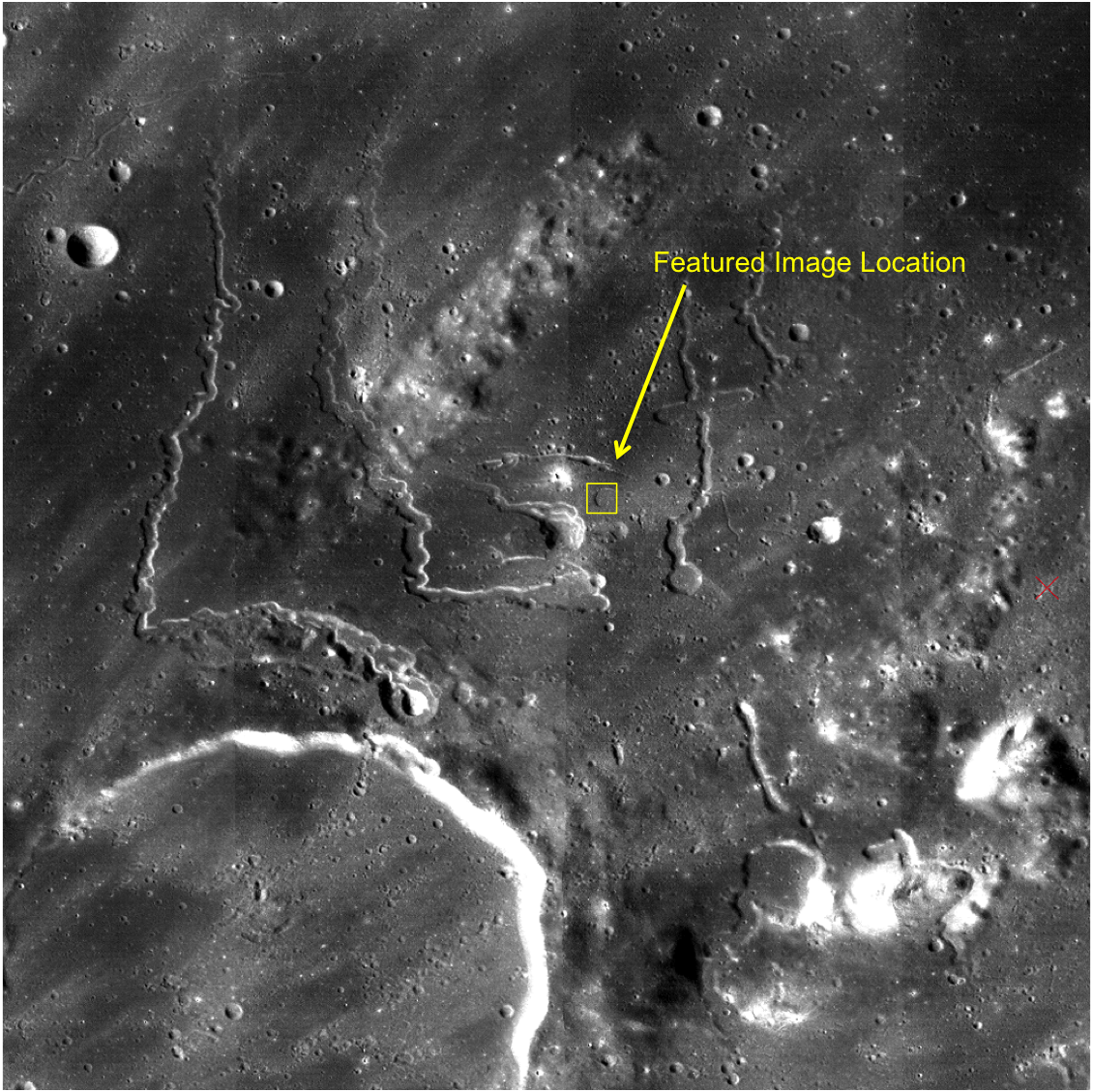
LROC Wide Angle Camera (WAC) context image of the Rimae Prinz region. The crater of interest is marked with an arrow [NASA/GSFC/Arizona State University].
Explore the full NAC HERE, perhaps other clues to the origin of this buried crater can be located nearby.

Related Posts:
Brayley G
Rimae Prinz Region - Constellation Region of Interest
Lunar Kipuka
Rilles as far as the eye can see in Prinz!

Tuesday, August 13, 2013

Follow up on concentricity in Apollo basin

M1097537923LR-NSJ-0567-4199x5676
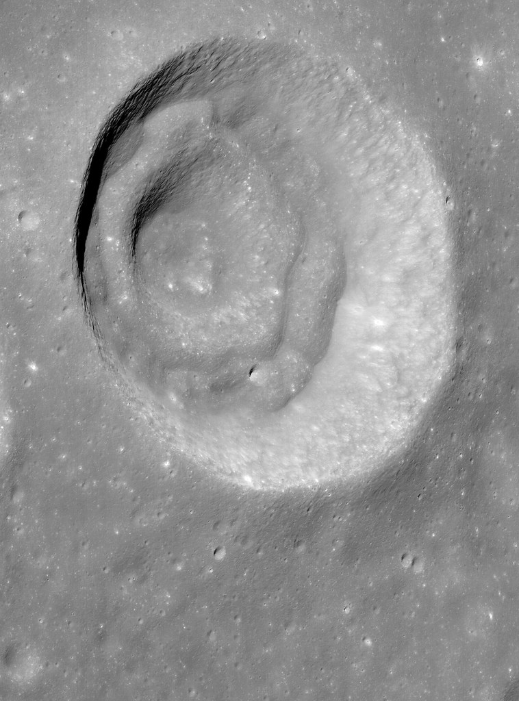
Oblique view of an unnamed but prominent 12 km-wide concentric crater in the Apollo Basin, centered on 30.757°S, 205.931°E. Spacecraft and camera were slewed eastward off nadir 57.74° from 76.2 km over 31°S, 200.62°E, LROC NAC mosaic M1097537923LR, spacecraft orbit 14102, July 21, 2012; resolution roughly 2 km in the original [NASA/GSFC/Arizona State University].
Raquel Nuno
LROC News System

The May 22, 2013 Featured Image showed a portion of an unnamed concentric crater located in the Apollo Basin. Today’s Featured Image is a spectacular oblique (58° from vertical) view of that same crater.

Lunar geologists find craters useful in investigations because they tell so much about the geological history of the Moon. Craters reveal structural properties below their surface and the relative ages of the surfaces where they formed. How can looking at a hole in the ground be so insightful?

Combining imaging with numerical modeling and laboratory experiments, we can test how different structural properties beneath craters affect their shape and size, and even derive information about the direction of the impactor that formed the crater. Crater counting lets us estimate how long a surface has been exposed; more craters indicate an older surface. While insightful, these techniques do not conclusively describe the formation mechanism for all observed crater shapes. That is the case for concentric craters such as the one in today’s post, an unnamed 11.5 km concentric crater located in the Apollo Basin, centered at 30.757°S, 205.923°E. Concentric craters have an inner rim whose formation mechanism is not yet entirely understood, but the concentric mounds may indicate that there is a discontinuity, such as layers with different strengths, in the subsurface excavated by the impact.

LROC WMS (Quick Map) Wide Angle Camera (WAC) mosaic of the 11.5 km concentric crater (center), in context with north and northwestern Apollo basin. [NASA/GSFC/Arizona State University].
Craters are beautiful landscapes depicting the violent impact history of the moon, but are also a reminder of how human ingenuity can unravel the formation mechanisms of geological features on other worlds. As is the case for concentric craters, some of nature’s mysteries require on-site human and robotic investigations to fully understand them.

WAC_CSHADE_O000N2400_064P-2943
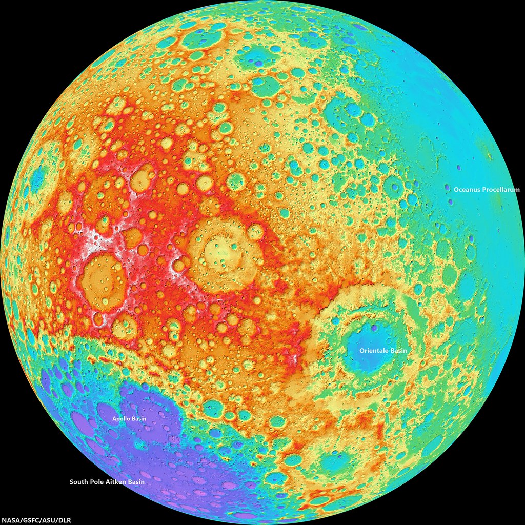
LROC Wide Angle Camera (WAC)-derived global elevation model, hemisphere centered on the equator and 240° east meridian. The Apollo basin, in context inside the rim of 4.26 billion year old South Pole Aitken basin, is at bottom left, site of deep craters - many named in honor of Americans famed for their contributions to lunar exploration - may have excavated samples of the Moon's primeval crust. The Orientale basin, southeast of this view's center, marks the western limb of the Moon's nearside [NASA/GSFC/ASU/DLR],

Investigate and zoom into the full resolution LROC-processed NAC frame, HERE.

Related Posts:
Concentricity in Apollo Basin (May 22, 2013)
Concentric crater (Gruithuisen K - August 4, 2010)
LOLA's Apollo Basin (April 24, 2010)
Apollo Basin: Mare in a Sea of Highlands (March 30, 2010)
"Biggest, deepest crater," an excavation of the hidden, ancient Moon (March 6, 2010)

An unexpected transit

Rafaello Lena, of the GLR Group in Rome passes along this serendipitous interruption of his efforts to record Earth atmosphere-grazing Perseid meteors and perhaps another lunar impact, captured at 1945 UT, Monday, August 12 . An aircraft, and easily "identified flying object," transits the evening Moon. Still 40 hours shy of its Quarter phase, the Moon was 377,200 km away as the terminator swung over central Mare Serenitatis and the Southern Highlands, sunrise over the 1972 landing site of Apollo 16.

Saturday, August 10, 2013

Earthshine

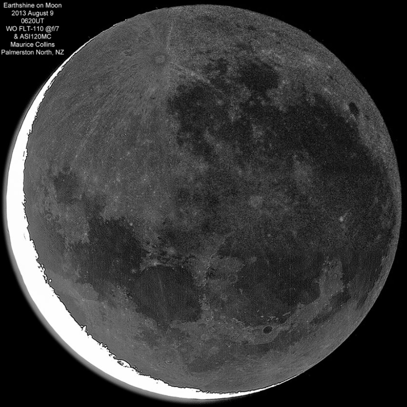
M_Collins-201308090620-earthshine-820
A striking young Moon, only 2.35 days past New, only 5.5 percent illuminated by the Sun, the remainder in earthshine, brought out with exceptional artful detail. The target was 399,215 km away and slowing as its approaches perigee at roughly a kilometers per minute [Maurice Collins/Moon Science].

Friday, August 9, 2013

Small impact on the Moon observed from three locations

lena-manna-sposetti-20130801-580x1200
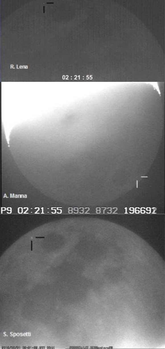
Simultaneous observation of the impact of a "small meteoroid" on the Moon, north of Mare Crisium, 0221:55.7 GMT, 1 August 2013, captured at the same moment by three observers using three telescopes in Switzerland, 10 km apart, and a fourth telescope in Rome 558 km away.  Observations by Raffaello Lena (GLR Group, Rome), using a 130 mm refracting telescope equipped with a Mintron video camera,  Andrea Manna (Cugnasco, Switzerland), with a 200 mm Schmidt Cassegrain equipped with a Watec 120N+ - and by Stefano Sposetti  (Gnosca, Switzerland) using two telescopes, a 150 mm refractor and an 11" Schmidt Cassegrain, each equipped with Watec 902H2  cameras.
Raffaello Lena, of the GLR Group in Rome, has documented the simultaneous observation of the exceedingly transitory flash of an impact on the Moon by three observers, using four telescopes equipped with CCD cameras, from three separate locations.

"On  August 1, 2013 at 02:21:55.7 UT, we observed a small meteoroid impact on the Moon's surface. The kinetic energy transformed into heat caused a brief and intense flash detected simultaniously in telescopes operated by R. Lena, A. Manna and S. Sposetti.

"The simultaneity of the flash observations, at the same position on the lunar surface strongly indicate the flash is unlikely to be mistaken for anything other than an impact."

The event was recorded by Raffaello Lena in Rome Italy, Andrea Manna in Cugnasco, Switzerland, and by Stefano Sposetti in Gnosca, Switzerland. The two observatories in Switzerland were separated by 10 km while Lena in Rome was 558 km from Gnosca.

The meteoroidal lunar impact detected on August, 1, 2013 at 02:21:55.7 UT was simultaneously recorded by  four independent video recordings. The duration of the flash corresponds with 0.08 seconds peaked in a brightness of 8.3 ± 0.7 magnitude. Synchronicity of the documenting images and related files was verified using GPS time inserters (KIWI-OSD) and an Atomic Clock Synchronization protocol.

The coordinates of the flash were determined to 73° (± 4°) East, 27° (± 3°) North, near the crater Seneca C.

"The flash probably corresponds to an α-Capricornids meteor stream, exhibiting favorable geometry at time of impact."

A report of the coordinated observing session is published in Selenology Today, HERE, and an Adobe pdf file with the particular of the event and observing session can be also downloaded HERE.

In addition, Lena reports, "some animations and data, are also presented on my website: http://lunarimpact2.blogspot.it/ ."

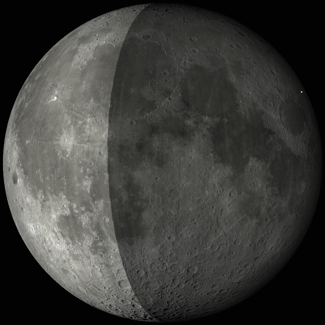
Small impact near Seneca C, 1 August 2013
The phase of the Moon at the time the impact was observed at three locations on Earth, 0221.55 UT, August 1, still a considerably bright 29.7 percent illumination from a Moon, 23.63 Earth-days old in the early predawn. At time of impact, still late July 31 in North America, the Moon was 405,528 km distant [Virtual Moon Atlas v.6].
Related Posts:
Earth's Nightlight (June 26, 2013)
March of Time Paces Changes on the Lunar Surface (May 21, 2013)
Brightest impact recorded by NASA lunar monitoring program, March 17 (May 17, 2013)
LROC team identifies a new lunar crater (July 28, 2010)
Lunar meteor impact observations and the flux of kilogram-sized meteoroids (July 25, 2010)
The Lunar Geminids (December 10, 2009)
Impact Gap in the Moon's Southern Highlands? (May 22, 2008)

Thursday, August 8, 2013

Another look at the effusive dome west of Rima Yangel

M1111791664RL-NSJ-0502-9626x18010
Effusive dome on the southern rim of a  ghost crater situated on the northern shore of Mare Vaporum, in a 11.48 km-wide field of view west of Rima Yangel. LROC NAC mosaic M1111791664LR, LRO orbit 16100, January 2, 2013; 71.03° angle of incidence, 1.19 meters per pixel resolution from 118.91 km [NASA/GSFC/Arizona State University].
Follow-up LROC Narrow Angle Camera (NAC) observation swept up by the orbiter in January and released to the Planetary Data System (PDS) in June. This effusive dome on the north bank of Mare Vaporum was the subject of two extensive posts in February and March.


The mosaic above can be viewed at full and at a variety of medium resolutions, HERE. The dome has bow been imaged from LRO from high and low altitudes, under a range of illumination angles, and many of those observations are referenced in the posts from earlier in the year, linked above.

Convergence

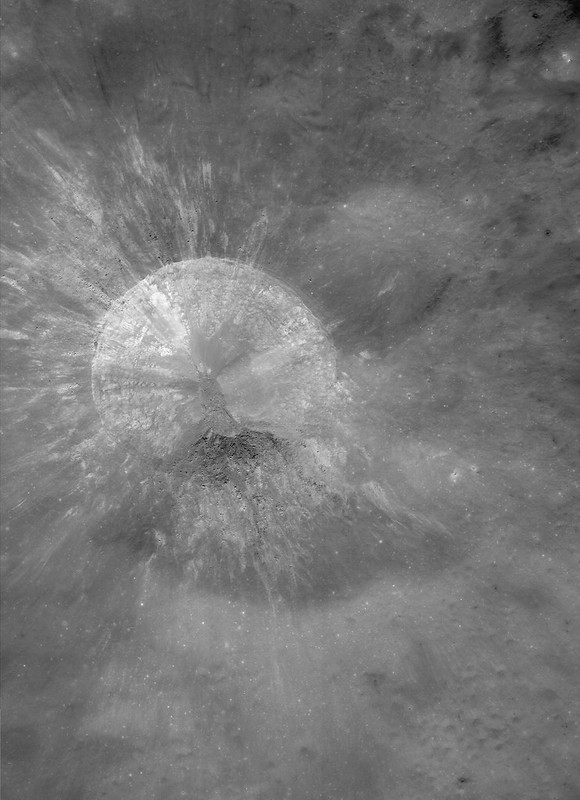
Debris flows converge at the bottom of a youthful crater on the northern frontier of the Moscoviense basin (32.660°S; 143.668°E). LROC Narrow Angle Camera (NAC) frame M1107331321R, spacecraft orbit 15474, November 12, 2012; 62.63° incidence, 1.45 meters resolution from 145.44 km. Field of view approximately 1.4 km across [NASA/GSFC/Arizona State University].
James Ashley
LROC News System

Small crater floors are places where slopes facing different compass directions (azimuths) naturally approach each other.

Steep, recently formed slopes will often produce debris flows that migrate part way or completely to the floor.

The resulting zones of debris convergence can present interesting juxtapositions of coarse and fine deposits with variable light and shadow effects. On an airless body like the Moon, the patterns are frequently striking, and make for studies in artistic composition. The play of sunlight on these surfaces often create some surprising textural patterns and relationships.

Context for the LROC Featured Image within a 7 km field of view [NASA/GSFC/Arizona State University].
This small, unnamed farside crater in the lunar highlands presents a nice example. High-reflectance ejecta in the WAC context image shows it to be the result of a relatively recent impact. Mass wasting events have generated debris flows that have different textures by the time they come to rest at or near the crater floor. Their different slopes produce different angles of illumination and different intensities of reflection.

M187306990RL-NASA/GSFC/Arizona State University
Roughly 9.2 km-wide field of view from LROC NAC mosaic M187306990LR, LRO orbit 12672, March 25, 2012; 31.65° angle of incidence, resolution 105 cm per pixel from 161.18 km over 32.67°E, 143.77°E [NASA/GSFC/Arizona State University].
 Slightly less than 40 km-wide field of view from LROC Wide Angle Camera frame M167260236CE, orbit 9783, 56.55° angle of incidence, 67.4 meters per pixel resolution from 50.4 km [NASA/GSFC/Arizona State University].
There are also examples of impact melt visible in the debris, best seen in the full NAC frame just south of the Featured Image boundary. What clues would you look for to help distinguish impact melt from fine-grained debris flows?

The bright ejecta from the small crater (arrow) contrasts sharply from its far more 'optically mature' surroundings, allowing the eye to easily pick area of interest in small scale albedo maps and this segment of the LROC GLD100 mosaic showing the crater's location with respect to Mare Moscoviense [NASA/GSFC/Arizona State University].
Explore additional details in the full NAC frame HERE.

Similar Featured Image posts have been presented as "Diversity," "Complicated Crater," and "Rubble Pile on Fresh Crater Floor."

Project Morpheus tether test #28


Morpheus Bravo vehicle executed a successful tether test on August 7, 2013 at Johnson Space Center. The combined Morpheus/JPL team met all test objectives including engine ignition, ascent, a 3 meter lateral translation over simulated Mars soil provided by JPL to help them with a plume study, 40 seconds of hover at the apex, and a slant descent to "landing" using free flight guidance. The entire flight duration was ~80 seconds. All though the Mars soil simulant is not typical for Morpheus test fires, it sure made for a spectacular show.

Project Morpheus Tether Test 21 (May 24, 2013)
Morpheus Unit B first fully integrated hot fire test (May 6, 2013)
Morpheus and ALHAT teams, still hard at work (February 11, 2013)
Morpheus employs ALHAT in teather test #16 (June 13, 2012)
Project Morpheus lander - Soft Abort Test (May 11, 2012)
Morpheus Tether Test #10 (April 9, 2012)
Morpheus Tether Test #8 (March 14, 2012)
Project Morpheus methane Hot Fire Test #5 (February 29, 2012)
Morpheus lander in tethered flight tests (May 7, 2011)  

Tuesday, August 6, 2013

Symmetry in Asymmetry

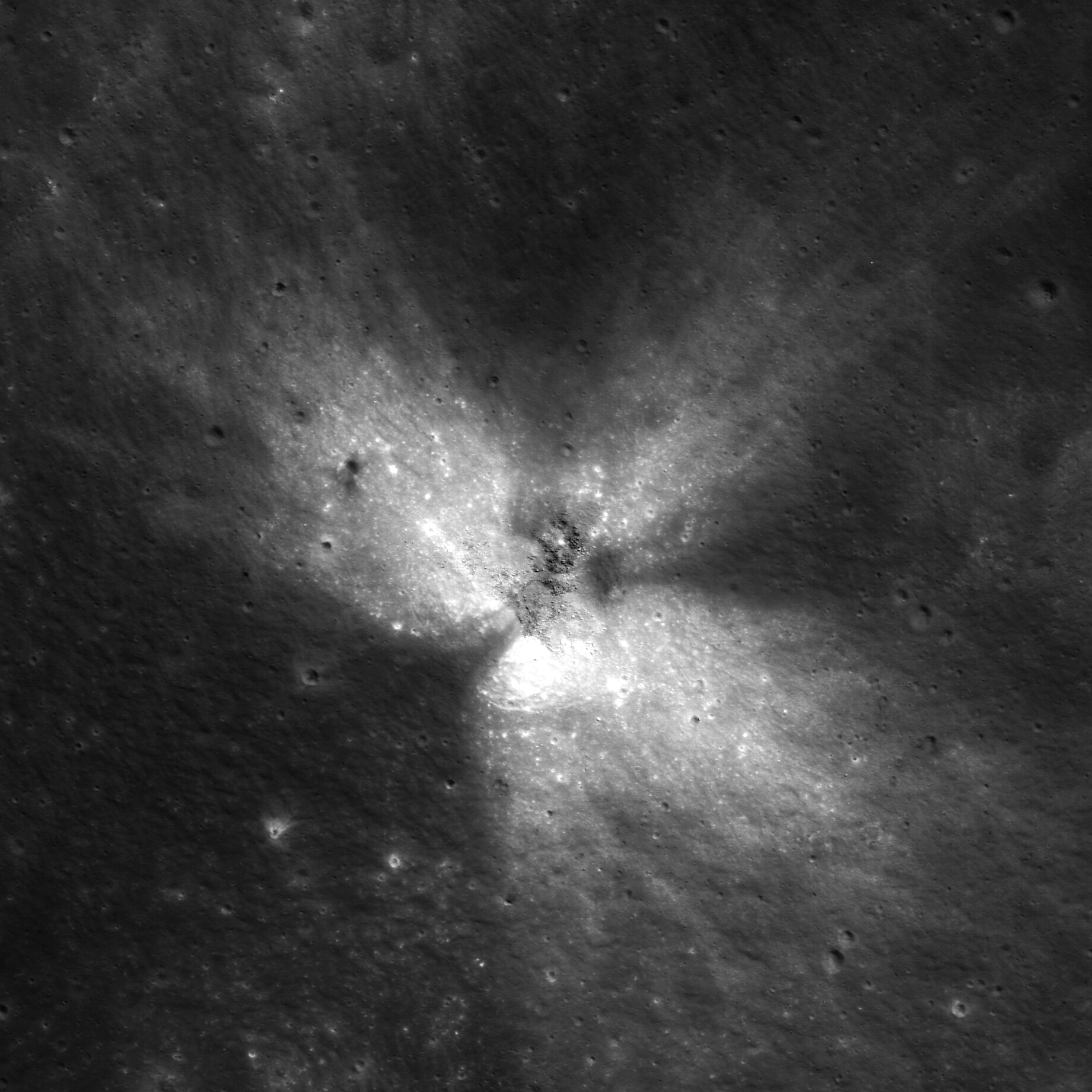
A beautiful example of an asymmetric impact feature (27.674°S; 125.465°E). LROC Narrow Angle Camera (NAC) frame M110771566R, LRO orbit 1458, October 21, 2009; illumination angle of incidence 31.51° from the northeast, image field of view roughly 1.2 km across, resolution 63 cm per pixel from 60.63 km [NASA/GSFC/Arizona State University].
James Ashley
LROC News System

While the total energy of an impact depends on the projectile velocity and mass, low-angle (oblique) impacts can distribute this energy in ways that differ from that of a higher angle trajectory.

By definition oblique impacts strike at an angle of 15° or less, producing something more akin to a 'glancing blow' rather than a 'hard smack,' and often result in asymmetrical 'wing-shaped' ejecta patterns.

Based on the ejecta surrounding this small feature in Neujmin crater in the lunar farside highlands, a case can be made for a southwestern approach from the impacting object. Debris was tossed in the down-track direction and splayed at right angles to the flight path on either side. The ejecta is actually quite symmetrical with respect to this flight axis (axial symmetry). The notion of asymmetry really applies to rotational symmetry in the case of many oblique impacts.

One of three dark halo craters (DHC) on the floor of Deutsch crater and recently proposed as one of many newly surveyed potential landing sites picked to fulfill high-priority science goals. A 4-km-wide field of view from LROC NAC observation M185169501R,  spacecraft orbit 12373, February 29, 2012; angle of incidence 29.7° resolution 1.46 meters per pixel from 148.15 km [NASA/GSFC/Arizona State University].
Smaller impacts created markings on the ejecta blanket, and these events excavated through the high-reflectance ejecta bringing up lower reflectance, mature materials -- producing dark-haloed craters. These small dark halo craters likely formed seconds after the high reflectance material was emplaced as slower, larger pieces of ejecta landed.

LROC Wide Angle Camera (WAC) GLD100 mosaic of the ancient, possibly highly "disrupted" terrain in and around Neujmin crater, southeast of the more distinctive farside landmark Tsiolkovskiy crater, presented as context for the 'winged' crater in the LROC Featured Image, released August 6, 2013. It's location is marked by the arrow [NASA/GSFC/Arizona State University].

The full NAC frame can be explored HERE.

Additional examples of oblique impacts are available in the Featured Image browse gallery, including "Not Your Average Crater," "A Tiny, Glancing Blow," and "Crash or Coincidence?"

Wednesday, July 31, 2013

Melted Moon

Click for full resolution LROC mosaic
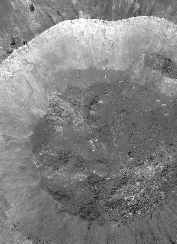
The fresh lunar crater Giordano Bruno -a wealth of fascinating landforms to study. (click image for full resolution view, or HERE for a wider, medium resolution field of view showing the entire crater) [NASA/GSFC/Arizona State University].
Paul D. Spudis
The Once and Future Moon
Smithsonian Air & Space


Prior to the Space Age, one of the longest running controversies in lunar science was over the origin of the Moon’s craters.  Two camps emerged, one favoring an internal (volcanic) origin and the other an external (impact by solid bodies) origin.  Although this debate was finally resolved in favor of impact, the argument was long and vehement, reigniting at one point during the flight of the last of the robotic precursor probes to the Moon, prior to the Apollo landings.  Although the basic physics of impact were well understood by the mid-1960s, this newest argument centered around high-resolution pictures obtained by Lunar Orbiter 5 (1967) of the fresh (and therefore young) crater Tycho.  These spectacular images showed a multitude of flows, smooth ponds, and fluid rock, seemingly draped over hills and hummocks (like a chocolate shell coating over a scoop of ice cream).

An asteroid possesses an enormous amount of kinetic energy when it strikes a planetary body at very high speeds.  On contact, the asteroid vaporizes and the surface target rocks are intensely compressed.   After the shock wave has passed, these rocks decompress and the release of this energy totally melts part of the crustal target.  This material is said to be shock melted, with the resulting liquid called impact melt.  Impact melt was first described from craters on the Earth, particularly some of the very large impact craters found on the ancient Canadian Shield.  These rocks superficially resemble some volcanic rocks, having both fine-grained textures and partly melted inclusions.  But unlike volcanic rocks, they have high concentrations of siderophile (“iron-loving”) elements, such as iridium.  These elements are extremely rare in the Earth’s crust, but are more abundant in meteorites and asteroids.  It is thought that they are added to the melt from the incoming projectile.

The newest chapter in the argument about the origin of craters came about because some landforms around Tycho look similar to small-scale volcanic features on Earth.  The idea proposed was that the craters had been formed by impact, with those collisions triggering volcanic activity and producing multiple episodes of eruption at Tycho and other craters.  At first glance, such a scenario seems plausible.  After all, impact is a catastrophic event and one can imagine churning seas of subsurface liquid rock, released suddenly through the creation of fractures deep in the crust.  But the Moon’s interior is relatively cool.  If interior melt exists, it is at a level much too deep for any reasonably sized impact to tap.  But these amazing landforms needed to be explained.  What might they represent?

We found abundant physical and chemical evidence for impact (including shock-melted rocks) by studying the Apollo samples.  They appear similar to volcanic lava, with inclusions, melt textures and even vesicles (holes), comparable to the ones produced by magmatic volatiles coming out of solution in basaltic lavas on Earth.  Although it took a bit of study (and many more arguments) to establish their origin, shock melting became recognized as an important lunar (and Earth) impact process.
M160029952LR-109-1160x1600
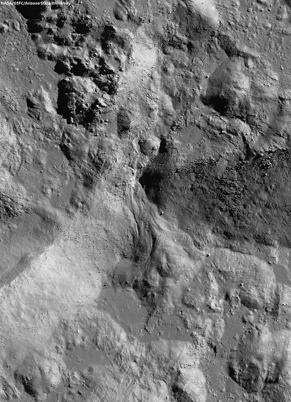
Breech in the northwest rim of Tycho connects to the spectacular melt ponds inside out outside of the 109 million year old landmark crater. Illustration originally from "Landing Site at Tycho North," March 20, 2013 [NASA/GSFC/Arizona State University].
The images of the flows and ponds seen around Tycho and other fresh lunar craters led to a better understanding of how these rocks formed.  Although we knew about impact melting from the study of Earth’s craters (and had found evidence of the same in lunar samples), some researchers still weren’t convinced that we were seeing flows of liquid impact melt on the Moon.  The leading non-volcanic alternative was that these features were flows of dry, fine-grained granular debris.  In part, this interpretation proceeded from the observation that the thermal signatures of some of these melt-like flows suggested the presence of fine debris rather than bare, jagged rock.  Yet other data, such as radar backscatter, suggested that rough surfaces were common, while extremely high-resolution images showed abundant blocky craters on the surfaces of the flows, suggesting they were composed of solidified rock.
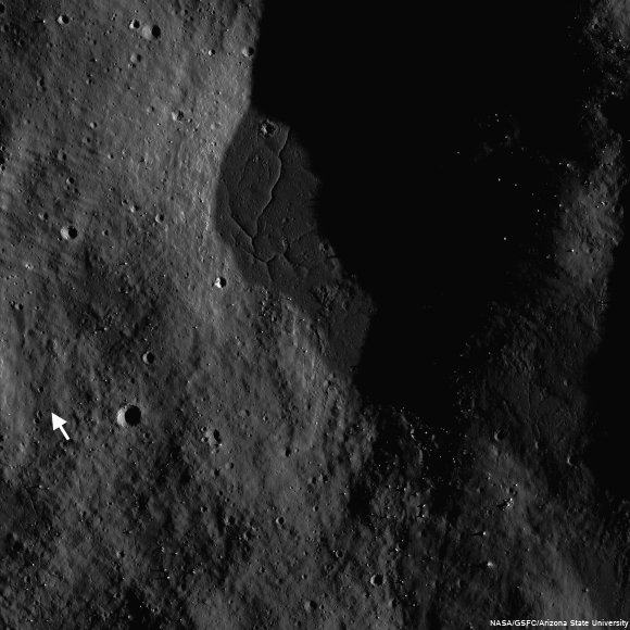
Landing site of Surveyor 7 (arrow) in relation to it's hoped for target, the kilometer-sized impact melt pond immediately to the northeast, part of the spectacular melt throughout the vicinity of Tycho [NASA/GSFC/Arizona State University].
Images from the robotic Surveyor 7 (1968) spacecraft, which landed on the rim of Tycho, revealed the thinnest regolith (soil) covering of any site on the Moon.  Visible in the surface panoramas were flow features covering the distant hills.  It took a great deal of painstaking, detailed work to establish that these flows and ponds were composed of liquid rock, created simultaneously with their host crater and likely originated by impact melting and subsequent solidification.

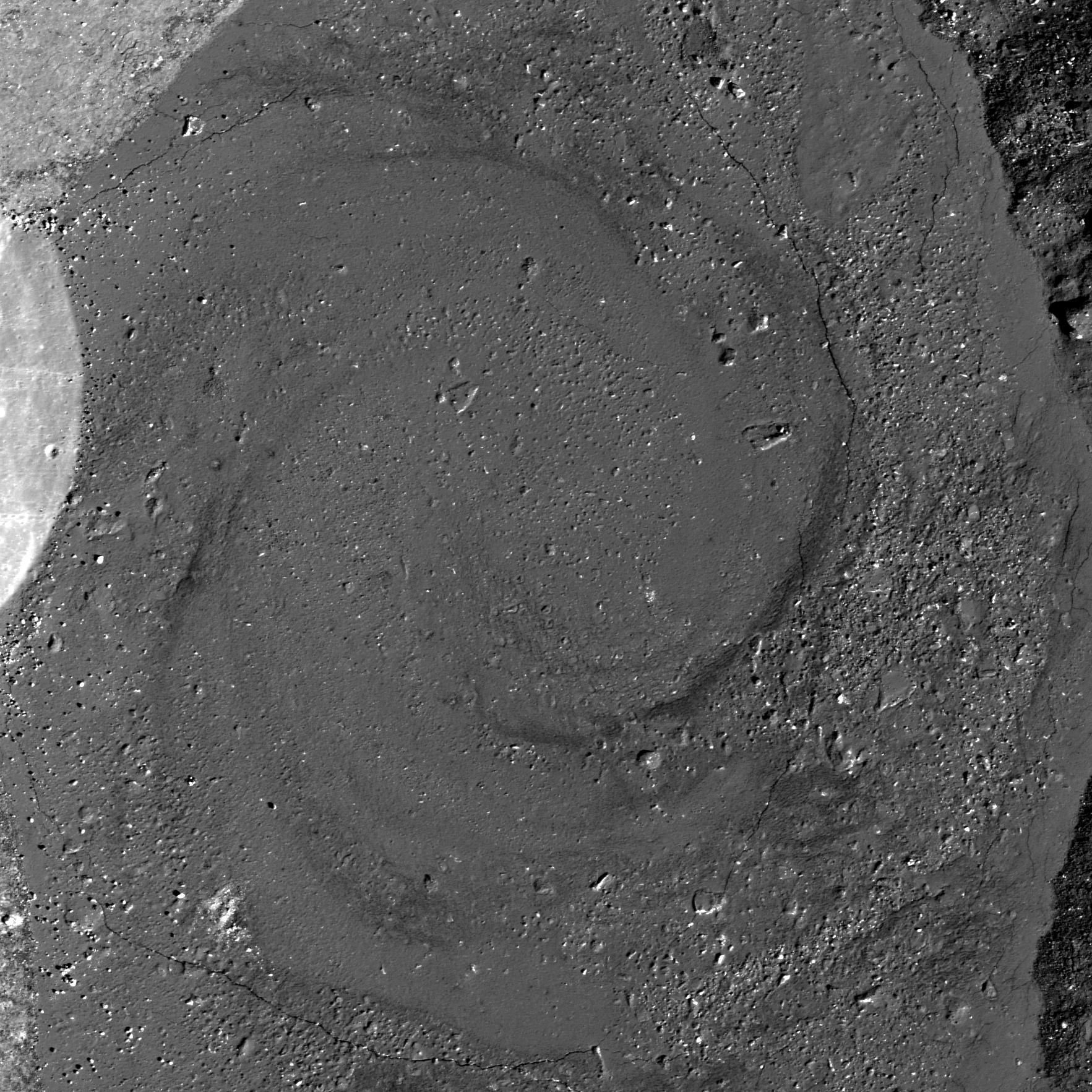
For the last several years, NASA’s Lunar Reconnaissance Orbiter (LRO) has been sending us new and astonishing views of the Moon’s impact melt flows.  Whereas fresh craters like Tycho, Aristarchus and Copernicus were well known from previous Lunar Orbiter frames, far side craters like the spectacular Giordano Bruno can now be seen with incredible clarity.  G. Bruno is one of the very youngest craters on the Moon.  A low density of craters overlying G. Bruno suggests an age of less than a couple million years (extremely young on a planet where most features count years in the billions).  It is an astonishing spectacle of melt shapes and deposits (cracked floors, pools, flow festoons and lobes); the crater floor has an amazing whirlpool of solidified melt. All these features indicate that after the crater formed, the impact melt was mobile, flowing and collecting, and ponding in low areas.

Impact melt forms a swirled feature in Giordano Bruno crater. Field of view 1 kilometer. From LROC Narrow Angle Camera (NAC) observation M143947267L LRO orbit 6347, November 9, 2010; 53.08° angle of incidence, 57 centimeters per pixel resolution from 54.50 km. Illustration from "Giordano Bruno Whorl," June 8, 2013 [NASA/GSFC/Arizona State University].
Impact melts are of great interest to geologists.  Unlike other crater ejecta, the radiometric clocks of impact melts are completely re-set by the melting.  Thus, if a sample can be obtained first-hand, directly from an observed flow or pool of melt around a host crater, the age of that rock specifically and unambiguously dates the impact event.  Unfortunately, we did not visit such deposits during the Apollo explorations.  What we do have are loose samples of lunar impact melt but not their scientifically important corresponding geological context.  It is for this reason that the age and sequence of early lunar history is so contentious – we must make educated guesses about where certain melt rocks come from.  If we get the context wrong, then our conclusions about the history of the Moon are incorrect.

Increased understanding of the generation and deposition of impact melt comes from the new images obtained by the LRO camera of the geologic setting of impact melts.  Future sample return missions to the Moon can be directed to landing sites that will provide us with samples of clear geological context (that they were from that area and not just flung there by an impact occurring elsewhere on the lunar surface).  As features age on the Moon, subsequent geologic events (such as superposition of new units) bury or erase the original event making the context less clear.  This problem is particularly acute for the oldest features on the Moon (multi-ring impact basins).  By studying the geology of the freshest lunar features (such as Tycho and other fresh craters), we understand how the older impact features looked immediately after their formation.  Thus, they serve as a guide to the interpretation of the older features.  On the Moon, as on the Earth, as Charles Lyell, the 19th century author of the classic Principles of Geology aptly put it:  The present is the key to the past.

Collection of spectacular impact melt features from LRO:
Giordano Bruno high-resolution full view
G. Bruno sunset
G. Bruno flows
G. Bruno cracked melts
Tycho oblique
Tycho floor
Tycho river of rock

Originally published July 31, 2013 at his Smithsonian Air & Space blog The Once and Future Moon, Dr. Spudis is a senior staff scientist at the Lunar and Planetary Institute. The opinions expressed are those of the author but are better informed than average. 

ESA prepares for LADEE

LADEE approaches lunar orbit
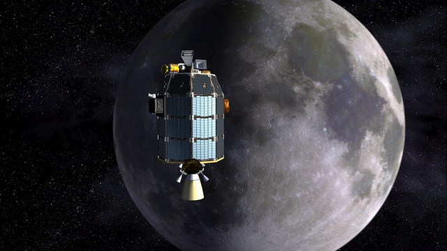
Artist's view of NASA's Lunar Atmosphere and Dust Environment Explorer (LADEE) observatory as it approaches lunar orbit [NASA].
An advanced laser system offering vastly faster data speeds is now ready for linking with spacecraft beyond our planet following a series of crucial ground tests. Later this year, ESA’s observatory in Spain will use the laser to communicate with a NASA Moon orbiter.

The laboratory testing paves the way for a live space demonstration in October, once NASA’s Lunar Atmosphere and Dust Environment Explorer – LADEE – begins orbiting the Moon.

LADEE carries a terminal that can transmit and receive pulses of laser light. ESA’s Optical Ground Station on Tenerife will be upgraded with a complementary unit and, together with two US ground terminals, will relay data at unprecedented rates using infrared light beams at a wavelength similar to that used in fiber-optic cables on Earth.

“The testing went as planned, and while we identified a number of issues, we’ll be ready for LADEE’s mid-September launch,” says Zoran Sodnik, manager for ESA’s Lunar Optical Communication Link project.

“Our ground station will join two NASA stations communicating with the LADEE Moon mission, and we aim to demonstrate the readiness of optical communication for future missions to Mars or anywhere else in the Solar System.”

Read the illustrated ESA article, HERE.

Laser from Optical Ground Station on Tenerife
ESA's Optical Ground Station (OGS) is 2400 meter above sea level on the volcanic island of Tenerife, in the Canary Islands. Visible green laser beams are used for stabilizing the sending and receiving telescopes on Tenerife and neighboring La Palma. The OGS facility is utilized for extensive experiments with entangled photons, quantum communication and teleportation. OGS is also used for standard laser communication with satellites, tracking space debris and finding new asteroids. The image above includes Tenerife's Teide volcano with the Milky Way in the background [ESA/IQOQI Vienna, Austrian Academy of Sciences].

Tuesday, July 30, 2013

Orientale Sculpture

An oblique view of ejecta over 400 km south of the Orientale basin rim, a scene approximately 5 km across, centered at 51.8°S, 264.8°E, LROC Narrow Angle Camera (NAC) mosaic M1127819355LR, LRO orbit 18355, July 7, 2013; native resolution 1.9 meters per pixel [NASA/GSFC/Arizona State University].
Brett Denevi
LROC News System

Today's featured image is located near the center of the ancient 600-km Mendel-Rydberg basin. Its degraded state means Mendel-Rydberg's presence is not obvious in the WAC context image below (in fact, its existence was only confirmed with Clementine (1994) topography data), but its western rim is near the crater Mendel, and Rydberg and Guthnick craters are near the center of the basin.

However, it was not the Mendel-Rydberg impact that was responsible for the ups and downs in the hummocky deposits seen in today's Featured Image, but the Orientale impact event, hundreds of kilometers away to the north.

Ejecta from impact basins is both erosional, gouging out long valleys and leaving strings of large secondary craters (along the arrows in the image below), and depositional, blanketing even distant terrain with material excavated from the impact site. Basin ejecta plays such a large role shaping the lunar surface that these ups and downs are often referred to as "basin sculpture," and the ejecta from Orientale certainly sculpted the terrain in today's image.

LROC Wide Angle Camera (WAC) mosaic context views of the southern Orientale region. The blue box in the image at bottom shows the field of view at top, where a yellow box shows the approximate field of view shown in the LROC Featured Image. Click to enlarge [NASA/GSFC/Arizona State University].
The hummocky deposits that cover low-lying areas in the top image, and the image below, are likely ejecta from the Orientale basin. These low-lying regions may have once been exposures of smooth mare basalt, some of which is still exposed on the surface in nearby regions, but are now hidden under a blanket of debris from Orientale. Buried volcanic deposits such as these are known as "cryptomare" and tracking down the locations of these ancient sites of volcanic activity is key for understanding the extent of early volcanism on the Moon.

A wider (and reduced-resolution) view of the LROC NAC mosaic from which the LROC Featured Image within the Mendel-Rydberg basin was cropped. LROC NAC M1127819355LR [NASA/GSFC/Arizona State University].
You may also note that the hills in the southern portion (right side) of the image above have a lumpy texture, also visible in the WAC context image. This is also likely due to Orientale's influence - the result of a massive ground hugging flow of ejecta that piled up on the sloped terrain. This oblique view of the region gives a great perspective on its complex history that would have been compelling enough with just the ancient Mendel-Rydberg basin and early lunar volcanism, but the spectacular basin ejecta flows captured here are just icing on the cake (so to speak).

Click HERE to see the full-resolution view.

Related LROC Featured Images:
Amazing Orientale Peaks and Valleys
Regolith Patterns in Mendel-Rydberg
Window to the Farside Mantle
Two-toned Impact Crater in Balmer Basin: A reflection of the Target?
Dark Craters on a Bright Ejecta Blanket

Thursday, July 25, 2013

Snapshots from the Moon and Cislunar Space

Apollo 17 commander Eugene Cernan (UR, LR), CM pilot Ron Evans (UL, LR) and LM pilot and geologist Harrison "Jack" Schmitt (LL) relaxing in the Apollo 17 Command Module America after Cernan and Schmitt returned from three days of exploring the magnificent Taurus Littrow valley, the last manned expedition to the lunar surface 40 years ago, December 1972 [NASA/ Arizona State University].
Mark Robinson
Principal Investigator
Lunar Reconnaissance Orbiter Camera
Arizona State University

This year, we commemorate the forty-fourth anniversary of the first human lunar landing. By now, the whole world is very familiar with the high-quality Hasselblad snapshots taken by the Apollo astronauts during their voyages. However, 35-mm cameras were also carried on some of the Apollo missions for both surface and orbital imaging. Most of the surface 35-mm images are extreme closeups of the lunar regolith from the Apollo Lunar Surface Closeup Camera (ALSCC; Apollo 11, 12, 14); sometimes called the Gold Camera after its Principal Investigator Thomas Gold.

The Nikon camera used on board the Apollo Command Module was equipped with a 55-mm lens and was loaded with either black-and-white or color film. During Apollo missions 16 and 17, black-and-white film was used for dim-light photography of astronomical phenomena and lunar surface targets illuminated by Earthshine. During Apollo 17, color film was used for documenting various activities in the Command Module.

The 35-mm frames are now scanned as part of a joint project between Arizona State University and the NASA Johnson Space Center to scan all of the original Apollo flight films.

Boot print anaglyph - Stereo anaglyph (get out your red-blue stereo glasses!) AS14-77-10369a,b from the ALSCC showing extreme detail of an astronaut bootprint in the fine-grained lunar regolith. The original field of view is about 3 inches on a side [NASA/Arizona State University].
The Apollo 17 crew seems to have had the most fun with the 35-mm format! Gene Cernan, Ron Evans and Jack Schmitt snapped quite a few spectacular black-and-white images showing the view out of the window of their Command Module, the America. Some of these images are a bit grainy, resulting in a very different feeling than the crisp Hasselblad photographs. They also took numerous color candid shots inside the Command Module. It is rare to see such carefree moments during the Apollo missions, but you can feel the relief and happiness after the astronauts so successfully fulfilled their surface mission!

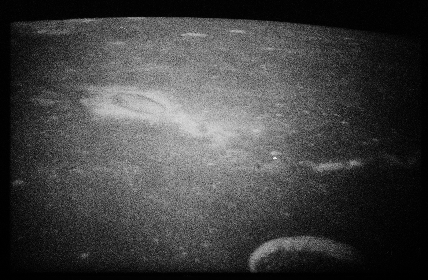
Reiner Gamma illuminated solely by earthshine (35-mm Apollo 17) - Reiner Gamma, one of the enigmatic lunar swirls; their origin is related to localized magnetic fields within the crust AS17-158-23894 [NASA/Arizona State University].
Many of the window shots present an oblique view across lesser known regions of the Moon. The terminator (boundary between night and day) scenes are always captivating. Look closely at the scene below; near the center is a shallow-sloped scallop-shaped rise. Just below and to the right are two other smaller rises - perhaps these are low shield volcanoes? You can dig deeper by visiting the LROC QuickMap browser and see if the NAC images can elucidate what is seen here (Natasha crater is at 19.973°N, 328.843°E).

Mare Imbrium meets Mare Procellarum (Apollo 17 35-mm frame) a complex region composed of nearly buried peaks that are part of the Imbrium rim, impact craters, and volcanic forms. Annotated AS17-160-23992 [NASA/Arizona State University].
Relive the incredible adventure that was Apollo, browse the Apollo 35-mm archive and the rest of the Apollo scans (Metric, Pans; Hasselblads to follow next year). While browsing, map out your own next mission to the Moon! The hard part is figuring out where to visit next. Enjoy!

Related Posts:
Project Mercury Photography Now Online
Project Gemini Comes to Life
Reiner Gamma Constellation Region of Interest
Mare Ingenii Swirls

Tuesday, July 23, 2013

The View Inside a Tilted Crater

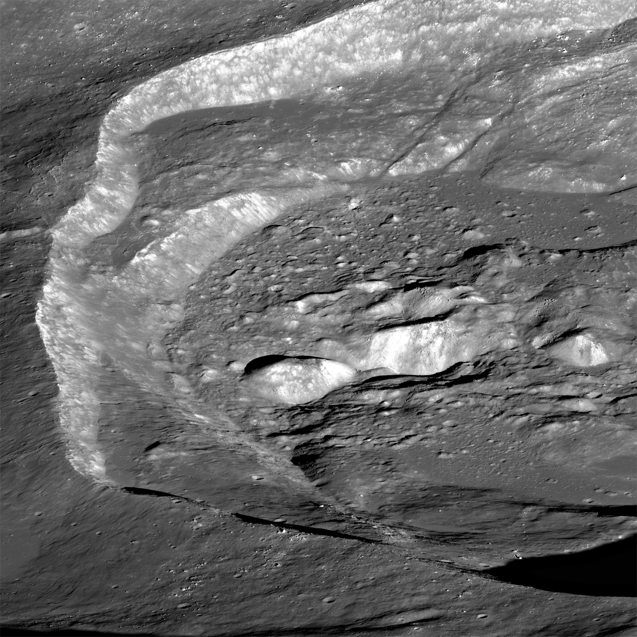
Oblique view of the chaotic interior of 30-km Wiener F crater. LROC Narrow Angle Camera (NAC) mosaic M1113262343LR; LRO orbit 16307, January 19, 2013, spacecraft and camera slewed 52° west from 160.39 km over 41.84°N, 140.28°E, subsampled from a scaled 2.78 meter per pixel resolution. Scene width approximately 13 kilometers from left to right, centered at 41.1°N, 150.0°E. [NASA/GSFC/Arizona State University].
Brett Denevi
LROC News System

Impact melt is commonly found in and around fresh lunar craters and can be spotted as ponds, flows, and ejecta.

This oblique view of the farside crater Wiener F highlights one of the more spectacular examples of what happens to the melt when a crater forms on a slope.

In the image above, you have a great perspective view of the chaotic crater interior, where material slumping into the crater interacted with the fluid melt, creating rough, hummocky mixtures in some regions and smoother pools of melt in others. But what is really interesting about this crater becomes clear when you zoom out to the full width of the image, below.

Thumbnail view of LROC NAC mosaic M1113262343LR, looking from west to east into Wiener F crater. For the full-resolution, zoomable view click HERE [NASA/GSFC/Arizona State University].
Wiener F formed atop a larger, older crater, so its northern rim, on the left in the picture above, ended up substantially lower than the southern rim. A profile across the crater, taken from the GLD100, shows the northern rim of the crater is over 2 km lower in elevation than the southern rim!

A profile from south to north across crater Wiener F, taken from LROC WAC-derived topography data [NASA/GSFC/Arizona State University].
So tilting the crater like this is like tilting a glass of water - it spills. In this case, the hot impact melt that would normally stay within the crater poured out, spilling over the northern rim and pooling outside the crater. Click on the image below to see this spectacular flood. You can find individual flows and places where the melt was still moving even as a crust of hard rock formed on top, resulting in cracks and wrinkles in the top layer.
View of the impact melt that escaped Wiener F, pooling outside the northern crater rim. Image subsampled from the original resolution [NASA/GSFC/Arizona State University].
Impact melt is a favorite target for LROC imaging because of its often complicated and bizarre features, and because of what it tells us about the impact process. The volume of melt can give clues as to how fast an impactor hit the surface (higher velocities mean higher shock pressures and more heat to melt rock), at what angle it impacted (melt is often thrown downrange of an impact), and how long ago the impact occurred (by observing how well preserved the melt morphology is, or by age-dating a sample of melt). Impact melt can also give insights into how portions of the crater moved and settled as the crater formed (for example, how did melt get up HERE?).

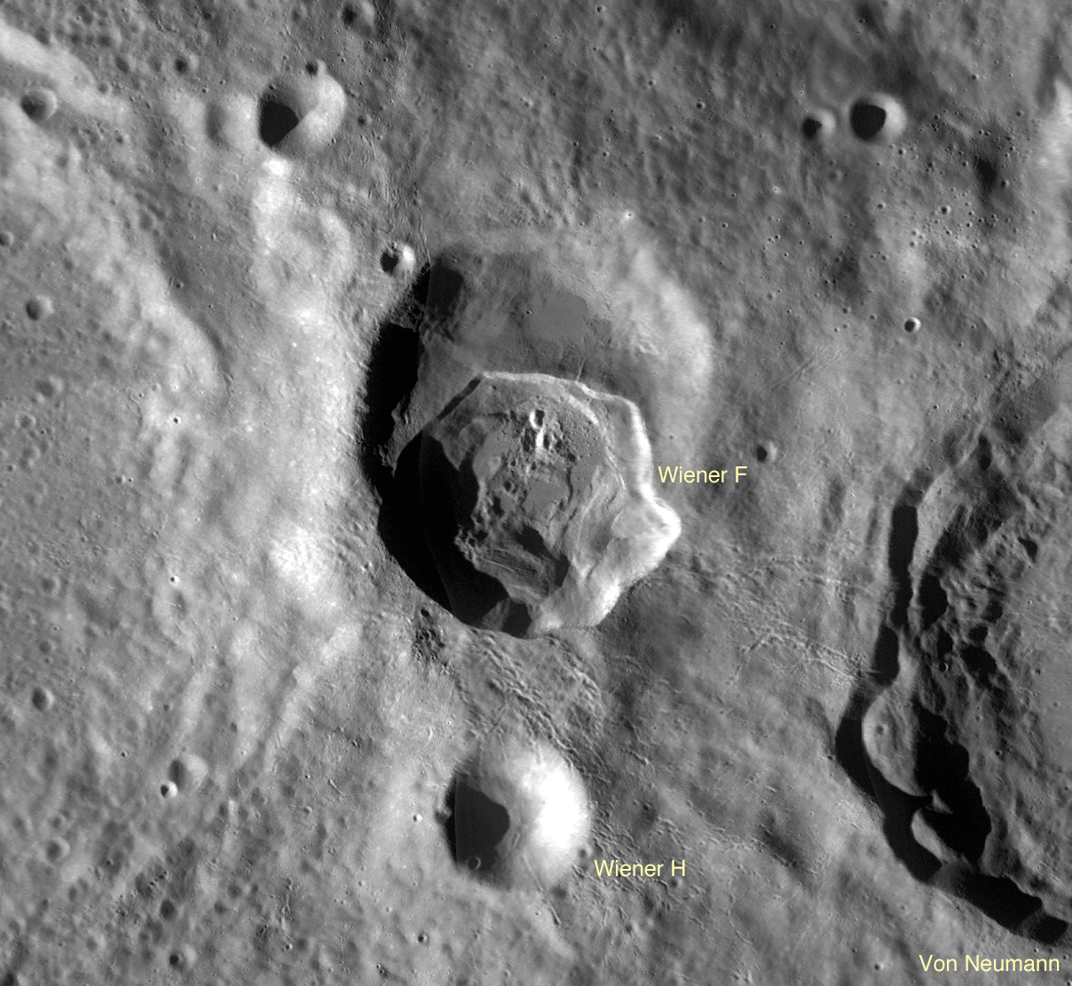
LROC Wide Angle Camera (WAC) contextual view of Wiener F crater, nested in the Farside Highlands [NASA/GSFC/Arizona State University].
Wiener F is another piece of that puzzle, showing what a dynamic environment an impact crater is shortly after formation. Click HERE for the full-resolution view of Wiener F.
Other Spectacular
Impact Melt Favorites:
Rumker E Impact Melt
Dynamics of Molten Rock
La Pérouse A Impact Melt
Rippled Pond
Breached Levee
Secondary Melt on the rim of Wiener F
Getting cracked in Wiener F
Giordano Bruno Whorl

Small-Scale Volcanism on the Lunar Mare

LROCWAC-small-shield-volcanism-1314
"Small Shield Volcanism on the Lunar Mare," (figure 1.) EPSC 2013-875 Plescia, Robinson & Joliff. Constructs in Mare Tranquillitatis. a: low-relief, low-slope with central crater; b "pancake-shaped"; c and d': hummocky, steep-sided , gc: ghost crater. LROC Wide Angle Camera high-angle incident mosaic, centered near 7.5°N, 37.5°E [NASA/GSFC/Arizona State University] .
Plescia, Robinson & Jolliff
Johns Hopkins APL
Arizona State University
Washington University of St. Louis


"Small shield volcanoes having low relief and gentle slopes are scattered across the lunar mare. These features represent the terminal phases of mare volcanism and are formed by short-duration, low-volume eruptions. Composition and eruption dynamics may have varied as the morphology and color of the shields vary. There appears to be regional correlations of morphometric properties indicating larger-scale organization of the eruptions.

"Data from LRO and other missions now provide the ability to characterize each dome in terms of areal extent, topography, morphology, and color properties in unprecedented detail allowing for an analysis of their origin.


"Here, a subset of the domes are interpreted to represent a volcanic style characterized by small volume eruptions that built low-relief constructs (Fig. 1). This style of volcanism has been termed plains volcanism [14] and is common in the Tharsis region."

Small Shield Volcanism on the Lunar Mare, European Planetary Science Conference 2013, Vol. 8, #875; J.B. Plescia, Johns Hopkins University Applied Science Laboratory; M.S. Robinson, Arizona State University; B. Jolliff, Washington University, St. Louis

M190351657L-NSJ-0503-6509x8978
Small-scale shield volcanic vent structure ("d." in WAC mosaic above) south of Rupes Cauchy in Mare Tranquillitatis, near 7.5°N, 37.5°E; Vent strongly presents features resembling those of the Ina structure. 6.2 km-wide field of view from LROC NAC mosaic M190351657LR, LRO orbit 13098, April 29, 2012; 41.95° angle of incidence, resolution 0.95 meters per pixel from 113.33 km. Full-size versions HERE [NASA/GSFC/Arizona State University].