Showing posts with label Apollo Basin. Show all posts

Tuesday, August 13, 2013

Follow up on concentricity in Apollo basin

M1097537923LR-NSJ-0567-4199x5676
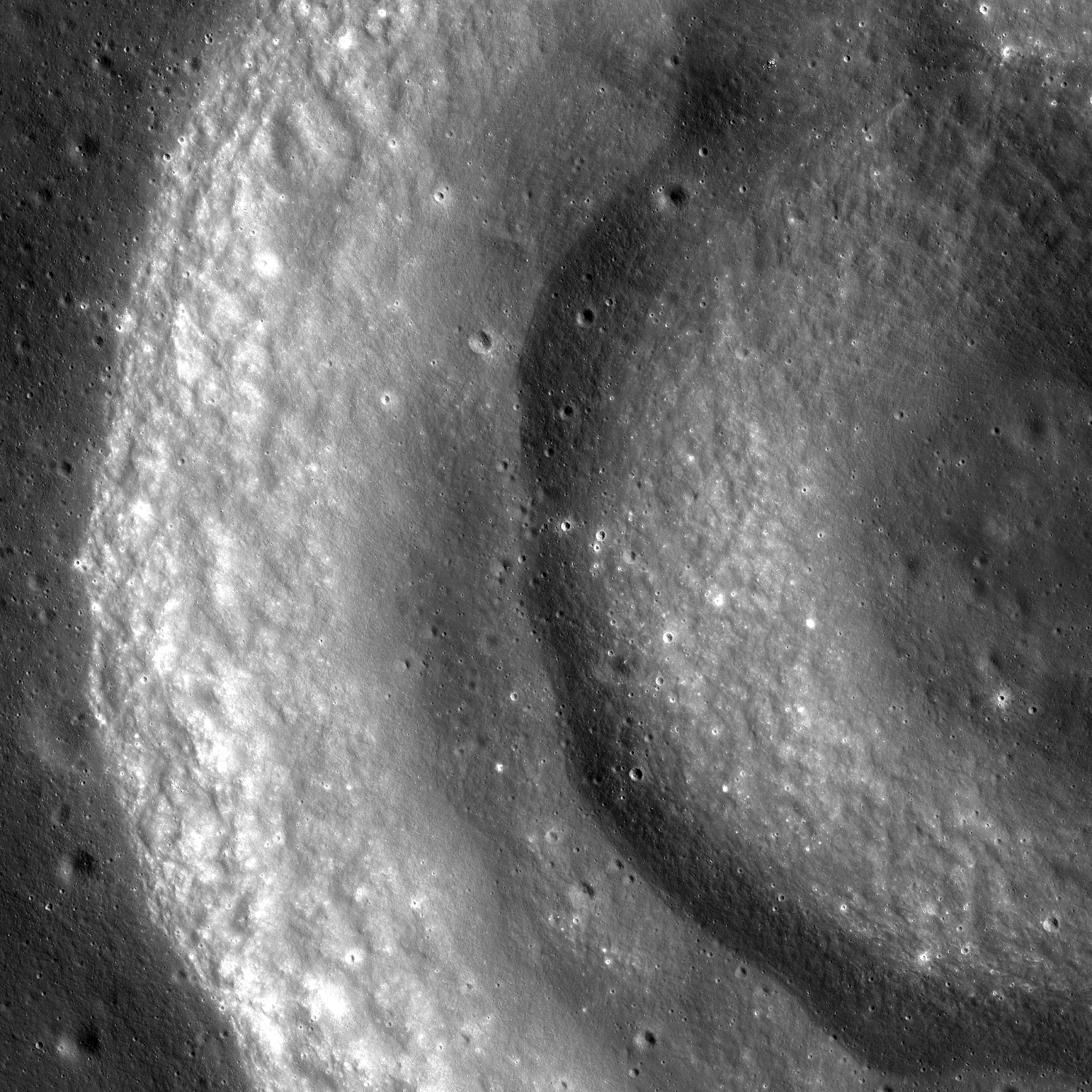
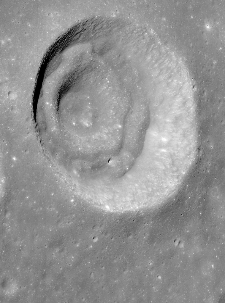
Oblique view of an unnamed but prominent 12 km-wide concentric crater in the Apollo Basin, centered on 30.757°S, 205.931°E. Spacecraft and camera were slewed eastward off nadir 57.74° from 76.2 km over 31°S, 200.62°E, LROC NAC mosaic M1097537923LR, spacecraft orbit 14102, July 21, 2012; resolution roughly 2 km in the original [NASA/GSFC/Arizona State University].
Raquel Nuno
LROC News System

The May 22, 2013 Featured Image showed a portion of an unnamed concentric crater located in the Apollo Basin. Today’s Featured Image is a spectacular oblique (58° from vertical) view of that same crater.

Lunar geologists find craters useful in investigations because they tell so much about the geological history of the Moon. Craters reveal structural properties below their surface and the relative ages of the surfaces where they formed. How can looking at a hole in the ground be so insightful?

Combining imaging with numerical modeling and laboratory experiments, we can test how different structural properties beneath craters affect their shape and size, and even derive information about the direction of the impactor that formed the crater. Crater counting lets us estimate how long a surface has been exposed; more craters indicate an older surface. While insightful, these techniques do not conclusively describe the formation mechanism for all observed crater shapes. That is the case for concentric craters such as the one in today’s post, an unnamed 11.5 km concentric crater located in the Apollo Basin, centered at 30.757°S, 205.923°E. Concentric craters have an inner rim whose formation mechanism is not yet entirely understood, but the concentric mounds may indicate that there is a discontinuity, such as layers with different strengths, in the subsurface excavated by the impact.

LROC WMS (Quick Map) Wide Angle Camera (WAC) mosaic of the 11.5 km concentric crater (center), in context with north and northwestern Apollo basin. [NASA/GSFC/Arizona State University].
Craters are beautiful landscapes depicting the violent impact history of the moon, but are also a reminder of how human ingenuity can unravel the formation mechanisms of geological features on other worlds. As is the case for concentric craters, some of nature’s mysteries require on-site human and robotic investigations to fully understand them.

WAC_CSHADE_O000N2400_064P-2943
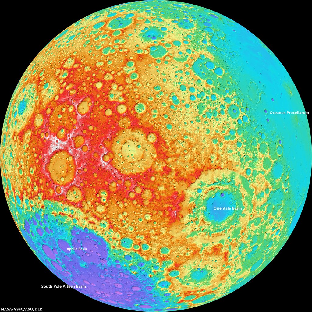
LROC Wide Angle Camera (WAC)-derived global elevation model, hemisphere centered on the equator and 240° east meridian. The Apollo basin, in context inside the rim of 4.26 billion year old South Pole Aitken basin, is at bottom left, site of deep craters - many named in honor of Americans famed for their contributions to lunar exploration - may have excavated samples of the Moon's primeval crust. The Orientale basin, southeast of this view's center, marks the western limb of the Moon's nearside [NASA/GSFC/ASU/DLR],

Investigate and zoom into the full resolution LROC-processed NAC frame, HERE.

Related Posts:
Concentricity in Apollo Basin (May 22, 2013)
Concentric crater (Gruithuisen K - August 4, 2010)
LOLA's Apollo Basin (April 24, 2010)
Apollo Basin: Mare in a Sea of Highlands (March 30, 2010)
"Biggest, deepest crater," an excavation of the hidden, ancient Moon (March 6, 2010)

Wednesday, May 22, 2013

Concentricity in Apollo Basin

Portion of an unnamed concentric crater in Apollo Basin. Sun is incident from the right to the left. LROC Narrow Angle Camera (NAC) mosaic M1122245918LR, orbit 17571, May 3, 2013; image field of view is 6.3 km [NASA/GSFC/Arizona State University].
Sarah Braden
LROC News System

The double-arch shape in the Featured Image is a portion of an unnamed concentric crater located in the northwestern extent of Apollo Basin (basin center at 35.687°S, 208.232°E).

The concentric crater has an inner ring, centered on 30.757°S, 205.931°E, a middle ring, and then the crater rim.

The crater formed within the mare basalt that fills Apollo Basin. The formation mechanism for concentric craters like this one is not entirely clear. One theory is that the target material is made of multiple stratigraphic layers with different strengths. If the difference between the strengths of the layers is great enough, the impact may form concentric rings.

Bench craters also form when target layer strengths are different.

Oblique NAC view of the unusual crater morphology in Apollo basin. LROC NAC mosaic M109753923LR, orbit 14102, July 21, 2012; camera and spacecraft slew off nadir 57.74° resolution roughly 2 meters per pixel from 76.2 km over 31°S, 200.62°E [NASA/GSFC/Arizona State University].
In the late 1960s laboratory experiments replicated the concentric shape of craters using targets with loose, granular material over stronger, more cohesive layers. The laboratory experiments use different materials and are at smaller scales than their lunar counterparts. Still, experiments like these are important for comparing what we see on the lunar surface to basic physical principles. What if an impact occurs in an area with highland material as one layer and then mare basalt as a second layer? What crater shape is produced if you introduce a regolith layer? These are the questions that lunar geologists use to design their experiments.

LROC WMS Wide Angle Camera mosaic of the concentric crater in context with north and northwestern Apollo basin, The crater of interest is 11.5 km across [NASA/GSFC/Arizona State University].
Explore the entire LROC NAC mosaic, HERE

Related Images:
Concentric Crater (Gruithuisen K)
Apollo Basin: Mare in a Sea of Highlands
Small Pond
LOLA's Apollo Basin
Biggest, deepest crater - an excavation of the hidden, ancient Moon

Sunday, September 11, 2011

The thinking behind the GRAIL twins


A useful view of our heterogeneous Moon. A practical illustration of the thinking behind the GRAIL project. From several thousand kilometers above the southern hemisphere and just below the equator of the lunar Farside it’s easier to see our Moon is “lumpy;” perhaps like the asteroids, it's own mass isn't high enough to crush it into a unified solid. From the standpoint of gravity the Moon retains the the memory of the smaller solid and semi-solid bodies from both before and after it's original formation. So nothing stays in close orbit around the Moon for very long without getting a frequent boost, and such boosts need fuel and fuel eventually runs out. This false color map of the lunar surface shows, in low resolution, differences from average elevation, or datum. Mare Orientale is on the right, and just beyond, so a crescent of the Nearside’s is visible. The expanse of the Farside here is defined, by the ancient South Pole Aitken basin, with the Moon's thinnest crusts, below center left, and by the Moon’s highest elevations and thickest crusts in the Farside highlands spread above the SPA rim (yellow box shows field of view in the next illustration [NASA/GSFC/MSFC/LOLA/LMMP/LP].

The Lunar Reconnaissance Orbiter (LRO) has orbited the Moon over 10,000 times since June 2009, mostly in a low and circular polar orbit. It requires a monthly boost to keep its record-breaking mission going. A common demonstration of the Moon's mass concentration (MASCON) problem is a thought experiment. A future astronaut stands on the rim of the Nearside impact basin Mare Imbrium holding a weight suspended a meter below a gloved hand sees that it doesn't hang straight down. Instead it hangs angling slightly toward the center of the basin hundreds of kilometers away. Anything in orbit is alternately tugged or gains slack changing its speed, causing it to eventually crash. This inconvenience, when carefully recorded and studied, is also a good way of mapping the Moon's interior in 3D.

The elevation map above shows how radically different the Moon’s Farside is from the familiar Nearside. In a photographs the extent of the 4 billion year-old SPA basin and the higher ground and its rim don’t stand out nearly as well. The map is plotted from millions of laser points measured from LRO's orbit to and from the lunar surface by the LOLA instrument, shown here using the ILIADS program available from NASA Marshall Space Flight Center. The yellow rectangle shows the field of view shown in an August 2011 release of LOLA science from the Goddard Space Flight Center.


NASA/GSFC, August 15, 2011 - Twenty-five years have passed since seven brave astronauts lost their lives in the Challenger accident. As the Shuttle program comes to an end, we are reminded of those who lost their lives in the pursuit of human exploration. Shortly after the accident, the Challenger astronauts were memorialized by having lunar craters named after them. These seven craters, located on the far side of the Moon in the Apollo Basin, expose deep portions of the lunar crust.

This LOLA image reveals that the depths of McNair and Jarvis craters, in particular, reach nearly 7 km below the lunar datum (the Moon's equivalent of 'sea level'). The depth of McNair and Jarvis is due to their placement within the large Apollo Basin (an existing topographic low) as well as the Apollo Basins location in the even larger South Pole-Aitken Basin. When combined with data from other LRO instruments such as LROC and Diviner, and instruments aboard other spacecraft such as the Moon Mineralogy Mapper (M3) aboard Chandrayaan-1, the complex nature of the Challenger craters is revealed. Data from the M3 instrument reveal that Jarvis crater's composition may represents a deep portion of the lunar crust.

References

Steigerwald, B. (2010) "Biggest, Deepest Crater Exposes Hidden, Ancient Moon," June 2, 2011.
Robinson, M. (2011) "Challenger Astronauts Memorialized on the Moon," January 28, 2011, LROC
Petro, N., et al. (2010) "Lower Crustal Materials Exposed in the Apollo Basin Revealed Using Moon Mineralogy Mapper (M3) Data," 41st Lunar and Planetary Science Conference, #1802, March 2010.

LOLA original map: small | large 


Japan’s lunar orbiter Kaguya (SELENE-1, 2007-2009) vastly added to our knowledge about the “hidden Moon” originally gathered through the Apollo era and afterward, stitched together by 2005. Along with the first HDTV from lunar orbit, Kaguya was a platform for a variety of instruments, including laser altimetry, like LRO. The Kaguya LALT system itself built up an elevation map that is only very recently being surpassed by LOLA during the past two years.

Using their links with Kaguya, with its sub-satellite R-SAT, and in a manner very much like the mission plan for GRAIL-A and B, JAXA investigators delicately measured Doppler shift and subtle light-speed changes between each orbiting spacecraft and with the ground to built-up a detailed map of the Moon’s "gravimetric anomalies."

Together with the unprecedented detail of the Moon’s crustal thicknesses, seen in maps like the one below, Kaguya presented scientists with new and very much more detailed faces of the Moon. Kaguya investigators also helped refine the elusive center of the Moon, from within 20 to 2 kilometers, much more.


The relative thickness of the lunar crust as teased out by Japan's Kaguya orbiter and its sub-satellite R-SAT. The Moon's MASCONS and 'negative gravity anomalies' don't necessarily manifest themselves in surface features, like the one associated with Mare Imbrium.[JAXA].

GRAIL-A and B will join LRO and the recommissioned ARTEMIS twins for a grand total five American unmanned lunar missions, all orbiting the Moon at the same time by the end of the year. The skies above the Moon will become nearly as crowded as those of Mars.

The GRAIL twins will pick up the task of mapping our lumpy Moon’s mass, ARTEMIS the intricacies of the Moon’s plasma wake and its interaction with Solar wind as the Moon orbits through Earth’s magneto-tail with LRO continuing to map the lunar surface from more lasting, slightly higher polar orbit.

All this latter-day renewed interest in the Moon began as preparation for an eventual return, inspired by the loss of Columbia in 2003. That original timeline for renewed, extended human activity on the Moon may seem much further away once again, for the moment, but these unmanned “precursor missions” set into motion through the vagaries of reaction to tragedy or short-term public policy shifts are well along in the pipeline, on time and under budget.


LROC Wide Angle Camera (WAC) monochrome (604nm) mosaic of northeastern Apollo basin, from observations in LRO orbits 2068 and 2069, December 8, 2009; field of view roughly 120 km, resolution 78 meters per pixel, incidence 70° The depth of the interior floor of Jarvis and McNair, the larger and smaller of the two co-joined craters, respectively, and the largest feature seen above, are roughly 7,000 meters below lunar mean elevation. [NASA/GSFC/Arizona State University].

Sunday, June 26, 2011

Das crater


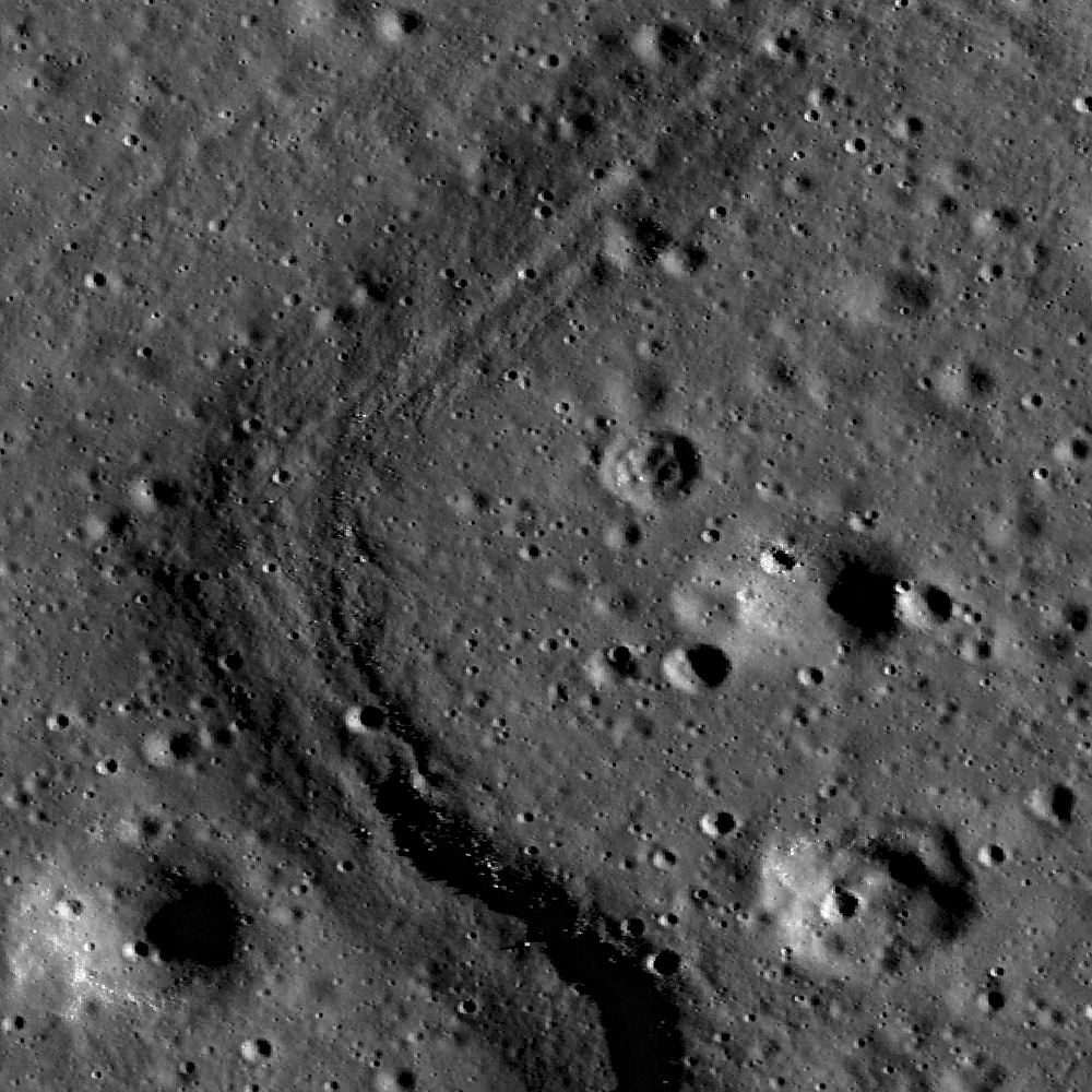
An impact melt pool (lower right) within Das crater. Nearby boulders are the result of fractured impact melt which have migrated downslope and formed talus (upper left). Uphill direction is to the top left. LROC Narrow Angle Camera (NAC) observation M136091866, LRO orbit 5189, August 10, 2010; field of view is 240 meters. See the 600 meter-wide, full resolution LROC Featured Image HERE [NASA/GSFC/Arizona State University].

Drew Enns
LROC News System

Das crater (35 km diameter) is located just northeast of the South Pole-Aitken Basin. The portion of the floor in the opening image is a smooth and flat pool of impact melt. A large amount of energy is created and absorbed by both the bolide and the target during an impact event. The bolide is very nearly vaporized, and a large portion of the target is melted, fractured, and redeposited elsewhere as ejecta. Impact melt, unlike most ejecta, stays primarily within its parent crater, forming intricate patterns as the melt flows downslope and gathers in large pools. Occasionally, impact melt will also spill out of the crater, forming exterior melt deposits.


Context images of Das crater (26.6°S, 223.2°E). On the high northeast rim of 4 billion-year old South Pole Aitken basin, 280 km northeast of some of the deepest excavations within the Apollo impact basin just inside SPA [NASA/GSFC/Arizona State University].


But how do scientists know that this pond within Das crater is in fact impact melt? Solving this puzzle requires the geologic context of this small pond within the crater. As discussed in yesterday's Featured Image, the volume and texture of the pond help piece together the puzzle. Das' crater floor in the context image is not smooth or flat and is made up of several pools of ponded material. This is unlike Jenner's singular flat crater floor. The distribution of these ponded materials gives us our next clue! The ponds are at separate elevations within the crater and flow downslope! This is not what we expect to see in a mare flooded crater when a massive amount of lava is sourced from a low elevation. These observations all point to impact melt as the best explanation for this pooled material.

Look for more impact melt within the full LROC NAC frame!

Related Posts:
King Crater's Unusual Melt Pond
Out of the Shadows Impact Melt Flow at Byrgius A Crater
Forked Impact Melt Flows at Farside Crater

Monday, January 31, 2011

IAU names craters to honor Columbia crew

Columbia crater group, Apollo basin (Chang'e-2)
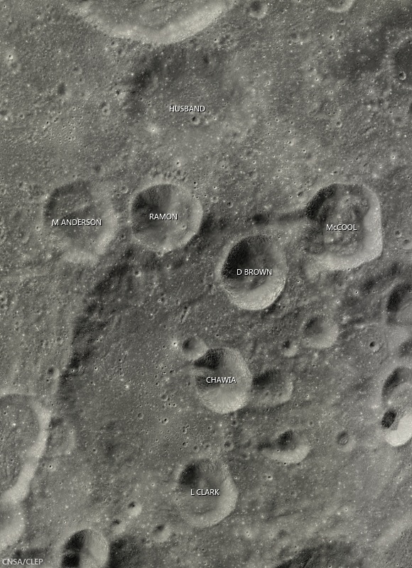
Craters in this grouping on the southeast side of the ancient Apollo basin have been preliminarily named in honor of the crew members of Space Shuttle Columbia, who perished during re-entry February 1, 2003.  Though some in the group seem to be large secondary craters from the same event Husband, formerly Borman L, is older than the others  Field of view from Chang'e-2 global high-Sun mosaic [CAS/CNSA/CLEP].
Keith Cowing, at the Lunar Orbiter Image Recovery Program (LOIRP) website "Moonviews" reports a crater grouping in Apollo basin (35.7°S, 208.0°E) has been provisionally designated by the International Astronomical Union to honor of each of the seven astronauts who died in the catastrophic failure of Space Shuttle Columbia February 1, 2003.

Columbia group, Apollo basin
Columbia crater group, in context with Apollo basin and craters there named after the Space Shuttle Challenger group, among others. The larger crater at center left, named in honor of Apollo 1 crew member Roger Chafee, is roughly 50 km across  [NASA/USGS/ASU].
Columbia crater group, lunar farside (LROC WAC DTM)
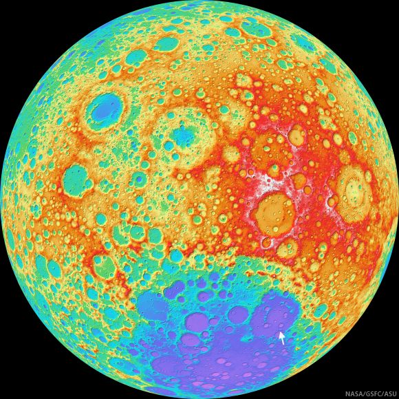
Locating the Columbia crater group (arrow) in Apollo basin, itself nested near the edge of the South Pole-Aitken basin, on an orthographic projection of the lunar farside. False color elevation map from LROC Wide Angle Camera digital terrain model (WAC DTM) [NASA/GSFC/ASU].

Friday, January 28, 2011

The Challenger Crater Group of Apollo Basin


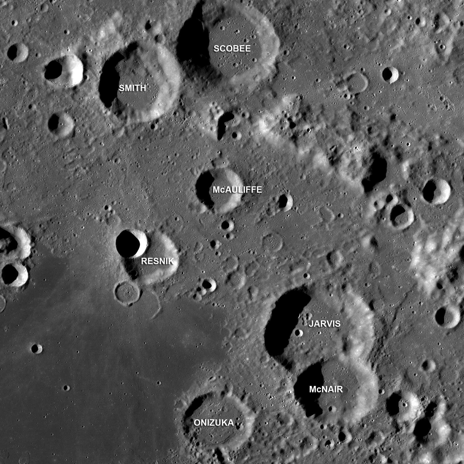
The Challenger Crater Group in Apollo Basin, on the Moon's farside (36°S, 209°E); LROC Wide Angle Camera monochrome (643nm) mosaic from a series of passes stitched around M118491411ME, gathered over the course of three orbits January 18, 2010. The crater group is named for the crew of the Space Shuttle Challenger killed when America's second orbiter was destroyed by an external tank explosion 73 seconds after launch from Kennedy Space Center, January 28, 1986. Craters elsewhere in the basin were also officially designated to memorialize the crew of Apollo 1 and Columbia [NASA/GSFC/Arizona State University].

Mark Robinson
Principal Investigator
Lunar Reconnaissance Orbiter Camera
Arizona State University


Apollo is a 524 km-diameter impact basin located within the center of the the giant South Pole-Aitken basin. Apollo is also a Constellation Project Region of Interest, identified by NASA as a notional area for future human lunar exploration. The Constellation ROI is located in the southwest corner of the mare deposit that fills this basin-within-a-basin.

After the loss of the Space Shuttle Challenger these seven craters on the eastern rim of Apollo were named after Greg Jarvis, Christa McAuliffe, Ron McNair, Ellison Onizuka, Judy Resnik, Dick Scobee and Mike Smith.

View the WAC mosaic of the entire Apollo basin and surroundings.

Visit NASA's Day of Remembrance webpage, HERE.

Saturday, April 24, 2010

LOLA's Apollo Basin

From Lunar Pioneer 3
An unprecedented depth of laser altimetry resolution from data built up into a false color image of 537 km-wide Apollo Basin. The LOLA (Lunar Orbiter Laser Altimeter) is on-board NASA's Lunar Reconnaissance Orbiter (LRO) [NASA/GSFC]

LOLA (GSFC) - Located in the northeast corner of South Pole-Aitken (SPA) Basin, Apollo Basin is a multi-ringed impact remnant approximately 537 km across. Lunar Orbiter Laser Altimeter datasets gathered from the vantage of the Lunar Reconnaissance Orbiter's ~54 kilometer-high nominal-mission, circular polar orbit reveals Apollo's "significantly degraded" outer rim and a partially buried inner rim.


Before LOLA, the most detailed laser altimetry of the Moon's topography was barely a year-old, gathered using the LAT instrument package on Japan's first lunar orbiter SELENE-1 (Kaguya). Apollo Basin is nearly a quarter the width the vast 2100 km (4 billion year-old) South Pole-Aitken Basin, or 'SPA.' A very deep impact within a deep impact, recent analysis of the deepest interiors of Apollo has uncovered remnants of the Moon's original global crust [JAXA/SELENE].

Apollo Basin has been featured in the news recently (See "'Biggest, deepest crater,' an excavation of the hidden, ancient Moon," March 6, 2010), with discoveries of crustal material previously unseen on the lunar surface. When used with datasets from other instruments (such as M3 from Chandrayaan-1) high-resolution topographic data from LOLA can help scientists understand the extent of this previously unseen lunar crustal material.


Interior of Apollo basin - HDTV (2008) Japan's Kaguya lunar orbiter [JAXA/NHK/SELENE].

Wednesday, March 31, 2010

Deep Sea of Highlands


Two views from a high resolution (LROC Narrow Angle Camera) image of the floor of Apollo Basin, the large (see "The Biggest Deepest Crater," March 6) double-ringed impact crater in the southern hemisphere of the Moon's far side. This image shows part of the boundary between two flow units within the volcanic mare deposits on the crater's floor.

The sharp boundary between the topographically higher lavas on the right side of the image and the lower ones on the left reveals layers, suggesting that multiple volcanic events were involved in forming some of the isolated volcanic plateaus seen within the otherwise uniform crater floor lava flows. Both the high and low materials here are heavily covered in impact craters, indicating that these lavas, like much of the Moon's surface, are ancient. Many boulders can also be seen shedding out of the upper layers and eroding down onto the lower deposits. Image is 880 meters wide, and north is up. Part of NAC frame M114953774LE [NASA/GSFC/Arizona State University].

Jim Bell
LROC News System

Unlike features on the nearside, craters and other landforms on the Moon's fars ide were only discovered beginning with the advent of the Space Age. Thus, many features have names that reflect more modern historical figures, places, and themes. One such example is the Apollo impact basin, a 538 km wide double-ringed impact crater in the southern hemisphere of the lunar far side, centered near 36°S, 208°E.

From a LROC Wide-Angle Camera mosaic (really worth a look here) showing most of Apollo Basin's northern, southern, and western inner ring as well as the central floor's dark mare basalt deposits. The white arrow shows the location of the high-resolution NAC image discussed above. The white "X", near the boundary of the smooth, dark floor deposits and the rougher, brighter inner ring highlands materials, is the center of one of the 50 Constellation Program ROI's or "regions of interest." The large (~51 km) crater at upper left is Dryden; the largest (~49 km) crater partially visible just to the left of center at the bottom of the mosaic is Chaffee. North is up, and the width of mosaic is 130 km [NASA/GSFC/Arizona State University].

This large feature was named in honor of the Apollo program (1968-1972), NASA's manned missions that culminated in twelve astronauts landing on the surface of the Moon, conducting scientific experiments and returning more than 380 kilograms of samples to Earth. Many individual craters within the Apollo Basin are named after deceased NASA astronauts and pioneers, including, more recently, craters named after the crews of the Space Shuttles Challenger and Columbia.

Apollo crater is an outstanding example of a concentric, double-ring impact structure, "transitional" in size, between smaller simple bowl-shaped and complex central peak or peak-ring craters and larger impact basins like Mare Orientale.

It is actually superimposed within the enormous, much older South Pole-Aitken (SPA) Basin, an impact structure that is one of the largest in the Solar System dominating the far side southern hemisphere. Apollo was selected as one of 50 sites for LRO to investigate in great detail as examples of the range of scientific questions and engineering challenges to be addressed in future human and robotic exploration of the Moon. The specific study area (centered on the white "X" in the WAC context image above) was chosen because of the presence of relatively rare far side deposits in close association with bright, presumably anorthositic highlands materials of the basin's inner ring of mountains.

Because the crater formed on the rim of the South Pole-Aitken Basin it's possible some of the materials excavated and uplifted by the Apollo Event may have originated at great depths, perhaps even down to the lunar mantle. The site also offers interesting operational challenges for astronauts and robotic missions, offering rare far side opportunities for science and exploration within both highlands and mare terrain.

Explore the Apollo crater Constellation region of interest for yourself, as well as other previously released images showing spectacular views of Orientale Basin and examples of simple bowl-shaped and complex central peak craters.