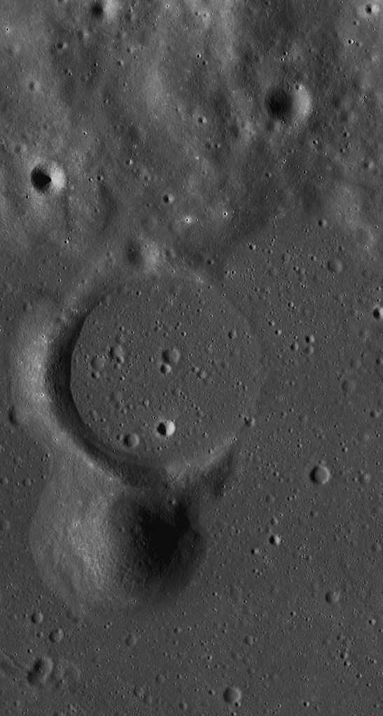
The northern flank of the dome partially covers the southern rim of a partially submerged pre-mare, impact crater (approx. 7 kms in diameter), which appears to have undergone subsidence to the east, where the craters wall is only visible as a feint 'ghost ring.' The height of the western rim is approximately 200 m above the mare surface, giving an indication of the vertical displacement affecting the eastern rim. This subsidence could be the consequence of crustal downwarp, but may also be a result of faulting, with the eastern wall being on the downthrow side of a north-south orientated fault. It is worth noting that a continuation of Rima Yangel to the west would intercept the crater rim at the position of the breach, though if this tectonic feature is related to the breach, it does not extend to the craters western rim.
Evidence for subsidence or faulting is provided by the overall morphology of the dome and the rather 'off-center' appearance of the upper slopes relative to the apron as seen in Fig.1B with the apron to the west of an apparently greater extent than to the east. It is possible that if this apron was previously symmetrical, tilting would have lowered its level in the east with subsequent obscuration during the emplacement of the mare lavas, as is the case with the eastern crater rim.
 |
| Figure 1A and 1B - LROC (Arizona State University) Quickmap and NAC images show the effusive dome on the north edge of Mare Vaporum (A) and detail (B) showing possible vent complex (circled:B) and dark mantling (DM) on the ghost crater's southern wall. B: LROC NAC M181144987LR, LRO orbit 11810, January 14, 2012, scaled down from 1.3 meters per pixel resolution, from 128 km [NASA/GSFC/Arizona State University]. |
The dome itself appears to be divided into two distinct zones in elevation, the lower slopes comprising a relatively smooth textured debris apron of even albedo, and more rugged the upper slopes which appear to have a lower albedo surface layer overlying a subsurface of a higher albedo.
This may reflect mass wastage of the darker surface layers on steeper slopes to reveal either a fresh, low maturity soil beneath or soils of differing composition. The surface albedo of the northern flank appears lower than elsewhere on the dome, which may indicate the presence dark pyroclastic mantling deposit.
The summit of the dome is occupied by a number of rimless depressions, with the most conspicuous being roughly square in outline (approx. 400 m across) within which is a large smooth rimmed crater (approx. 150m diam). This square feature (Fig.2A) appears to be displaced slightly to the east of the dome summit, possibly as a result of subsidence which is discussed above. The square depression appears to be bounded by a fault scarp, whilst the smooth rimmed central crater within lacks a sharp rim, and may be of volcanic rather than an impact origin. This square depression and central crater may represent some form of vent complex.
The eastern side of the dome shows evidence of slope failure, with an arcuate scar cutting the upper eastern flank, beneath which the slope is modified by radial and sub radial grooves, possibly representing erosion gullies. This asymmetric slope failure affecting the eastern flanks may be related to the subsidence postulated above. This presumes that the dome was emplaced prior to any episodes of subsidence and therefore prone to de-stabilising slope modification occurring as a result.
To the north of the dome and lying on the inner slope of the ruined crater wall is an area covered by a low albedo mantle. These low albedo deposits are patchy, with a darker surface layer overlying a lighter subsurface, again possibly as a result of exposure of fresh, immature material or material of a differing composition.
 |
| Figure 2A - Full resolution (40 cm) resolution detail of depression and crater within - LROC NAC M168183822LR [NASA/GSFC/Arizona State University]. |
 |
| Figure 2B - Under high Sun, dark mantle deposits on ruined ghost crater rim and wall with adjacent lighter boulder field. LROC NAC observation M1103545264LR, spacecraft orbit 14944, September 29, 2012, angle of incidence 20.62° at 1.02 meters resolution from 126.06 km [NASA/GSFC/Arizona State University]. |
This low albedo area is flanked to the west by a zone where the albedo of the inner crater wall is considerably higher. A detailed view reveals that it is composed of multiple, often superimposed boulder trails that appear to have originated from exposures along the upper margins of the inner crater wall (Fig. 2B). These trails form a boulder trail field with the boulders responsible visible in considerable numbers lying on the crater floor. It is possible that the low albedo dark mantled area was previously more extensive, but that a large area of it was disrupted during the formation of the boulder trail field. Evidence for this can be seen in the form of isolated patches of darker materiel within the boulder trail field, which may represent surviving remnants of the original mantling. The upper slopes of the dark mantled areas are largely clear of trails but isolated boulders are visible. In contrast the lower slopes do contain both trails and boulders. This may indicate that the lack of trails on the upper slopes reflect a later phase of localised dark mantling that obscured any trails that were present, but left the boulders responsible still visible. The existence of these multiple boulder tracks indicate a significant ground disturbance that dislodged large numbers of boulders from the crater wall. This may be related to the subsidence or down-faulting discussed above, or to volcanically induced seismic disturbance during the active phase of the domes growth.
The Clementine UVVIS ratio enhances color differences related to soil mineralogy and maturity. The color ratio image is obtained assigning the R750/R415, R750/R950 and R415/R750 into the red, green, and blue channels of a color image, respectively.
 |
| Figure 3 - Inset: Clementine 750nm imagery with pyroclastic deposit. Surrounding context: Clementine false color of the region obtained assigning the R750/R415, R750/R950 and R415/R750 into the red, green and blue channels, respectively. The volcanic construct with pyroclastic deposits is marked with an arrow and renders as blue [NASA/USGS/DOD]. |
The lunar highlands are depicted in red (old) and blue (younger) and the maria are depicted in yellow/orange (iron-rich, lower titanium) or blue (iron-rich, higher titanium). The pyroclastic deposit is characterized by a different color respect to the nearby soil and appears blue indicating an increased TiO2 content (Fig. 3). The LPD has a lower 750 nm albedo of about 0. 092, while the examined mare unit is similar to that of the undisturbed crater unit with a 750 nm albedo of about 0. 011, but the LPD has a higher R415/R750 ratio, and is spectrally bluer than the other examined units with lower R415/R750 ratios of ~0.60.
For the spectral study the Multiband Imager (MI) on the Selenological and Engineering Explorer (Selene) with both visible and near infrared coverage in the spectral bands at 415, 750, 900, 950, 1000, 1050, 1250, and 1550 nm have been used. The spectral data were normalized using the region of Sinus Aestuum 2 site and calibrated using bidirectional reflectance corrected Keck 120 color spectral data for Sinus Aestuum 2. The color ratio image obtained with Selene-1 MI and assigning the R750/R415, R750/R950 and R415/R750 into the red, green, and blue channels of a color image, confirms the results found with the Clementine imagery but with higher spatial resolution. According to preceding findings the dark material extends beyond the dome itself into the flooded crater to the north, suggesting an ash type deposit and displays a blue color with a compositional contrast between the whole dome and the mare based on the UVVIS ratios imagery (Fig. 4).
 |
| Figure 4 - Ratio color image from SELENE-1 (Kaguya) dataset in which the R750/R415, R750/R950 and R415/R750 are assigned to red, green and blue channels, respectively. A slight contrast enhancement was applied to the RGB image [JAXA/SELENE]. |
We have applied the TiO2 and FeO estimation equations by Lucey et al. (2000)*. The derived values for FeO and TiO2 are then converted to Fe and Ti elemental abundance by multiplication for the factor (56/72) and (48/80) respectively, according to the atomic weights of the constituent elements. According to the Clementine and Selene-1 color ratio images, the Ti map indicates that the pyroclastic deposit has a Ti contents between 5.0 and 6.2 wt% corresponding to a high TiO2 content of 8.4-10.2 wt%. The elemental abundances of the mare units correspond to a lower Titanium content of 2.7-2.9 wt% (4.5 - 4.8 wt % as TiO2). The Fe map, obtained with the method described by Lucey et al. (2000), shows that the LPD has a Fe contents between 13.4 wt% and 14.0 wt% (17.7 wt% - 18.0 wt% as FeO), with a slightly lower Fe content in the nearby mare soil.
We also used the Chandrayaan-1’s Moon Mineralogy Mapper (M3) data between 460 to 3000 nm. For this work M3 data at a resolution of 140 mpp were calibrated and photometrically corrected and converted to apparent reflectance. These spectra are not thermally corrected, so they are not analyzed for wavelengths longer than 2300 nm as these have a significant thermal emission component. In order to characterize the 1000 nm band a continuum removal method that enhances the characteristic of the 1000 nm absorption band was used. We fit a straight line between 750 and 1500 nm to remove the continuum.
 |
| Figure 5 - Image of study area from M3 (Chandrayaan-1) dataset (Left). The LPD, the northern crater and mare unit east of the crater are marked. At right, M3 spectra of the examined units [NASA/ISRO]. |
 |
| Figure 6 - M3 spectra of the pyroclastic deposit located on the surface of the volcanic dome, previous described by the authors, HERE. |
In the mare unit and in the pyroclastic deposit spectra weak inflections over 1000 nm are detectable, but we wouldn't regard this as an unambiguous identification of olivine, because M3 spectra of high-olivine soils show a much broader absorption.
The spectral signature of olivine has a wide band centered beyond 1000 nm, while the pyroxenes displays a narrow trough around 1000 nm, with a minimum wavelength below 1000 nm, and a wide absorption band around 2000 nm. Interestingly, the dark pyroclastic deposit has a narrower absorption (centered at 970 nm) than the mare unit, such that it cannot be enriched in olivine when compared to the mare. Probably the previously detected Clementine-specific olivine signatures are only partially due to olivine but also due to mis
-calibration. Although the continuum-removed M3 spectrum of the crater seems to be noisy, it displays three absorption bands centered at 920, 970 and 1029 nm, likely due to admixed quantity of pyroxenes and olivine.
 |
| The effusive dome (center) lords over the northern extremes of Mare Vaporum in this view of the north central nearside captured on Earth (stacked CCD image) and processed by Astronominsk, May 31, 2009. Twenty-one kilometer wide Conon crater adds some scale to the area, scoured out by the Imbrium basin-forming-impact 3.8 billion years ago. Under sunrise illumination, the dome's true height can be seen clearly [Astronominsk]. |
The Christiansen Feature (CF) from Gridded data record (GDR) level 3 data product of Diviner Lunar Radiometer Experiment/Lunar Reconnaissance Orbiter (Diviner) data were used for further analysis. The Lunar Reconnaissance Orbiter’s (LRO) Diviner Lunar Radiometer Experiment has a spatial resolution of 950 m per pixel. Diviner produces thermal emissivity data, and can provide compositional information from three wavelengths centered around 8 µm that are used to characterize the Christiansen Feature (CF), which is directly sensitive to silicate mineralogy and the bulk SiO2 content. Silicic minerals and lithologies exhibit shorter wavelength positions at 8 µm channel. For the study area, CF values of 8 µm are towards longer wavelength (CF ~ 8.3 µm) indicating less silicic composition.
Email: Raffaello Lena <
gibbidomine@libero.it> Barry Fitz-Gerald <
barryfitz_gerald@hotmail.com>
REFERENCE: Lucey, P. G., Blewett, D. T., Jolliff, B.L.
Lunar iron and titanium abundance algorithms based on final processing of Clementine ultraviolet-visible images,
J. Geophys. Res., 105(E8), 20,297–20,305 (2000)
(*) Mapping FeO and TiO2 content
Classic approaches to the estimation of FeO and TiO2 are based on the evaluation of Clementine UVVIS reflectance. Lucey et al (2000) derive the equation:
Wt % FeO = 17.427θFe – 7.565
where θFe is calculated according to: θFe = - arctan [(R950 / R750) – yFe / R750 – xFe] as the polar angle in the R950 /R750 vs. R750 diagram with respect to the reference point (xFe, yFe ) = (0.08, 1.19).
Similarly for the abundance of TiO2 Lucey et al. (2000) obtain the relation:
Wt % TiO2 = 3.708 (θTi )5.979 with θTi = arctan [(R415 / R750) – yTi / R750 – xTi] as the polar angle in the R415 /R750 vs. R750 diagram with respect to the reference point (xTi, yTi ) = (0.0, 0.42)