
 |
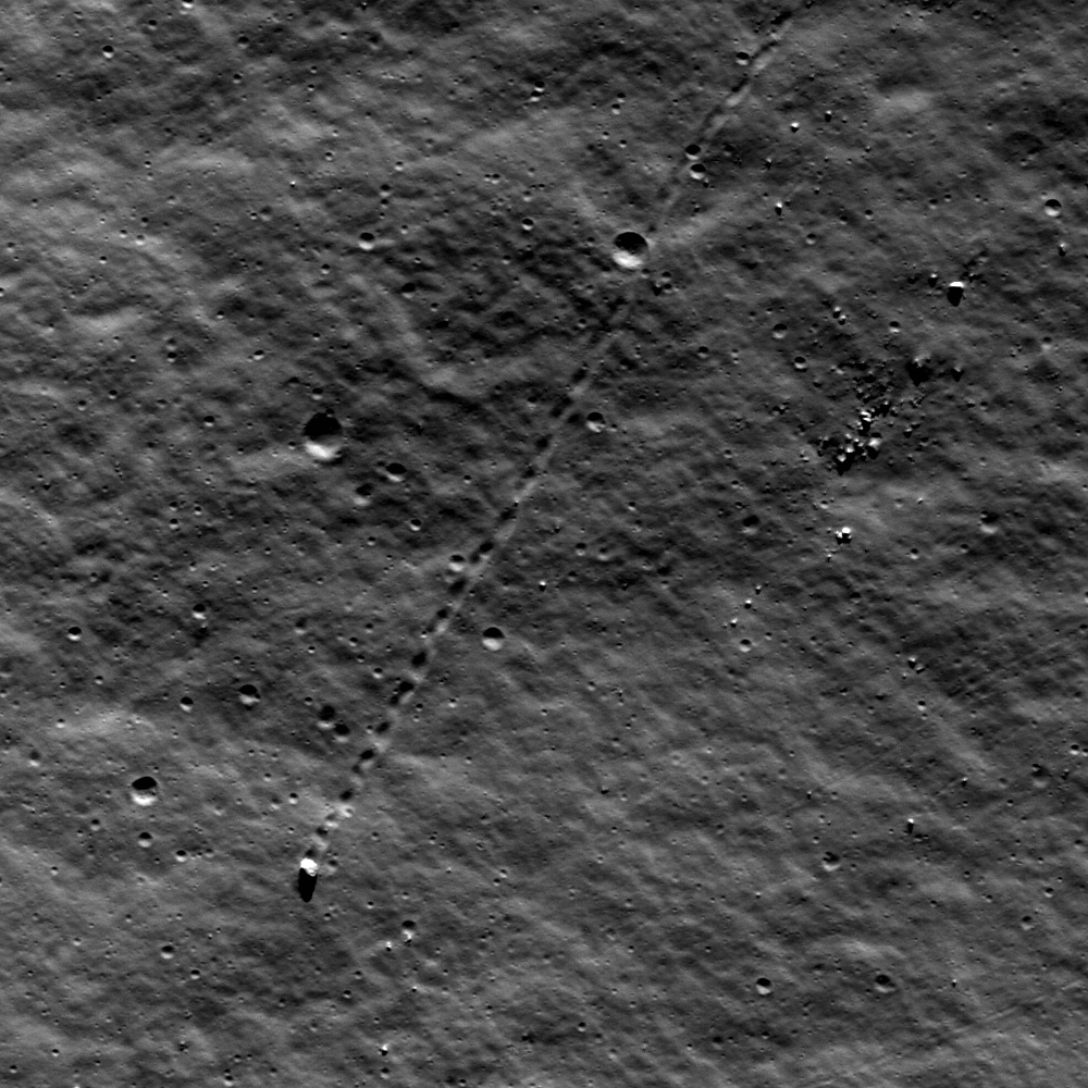
| A large boulder stopped on its way down a sloping wall in the central peak complex of Schiller crater (51.8°S, 320.0°E). Illumination from the north, image is ~500 m across, LROC Narrow Angle Camera (NAC) observation M109502471L LRO orbit 1271, October 6, 2009. See the more detailed full size LROC Featured Image HERE [NASA/GSFC/Arizona State University]. |

LROC News System
The lonely journey of this large boulder is apparent from its track in a sloping regolith surface. A casual glance might suggest that it happened last week, or even that its rolling might resume at any moment. However, closer inspection will detect a few craters that clearly superpose and therefore post-date the track, showing that this 9-meter diameter boulder stopped rolling some time ago. Impacts are used in this way to provide a relative sense for the timing of events on planetary surfaces across the solar system. The procedure assumes a steady flux of impacting bodies in each size range, with smaller impacts being much more frequent than large impacts.
Though long ago to humans, however, this boulder's journey was made in geologically recent times. Studies suggest that regolith development from micrometeorite impacts will erase tracks like these over time intervals of tens of millions of years. If rate estimates are accurate, this boulder track might not be older than 50-100 million years. Eventually its track will be erased completely. What might have caused the rock to roll so recently? Perhaps this boulder was sent on its way by ground-shaking caused by the violence of a nearby impact. Perhaps a direct hit by a small meteoroid did the job.
 |
| Wide Angle Camera (WAC) mosaic image covering a portion of Schiller crater, north is up, image is ~80 km across [NASA/GSFC/Arizona State University]. |
 |
| The LROC WAC Global 100 meter mosaic draped over the laser altimetry (LOLA) digital elevation model as seen from an imaginary point 65 kilometers over the elongated crater's southeast. ILIADS application from NASA Lunar Mapping and Modeling Project (LMMP). South-southeast of center darker surface indicates the location of a localized pyroclastic volcanic dome, with a very low profile. The unusual Schiller crater formation may indicate the formation's progenitor was a highly oblique impact, perhaps along the northern inner rim of an older, much larger impact basin further southwest. Schiller is roughly 108 km wide and 184 km long [NASA/GSFC/Arizona State University]. |
The WAC-derived GLD100 Digital Elevation Model (DEM) of the area, shown in the inset below, offers a sense for topographic relief unavailable in the WAC mosaic alone. We can see that the location of today's Featured Image is in a zone of relatively gradual slope, just beyond the steeper slopes of the Schiller central peak complex. Thus, it is unlikely that our boulder will continue rolling anytime soon. It's arrived in an area with too gentle a slope.

Look for other boulder tracks in the full NAC image.
Additional examples of boulder behavior can be seen in A Gathering in Lacus Mortis, Sampling Schrödinger, and Frozen in Time.
No comments:
Post a Comment