Showing posts with label lava tubes. Show all posts

Friday, November 11, 2011

New view of the Sinas pit crater

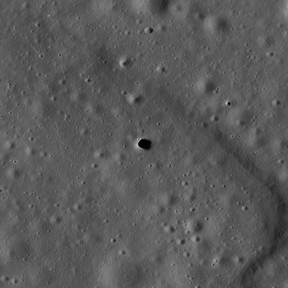
Latest publicly available close-up of the Tranquillitatis pit crater (8.337°N, 33.219°E), LROC Narrow Angle Camera (NAC) observation M155016845R, LRO orbit 7979, March 17, 2011; whose interior is finally seen under a high Sun (incidence angle 10.58°) at a resolution of 47.4 centimeters per pixel from 39.67 kilometers. LROC QuickMap link [NASA/GSFC/Arizona State University].
Joel Raupe
Lunar Pioneer

Since its arrival in lunar orbit in June 2009 every three months LRO investigators have made available data collected by their respective instrument teams during the 90-day period between six and three months prior.

On September 15, for example, the LROC team, led by Dr. Mark Robinson at Arizona State University (and by far the most consciencious of these admittedly very busy science teams), released to the PDS (Planetary Data System) photography collected by their Wide and Narrow Angle cameras (WAC and NAC) between mid-March through  the middle of June 2011. The LROC team has also continued to make improvements to their already impressive set of web-based tools, created for sorting through these vast stores of data, most recently marked improvements to the ACT-REACT QuickMap interface.

So, every ninety days "lunatic" investigators, even rogue investigators like ourselves, everywhere on Earth jump on these data and begin scrambling through an ever-growing list of favorite targets, anxious for any new views or improved resolutions, even a different degree of illumination. Though it's rare when a new high resolution NAC view of a previously imaged location on our list becomes available it's difficult to complain when remembering more than a third of the Moon's surface has now been mapped at a half-meter per pixel resolution or better, or that the entire Moon has, by now, been photographed at 50 to 60 meters resolution several times over, at a respectable variety of illuminations.

After September 15, the date that a seventh batch of LROC observations were released, nearly two months passed before we finally reached the Moon's now-famous "skylights" on our list, in particular the now-famous pit craters at Marius Hills, Mare Ingenii and Mare Tranquillitatis.

No new LROC NAC views appears to have yet been processed of the "Haruyama pit," in the upper stretches of the Sinuous Rille A in the Marius Hills (14.094°N, 303.224°E). A low angle, very detailed image of the huge pit in the Mare Ingenii basin (35.95°S, 166.06°E), captured in 2010, will be hard to improve upon, though perhaps a view revealing more of that formation's boulder-strewn floor under a high sun would help expand our understanding of its extent.

And we've still not had the time to look for any better views of the natural bridge north of King crater, nor what appear to be small pits on the floor of Messier A.  There does not seem to be anything new to add to the little we know about the other, much smaller and far less dramatic "pit" north of the skylight pictured above (and below).

The LROC Science Operations Center at Arizona State University has taken advantage of at least five separate opportunities to capture the Tranquillitatis pit crater, surrounded by the Sinas crater group . All five close-ups are reproduced here in an animated gif, including one "double exposure," positioning the second observation with the third to obtain a better look at the interior before a fifth observation swept up on St. Patrick's Day. A fourth oblique view offered a breathtaking view of subsurface layers, and thus the long and apparently very eventful early history of Mare Tranquillitatis [NASA/GSFC/Arizona State University].
The Sinas group pit crater captures our imaginations perhaps primarily because, like all great discoveries, it raises so many more questions than it answers. These initial historic surveys will be among those things 100 years from now LRO investigators will be credited for as paying the treasure and devotion paid to the entire LRO mission all by themselves.

Sunday, May 15, 2011

Discontiguous Rilles


Northwest end of a disconnected depression, possibly a collapsed or buried segment of Rima Marius (14.53°N, 311.43°E), northwest of Marius C and not far east from a similar phenomena investigated by India's Chandrayaan 1 orbiter west of the Marius Hills. LROC Narrow Angle Camera observation M135507533R, LRO orbit 5103, August 3, 2010; solar illumination incidence 58°, field of view 550 meters. View the full-size LROC Featured Image HERE [NASA/GSFC/Arizona State University].

Hiroyuki Sato
LROC News System

Sinuous rilles (like Hadley Rille, near the Apollo 15 landing site) are narrow, long depressions that meander across the lunar surface like a terrestrial river. Lunar geologists think that sinuous rilles formed either as erupting lavas carved their way through the surface, or by roof-collapse of lava tubes. A portion of the rille (named Rima Marius) in today's Featured Image is discontinuous, with a partially-closed depression that possibly marks the source region for this rille. Perhaps the "blockage" in the channel is a intact lava tube roof.

While there are no signs of any natural bridge structures or other openings in this region, it is possible that a small section of the lava tube might have simply had its entrance and exit blocked by collapse debris.


Jim Irwin captured this spectacular view of Hadley Rille during the second EVA of Apollo 15 in 1971. See the high-resolution image HERE [NASA/ASJ].


Full-width view of the LROC NAC strip shows the discontinuity in some context [NASA/GSFC/Arizona State University].


LROC Wide Angle Camera (WAC) 100 meter / pixel monochrome mosaic view of Rima Marius, with the discontinuity near its terminus, northwest of Marius C [NASA/GSFC/Arizona State University].

Sinuous rilles like Rima Marius are high priority targets for future human lunar exploration in part because they expose deeply buried mare units, meaning that human exploration of locations like Rima Marius will provide important new scientific insights into the duration and evolution of lunar volcanism.

Explore the entire NAC frame!

Related images:
Sinuous Chain of Depressions
Rilles as far as the eye can see in Prinz!
Rimae Posidonius
Rimae Prinz Region - Constellation ROI
Marius Hills Pit - Lava Tube Skylight?


A 3.5 kilometer discontiguous rille west of the Marius Hills that may have had origins in common with the sinuous rille system the winds through those hill's largest mounds, now thought to be one volcano. This image was composed from data collected by the Terrain Mapping Camera on-board India's Chandrayaan-1 [ISRO].

Friday, February 18, 2011

LROC: Sinuous Chain of Depressions


A single depression from a larger sinuous chain of pits located at 34.6°N, 316.5°E, from LROC Narrow Angle Camera (NAC) frame M102443238R. This chain may host uncollapsed lava tubes between the depressions suitable for human habitation. Field of view 1.5 km, solar incidence from the west at 78° Full-sized Featured Image HERE [NASA/GSFC/Arizona State University].

Sarah Braden
LROC News System

This unnamed sinuous chain of pits was suggested to be a collapsed lava tube (see Wilhelms' Geologic History of the Moon). New high resolution NAC images (e.g. M102443238R) provide a new look at the area. This particular feature transitions from a discontinuous sinuous rille into an equally discontinuous wrinkle ridge.


Future Spaceport? Near 35.34°N, 317.57°E, the "Rimae Gruithuisen" chain-rille complex might conceal overlapping 'sublunarian' lava channels, in a part of Oceanus Procellarum replete with the iron and titanium oxide proxies that might mark some of the Moon's deepest reserves of Helium-3, among other promising resources. One day, perhaps a city may spread along the 50 km length of the Gruithuisen chain rille, its residents at least as sheltered from solar storms and cosmic rays as anyone living at sea level on Earth. LROC NAC M102443238L&R, field of view ~5.8 km [NASA/GSFC/Arizona State University].

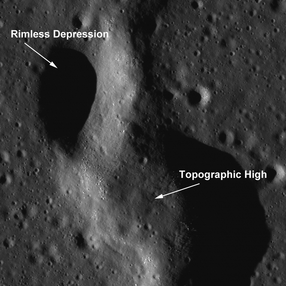
Some scientists have suggested that wrinkle ridge faults interact with lava tubes, with the wrinkle ridge exploiting a zone of mechanical weakness (the lava tube) in the preexisting basalt deposit. In this NAC image, the topographic depressions are non-circular, with collapse rims. Many of the pits have boulders on the interior walls. If these depressions were created by impacts, each pit would have a raised rim and an ejecta blanket.


Pulling back from the Featured Image above for context, a roughly 5.8 km by 10 km segment lifted from the heart of a mosaic of both the left and right frames of NAC observation M102443238L & R, swept up early in the Commission Phase of the LROC mission (from an altitude of 155.57 km, LRO orbit 272, July 17, 2009 [NASA/GSFC/Arizona State University]. Full resolution desktop wallpaper.

Lava tube caves could be used during future human exploration for long-term habitation. Scientists first suggested drained lunar lava tubes as possible human habitats in 1962, and since then the possible lava tube caves have remained at the forefront of both geological debate and the future of a sustained human presence on the Moon. The lunar caves would be an ideal location for a lunar base because they a) require little construction and enable a habitat to be placed inside with a minimal amount of building, b) provide a natural environmental control (insulation and temperature stability), and c) provide protection from natural hazards (i.e., cosmic rays, meteorites, micrometeorite impacts, impact crater ejecta). On Earth, our atmosphere protects us from cancer-causing radiation, but the Moon has no atmosphere and therefore astronauts must find an alternate means of shelter, especially during times of high radiation, like solar flares and coronal mass ejections.


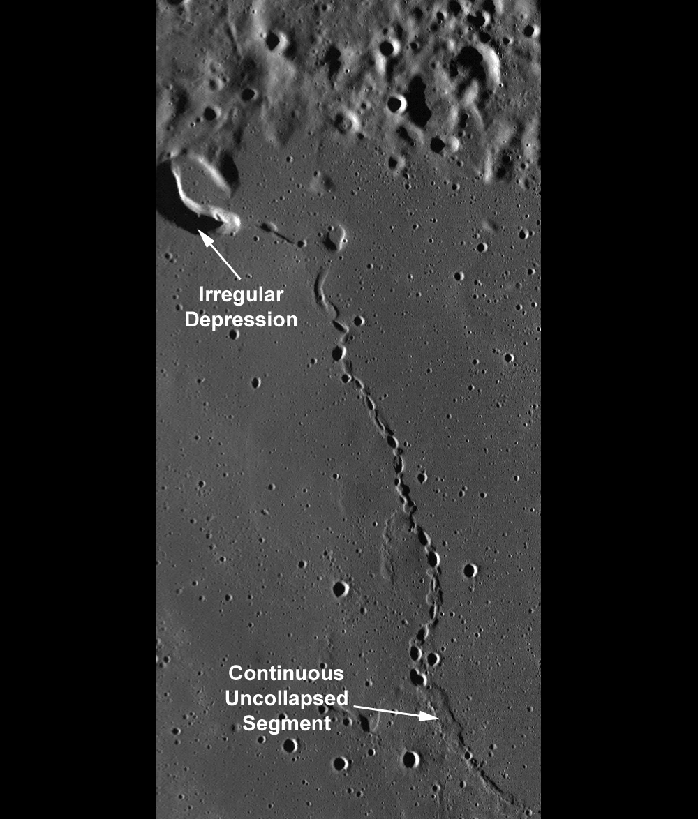
This section of LROC Wide Angle Camera (WAC) monochrome (689nm) mosaic (M117773324-M117780116ME, LRO orbit 2490-2491, January 10, 2010) shows the area where the feature transitions from a chain of collapse pits to a continuous uncollapsed segment. The large, bow-shaped depression at the northwest terminus of the chain may be a possible source region for the flow of lava across this region. The chain is ~50 km long (M117773324ME res. 58.9 m/pixel) View the Full-Sized Featured Image HERE [NASA/GSFC/Arizona State University].

Geologists suspect that lunar lava tubes form similarly to terrestrial lava tubes. However, lunar lava tubes are likely much larger, due to the lower gravity and the lack of an atmosphere. Studies of lava tubes on Earth show that most are hollow. If lunar lava tubes form in a similar way, then they too are most likely hollow. A lava tube may form when an active basaltic lava flow develops a continuous crust. For instance, an open lava channel may form a crust of hardened rock that extends from the sides and, over time, meets in the middle, forming a roof. Even if a lava tube develops a roof, it still has lava running through it. There is a possibility that the cooling lava would solidify inside the tube and block it. However, on Earth most lava tubes do not "plug up." As the rate of lava flowing from the source diminishes over time, the level of liquid in the tube drops, leaving an empty space between the top of the flow and the roof of the tube.

Browse the thrilling full-resolution NAC.

Related Featured Images:
Natural Bridge on the Moon
Concentric Gruithuisen K
Depths of Mare Ingenii
Marius Hills Pit Lava Tube Skylight?


The featured chain rille imaged by the Terrain Camera aboard Japan's SELENE-1 ("Kaguya") in 2008, draped in its context within the Gruithuisen region of the lunar digital elevation model available to users of the Google Earth application [>v.5]. The rille is located in Oceanus Procellarum west of its contact with Mare Imbrium. Sinus Iridum is beyond the horizon at upper right and just below, the point marks the site of the Gruithuisen dome Region of Interest. The concentric crater, above center, is Gruithuisen K [JAXA/SELENE/NASA/GSFC/USGS/Google].

Thursday, July 15, 2010

How common are mare pit craters?


One of three large pit craters so far found on the Moon -- do these pits provide access to open lava tubes? From LROC NAC M106662246R, LRO orbit 861, Sept. 4, 2009; Alt. 133.78 km, resolution = 1.35, phase angle = 29.34° [NASA/GSFC/Arizona State University].

Mark Robinson
Principal Investigator
Lunar Reconnaissance Orbiter Camera (LROC)


The Kaguya team discovered three mare pit craters, all about 100 meters in diameter. Since the Kaguya Terrain Camera had a pixel scale of about 10 meters they could not definitively identify pit craters much smaller than 100 meters. This raises a key question - are there smaller pit craters to be found? The answer is most likely yes.

The LROC team is searching images that are already on the ground and is targeting areas around pits for more coverage. To date, we have about ten candidate pits awaiting confirmation.


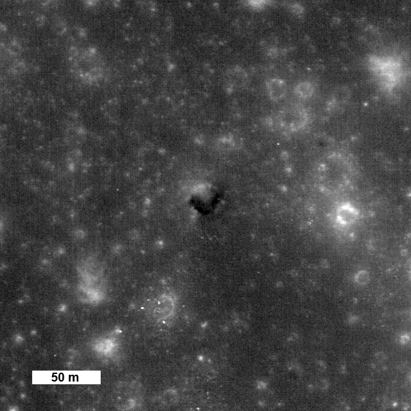
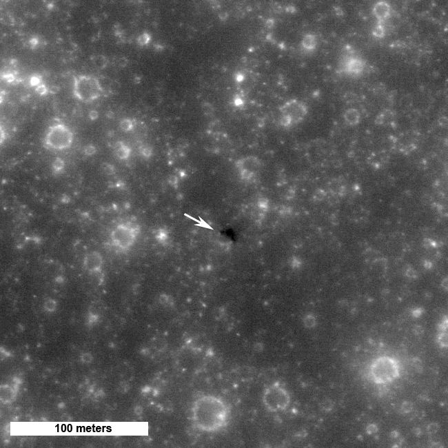
Possible small (25 meter diameter) pit crater in Mare Tranquillitatis observed under high Sun (3° incidence angle). This feature is about 200 km NW of the large pit shown in the opening image. From LROC NAC M124382509L [NASA/GSFC/Arizona State University].

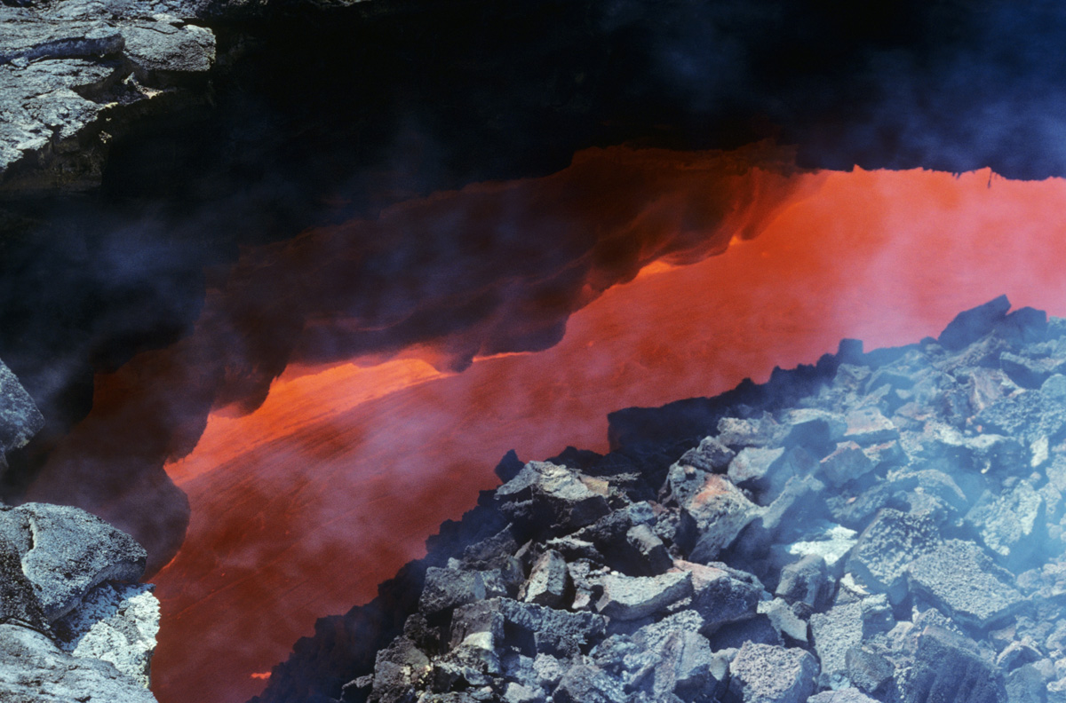
How and when did pit craters form? On the Earth volcanic pit craters are formed as the roof of a lava tube collapses, often while magma is still flowing underground. The resulting opening is often termed a skylight. Can we determine if the lunar pits formed during or after the mare lavas flowed? Perhaps the best place to start looking for evidence is on the pit crater floor. If the crater formed long after eruptions had ceased and the subsurface lava tubes were cold, you might find a chaotic pile of rubble on the floor. If the pit collapsed into an active lava tube you might find the smooth, frozen surface of the last lava to flow through the tube.


View down a skylight revealing magma racing through a lava tube in Hawaii. When lava stops flowing in tubes it cools and forms a smooth surface [photo by Mark Robinson].

The floor of the larger pit does look smooth, but the image of the smaller pit does not have high enough resolution to give a clear picture of the interior. One might infer that the larger pit was formed as an underlying tube was active, though at this stage such a conclusion would amount to healthy speculation. The LROC team is planning to acquire stereo images of the large pits and smaller ones that are now being discovered. The detailed topographic data will allow scientists to confirm the origin of these fascinating pits. Additionally, the LROC team will acquire images at a slant attempting to look for overhangs that might indicate the lava tubes are still open and accessible. Keep checking in as this exciting story unfolds.


Another possible pit crater in Mare Tranquillitatis. LROC NAC observation M109100697RE; LRO orbit 1212, October 2, 1009, Alt. 49.11 km, phase angle 2.54° [NASA/GSFC/Arizona State University].

Examine previous images of lunar pits at Marius Hills and Mare Ingenii.

Explore on your own.


Low-resolution context for two of the three Lunar Reconnaissance Orbiter (Narrow Angle) Camera observations of verified and unverified mare crater pits within Mare Tranquillitatis. (One of the three highlighted by Dr. Robinson up above is not yet released to the Planetary Data System.) Format note: A near perfect "National Geographic-like" font stylizes the upper loop in the '8' of Ranger 8, and it has unfortunately made it appear Ranger 6 impacted the Moon at two widely different locations. Ranger 6 impacted the Moon at or near the northern designation February 2, 1964, though it's television camera had already failed after inadvertently switching on during a booster separation. Ranger 8 was successful, however, in returning televised images of the lunar surface up until the moment of its intentional impact, February 20, 1965; not far from the eventual landing sites of Surveyor 5 and Apollo 11 [Clementine 750nm- NASA/DOD/USGS].

Tuesday, July 13, 2010

NASA@Science: "Down the lunar rabbit-hole"

The 'skylight' in the middle of Mare Ingenii, on the Moon's Far Side, show a tantalizing view of house-sized boulders on part of it's barely illuminated floor in this LRO Narrow Angle Camera (NAC) observation, LROC News System Featured Image released June 16, 2010. Two kilometers wide, the Ingenni pit is twice the size of the skylight previously unveiled by JAXA SELENE-1 (Kaguya) investigators in 2009 - [M128020284LE, LRO orbit 4026, May 11, 2010 - NASA/GSFC/Arizona State University].

Dauna Coulter
Science@NASA

A whole new world came to life for Alice when she followed the White Rabbit down the hole. There was a grinning cat, a Hookah-smoking caterpillar, a Mad Hatter, and much more. It makes you wonder... what's waiting down the rabbit-hole on the Moon?

NASA's Lunar Reconnaissance Orbiter (LRO) is beaming back images of caverns hundreds of feet deep -- beckoning scientists to follow.

"They could be entrances to a geologic wonderland," says Mark Robinson of Arizona State University, principal investigator for the LRO camera. "We believe the giant holes are skylights that formed when the ceilings of underground lava tubes collapsed."

Japan's Kaguya spacecraft first photographed the enormous caverns last year. Now the powerful Lunar Reconnaissance Orbiter Camera (LROC, the same camera that photographed Apollo landers and astronauts' tracks in the moondust) is giving us enticing high-resolution images of the caverns' entrances and their surroundings.

Situated a bend at the northwestern reaches of the unofficially named sinuous rille 'A,' near the heart of the widespread Marius Hills volcanic region in Oceanus Procellarum, the "Haruyama" skylight (unofficially named, for the lead investigator of the JAXA SELENE-1 (Kaguya) science team who first identified it) is wide enough to swallow The White House in Washington, DC (LROC Narrow Angle Camera observation M114328462RE; LRO orbit 1982, December 1, 2009; Alt. 45.38 km, Resolution = 50cm per pixel) [NASA/GSFC/Arizona State University].

Back in the 1960s, before humans set foot on the Moon, researchers proposed the existence of a network of tunnels, relics of molten lava rivers, beneath the lunar surface. They based their theory on early orbital photographs that revealed hundreds of long, narrow channels called rilles winding across the vast lunar plains, or maria. Scientists believed these rilles to be surface evidence of below-ground tunnels through which lava flowed billions of years ago.

"It's exciting that we've now confirmed this idea," says Robinson. "The Kaguya and LROC photos prove that these caverns are skylights to lava tubes, so we know such tunnels can exist intact at least in small segments after several billion years."

Context for the LROC NAC image of the Marius Hills 'skylight,' is LROC Wide Angle Camera (WAC) image M117867923ME, showing a 26 km-wide area in the heart of the Marius Hills. The white arrow designates the location of the pit, at the bend in "Sinuous Rill A." The location is almost directly situated between the two main volcanic vents of what China's Chang'E-1 orbiter team have labeled "Yutu," theorized to be an extinct single volcanic under the entire Marius dome region, a claim perhaps backed up by LRO (LOLA) laser altimetry data [NASA/GSFC/Arizona State University].

Lava tubes are formed when the upper layer of lava flowing from a volcano starts to cool while the lava underneath continues to flow in tubular channels. The hardened lava above insulates the molten lava below, allowing it to retain its liquid warmth and continue flowing. Lava tubes are found on Earth and can vary from a simple tube to a complex labyrinth that extends for miles.

If the tunnels leading off the skylights have stood the test of time and are still open, they could someday provide human visitors protection from incoming meteoroids and other perils.

"The tunnels offer a perfect radiation shield and a very benign thermal environment," says Robinson. "Once you get down to 2 meters under the surface of the Moon, the temperature remains fairly constant, probably around -30 to -40 degrees C."


Lunar Orbiter IV (1967) photographed the Marius Hills region from 2668 km (1967,) shown in this "no dash" noise-reduction of the original image by the USGS Lunar Orbiter Digitization Project (not to be confused with the Lunar Orbiter Image Restoration Project, or LOIRP, who re-creating Lunar Orbiter images directly from restored telemetry). The sinuous rilles shown above are barely visible in the upper left center. Much detail from the original image is lost in the reduction to merely 400 pixels. Nevertheless, the larger context for the region-at-large is seen here, and the neighbors, including many of the Marius domes (visible with the Sun illuminating from the right, 27° over the eastern horizon. At center left is Rima Galilaei and the bright surface feature in the south is the frilly northeastern extremes of the Reiner Gamma albedo swirl phenomena, suggesting it also may be related to an extinct regional "Yutu" volcano; a very large part of Oceanus Procellarum. (Image width is about 160km) [NASA/JPL/USGS].

That may sound cold, but it would be welcome news to explorers seeking to escape the temperature extremes of the lunar surface. At the Moon's equator, mid-day temperatures soar to 100 deg C and plunge to a frigid -150 deg C at night.

Paul Spudis of the Lunar and Planetary Institute agrees that lunar lava tubes and chambers hold potential advantages to future explorers but says, "Hold off on booking your next vacation at the Lunar Carlsbad Hilton. Many tunnels may have filled up with their own solidified lava."

However, like Alice's Queen of Hearts, who "believed as many as six impossible things before breakfast," Spudis is keeping an open mind.

"We just can't tell, with our remote instruments, what the skylights lead to. To find out for sure, we'd need to go to the Moon and do some spelunking. I've had my share of surprises in caving. Several years ago I was helping map a lava flow in Hawaii. We had a nice set of vents, sort of like these skylights. It turned out that there was a whole new cave system that was not evident from aerial photos."

As for something similar under the lunar skylights?

"Who knows?" says Spudis. "The Moon continually surprises me."

This could be a white rabbit worth following.

Further Reading:

Depths of Mare Ingenii, June 16, 2010

Hearts of Marius, Shadows of Yutu, May 29, 2010

Local Topography and Reiner Gamma, May 22, 2010

LRO/LROC/LOLA: Marius Hills, March 20, 2010

Wednesday, June 16, 2010

Depths of Mare Ingenii

Updated June 17, 2010 1702 UT

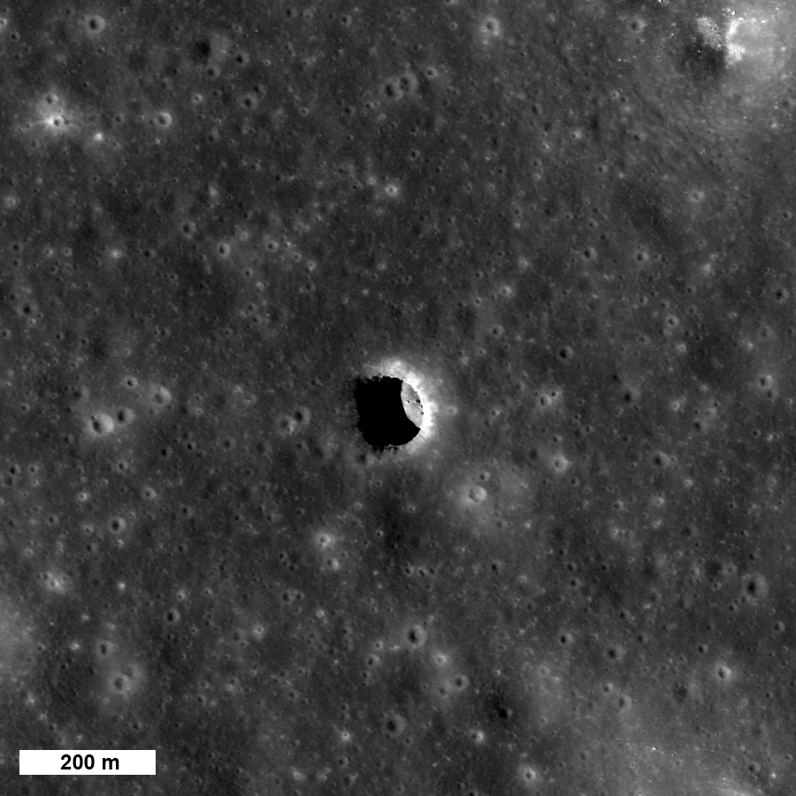
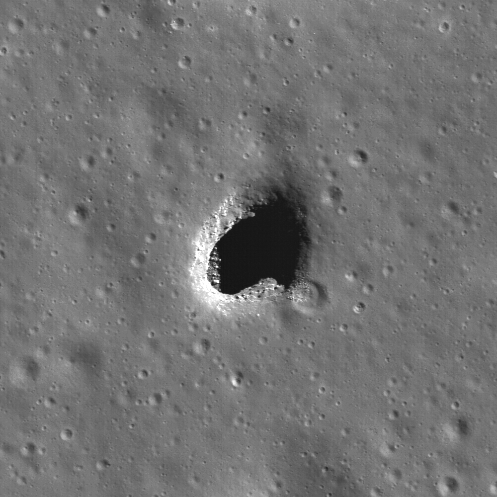
Impact craters are visible everywhere on the Moon, but pits are rare. This pit in Mare Ingenii (35.95°S, 166.06°E) is about 130 meters in diameter! Image width is 220 meters, illumination is from the upper right, NAC M128202846LE [NASA/GSFC/Arizona State University].

Lillian Ostrach
LROC News System

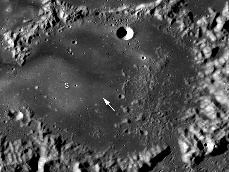
Mare Ingenii may be best known for its prominent lunar swirls, which are high albedo surface features associated with magnetic anomalies. However, lunar swirls are not the only unique geologic feature found in the farside "sea of cleverness". The high-resolution cameras aboard the Japanese SELENE/Kaguya spacecraft first discovered this irregularly-shaped hole, visible in the opening image at LROC's 0.55 m/pixel resolution. The boulders and debris resting on the floor of the pit are partially illuminated (left side of the pit, above image) and probably originated at the surface, falling through the pit opening during collapse.


Arrow indicates location of pit. "S" indicates one of the numerous lunar swirls located in this region. Portion of LROC WAC mosaic, 200 m/pixel resolution; image width is 160 km [NASA/GSFC/Arizona State University].

A pit in the Marius Hills region, previously discovered by the JAXA SELENE/Kaguya mission, is thought to be a skylight into a lava tube in the rille-riddled region. Similar to the Marius Hills pit, the pit in Mare Ingenii is probably the result of a partially collapsed lava tube. However, the numerous volcanic features of the Marius Hills (such as the prominent rilles and domes) are not found in Mare Ingenii - so how did this pit form? Future human exploration to this location would surely help scientists answer this question!

Peer into the depths of this exciting
LROC NAC frame
!

From Lunar Pioneer 3


As LRO approaches its first anniversary, perhaps the greatest accomplishment by the wide-ranging team operating the vehicle is the opportunity to relearn a lesson that continues to escape notice by many:

No understanding of Earth can be complete without a proper study of the Moon.

Above we see the sinkhole at Mare Ingenni (35.95°S, 166.06°E), one of three similar pits, holes or "caves" discovered on the Moon so far. It's not possible for us to improve on the LROC NAC M128202846LE frame, nor any other product produced by Dr. Marc Robinson and his team at Arizona State University. So we try, instead, to offer different perspectives. Hopefully this may inspire others to study the Moon also. Above, we trade a loss of resolution for a "closer" look at Ingenii Cave, and from a pilot's angle, putting a depth of field in the mind's eye. The obvious stratigraphy, just below the dusty surface, begs for a closer investigation. [NASA/GSFC/Arizona State University].

Tuesday, March 2, 2010

LROC: Haruyama Cavern in the Marius Hills


Enlargement of the Marius Hills Hole
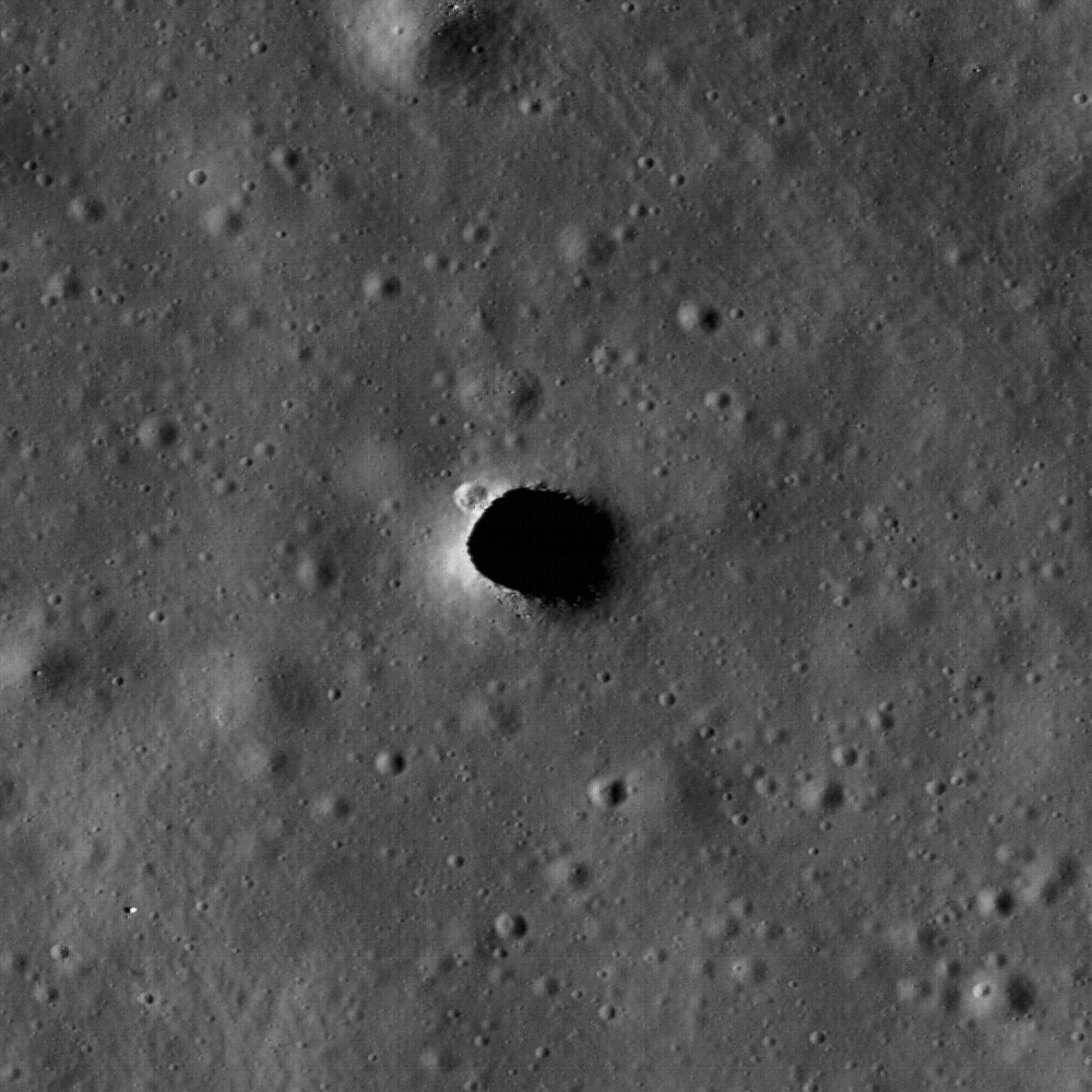
, or MHH, thought to be a collapsed roof and entrance to "Haruyama Cavern," unofficially nicknamed for the Japanese SELENE Terrain Camera investigation team leader who discovered it within the Marius Domes formation of Oceanus Procellarum. This new and closest look ever by NASA's LROC narrow angle camera reveals a small crater on the northwestern edge and small boulders on the southern lip of the hole, which is only around 65 meters in diameter. [LROC NAC M114328462R-NASA/GSFC/Arizona State University].


The Marius Hills Hole may access answers to morphological mysteries, revealing a new layer of this ancient volcanic region of the Moon called the Marius Hills, a formation familiar to observers of the Moon each time the long shadows of the terminator reveal many roughly 300 meter high domes named for the crater Marius to the east. Aristarchus Plateau is not far away to the north and Reiner Gamma swirl with its magnetic anomaly with its familiar bright complexity has a terminus here and meanders far to the southwest. The full LROC image was swept up December 1, 2009 during LRO orbit 1982, and has a resolution of one-half meter per pixel. The 2.5 kilometer width of M114328463R centers on 13.92°N, 303.21°E and shows a section of a sinuous rille with MHH opening into an underlying lava tube [NASA/GSFC/Arizona State University].

Carolyn van der Bogert
LROC News System

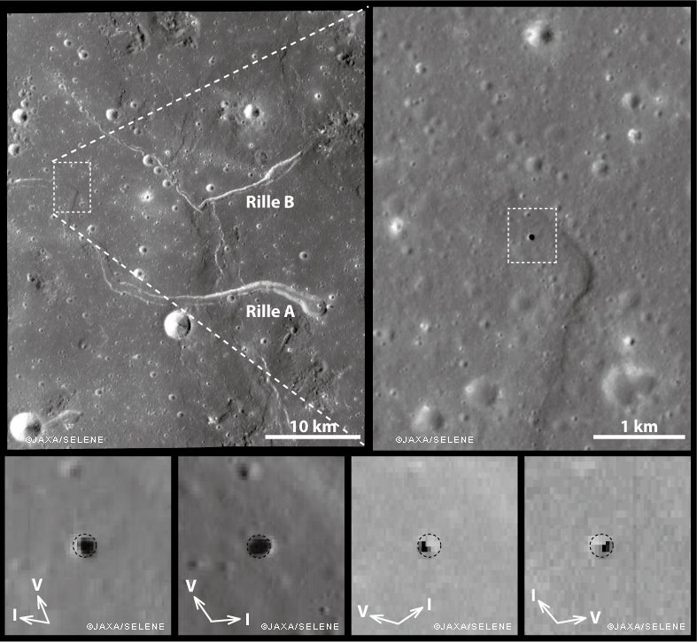
The Marius Hills hole was discovered in data from the Japanese SELENE/Kaguya Terrain Camera and Multiband Imager, and reported in Geophysical Research Letters. The Japanese team, led by Junichi Haruyama, made multiple observations of the hole using both the Terrain Camera and the Multiband Imager at resolutions as high as 6 meters/pixel (see below). The LROC image presented here (above), at 0.5 meters/pixel, is the highest resolution image of the Marius Hills hole to date! (The SELENE/Kaguya Terrain Camera team also made a fly-over movie of the hole, which is available on the JAXA website.)


Images of the Marius Hills Hole as observed under different solar illumination conditions by the SELENE/Kaguya Terrain Camera and Multiband Imager [JAXA/SELENE].

How did the Marius Hills hole form? The Marius Hills region was quite volcanically active in the past, and contains numerous volcanic features, including sinuous rilles. Sinuous rilles are long meandering channel features, like those labeled Rilles A and B in the above figure. Before the Apollo missions, sinuous rilles were thought to be formed by running water on the surface of the Moon! However, today we know that sinuous rilles form in two different ways: as open lava channels and/or as lava tubes, many of which subsequently collapse. Because the Marius Hills hole is in the middle of a sinuous rille, it likely represents a hole in the roof of a lava tube. The hole itself may have been caused by an impact that punched through the lava tube roof.

Lava tubes might be useful as locations for lunar bases (see a report by Fred Hörz of JSC here). The interiors of lava tubes could protect human explorers from different aspects of the lunar environment, including cosmic rays, meteorite impacts, and the extreme temperature differences between the lunar day and night. Just like caves on the Earth, lunar caves, including lava tubes, have temperatures that are constant.

Browse the entire LROC NAC image to explore the intriguing Marius Hills hole and its surroundings.

Friday, February 26, 2010

More cavern entrances discovered on the Moon

NEW DISCOVERIES OF LUNAR HOLES IN MARE TRANQUILLTATIS AND MARE INGENII. Junichi Haruyama1, Seiichi Hara2, Kazuyuki Hioki2, Tomokatsu Morota1, Yasuhiro Yokota1, Motomaro Shirao3, Harald Hiesinger4, Carolyn H. van der Bogert4, Hideaki Miyamoto5, Akira Iwasaki5, Makiko Ohtake1, Yoshifumi Saito1, Tsuneo Matsunaga6, Shunsuke Nakanotani7, Carle M. Pieters8, and Paul G. Lucey9, 1ISAS, JAXA, Japan (Haruya-ma.junichi@jaxa.jp), 2NTT DATA CCS CORPORATION, Japan, 3Taito-ku, Tokyo 111-0035, Japan, 4Westfälische Wilhelms-Universität, Germany, 5The University of Tokyo, Japan, 6NIES, Japan, 7Mitsubishi Space Software Co., Ltd., Japan, 8Brown University, USA, 9University of Hawaii, USA.

Introduction: We recently reported the discovery of a vertical hole on the Moon [1] in data acquired by the Terrain Camera (TC) and Multiband Imager (MI) on the Japanese lunar orbiter Selenological and Engineering Explorer (SELENE) [2], (nicknamed Kaguya). The 65 m-diameter hole is located at 303.3 °E, 14.2 °N in the Marius Hills region in Oceanus Procellarum on the near side of the Moon. The Marius Hills Hole (MHH) is probably a skylight in a lava tube. Here, we report the discovery of two additional nearly circular deep shafts.

Hole Search Methodology: SELENE TC and MI achieved almost 100% coverage of the Moon during the twenty-one month SELENE mission. To find vertical holes similar to MHH, we extracted the TC data of higher solar elevation angles (SEAs) of > 40° (Fig. 1). At these sun angles, the shadowed portions of these vertical shafts receive less sunlight reflected off of their walls than typical shallow lunar craters causing their shadows to be darker than typical craters. Be-cause TC’s sensitivity is very high, we can detect this difference. We searched for the lowest radiances in the data set and found two new holes in Mare Tranquillitatis and Mare Ingenii.

Mare Tranquillitatis Hole: The hole in Mare Tranquillitatis (MTH) is located at 33.2 °E, 8.3 °N (Fig. 1), 350 km from the Apollo 11 landing site. It is nearly twice the diameter of the MHH, and is roughly circular with a short axis length of 110 m (east-west) and a long axis length 120 m (north-south) (Fig. 2). The east rim is about 50 m higher than the west rim. MTH was observed eight times by TC and twice by MI. From the higher SEA data (49.6° in TC observations and 75.6° and 82.8° in MI), we estimate the hole to be 180m deep from the east rim. Unlike the Marius Hills Hole (MHH), MTH is not in or near a sinuous rille. There are numerous craters near MTH, but no other holes are present at the resolution of TC (10 m).

Mare Ingenii Hole: Using the same search for low radiance data, we discovered a hole in Mare Inge-nii (MIH) at 166.0 °E, 35.6 °S, near a prominent swirl feature on the far side of the Moon (Fig. 1). It has a slightly irregular shape (rounded triangle) with a long axis length of 140 m (east-west) and a short axis length of 110 m (north-south) (Fig. 3). Its northwest rim is a few tens of meters higher than the other portions of the rim. TC observed MIH six times and MI observed it once. Because we could not detect the bottom of MIH, even at the highest SEA (47.4° with TC), we can only place a lower limit on the depth of 90 meters. Like that in Mare Tranquillitatis, this hole is not located on or near a rille.

Interior Temperatures of Underlying Lava Tubes: The temperatures of these cavities are of interest for lunar resources and as special lunar microen-vironments. Based on a thermal equilibrium calculation for the shallow lunar interior, we estimated the temperature at the bottoms of the holes. For the surface albedos around the lunar holes, we used radiance data acquired by TC. Assuming a diffuse (Lambertian) sur-face, the albedos are 3.6%, for the surfaces around MHH, 3.7% around MTH, and 5.2% around MIH (Table 1). The interior temperatures of any lava tubes possibly connected to MHH, MTH, and MIH are estimated to be 18, 19, and 4 °C (Table 1). These tempera-tures may be overestimated because we used the radiance data obtained at SEA < style="font-weight: bold;">Table 1.


Hydrogen Accumulation in lava tubes exposed by skylights: The lunar surface is continuously showered by solar wind protons. Although a small fraction of the protons are implanted into the lunar surface, most pro-tons escape into space. However, the deep holes and their possible connected lava tubes might effectively trap solar wind protons. The surface ages surrounding MHH, MTH, and MIH are 3.5 Ga [1], 3.7 Ga [3], and 3.2 Ga [4]. If the holes opened simultaneously with or just after the formation of surrounding surfaces and the solar proton flux was similar to the current flux: 4 x 10(8)/cm2/sec [5], the integrated amount of the protons inside MHH, MIH, and MIH and their con-nected lava tubes would be 3 x 10(3), 1 x 10(4), and 9 x 10(3) tons, which correspond to water of 3 x 10(4), 9 x 10(4), and 8 x 10(4) tons (Table 2).


While these abundances are not entirely protected from loss, the vertical shafts and especially any connected lava tubes are protected from loss mechanisms such as sputtering and UV radiation, while preserving local low temperatures.

Observations By Other Missions: Although SELENE impacted on the Moon and ended its mission in June 2009, the Lunar Reconnaissance Orbiter (LRO) is currently observing the lunar surface with a variety of instruments. The observations acquired by LRO instruments will provide much additional information on these lunar holes. For example, the Lunar Reconnaissance Orbiter Camera (LROC) will reveal the detailed structure of the holes, Diviner can investigate the thermal conditions of the holes, and Chandrayaan and Change’1 data will also hopefully provide additional data for these holes. Of critical importance, is to investigate and understand the geological setting of each of the holes, to determine whether they are associated with lava tubes, like MHH, or have another origin.


Figure 1
. SELENE Terrain Camera observation coverage at solar elevation angles > 40°. Marius Hills Hole and newly dis-covered holes in Mare Tranquillitatis and Mare Ingenii are indicated by *1 (303.3 °E, 14.2 °N), *2(33.2 °E, 8.3 °N), and *3(35.6 °S, 166.0 °E).


Figure 2
. Enlarged TC images of Mare Tranquillitatis Hole, nearly circular with a short axis length of 110 m (east-west) and a long axis length 120 m (north-south).


Figure 3
. Enlarged TC images of Mare Ingenii Hole, a slightly irregular shape (rounded triangle) with a long axis length of 140 m (east-west) and a short axis of 110 m (north-south).


References: [1] Haruyama J. et al. (2009) GRL, 36, L21206, doi:10.1029/2009GL040635. [2] Haruyama J. et al. (2008) Earth Planets and Space, 60, 243-255. [3] Hiesinger H. et al. (2000), JGR, 105(E12), 29239-29276. [4] Haruyama J. et al. (2008) Science, 322, 938-939. [5] Starukhina L. V. and Shkuratov Y. G. (2000) Icarus 147, 585–587.