Showing posts with label Mini-SAR. Show all posts

Wednesday, February 26, 2014

You too, Yutu?

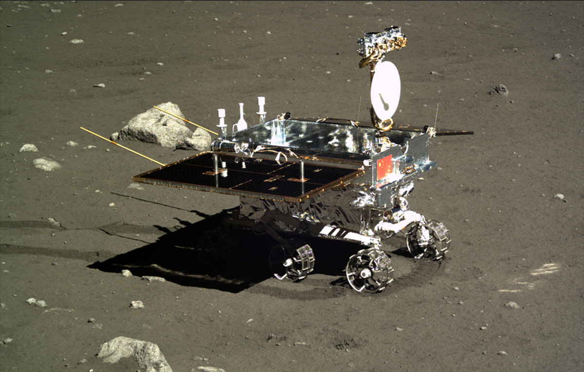
Jade Rabbit, "Yutu," the first lunar rover since Lunokhod-2 explored Le Monnier crater for the first half of 1973, in profile, as seen from the Chang'e-3 Panoramic Camera soon after deployment and its first tantalizingly brief trip across a few square meters of Mare Imbrium. The twin dipole antenna extending behind the vehicle are its ground-penetrating array [CAS/CNSA/CLEP].
Paul Spudis
The Once and Future Moon
Smithsonian Air & Space

Another lunar day has come and gone on the barren plains of Mare Imbrium.  How fares its most famous terrestrial inhabitant, the Chang’E 3 spacecraft and Jade Rabbit, the little Yutu rover?  The fact is, we really don’t know and those that presumably do aren’t talking about it much.

The Yutu rover of the Chang’E 3 mission has experienced some “mechanic control abnormality due to the complicated lunar surface,” is how the Chinese phrased the situation.  Details on the nature of the problem are impossible to come by, but one clear result is that the Yutu cannot move.  It apparently spent the last lunar day (which lasted from about 10 February until last weekend) sitting in one place.  For some scientific investigations, that is not necessarily a problem, but for Yutu’s primary scientific mission, it is fatal.

The goal of placing a rover on the Moon is to explore and examine multiple sites distant from each other.  Additionally, the traverse between stations enables unique experiments, such as profiling the surface – the principal objective of the ground-penetrating radar on China’s rover.  As the vehicle moves across the lunar surface, it emits radio waves of varying frequency into the surface.

Reflections from subsurface layers or boundaries are then received by the rover’s antenna, thereby allowing scientists to infer subsurface structure.  To get a subsurface profile, these measurements must be taken while the rover is moving.  Thus, an immobile rover makes this experiment impossible.

The rover’s other instruments operate during a stationary period.  However, once a chemical measurement has been made or an image taken, there is little value in continually repeating it.

If the Yutu rover is immobile, its scientific mission is effectively over.

News reports have stopped giving us data and information from the Chang’E 3 lander (which has a camera and an ultraviolet telescope) but assuming it is still operating, it may continue making observations.  The lander spacecraft made a panorama of the landing site, so that objective was completed.  Presumably, if the UV telescope is still operating, it can continue observing the sky but these observations are not significant to lunar science.

Three LROC NAC views of the Chang'e-3 landing site in north Mare Imbrium (44.1214°N, 340.4884°E, -2630 m elev.), before landing, after deploying the Yutu rover (south of the lander) and after Yutu was moved just to the southeast of the lander, where it apparently failed (and remains) reportedly following a ground-operations error during preparations ahead a long lunar night [NASA/GSFC/Arizona State University].
Thus, from the perspective of lunar science, it appears that the Chang’E 3’s Moon mission is over.

So, how did Yutu do as a lunar explorer?  For now, we really don’t know.  Aside from a few color images and a chemical spectra that was released to the press, little scientific data has been revealed (a Google translate version of a Chinese web page describing the Chang’E 3 science to date can be read HERE).  The data we have seen mostly show that the instruments were functioning.  We do not know how many measurements were made, what they have told us, or the geological setting of the chemical analyses.

The Chang’E 3 lander set down very near the rim of a crater 450 meters in diameter, a feature whose walls are littered with angular blocks clearly derived from the local bedrock. The fact that the Yutu did not make an immediate beeline over to those blocks for a detailed examination and chemical analysis tells me one of two things: either those planning the rover’s exploration traverse are not geologists or they didn’t get to it before the rover stopped working.

Yutu has led a famous existence in cyberspace, with numerous “tweets” to the world.  A public eager to anthropomorphize machines has responded in kind, including offering several admonitions to the rover to “pay attention to his wake-up calls.”  All this rhetorical cuteness hides the fact that China has been less than forthcoming about this mission, as they are about all of their space missions.  We hear only what they want us to hear.  Successes (of which they have had many) are widely trumpeted with blasts of publicity, while difficulties and failures are buried in silence.  It’s true that a space program run by the military (in the case of China, the People’s Liberation Army) will tend toward such an ethic.  But the WALL·E-like image promoted by China early in the mission is not the image conveyed by their current posture with the world press.

I find the Chinese attitude both interesting and dismaying.  It is similar to one that I experienced with Indian Space Research Organization (ISRO) during the Chandrayaan-1 lunar orbiter mission.  When the Chandrayaan spacecraft was running into difficulties after a few months in lunar orbit, the organizational instinct was to deny any problems and be less than forthcoming with the press about the status of the spacecraft.

Spaceflight is inherently difficult and things break all the time.  It is beyond ridiculous to cover up a problem by pretending that it doesn’t exist.  Similar behavior patterns characterized the early Soviet space program, in which we never heard about mission failures, but successes were given widespread publicity.  It seems that to date, China is adhering to that model.

There has been much in the media about the non-welcoming posture of some towards engagement and possible cooperation with China in space – admonishing Congress and NASA to be open to cooperating with China on future space missions.  There may come a time when this is possible but for now, it seems that reality is far away.

Dr. Paul D. Spudis is a senior staff scientist at the Lunar and Planetary Institute in Houston. This column was originally published by Smithsonian Air & Space, and his website can be found at www.spudislunarresources.com. The opinions he expressed here are his own, and these are better informed than most.

Related Posts:
It's not bragging if you do it (December 9, 2013)
China's Long March to the Moon (January 14, 2012)

Sunday, August 8, 2010

LRO Mini-RF spends month mapping lunar poles


The Mini-RF radar instrument on-board the Lunar Reconnaissance Orbiter has just completed its first month of systematic polar mapping. These mosaics cover from 70° to the pole for both the north (top) and south (bottom) polar regions. The left-hand images show radar brightness whilst the right-hand color images also show the circular polarization ratio. These data will be analyzed to search for ice deposits in the floors of the permanently shadowed craters, as well as to learn more about the impact cratering process on the Moon.


In this close-up of the full-size mosaic released by NASA August 7, most of the resolution is drained of the very granularity investigators are looking for, and have found at these highest northern latitudes, indications of changes in the polarity of radar signals returned to the spacecraft consistent with, among very few other things, hydrogen in a bound state with oxygen, as frozen water. Lost in this hazy reproduction also is a small crater singled last month showing a exceptionally strong indication. (See Potentially ice-rich' crater in Rozhdestvenskiy, Friday, July 2, 2010).

Familiar relief is obscured in Mini-RF (and in representations of data returned by the somewhat less sensitive but proven valuable Mini-SAR instrument flown on India's Chandrayaan-1), but the information obtained is like nothing else. Mapping and narrowing the possible composition of the lunar surface must be an exceptionally interesting study in images not yet available to the public [NASA/GSFC].


This nighttime temperature map, shown for reference, assembled from LRO Diviner data closely matches the field of view further up. (Left center, along the western interior of Hermite is an area unseen until LRO, within a permanently shadowed region now known to host the coldest temperatures yet detected in the entire solar system, during long lunar night only 25 degrees K.) [NASA/GSFC]

Friday, July 2, 2010

'Potentially ice-rich' crater in Rozhdestvenskiy

NASA Radar returns first high-resolution view of an unusual crater near Moon’s north pole

Investigators for Mini-RF, the synthetic aperture radar on-board NASA’s Lunar Reconnaissance Orbiter (LRO), recently imaged a potentially ice-rich crater near the north pole of the Moon.

Located at 85°N, 193.4°E, this permanently shadowed crater, about 8 km in diameter, is on the floor of the larger, more degraded 177 km Rozhdestvenskiy. With no sunlight to warm the crater floor and walls, ice brought to the Moon by comets or formed through interactions with solar wind appears to have collected there.


The crater was first identified as a region of interest during India's (ISRO) Chandrayaan-1 mission in2009, when it was seen to exhibit unusual radar properties consistent with the presence of ice.

With a resolution 10x better than the radar aboard Chandrayaan-1, LRO's Mini-RF allows NASA to see details of the crater’s interior.

In particular the circular polarization ratio (CPR) measures polarization characteristics of radar echoes, which give clues to the nature of the surface materials.

The inset figure shows a colorized CPR image of the crater. Red pixels have CPR values greater than 1.2. The CPR values inside the crater are almost all greater than 1, while CPR values outside the crater are generally low (much less than 1).

Regions with CPR greater than 1 are relatively rare in nature, but are commonly seen in regions with thick deposits of ice, such as Martian polar caps or the icy Galilean satellites. These are also seen in rough, blocky ejecta around fresh, young craters but in that occurrence scientists also observe high CPR outside the crater rim.

This crater has high CPR inside but low CPR outside. The Mini-RF team plans to examine data from the other LRO instruments, particularly temperature and topographic measurements, to better characterize the environment and setting of these unusual features near the poles of the Moon.

Global context map (Virtual Moon Atlas v.4) shows the location of recently noted lunar north pole craters. Nearby, permanently shadowed region (PSR) within Hermite may feature the coldest temperatures yet recorded in the entire Solar System. Goldshmidt, at a relatively lower latitude, has demonstrated a unusually high water signature in daylight.

Tuesday, June 15, 2010

LOLA: Moscoviense


Mare Moscoviense (GSFC - LOLA Image of the Week, June 14, 2010) is one of the few large maria located on the far side of the Moon.

LOLA data reveal the lowest point inside Titov crater to be about 2.7 km below the lunar datum. In contrast, the highest point on the rim of the basin rests about 3 km above lunar datum.

The total relief for the basin surrounding Mare Moscoviense is 5.7km. Although there are just as many impact basins on the lunar far side as the near, the extensive lunar volcanism seen on the near side is lacking on the far side of the Moon [NASA/GSFC/LOLA].


The spectacular Moscoviense Terrain Camera image from 2008, returned by Japan's first lunar orbiter Kaguya (SELENE-1). The yellow arrow indicates the location of a new and distinct kind of lunar rock discovered from data returned by India's first lunar orbiter Chandrayaan-1. The story from April 12 can be read here [JAXA/SELENE].


Figure 2, LROC News System Featured Image, January 8, 2010. LROC Wide Angle Camera color (Red=689, Green=566, Blue=415 nm) mosaic, with the location of the proposed Constellation Region of Interest (ROI) indicated with arrow [NASA/GSFC/Arizona State University].


Looking east over the Moscoviense Constellation ROI, LROC WAC M103531211, overlaid with LROC Narrow-Angle Camera image M105887165, atop the improving resolution of the lunar far side elevation map available in Google Moon. The arrow on the WAC image released by LROC is not completely covered, left center [NASA/GSFC/Arizona State University].


Stepping back from the false-color data in the LOLA Image of the Week, at the top, "bright is equal to relative height" in this look at Moscoviense in the global-scale, low-resolution LOLA data available through the Planetary Data System. Titov is just visible, and unlike visible imagery of the area, the multi-ringed nature of this impact basin is clearly visible along with a strong indication that the original inner ring may have been partially inundated with intrusive molten material, probably from within the Moon after it's original formation The obliquity of the "impact-forming event," retained in its present 'rectangular' shape also appears to have been a part of the formation from the instant it formed [NASA/GSFC/LOLA].

Some other postings related to Moscoviense:

Far Side was volcanically active
until 2.5 billion years ago

June 13, 2009

Far Side borderland landing site
October 6, 2009

Mare Moscoviense Constellation Landing Site
January 8, 2010

New spinel-rich lunar rock type
April 12, 2010

Thursday, March 18, 2010

The Multiplying Mystery of Moonwater


Moonwater. Look it up. You won't find it. It's not in the dictionary.

That's because we thought, until recently, that the Moon was just about the driest place in the solar system. Then reports of moonwater started "pouring" in – starting with estimates of scant amounts on the lunar surface, then gallons in a single crater, and now 600 million metric tons distributed among 40 craters near the lunar north pole.

"We thought we understood the Moon, but we don't," says Paul Spudis of the Lunar and Planetary Institute. "It's clear now that water exists up there in a variety of concentrations and geologic settings. And who'd have thought that today we'd be pondering the Moon's hydrosphere?"

Spudis is principal investigator of NASA's Mini-SAR team – the group with the latest and greatest moonwater "strike." Their instrument, a radar probe on India's Chandrayaan-1, found 40 craters each containing water ice at least 2 meters deep.

Right: A Mini-SAR radar map of the lunar north pole. Craters circled in green are believed to contain significant deposits of frozen water. [more]

"If you converted those craters' water into rocket fuel, you'd have enough fuel to launch the equivalent of one space shuttle per day for more than 2000 years. But our observations are just a part of an even more tantalizing story about what's going on up on the Moon."

It's the story of a lunar water cycle, and it's based on the seemingly disparate – but perhaps connectable – results from Mini-SAR and NASA's recent LCROSS mission and Moon Mineralogy Mapper (M3 or "M-cubed") instrument also on Chandrayaan-1.

"So far we've found three types of moonwater," says Spudis. "We have Mini-SAR's thick lenses of nearly pure crater ice, LCROSS's fluffy mix of ice crystals and dirt, and M-cube's thin layer that comes and goes all across the surface of the Moon."

Read the full feature HERE.

Tuesday, March 9, 2010

Water on the Moon "path-breaking" says Nair

G. Madhavan Nair (left), former chairman of ISRO,and M. Venugopalan, managing director and CEO of Federal Bank, at the Hormis memorial lecture in the city on Thursday [Vipin Chandran - The Hindu]

The confirmation of the presence of water on the moon by Chandrayaan-I probes will open vast opportunities for space research, says G. Madhavan Nair, former chief of the Indian Space Research Organisation (ISRO).

For one thing, water available on the moon could be split into oxygen and hydrogen using sunlight and the oxygen could be used by human explorers while the hydrogen could be used as fuel.

This could reduce the necessity to carry expensive payloads of oxygen and fuel by future space missions. This could drastically cut the cost of space research. At present, every kilogram of payload cost $50,000, thus making space explorations prohibitively expensive.

“It is a path-breaking finding,” Mr. Nair, who was at the helm of the Chandrayaan-I project, said in his K.P. Hormis Memorial Lecture here on Thursday. “It is one of the greatest findings from the space exploration.” (NASA had early this week announced that its radar onboard India's lunar orbiter Chandrayaan-I had detected vast ice deposits near the moon's north pole.)

Read the article in The Hindu, HERE.

Tuesday, March 2, 2010

600 million metric tons of water ice at Moon's North Pole confirmed in data from NASA Mini-SAR, flown on India's Chandrayaan-1


In this study of data from NASA's Mini-SAR flown on India's Chandrayaan-1 (and on LRO as the Mini-RF) high-reflectivity due to the coarseness typical of fresh craters has been circled in Red. Craters showing reflectivity anomalous of low-weathering (using methods discussed by Dr. Spudis here) are now believed to be indicative of water of remarkable purity measured in meters [NASA/ISRO].

Katherine Trinidad
NASA HQ


Using data from a NASA radar that flew aboard India's Chandrayaan-1 spacecraft, scientists have detected ice deposits near the moon's north pole. NASA's Mini-SAR instrument, a lightweight, synthetic aperture radar, found more than 40 small craters with water ice. The craters range in size from 1 to 9 miles (2 to 15 km) in diameter. Although the total amount of ice depends on its thickness in each crater, it's estimated there could be at least 1.3 trillion pounds (600 million metric tons) of water ice.

"The emerging picture from the multiple measurements and resulting data of the instruments on lunar missions indicates that water creation, migration, deposition and retention are occurring on the moon," said Paul Spudis, principal investigator of the Mini-SAR experiment at the Lunar and Planetary Institute in Houston. "The new discoveries show the moon is an even more interesting and attractive scientific, exploration and operational destination than people had previously thought."

During the past year, the Mini-SAR mapped the moon's permanently-shadowed polar craters that aren't visible from Earth. The radar uses the polarization properties of reflected radio waves to characterize surface properties. Results from the mapping showed deposits having radar characteristics similar to ice.

"After analyzing the data, our science team determined a strong indication of water ice, a finding which will give future missions a new target to further explore and exploit," said Jason Crusan, program executive for the Mini-RF Program for NASA's Space Operations Mission Directorate in Washington.

The Mini-SAR's findings are being published in the journal Geophysical Research Letters. The results are consistent with recent findings of other NASA instruments and add to the growing scientific understanding of the multiple forms of water found on the moon. The agency's Moon Mineralogy Mapper discovered water molecules in the moon's polar regions, while water vapor was detected by NASA's Lunar Crater Observation and Sensing Satellite, or LCROSS.

Mini-SAR and Moon Mineralogy Mapper are two of 11 instruments on the Indian Space Research Organization's Chandrayaan-1. The Applied Physics Laboratory in Laurel, Md., performed the final integration and testing on Mini-SAR. It was developed and built by the Naval Air Warfare Center in China Lake, Calif., and several other commercial and government contributors.

For more information about NASA's Mini-SAR, also known as Mini-RF, visit: http://www.nasa.gov/mini-rf

Thursday, August 20, 2009

LRO & Chandrayaan to team up, Aug. 20

Nancy Atkinson
Universe Today
NASA's Lunar Reconnaissance Orbiter (LRO) and India's Chandrayaan-1 will team up on August 20 to perform a Bi-Static radar experiment to search for water ice in a crater on the Moon's north pole.

Both spacecraft will be in close proximity, approximately 200 km above the lunar surface, and both are equipped with radar instruments. The two instruments will look at the same location from different angles. Chandrayaan's radar will transmit a signal to be reflected off the interior of Erlanger crater and then received by LRO.

Scientists will then compare the signal that bounces straight back to Chandrayaan with the signal from a slightly different angle received by LRO and assemble unique information, particularly about any water ice that may be present inside Erlanger.

Both spacecraft are equipped with a NASA Miniature Radio Frequency (RF) instrument that functions as a Synthetic Aperture Radar (SAR), known as Mini-SAR on Chandrayaan-1 and Mini-RF on LRO.

Read the full story HERE.

Tuesday, July 14, 2009

Tandem radar searches for lunar ice

With the Mini-RF instrument, a synthetic aperture radar flying aboard NASA’s Lunar Reconnaissance Orbiter, or LRO, the space agency now has two powerful tools searching for ice on the moon.

This week operators powered up and began preparing Mini-RF (Miniature Radio Frequency) for its primary mission, to create detailed images of the moon’s darkest areas, scan the lunar surface for hints of water ice and demonstrate new communications technologies.

LRO, launched June 18 from Cape Canaveral Air Force Station, Fla., and reached the moon June 25. Its seven science instruments now are being checked out and brought online.

The LRO Mini-RF is a version of the radar already circling the moon on the Indian Space Research Organization’s Chandrayaan-1 spacecraft. Since Chandrayaan-1 orbital operations began in late 2008, its Mini-RF, also known as Mini-SAR (Synthetic Aperture Radar), has mapped about 80 percent of both of the moon’s poles and provided images of areas never seen from Earth. Its second imaging period is set to begin in mid-August, opening the possibility of unique, joint measurements between Chandrayaan-1 and LRO that would enhance the hunt for ice.

“The Mini-RF team has reached a significant milestone, two payloads now in operation at the moon, “says Jason Crusan, program executive for the Mini-RF program, from NASA’s Space Operations Mission Directorate, Washington, D.C. “Having two very complementary instruments orbiting the moon on two different spacecraft shows how truly international the exploration of the moon can be.”

Mini-RF sends radio pulses to the moon from the orbiting spacecraft and then precisely records the radio echoes that bounce back from the surface, along with their timing and frequency. From these data scientists can build images of the moon that not only show the terrain in areas they otherwise couldn’t see, such as the permanently-shadowed areas near the lunar poles, but also contain information on the physical nature of the terrain.

“We’re uncovering the moon’s coldest, darkest regions, looking into craters and at other mysterious areas that never receive sunlight, yet preserve materials from the solar system’s earliest days,” says Ben Bussey, Mini-RF deputy principal investigator from the Johns Hopkins University Applied Physics Laboratory (APL) in Laurel, Md. “The exploration potential of these regions is also significant, since any ice deposits we locate would be valuable to future human lunar explorers.”

The Mini-RF instruments were designed, built and tested by a team from across the United States. APL hosts the operations center and performed the final integration and testing on both instruments. They were developed and built by the Naval Air Warfare Center and several other commercial and government contributors, including Sandia National Laboratories, Raytheon, Northrop Grumman and BAE Systems. Instrument principal investigators Stewart Nozette (LRO) and Paul Spudis (Chandrayaan-1) are from the Universities Space Research Association’s Lunar and Planetary Institute. NASA’s Space Operations Mission Directorate, NASA Headquarters, manages the Mini-RF program.

Wednesday, April 1, 2009

Spudis: Chandrayaan Mini-SAR near completion of first mapping cycle

Rozhdestvensky K, near the north pole of the Moon

Air and Space - Smithsonian - Paul Spudis

"The initial images look very clean, with a few collection artifacts and some missed orbits. Some of the mosaics have mismatched, offset features, not because of any fault in the instrument but because we still do not have a precise global cartographic control net for the Moon, a missing data set that will be filled by the mapping currently taking place by Chandrayaan, the Japanese Kaguya, the Chinese Chang’E and soon, the American Lunar Reconnaissance Orbiter missions. Much of the shadowed terrain covered by Mini-SAR shows a surface much like the surface of the Moon not in shadow, with small craters of a variety of shapes and sizes present. Some images show spectacular surface features, including wall slumping, central peaks and flat, smooth floors."

"A particularly interesting and unusual feature was imaged by Mini-SAR almost by accident. Because of a timing error, we started a few mapping passes of the south pole early, before the scheduled start at 80° south latitude. Good thing we did! We covered the fresh, spectacular Schrödinger impact basin, on the lunar far side. Schrödinger shows an unusual, keyhole-shaped crater along a long fissure on the basin floor. This crater is surrounded by optically dark material, which has been interpreted as volcanic ash deposits. The new Mini-SAR image shows that this material is also dark in radar reflectivity, exactly what would be expected from a fine-grained, block-free deposit. Thus, our radar images confirm the geological interpretation first derived in 1994 from Clementine images."

Read Paul Spudis' report for Smithsonian HERE.

Friday, February 13, 2009

Mini-SAR imaging radar on the Chandrayaan-1

In carefully threading through the much anticipated and voluminous abstracts and presentations listed on the program for next month's Lunar & Planetary Science Conference XL (2009), as one might expect, there is much new from investigators for Japan's Kaguya and India's Chandrayaan 1 lunar orbiter missions, and much else besides.

Veteran PI Paul Spudis is the natural lead author of Abstract 1098, The Mini-SAR imaging radar on the Chandrayaan-1 Mission to the Moon, a presentation listed on the first of two full sessions devoted to science from those two missions along with China's Chang'E 1.

Because the abstracts for the presentations, posters and "print-only" studies are now on-line, we proceed with our own presentation of selected highlights from the conference schedule, hoping to draw your attention to this, the 40th annual LPSC since 1969 alone with the good science we anticipate will be unveiled there.

Chandrayaan's Mini-SAR is primarily an American contribution to India's mission, with contributed oversight from the LPS Institute itself, Johns Hopkins' Applied Physics Laboratory, the National Radio Astronomical Observatory (NRAO) in Socorro, NASM in Washington, DC, the University of Hawaii at Honolulu, ISRO and JPL.

"The possible existence of ice in the polar cold traps of the Moon continues to be debated. Clementine conducted a bistatic radar experiment in 1994, which supported the idea of an ice deposit within Shackleton crater near the south pole. However this result generated controversy and there is still disagreement whether the observed polarization anomalies are due to ice."

"However there is little argument related to the discovery by Lunar Prospector of enhanced hydrogen levels in the polar regions. The question is whether this hydrogen is in the form of water ice (or hydrogen). By determining the backscatter properties inside the dark areas near the poles we will constrain the nature and occurrence of water ice deposits on the Moon."

"While no remote measurement can definitively answer the question of whether ice exists at the lunar poles, an orbiting SAR provides the most robust method of obtaining a positive indication of ice deposits. With an orbital SAR, ALL areas on the Moon can be seen. The 6° inclination of the Moon’s orbital plane around the Earth means that large areas of permanent shadow that might contain water ice can never be seen from Earth and all polar areas that can be seen from Earth are viewed at high incidence angles, which reduces the coherent backscatter predicted for ice deposits. However all permanently shadowed regions will be imaged multiple times by an orbiting radar with incidence angles favorable for determining their scattering properties."

"Mini-SAR uses S-band (2380 MHz), has an illumination incidence angle of 35°, and image strips have spatial resolution of 75 meters per pixel. During the observation opportunities given to the instrument, it will image in SAR mode both poles every 2-hr orbit, covering both polar regions in a single 28-day mapping window."

Read LPSC XL #1098 HERE.

Saturday, January 17, 2009

Chandrayaan eyes ice on moon


From Charles Wood, and his indispensable LPOD, "One of the biggest scientific puzzles today is whether ice exists in the permanently shadowed craters at the lunar poles. The Chandrayaan-1 lunar orbiter and the forthcoming Lunar Reconnaissance Orbiter both carry a small radar (Mini RF) that will beam pulses of energy into these dark craters to image their floors and make measurements of their physical characteristics. The first results of this radar imaging have just been released, showing a swath over the south polar crater Haworth. The NASA release says the swath is 50 by 18 km, but the scale bar indicates 42 by 7 km. The release is also titled NASA Radar Provides First Look Inside Moon’s Shadowed Craters but the Kaguya ultra-sensitive Terrain Camera successfully imaged the forever-dark floor of Shackleton crater last year. The Mini-RF doesn't reveal anything unusual about the floor of Haworth - it has a number of small impact craters that will permit an estimate of its age. If they give an old age (a few billion years) their relatively sharp edges argue against slow accumulated of ice from comet impacts. And each place where a crater occurs would evaporate and deplete any ice that might have existed. The radar has also determined that the interior of a small, dark-shrouded crater near Shakleton has a real hard surface, different than other surfaces pinged so far; perhaps consistent with ice. These radar images were collected in November; presumably many more are now available - formal interpretation is promised for January 29."

Manoj K Das
Beta 1.0 Express Buzz

Kochi - In what could be a very significant scientific breakthrough, Indian and global space agencies onboard Chandrayaan are waiting with bated breath for a final confirmation of the presence of ice at the lunar poles.

This week India will move Chandrayaan to take a second and closer look into the depths of a small crater on the south pole to confirm the presence of ice after the initial inference of data suggested a strong possibility of this.

Sources told to The New Indian Express that Chandrayaan payloads detected the presence of ‘real hard surface’ inside a small crater sitting next to the Shackleton Crater. Payloads of ISRO and NASA have recorded this unique feature.

But it is too early to conclude that it may be a sheet of ice, sources said. “Such hard surface is very uncharacteristic of the lunar surface. The moon’s upper crust is very dusty. Though the dust percentage would be proportionately reduced inside the crater, the possibility of such a hard crust is food for thought,” they said.

The suspected presence of ice was first detected by an S-band radar that can look into dark abysses where sunlight doesn’t reach. The S-band rays reflect from targets and onboard computers analyse the feedback.

“A couple of instruments on Chandrayaan have given the same inference.

The satellite will be made to focus on the crater once again. This is to verify the first input. The data will be calibrated and cross-checked with input received from other payloads,” sources said.

The presence of ice will give a tremendous boost to global efforts to use the moon as a prospective transit point for inter-planetary missions and future habitat. Apart from iron, the Chandrayaan has detected the presence of magnesium on the lunar surface. But concrete information regarding the presence of Helium-3, the much-sought-after gas considered to be a potential source of power generation, is yet to be recorded.

“There is so much data pouring in every day. This needs to be analysed and translated into scientific information,” sources said. The ISRO is planning a total review of the Chandrayaan data in the third week of this month.

Sources said all partner agencies would take part in the first review meet scheduled for January 29 when a formal announcement of materials detected till date is expected to be made.