Showing posts with label SMART-1. Show all posts

Friday, January 31, 2014

ESA on Yutu, as controllers wait for sunrise, February 9

Yutu
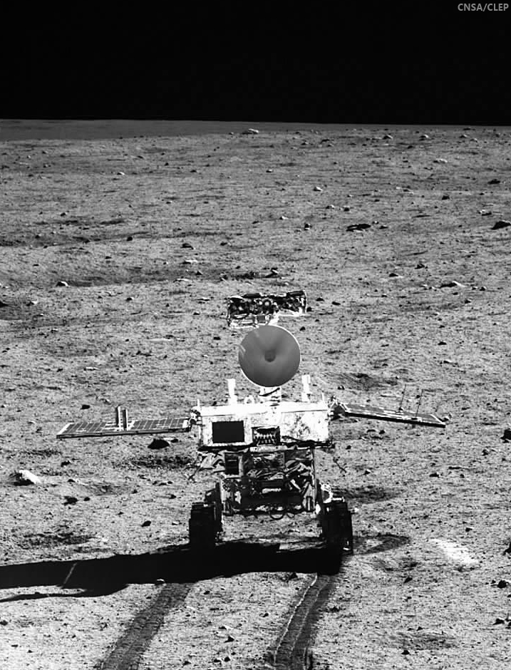
Song of Yutu. China News reported panorama photographs of the Chang'e-3 lander captured by Yutu and corresponding images of the Jade Rabbit rover from the lander, prior to the end of their second 330 hour-long lunar day, January 25, were the final such complimentary photographs of the mission [CAS/CNSA/CLEP].
Professor Bernard H. Foing
Bernard Foing
Executive Director
International Lunar Exploration Working Group (ILEWG).

ESA SMART-1 Project scientist

The Chang'e3 lander and Yutu rover achieved impressive results in their first lunar day on the surface, where temperatures are over 90°C (194°F) at midday. After their first lunar night, which is extreme, with temperatures dropping to -180°C (-292°F), they spectacularly woke up and resumed operations after January 12.

This was already an achievement considering the very difficult thermal conditions and surface environment on the Moon. Already with our SMART-1 (2003) spacecraft orbiting the Moon we had to solve thermal problems, but it is much more difficult for a rover on the surface.

Unofficial information mentions a mechanical problem during the withdrawal of a solar panel on rover Yutu prior to sleep on January 25 for the second night. This could affect the electronic box and a few instruments on the rover mast.

Operations of the Chang'e-3 lander instruments would not be affected.

1. Is it likely that lunar dust caused a mechanical failure, meaning the rover could not hibernate?  It is not established that dust is the culprit at this stage. The high thermal extremes from day to night (from 90° to –180°C, or 194° to -292°F) can also certainly put a huge stress and fatigue on mechanical systems.

2. What can be done to protect future rovers from lunar dust?  Already measures are being taken by rover designers to avoid dust entering sensitive mechanical gear or depositing on optical surfaces. However lunar dust can be electrostatically charged and can stick on sensitive parts.

3. Is Yutu no longer operational, or could it be fixed?  Our Chang’e 3 and Yutu colleagues can be praised for what they have achieved so far. I am sure that they are not going to give up. They are analyzing, in depth, the problem and are working hard to assess safe recovery strategies.

4. How will this failure restrict the remaining mission?  The lander went nominally to sleep (January 25). The Yutu rover sent an emotional farewell message before hibernating. For the Yutu rover we have to hope and wait for the next lunar morning (around February 9) to assess the situation. Best wishes from all of us to the Yutu lunar Jade Rabbit.

We wish the teams and Change3 Yutu good luck and success for further operations. Lunar exploration is difficult, but these technical challenges bring progress for future lunar and planetary missions and even for applications in space and on Earth.

Related Posts:
Problem with solar-powered Yutu rover before nightfall (January 25, 2014)
Chang'e begins long-term science mission (January 18, 2014)
Preliminary Science Results from Chang'e-3 (January 16, 2014)
Chang'e-3 and Yutu survive first lunar night (January 14, 2014)
Chang'e-3 APXS delivers its first surface analysis (January 1, 2014)
Chang'e-3 lander and Yutu rover from LRO (December 31, 2013)
6 of 8 Chang'e-3 science instruments now active (December 18, 2013)
LRO: Finding Chang'e-3 (December 15, 2013)
China's Jade Rabbit, it's time in the Sun (December 15, 2013)
Chang'e-3 Landing Site in Mare Imbrium (December 15, 2013)
Jade Rabbit successfully deployed to the lunar surface (December 14, 2013)
It's not bragging if you do it (December 9, 2013)
"Lunar Aspirations" - Beijing Review (December 9, 2013)
Chang'e-3 safely inserted into lunar orbit (December 6, 2013)
CCTV: Chang'e-3, launch past TLO to Earthview (December 2, 2013)
Chang'e-3 launched from Xichang (December 1, 2013)
Chang'e-3 launch window opens 1 December 1730 UT (November 29, 2013)
Helping China to the Moon, ESA (November 29, 2013)
'Government Penalty' removed from Google Lunar XPRIZE terms (November 7, 2013)
Chang'e-3 and LADEE: The Role of Serendipity (October 31, 2013)
Outstanding animation celebrates China's Chang'e-3 (October 29, 2013)
LROC updates image tally of human artifacts on the Moon (September 25, 2013)
Chang'e-3: China's rover mission (May 4, 2013)
China's grand plan for lunar exploration (October 11, 2012)
ILOA to study deep space from Chang'e-3 (September 11, 2012)
China's Long March to the Moon (January 14, 2012)
China plans lunar research base (May 11, 2011)
PRC continues methodical program (March 8, 2011)
Chang'e-2 arrives in mission orbit (October 9, 2010)
Dispatch from Chang'e-2: Sinus Iridum (October 4, 2010)
Chang'e-2 takes direct approach (October 1, 2010)
Chang'e-2 sets stage for future lunar missions (September 3, 2010)
Chang'e-1 research reported published (July 22, 2010)
Chandrayaan-1 goes silent (August 29, 2009)

Thursday, September 17, 2009

Remembering SMART-1

No particular reason. Awaiting the LRO First Light News Conference, on NASA-TV this afternoon, two things brought the European Space Agency's first lunar orbiter to mind. First, was SMART-1's contribution to "ESA Poster art of the space era, a colourful selection of posters and calendars illustrating the past three decades of ESA missions and programmes, and highlighting activities at ESOC, the European Space Operations Centre, Darmstadt, Germany." Take your choice of three pages of ESA-flavoured eye-candy, HERE.

And many of the presentations from the 2009 National Lunar Science Institute (NLSI) conference at NASA Ames last July have been uploaded, linked to this past summer's agenda. Among them lead investigator Bernard Foing's justifiably proud, "Synthesis of SMART-1 lunar results for future exploration." What an amazing spacecraft it was, too. If you want to see ultimate proof of European advances in miniature science, this mission showed weight is no hindrance to what is still state-of-the-art propulsion and remote sensing experiments. It's worth the download, but this adobe reader file is no light-weight, coming in at 140 mb.

Thursday, June 11, 2009

SMART-1 latest maps Kaguya lunar impact


Detail from SMART-1 AMIE mosaic

ESA - June 11, 2009 - Japan's lunar orbiter Kaguya yesterday concluded its successful scientific mission with a controlled impact on the lunar surface. The impact occurred at 16:25 UT (18:25 GMT) on the Moon's near side, close to the limb, at lunar coordinates ~80.4°E and ~65.5°S. The location and time made the impact visible from Earth's southern hemisphere, and one early result has already been reported from the AAT telescope in Australia.

Monday, June 8, 2009

Fine-tuning Kaguya's Impact


Dr. Bernard H. Foing, executive director of the European Space Agency's International Lunar Exploration Working Group (ILEWG) and project scientist for ESA's SMART-1 lunar orbiter is cautioning the larger community of astronomers and other observers that the Japanese orbiter Kaguya (SELENE 1) may come down earlier.

Others are less concerned. Jim Mosher, who has lead an online group rehearsing for the impact mission of LCROSS, now preparing for launch with the LRO, June 17, puts more faith in Kaguya flight directors at the Japanese space agency JAXA.

"The Japan lunar probe Kaguya, after a productive operational phase will conclude its scientific mission with a controlled impact on the lunar surface expected on June 10, 2009 at 18:30 GMT, on the Moon's Near Side, in a dark area at the eastern limb, lunar coordinates East 80, and South 64 degrees," Foing writes.

"The SMART-1 team has constructed mosaic maps of the Kaguya landing strip using survey images obtained by the SMART-1's AMIE camera." (Close up HERE.)

"The SMART-1 images shows the Kaguya final perilune orbits and impact site are within a very cratered ancient highland terrain. Because of the high topographic relief, will the spacecraft hit the Moon before the nominal time?"

“There is a possibility that the Kaguya impact would take place in fact about 2 or 4 hours before expected," writes Foing, "if the lunar crater rim indicated by SMART-1 is high enough to be on the way.

"Observers should be prepared for that."

“For SMART-1 we had to make a last small spacecraft maneuver just 3 days before impact”, wrote Foing, “in order to avoid a lunar crater rim and enforce the landing at the exact time we had announced, within the second."

“We have to analyze the lunar topography to determine the exact time of impact, and the slopes to determine whether the incidence will be grazing enough to have Kaguya bouncing on touchdown”, says Bernard Foing, “as was observed with SMART-1 hard landing. We hope that future data compared to SMART-1 maps will show the new elongated Kaguya crater and bouncing secondary debris.”

"You may, of course, have access to more current information than the general public," Mosher responded, but (as of this writing) the information on the Kaguya site is back to saying the impact is expected at 63°S, rather than 64°S, with an update expected at 01:00 UT on June 10.

"I believe that would put the impact on the north side of Gill D, rather than the south side that you are indicating on your attachments. (See the USGS map).

"It looks like the approach to the impact site will be from the south," Mosher wrote

(JAXA's Kaguya orbital tracker, HERE.) currently puts the spacecraft elevation at 0 km at 80.4°E/66.5°S at about 18:25 UT, and puts the spacecraft at 80.4°E/49.1°S (altitude -4 km) at 18:30 UT (the announced impact time).

"By suggesting Kaguya may hit the surface 2 or 4 hours earlier than announced, " Mosher wrote to Foing, "I presume you mean it may hit in the same general area on earlier orbits. Does this imply you think it may strike the crater or highland between Gill and Wexler U?"

See Map HERE.

"Finally, I notice the Kaguya team is soliciting observations by professional astronomers in their Jun. 5, 2009: Final operation week for KAGUYA" communication at, HERE.

"I have no idea if they have gotten any takers, nor what the expected magnitude of the flash may be, nor what the chances are that it might be hidden by terrain. As mentioned in an earlier post, there are unofficial finder charts for Earth-based observers available (HERE.)

"Perhaps JAXA will release better ones in their June 10th announcement at 01:00 UT?"

Friday, October 3, 2008

Taking A SMART Sidelong Look At Lunar Peak Of Eternal Light

Images taken by the AMIE camera carried by ESA’s SMART-1 mission have been used to create digital elevation model of the peak, which is almost continuously exposed to sunlight.

“AMIE is not a stereo camera, so producing a 3-D model of the surface has been a challenge,” said ESA's Dr. Detlef Koschny.

“We’ve used a technique where we use the brightness of reflected light to determine the slope and, by comparing several images, put together a model that produces a shadow pattern that matches those observed by SMART-1.”

AMIE took a total of 113 images of the peak, located close to the rim of the Shackleton Crater which lies on the lunar south pole. In all but four of the images, the peak was illuminated by sunlight.
Read more HERE.

Tuesday, April 1, 2008

European VSE

Europe and ESA have their own Vision for Space Exploration
Astrobiology Magazine interviews Bernard Foing

Lee Pullen
Foing describes the plan as a four stage program. First, using orbital precursor missions like SMART-1, robots map the Moon in detail and learn about lunar geology. The next part should come after 2010, when a variety of probes from different countries will be deployed on the surface, working in concert on various activities. After that, infrastructure and life-support systems will be constructed and visited for short periods by astronauts. The final stage will have outposts and a permanent human presence on the Moon.
These plans may seem ambitious, but international collaboration is contributing more than ever before. “We are offering some of our SMART-1 data to help other countries to prepare their missions,” explains Foing. “With our ESA ground stations, we are helping the Chinese to double the amount of data they are going to downlink with their Chang’e 1 mission.” These aren’t just one-way deals though, since data and equipment can be shared between all space agencies. The Chang’e 1 mission, Japan’s Selene-Kaguya, and the United State’s upcoming Lunar Reconnaissance Orbiter and LCROSS Impactor will all provide valuable data.
“We are looking at ways where we could exchange information and carry some instruments from other countries on our platform,” adds Foing. “Also, some of our European instruments can be carried onboard landers from international partners.”
Read more HERE.

Tuesday, March 11, 2008

New lunar south polar maps from SMART-1


Not to be outdone by NASA Goldstone Radar, ESA has released a mosaic of Lunar South Pole images that add to the appreciation of that region's true depths and heights recently unveiled.

In a matter of weeks, the public knows more about this ancient terrain of Earth's Moon than in fifty years of close ups, twice as cratered as the landing site of Apollo 15

ESA 11 March 2008
SMART-1’s Advanced Moon Imaging Experiment (AMIE) has collected many images of the lunar south-polar region, with unprecedented spatial resolution. The images, obtained over a full year of changing seasons were used to study the different levels of solar illumination on the Moon’s surface.

The orientation of the lunar rotation axis is such that the Sun just about grazes the lunar poles, leaving some regions permanently shadowed. Shackleton crater is located in the inner ring of the south pole Aitken basin, the largest known impact basin in the solar system. It has a diameter of 2600 km. The south pole is located on the rim of Shackleton crater.

SMART-1 took images around the crater, which is a strong contender for a future robotic and human exploration site and for a permanent human base. The polar mosaics show geological features of interest within reach from the south pole. Monitoring of the illumination of selected polar sites has allowed scientists to confirm that a ridge located 10 km from the Shackleton rim is prominently illuminated, and could be a strong contender for a potential future lunar outpost.

The large number of impact craters in the area indicates that the terrain is ancient. An example is crater Amundsen, 105 km in diameter, lying 100 km from the pole. It shows central peaks and asymmetric terraces that deserve geological and geochemistry studies.

Essentially more HERE.

Tuesday, March 4, 2008

I AM DISAPPOINTED: No LPOD, Today

Kaguya-Selene, Chang'e-1, SMART-1, etc., Where are the images?

"Apparently it is easier to send a rocket to the moon than to know what to do with the data..."

Chuck Wood
LPOD
For the first time since the nineties there are spacecraft orbiting the Moon, taking hundreds of thousands of images.

SMART-1 orbited from November 2004 to September 2006, and Japan's Kaguya (Selene) and China's Chang’e-1 have circled the Moon since October 2007 and November, 2007. But so few exciting new images and other data have been released that it is worth wondering why.

For SMART there are rumors that the imaging cameras didn't always work correctly, that there was no budget for archiving data, and that the imagery wasn't important since it was a technology demonstration mission. Whatever the reason SMART has released only 69 images and mosaics on the ESA website, even though maps of data acquisition suggest that many thousands of images were obtained.

Japan quickly released the breathtaking HDTV image of the lunar south pole and Earthrise. This seemed to presage a flood of extraordinary new data that would transform lunar science, but so far only 20-30 images have been released, and almost all are HDTV rather than from the higher resolution Terrain Camera and Multi-Band Imager. Japanese scientists are scheduled to present papers about Selene at the Lunar and Planetary Science Conference next week so perhaps there will be more wonderful images and science released then.

China was very proud of its Chang'e success, having the President of the country release the first image. But then ignorant bloggers in China and elsewhere claimed the image was copied from an American Clementine mosaic. China rightly defended the integrity of their image, but it took Emily Lakdawalla to clearly explain that it wasn't a fake.

I guess that China has been offended by the hallabaloo and surprised by the lack of praise and has subsequntly released only a handful of images. I think there has been another factor that has affected all three missions. In general, the images released have not been geologically significant, sometimes appearing to be selected at random, and the captions often have been naive.

Apparently it is easier to send a rocket to the Moon than to know what to do with the data. And there is one more thing these mission managers need to learn. There is vast public relations benefit from frequently releasing dramatic images to demonstrate the success of missions. This builds public support and pride, both necessary to move on to future missions. I hope ESA, Japan and China will more fully share their wonderful new data with the world.