Showing posts with label Luna 9. Show all posts

Wednesday, August 8, 2012

Scooping the Soviets

Luna 9's view of the lunar surface, the "unauthorized" version [Jodrell Bank Observatory].
Paul D. Spudis
The Once and Future Moon
Smithsonian Air & Space
  
Sir Bernard Lovell, the former Director of Britain’s Jodrell Bank Radio Observatory, died recently at the age of 98.  Lovell took the lead in establishing Jodrell Bank near Manchester – one of the world’s premier radio telescopes, a facility that played a lead part in the history of the early space age.  One of its most memorable episodes was its role in releasing the world’s first images taken from the surface of the Moon.

In late January 1966, the USSR launched the probe Luna 9 to the Moon.  The Soviets had tried to soft-land a spacecraft on the Moon several times previously.  Each attempt ended in failure.  The United States had the Surveyor project under development, but it had yet to see its first launch.  As was their custom, Jodrell Bank tracked the Luna 9 during its coast to the Moon, listening in on its telemetry signals and documenting the position and velocity of the probe throughout its flight.  On February 3, 1966, with an encounter speed of 6 meters/second (about 13 mph), the probe “crash-landed” on the lunar surface.  Signal transmission from the probe stopped abruptly.  The team at Jodrell Bank assumed that the mission was over, surmising that Luna 9 probably hit the Moon too hard or was designed as a crash lander.  Then to their astonishment, the probe began transmitting radio signals and the observatory recorded them, uncertain as to their meaning.

Lovell thought – suppose these signals were simply an ordinary telefax communication?  If these transmissions were pictures of the lunar surface, perhaps the signals the observatory recorded could be read by a commercial facsimile machine.  But Jodrell Bank Observatory had no such machine; the observatory was a scientific laboratory, which in those days displayed its received radio signals in the form of line graphs made by paper strip recorders.

Enter the power of the press!  The local office of the London Daily Express rushed a fax machine to the observatory where Lovell and his staff printed out the first picture of another planetary surface ever returned to Earth.  Because the staff of the observatory didn’t know anything about Luna 9’s encoding system design, they had to guess at the ratio of the horizontal to vertical dimensions of the image.  They guessed wrong.  The resulting image showed a jagged, rough peak-like surface, although apparently fine-grained. To both the chagrin and annoyance of the Soviet builders of Luna 9, surface images were released to the world press by the British observatory, leading to an amusing sequence of scientific “instant interpretation” that appeared in the press over the days that followed.

In the early days of lunar science, an intense debate raged over the geologic nature of the Moon.  Was it a cold, ancient body that had never undergone melting?  Chemist Harold Urey and Astronomer Thomas Gold thought so.  They postulated that the Moon was a giant, primitive chondrite meteorite, an unmodified piece of the early solar nebula that would tell us about the cold accretion of the planets.  Additionally, Gold was famous for his idea that the dark maria of the Moon were large “dustbowls” in which a heavy spacecraft would slowly sink like a body caught in quicksand on the Earth.

In contrast, many geologists and some astronomers thought otherwise – in their view, the Moon was a body shaped by internal melting, magmatic activity and volcanic eruptions.  These “hot moon” people saw evidence for volcanism in many lunar surface features, from the maria to craters.  Some, such as the founder of the field of planetary geology, Eugene Shoemaker, had a more nuanced viewpoint, ascribing both impact and volcanic origins to specific features, as appropriate.  Although the hard landing American Ranger spacecraft had transmitted high resolution video pictures before hitting the Moon, it did not survive the lunar impact and no one had seen a picture of the surface from a vehicle that landed softly enough to survive and long enough to send back a picture, until now.

A cascade of instant science followed the release of the Jodrell Bank images. Tommy Gold claimed that the pictures validated his dust bowl idea, even though it showed a fine-grained surface strewn with rocks (which Gold thought were clods of fine dust).  Gold also said that the Luna 9 capsule was slowly sinking into the surface (in accordance with his model, of course) and would soon sink out of sight.  Gerard Kuiper of the University of Arizona thought that the surface of the Moon was composed of bare, dust-free bedrock and so interpreted the new Luna 9 images thusly.  U.S. Geological Survey geologist Hal Masursky said that the image looked like the rough, clinkery surface of a jagged lava flow (a surface for which geologists give the Hawaiian name “aa”) and was clearly of volcanic origin.  An eager reporter pressed him:  this surface is volcanic – isn’t that where gold is sometimes found on Earth?  Hal distractedly nodded agreement, leading to the ludicrous headline that Luna 9 had found veins of gold on the Moon.

Alas, there was gold — scientific gold.  The distortion of the image caused by a wrong guess of the aspect ratio by the staff of Jodrell Bank soon was corrected when the Soviets released their own version of the image.  The lunar surface consists of fine-grained dust, smooth and undulating (because of the presence of a myriad of small surface craters), with the occasional rock lying about — no dust bowls, no bare bedrock, no “quicksand,” no aa lava flows, and no veins of gold.  The disappointment of the press was palpable.

The tendency of scientists to see confirmation of their own predispositions in the new data is striking.  We all are human, possessing the natural inclination to interpret new data in a way most favorable to our own long-held beliefs.  In this instance, a simple and excusable error in the reconstruction of the surface image led to abundant egg on the faces of most of the world’s experts on lunar science.  Instant science is often wrong at worst or incomplete at best.

Originally published at his Smithsonian Air & Space blog The Once and Future Moon, Dr. Spudis is a senior staff scientist at the Lunar and Planetary Institute. The opinions expressed are those of the author and are better informed than average.

Related Post:
"Boy that sure looks like Luna 9!" (December 3, 2011)

Saturday, December 3, 2011

"Boy, that sure looks like Luna 9!"

Fig. 1  Idealized Google Earth icon of Luna 9, the first soft-landing on the Moon (the first soft-landing anywhere other than Earth), February 3, 1966. The cartoon Russian spacecraft is pinpointed more than 30 kilometers northeast (8.0°N, 296.0°E) of an 'official' landing site (7.08°N, 295.63°E) because investigators say the 'official' coordinates place the lander well beyond the eastern rise, at left on the horizon above. That location doesn't appear to match the landscape seen in the panoramas returned to Earth. The object identified as a likely candidate, at 7.153°N, 295.630°, is less than 2.8 km north of the official coordinates, but at a notably higher elevation on that same rize, perhaps where fewer obstructions are to be found on the local horizon [NASA/USGS/JAXA/Google].
Joel Raupe
Lunar Pioneer

The problems encountered by the Russian Federation after the launch of Fobos-Grunt on November 9, when compared with the apparent ease NASA is experiencing, thus far, in getting Curiosity through the present Martian launch window, might tempt fools to dismiss Russia's interplanetary skill. Russian morale might be threatened but we're reminded yet again that Space is relentlessly intolerant of cutting corners or under-funding. The Great Galactic Ghoul, that cosmic gremlin supposedly spoiling to ruin Mars and Moon missions alike, spends most of its time here on Earth.

Off-planet, when Institutional Memory is applied efficiently, the Russians are a match for anyone.

Friday, December 2 is the 40th Anniversary of the first soft-landing on Mars, and Russia's Mars 3 lander was successful, though the lander operated on the surface only 20 seconds, back in 1971. Saturday, December 3 is the 12th Anniversary of the loss of America's Mars Polar Lander in 1999. Thus, the success of Curiosity is by no means a sure thing. When space exploration begins to look too easy disaster waits patiently at the door.

A planned Russian return to the lunar
surface may ultimately benefit from a post-
Fobos-Grunt shakeout
[RussianSpaceWeb].
The first vehicle soft-landed on the Moon (and the last one landed there, a decade later) were strictly Made in Russia. Embarrassing and often tragic, spectacular failure also often fuels political will, without which governments accomplish nothing.  After a latter-day purge of Russia's unmanned mission contractor NPO Lavochkin, the legacy of Fobos-Grunt may help guarantee eventual success for Luna-Grunt and the other lunar missions Russia has in the works.

If all goes well, beginning next month, the United States will support five spacecraft exploring the Moon simultaneously, the most prominent among them the record-smashing LRO. Following decades of a near total neglect of its hard-won and expensive lunar legacy, America owes a revival of interest in Earth's Moon directly to the loss of Columbia in 2003.

An early priority for LRO was a survey of human artifacts on the Moon. Delivering spectacularly on that assignment were Mark Robinson, principle investigator for the Lunar Reconnaissance Orbiter Camera (LROC), together with his team at Arizona State University. Their most newsworthy success, quite naturally, were many high resolution history-making photographs of the relics and footprints from the Apollo program.

Fig. 2  Planitia Descentus - Latin for Plain of Descent, a human distinction for an otherwise indistinct borderland along the western edge of Oceanus Procellarum, where Luna 9 came to a tilted stop February 3, 1966.  The yellow dot on the rise at center bottom on both maps makes the location of an object that could be Luna 9. These comparative maps of the same 14,300 square kilometer area (centered near 8.48°N, 64.47°W) are (top) LROC WAC DTM  juxtaposed with (bottom) LROC WAC mosaic, each from LROC/ASU QuickMap (250 m/pp resolution). [NASA/GSFC/Arizona State University].
A steady stream of LROC Narrow Angle Camera (NAC) views were released during the LRO Nominal Mission revisiting the remains of a host of U.S. and Soviet spacecraft, both impact craters and the intact sentinel spacecraft themselves following hundreds of lunar days and nights. Each of these Featured Images released by LROC has fired the imagination while calibrating and confirming some very old, often incomplete sets of data.

Finding Lunokhod 1 (38.316°N, 324.996°E), for example, was an overdue accomplishment. It was the first robotic rover on another world, equipped with a laser range reflector that had eluded detection for decades. Its addition to the passive network of reflectors set up by Apollo 11, 14 and 15, together with its French-built twin on Lunokhod 2 allowed the measuring of the Earth-Moon distance to within 3 mm, the missing tolerance needed to test whether a range of physical laws were exclusive to our neighborhood in the universe.

A compendium of LRO's definitive findings, LROC Coordinates of Robotic Spacecraft, put together by Samuel Lawrence at ASU, was released April 5, 2010.

Though the list has not been updated since, it's still spectacular. For the first time, for example, anyone with an Internet connection can see precisely what happened when the third stage of the Saturn V that pushed Apollo 13 around the Moon impacted with the lunar surface. And planetary scientists have a precise date on a fresh impact crater on the Moon, as well; a standard useful for dating optical maturity and space weathering. We no longer have to imagine if the footprints are still there and decades of doubters can precisely see for themselves how the astronaut's surface photography matches the landscapes as seen only 45 (and more recently 25) kilometers away.

Still, the table put together by Lawrence can't yet be comprehensive.

A search for the place where Luna 2 became the first man-made object to impact another world in 1959, for example, is fraught with uncertainty. Those official coordinates are necessarily wide of mark, if only because the precise location of the Moon itself, and its surface, would never again be less well understood than before the Russian measured the time of impact for Luna 2.

A search for Luna 2 using those rounded-off coordinates brings the investigator west of Autolycus, to a 22 square kilometer area where there are at least two, perhaps three, fresh craters with the proper wispy signatures. One of them shows signs of a unique debris field, perhaps dotted with a cluster of the impact-resistant Soviet flag-engraved metal balls reportedly loaded on Luna-2. A surface expedition will be needed, in other words. As amazing as it is, however, even the LROC Narrow Angle Cameras have their limits.

At the very edge of those limits is Luna 9, the 99 kg.lander the Soviets succeeded in soft-landing on the Moon on February 3, 1966. In Multiple NAC footprints covering the target area uploaded to the Planetary Data System, even by April 2010, it was easy to see the LROC team had already earnestly tried to find that historic relic. But Luna 9 wasn't on the list put together by Lawrence.

Fig. 3  A closer look at the Plain of Descent.  The rectangle matches a 2.5 km-wide cross-section of LROC NAC observation M137970706R, the area seen in Figure 6a, below. The small white dot marks a spot less than a kilometer south of the rectangle, the official Luna 9 landing site, and the white dot inside the rectangle marks the location of an "object of interest," something that seems to be a Luna 9, in the two NAC observations detailed below.  The 'mid-morning' view above is a 41-km-wide field of view taken from LROC Wide Angle Camera (WAC) observation M160376850C (604 nm), LRO orbit 8769, May 18, 2011; incidence angle 55.42° with a resolution of 57.55 meters per pixel, from an altitude of 40.49 km [NASA/GSFC/Arizona State University].

As noted expert on lunar artifacts Phil Stooke of the University of Western Ontario put it, finding the very first vehicle soft-landed on the Moon was "problematic," even with the proven sensitivity of the twin LROC Narrow Angle Cameras. 

There is lingering dispute about the true landing site, though the central difficulty in finding Luna 9 is probably the small spacecraft's low profile. Its instrument housing is barely at the half-meter limit to the LROC NAC Nominal Mission resolution. And, because discussing Luna 9 without seeing its mission in the context of the Cold War would be incomplete, a brief comparison with Surveyor, its very real competition, is necessary.

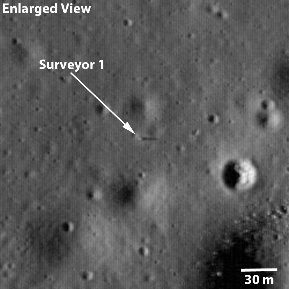
The Russians beat Americans to the Moon in 1966 by only five months. Samuel Lawrence had already written up and released LROC's first views of "Surveyor 1 - America's first soft lunar landing," on September 30, 2009. That observation (M102443995L) swept up the first U.S. lander very early in LRO's Commissioning phase, in orbit 272, when LRO was still flying at twice its Nominal mission altitude, from 102.4 km overhead. That survey of the floor of Flamsteed P was photographed at less than half of the planned LROC NAC resolution; at 1.08 meters per pixel, the Surveyor 1 tripod in profile was barely visible, identifiable mainly in its long shadow at local sunset.The Surveyor design featured a central mast with square solar panels at the top, standing high like a flag. That aided in identifying all five of the successful Surveyor landers, right they sat. 


Unlike its Google Earth icon, seen in Fig. 1, Luna 9 was not standing like an egg, balanced on one hemisphere. After its landing and activation Luna 9 was at tilted, and from slight changes in the background seen in its five photographic panoramas we can tell Luna 9 shifted slightly after deployment.

Fig. 4  Simulated oblique view west by northwest over the area of interest from a point 28 km over the western Oceanus Procellarum. After years of deconstructing the five panoramas captured and returned to Earth by Luna 9, many reliable experts have come to doubt the accuracy of the official landing site (coordinates on the left, at "-1310 m" elevation).  Some believe Luna 9 must have landed somewhere in the plain to the north (on the right, marked "-1640 m").  If the object detailed in Figures 5 and 6 below is Luna 9 then the lander came to rest at a point less than three kilometers and almost due north of the official coordinates ("-1170 m"), and at least 140 meters higher in elevation.  After studying the LROC WAC Digital Terrain Model of the area (Fig. 2) the hills, contiguous with other features surrounding the Plain of Descent, appear to be the highly degraded rim of an ancient, mostly buried crater.  -Image created using ILIADS application, developed by NASA's LMMP project; photography from LROC WAC Global Mosaic with elevations from LOLA altimetry (v.2). [NASA/GSFC/ARC/LMMP/ASU].
The low profile and squat, efficient design of Luna 9 have made it difficult to definitively locate, either somewhere in the expansive plain to the north or near the official position somewhere on a 500 meter high hill, nor on their slopes. All of the area was extensively photographed from LRO, from high altitudes and low, under high Sun and low Sun, with LRO rolled and looking down from directly overhead. If the little vehicle has been captured (which seems certain) what would distinguish its egg shape from thousands of boulders more or less the same size?

It's a safe bet Samuel Lawrence and others on the LROC team encountered this difficulty head-on, with the determination and resourcefulness of a Cold War photo-analyst pouring over U2 photographs of Cuban missile sites. 

In fact, it would be the height of presumption on our part to claim to have done anything more than retraced their steps. It's impossible to believe a candidate object we stumbled on, within their choices of photographic session, hasn't already been considered or scratched off the list. Were it not for something that may turn out to be simply an artifact of digital compression we wouldn't take another look.

Let's just say, "boy, that sure looks like Luna 9!"

What follows are two sets of images, selected from two separate LROC NAC observations, focused on an "object of interest" at sunrise (Figures 5a and 5b), when the Sun was less than 5 degrees over the east horizon, when long shadows allow for depth perception, and then (in Figures 6a - 6d) where, at less than 8° north of the equator, the Sun was high overhead and depth perception gives way to a search for subtle variations in brightness or optical maturity.


Fig. 5a   The full 2.5 kilometer-wide field from LROC NAC M132071202L orbit 4597, June 25, 2010; with resolution greatly reduced from the original 0.48 meter per pixel resolution captured from 40.49 km altitude, incidence angle 85.57°. The yellow rectangle is the area shown at full resolution in Fig. 5b, immediately below. The yellow dot is our "object of interest," so to speak, indicated with an arrow in at full resolution below. The object certainly casts a shadow, as anything with a profile would when caught in naked morning sunshine on the Moon. It is also seemingly brighter than other similarly sized objects in the roughly 238 meter-wide field of view seen below.  [NASA/GSFC/Arizona State University].
Fig. 5b  Full resolution, and very non-definitive rendition of the Object of Interest, again, from LROC NAC M132071202L The object appears to be situated within the west slope of a 10 meter crater, whose interior is very darkened with shadow. Since Luna 9 arrived on the Moon not long after local sunrise, this doesn't help identify the object as Luna 9. The larger, similarly bright object to the southwest is too large to be Luna 9, but its size and location relative to the object of interest makes a case for it being part of the larger lander bus [NASA/GSFC/Arizona State University].
On the 500 meter hills, south of "the plain of descent," under an afternoon Sun:

Fig. 6a  Backing away once again, shifting perspective slightly to the west, with the Sun nearly overhead, this is the field of view within the rectangle back in Fig 3, and slightly west, overlapping the area in Fig. 5a, another 2.5 km-wide area taken this time from LROC NAC M137970706R, orbit 5466, September 1, 2010, from 45.57 km in altitude (incidence angle 29.64°). The area in the white rectangle is the field of view enlarged in Fig. 6b, immediately below [NASA/GSFC/Arizona Sate University].
Fig. 6b  At 40 percent of their original resolution, line 14775 to 15556 by sample 3964 - 4544 from M137970706R. (The dim dark line is an artifact "junction" between line 15000 and 15001). And, like a Russian Doll, the square box above is the roughly 290 meter-wide field of view seen at 100 percent of the original observation's 0.5 meter per pixel resolution seen in Fig. 6c, immediately below [NASA/GSFC/Arizona State University].
Fig. 6c At full resolution, lines 15001 - 15580 by sample 3964 - 4543 from LROC NAC M137970706R. Compare this with Fig. 5b, above and, once again, what is seen under differing lighting conditions on the Moon is clear. When happening upon this candidate object under a high Sun, something catches the eye [NASA/GSFC/Arizona State University].
Fig. 6d  Taking  LROC NAC M137970706R  well beyond its true limit of resolution we stumble upon what might be Luna 9, resting on the west interior slope of a shallow 10 meter crater, perhaps even afterwards sliding slightly between photographic panoramas, February 3, 1966. Under an early afternoon Sun, after being enlarged 400 percent with a super-sampling algorithm, what appear faintly as three of the spacecraft's four instrument-shielding petals (the fourth presumably in its shadow) somehow popped out from the background. No intentional fudging was done to the original brute-force enlargement (See Fig. 7) [NASA/GSFC/Arizona State University].
Fig. 7 A simple enlargement to 400 percent of the half-meter per pixel resolution native to LROC NAC observation M137970706R turned up this object, certainly an oddity if it is not Luna 9. As demonstrated in the hackneyed animated image (Fig. 6d), the object meets the profile, is barely less than 3 kilometers due north of its official landing site, about 140 meters higher in elevation, on a broader slope with presumably less obstructed horizon.

Fig. 8 The view south from Luna 9, February 3, 1966.


Using the popular open-source program Orbital Simulator, "reseferina1" created this interesting simulation of the Luna 9 mission in 1966. Though fun, it too, unfortunately, made the thing look far too easy. The originating YouTube page is HERE.

Wednesday, June 10, 2009

New LOIRP high res Lunar Orbiter image of western Oceanus Procellarum

Planitia Descendus & the western Oceanus Procellarum
LOIRP Restored LO-III image, Feb. 1967

More new high-resolution images have been recovered and released by the Lunar Orbiter Image Restoration Project (LOIRP), restored from repeated sweeps of data transmitted to Earth originally from Lunar Orbiter III in Feb. 1967.

Even at a comparatively high altitude this capture of Planitia Descendus (the low hills and ancient craters on the peninsula at the near center along the western Oceanus Procellarum) rivals many returned from Japan's Kaguya.

Somewhere in this image is the landing site of Luna 9, the first successfully soft-landed vehicle on the Moon, sent by the Soviet Union and arriving the same month a year earlier, on February 3, 1966.

Luna 9's landing site is somewhat disputed because images returned from the lander show a flat region with what may be hills some distance away though official coordinates (296.0° E, 7.0°N) put the egg-shaped 82 kg lander right in the middle of the rough terrain of those same mountains of Descendus (or "the plain of descent," in honor of the Soviet achievement).

Looks can be deceiving though, but there's obviously not much flatland at that location. So where is Luna 9? There have been many excellent, educated speculations over the years. Forty-three years later, perhaps the Lunar Reconnaissance Orbiter (LRO) can finally solve this mystery.

Just this side of the largest distinct crater on the flat plain of the Sea of Storms, at the top of this image (west of Reiner Gamma, out of view) is the resting place of Luna 8, which may have landed successfully Dec. 7, 1965, though all contact with the earlier Soviet probe was lost at or near landing.

The United States successfully landed Surveyor 1 on June 2, 1966, 700 kilometers to the southeast, inside the half buried rim of Flamsteed but still well inside the vast plain of Procellarum beyond that small part seen here.

At least one LOIRP restored Lunar Orbiter image has resolved and confirmed Surveyor 1's location.

See full images and read Moonviews' story HERE.