Sunday, November 30, 2014

Is there an economic case for mining the Moon?

Of necessity, much of the actual work of harvesting resources for true in situ resource utilization (ISRU) will have to be done robotically [Pat Rawlings/SAIC].
Ian Crawford
Birkbeck, University of London

To date, all human economic activity has depended on the material and energy resources of a single planet; understandably, perhaps. It is conceivable though that future advances in space exploration could change this by opening our closed planetary economy to essentially unlimited external resources of energy and raw materials.

Look up at the Moon this evening, and you might be gazing at a solution. The Earth’s closest celestial neighbour seems likely to play a major role and already a number of private companies have been created to explore the possibilities.

It is important to stress that even now, 40 years after the Apollo missions, we still don’t have a complete picture of the Moon’s economic potential, and obtaining one will require a more rigorous programme of lunar exploration than has been undertaken to-date. In part, this is why proposed future lunar exploration missions (such as the recently announced Lunar Mission One) are so important.

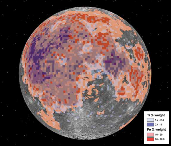
"In addition, lunar surface rocks and soils are rich in potentially useful, but heavy (and thus expensive to launch from Earth) raw materials such as magnesium, aluminium, silicon, iron and titanium." - Relative abundances of titanium and iron, as a percentage of weight, plotted against the nearside hemisphere. Note the heaviest incidences appear in the Ocean of Storms and Sea of Tranquility.
Nevertheless, as a result of work over the past four decades, we do now know enough to make a first-order assessment of lunar resource potential. In doing so it is useful to distinguish between three possible future applications of such resources.

Read the full article published at The Conversation, HERE.

NOTE from Mr. Crawford: "This essay is based on a much more detailed review article which will be published next year, and in which references to sources and more extensive discussion will be found here: arXiv.org/abs/1410.6865."

Sunday, November 23, 2014

Dark splotches over high albedo, under a high sun

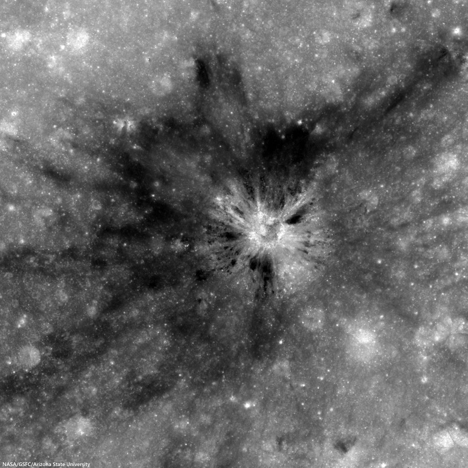
Unnamed crater (2.2784°N, 116.2125°E) southwest of King, presenting a unique albedo variation in 1.8 km-wide field of view from LROC NAC observation M123812230R, LRO orbit 3380, March 21, 2010; 8.3° incidence angle, resolution 57 cm from 55.36 km over 2.25°N, 116.16°E [NASA/GSFC/Arizona State University].
Hiroyuki Sato
LROC News System

Impact craters routinely excavate subsurface materials, exposing them in crater walls and in ejecta. The Featured Image highlights an unnamed fresh crater (480 meters in diameter) with numerous dark splotches.

Inside the crater cavity, dark splotches (low reflectance materials) occur from the middle to the trim of the crater and spread outward beyond the rim crest.

Several small craters (less than 100 meters in diameter) with similar dark splotches also occur in this region (outside the area shown above, see next image), suggesting that the dark materials were likely excavated from an extensive subsurface layer. The distribution of the dark halo craters informs us about the horizontal extent of these subsurface materials.

Small craters a few thousand meters north of the dark halo crater (DHC) of interest, above, from the same LROC NAC frame M123812230R. Note the crater right of center bottom may be superposed on the rim of a more ancient depression [NASA/GSFC/Arizona State University].
The crater in the opening image is found 116 km from the southwestern rim of King crater (76.2 km; 4.96°N, 120.49°E), located in the farside highlands. Unlike in the mare, pyroclastic deposits are unlikely to be the low-reflectance material (seen in the opening image) here in the middle of the highlands with no indication of volcanic activity near here. So, what is this low reflectance layer?

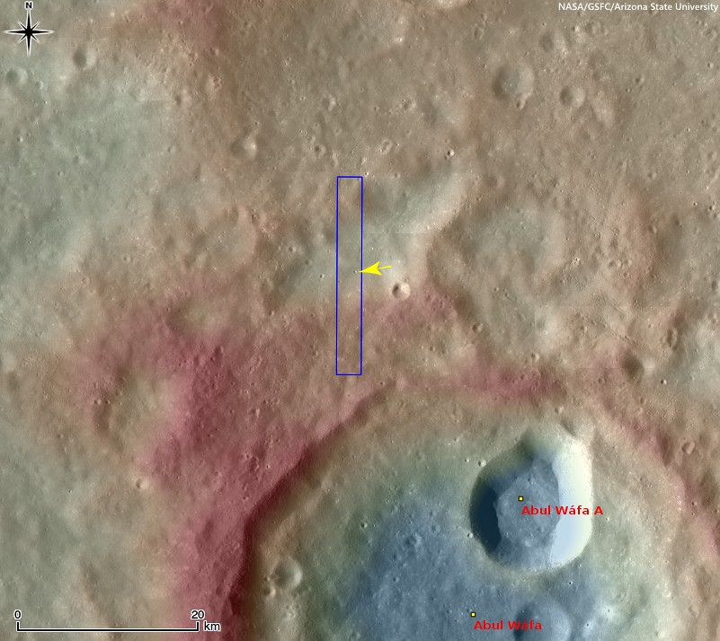
Context view of the location of today's Featured Image in WAC monochrome mosaic (100 m/pix) overlayed by WAC stereo DTM (GLD100, Scholten et al., 2012). The NAC footprint (blue box) and the exact location of the opening image (yellow arrow) are indicated [NASA/GSFC/Arizona State University]. 
The rays of Necho crater (36.87 km; 5.25°S, 123.24°E) extend out around 680 kilometers (see image below) crossing over King crater and the area in today's Featured Image. Since the area of opening image is crossed by the Necho ray deposits the excavated dark layer might be the original mature surface (now covered by Necho's high reflectance rays).  

Context view of the area of interest in an orthographic LROC WAC mosaic of low-angle observations of the surrounding hemisphere. Arrow points to the location of the crater of interest, within range of ejecta from King, Necho or perhaps, less likely, Giordano Bruno or Goddard A craters, (not unlike the magnetic anomaly east of Firsov) [NASA/GSFC/Arizona State University]. 
Due to the lack of atmosphere on the Moon, the photometric effect is very strong. Thus, it is hard to identify the relationships between the different layers using low-Sun images (images with large incidence angles, near sunrise or sunset); however, high-Sun images (those with low incidence angles, near noon) display clearly the relationships between units, which helps us reconstruct the resurfacing history of this area.

View full-size view of the LROC NAC frame, HERE.

Related Posts:

Tuesday, November 18, 2014

Mottled mound at Firsov

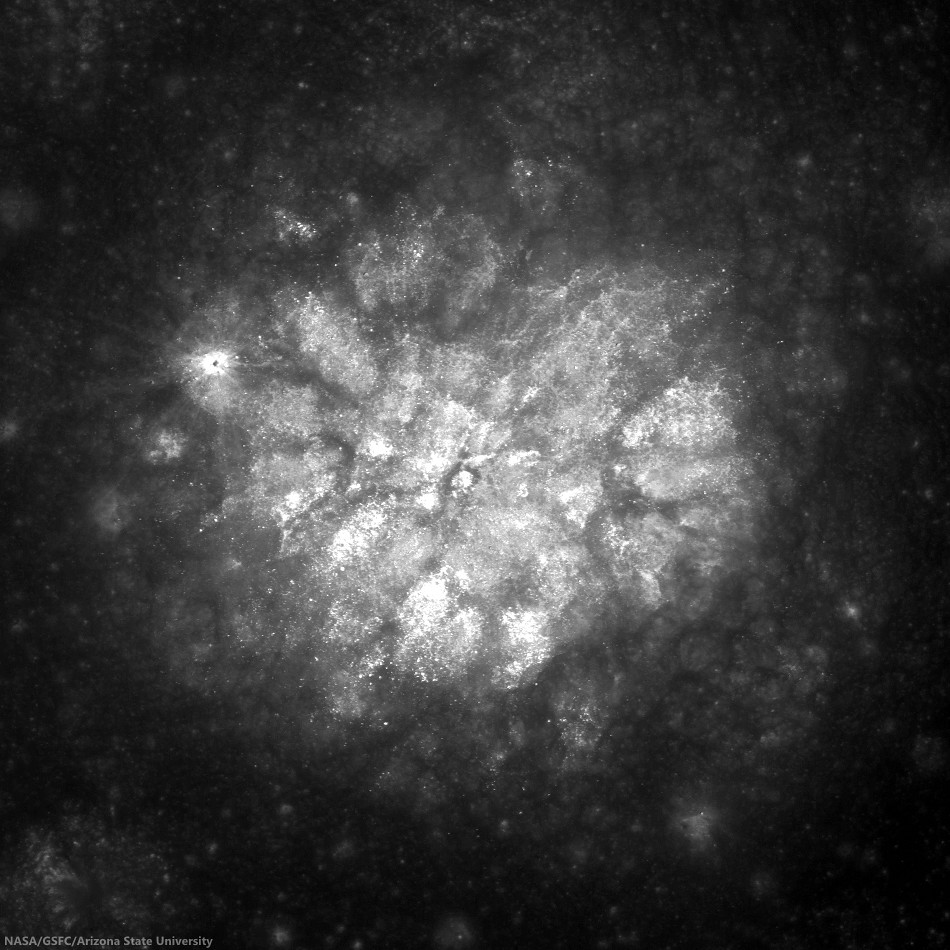
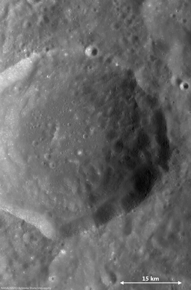
Low-angle incidence view of a curious mound on the floor of Firsov crater (51 km; 4.204°N, 112.697°E). 2.2 km field of view from LROC NAC observation M187506567R [NASA/GSFC/Arizona State University].
Hiroyuki Sato
LROC News System

Firsov is a 51-km diameter crater located in the farside highlands, approximately 240 km east of King crater. The depth of Firsov's floor from the rim crest is an impressive 4.5 km (that’s 2.5 times the depth of the Grand Canyon in Arizona).

The bright (highly reflective) mound on the crater floor is about 200 meters in height, and 2.5 km in diameter, and really catches your eye. The central portion of the crater floor is relatively flat, suggesting that it at least partially consists of a long-solidified pool of impact-melt; the mound is located within this melt pond deposit.

46 km-wide field of view showing  the high-reflectance mound feature, near center of FriFirsovater, from LROC WAC monochrome (643 nm) observation M176892340CE, LRO orbit 11204, November 25, 2011; 62.51 incidence, resolution 58.62 meters from 43.41 km [NASA/GSFC/Arizona State University].
A number of previous Featured Image posts explored the origins of mounds occurring inside impact craters. Hypotheses include volcanic eruptions, impact debris, and the squeeze-ups of impact melt.

Today's Featured Image highlights the degradation of these mounds, instead of their origin. The low-incidence angle of the top image (~9°) highlights differences in albedo on the mound top, what causes these bright patches?

Perhaps, as the mound surface degrades over time, the high-reflectance materials are exposed unevenly, for example, due to a bumpy surface morphology, where local, topographically high portions are exposed faster and newly exposed material is immature (and thus brighter).

Alternatively, the mound may be constructed from non-uniform materials and/or compositions that exhibit a range of reflectivities. However, scientists believe that during impacts any compositional differences within the target are homogenized in melt deposits. This mound would be a great place to examine that hypothesis.

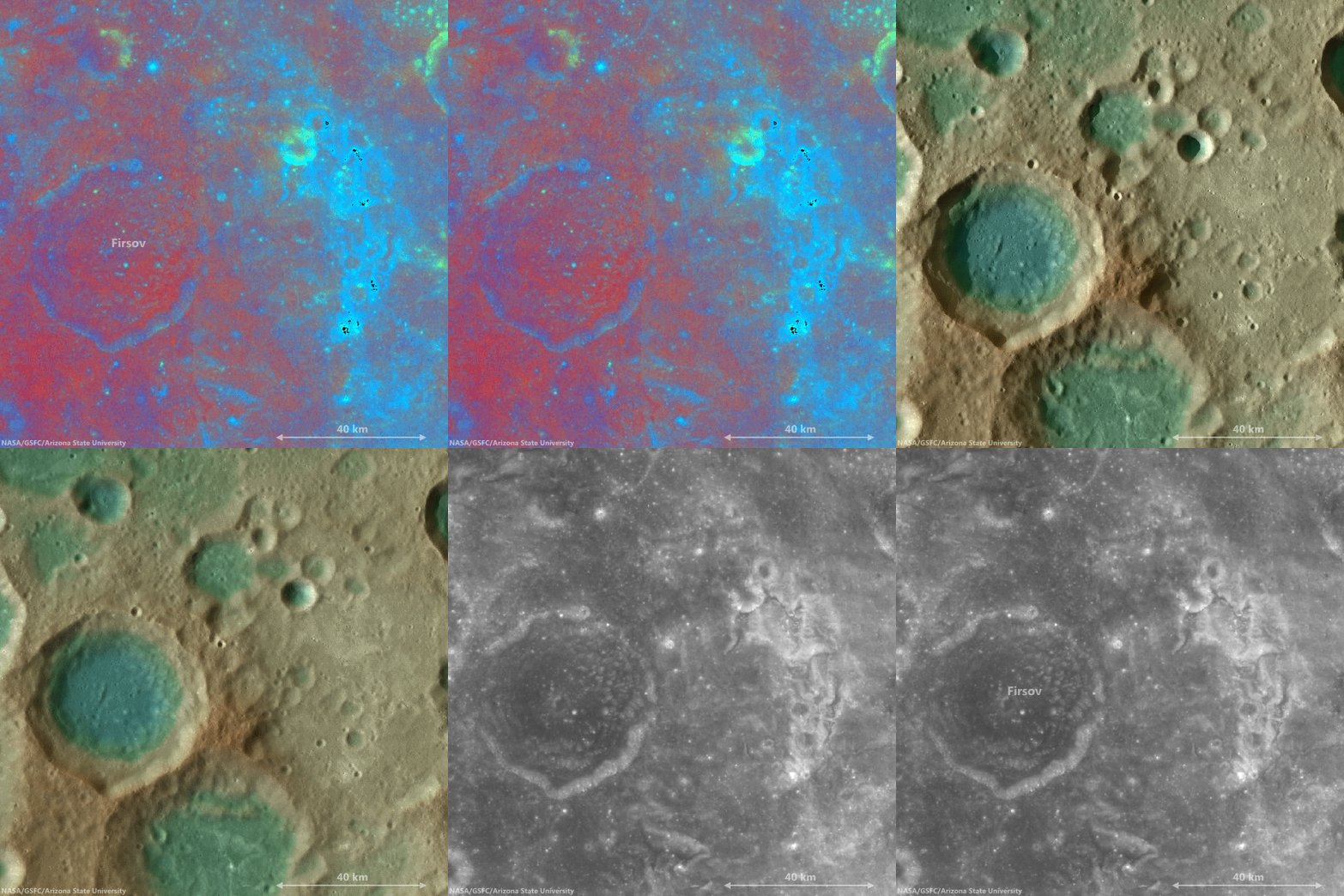
The bright mound southeast of center on the floor of Firsov is not the only albedo "anomaly" in the vicinity of Firsov crater. This cycle of overlapping fields of view, juxtapositioning data ranging from LROC WAC-derived elevation models to Clementine UV-VIS color ratio maps from 1994, brings into stark relief the unnamed Copernican era crater northeast of Firsov, and also the dramatic patch of albedo swirls coincident with a locally intense crustal magnetism, photographed from orbit by the crew of Apollo 10. It seems distant and detached, but still these swirls are likely associated with the widely-scattered swirl fields farther to the west at Mare Marginis, on the opposite side of the Moon from the energetic basin-forming impact that formed Mare Orientale 3.1 billion years ago [NASA/GSFC/Arizona State University].
View full-window, HERE.

Related Posts:
Shiny Mound
Kagami-mochi on the Moon!
Pancakes in a melt pond
Donut Holes
The Domes of Stevinus Crater
That's a Relief

Friday, November 7, 2014

Exploring the lunar subsurface

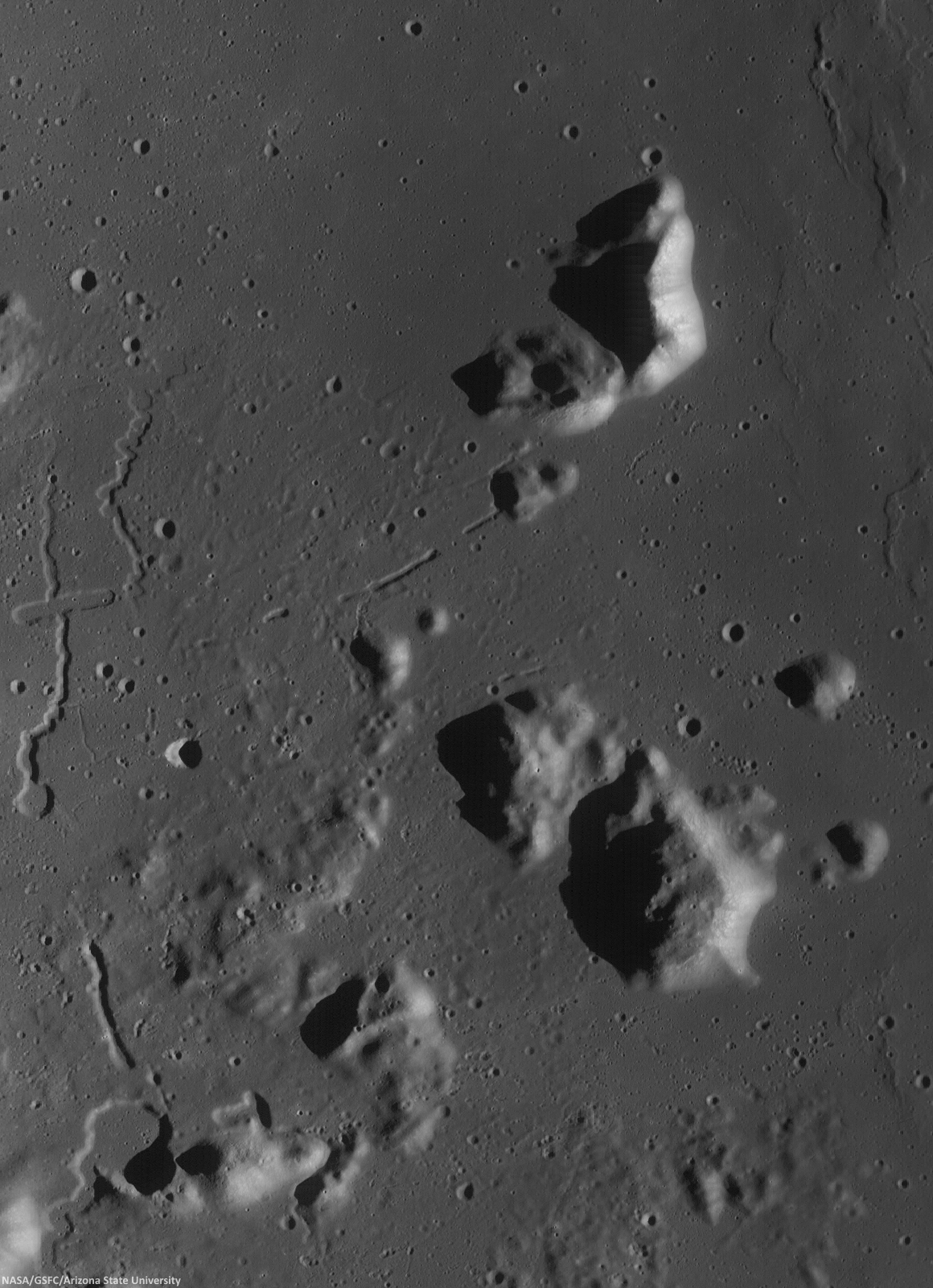
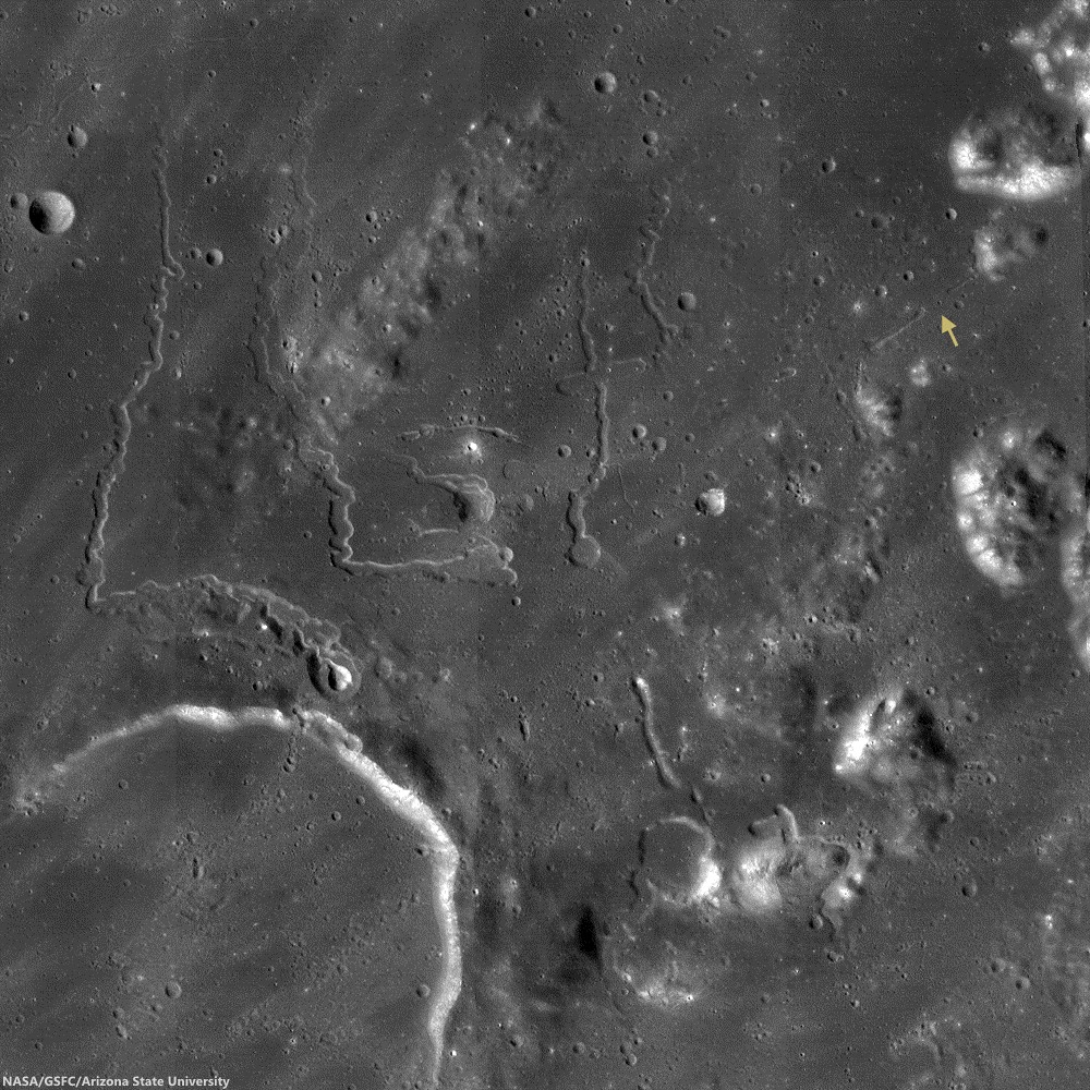
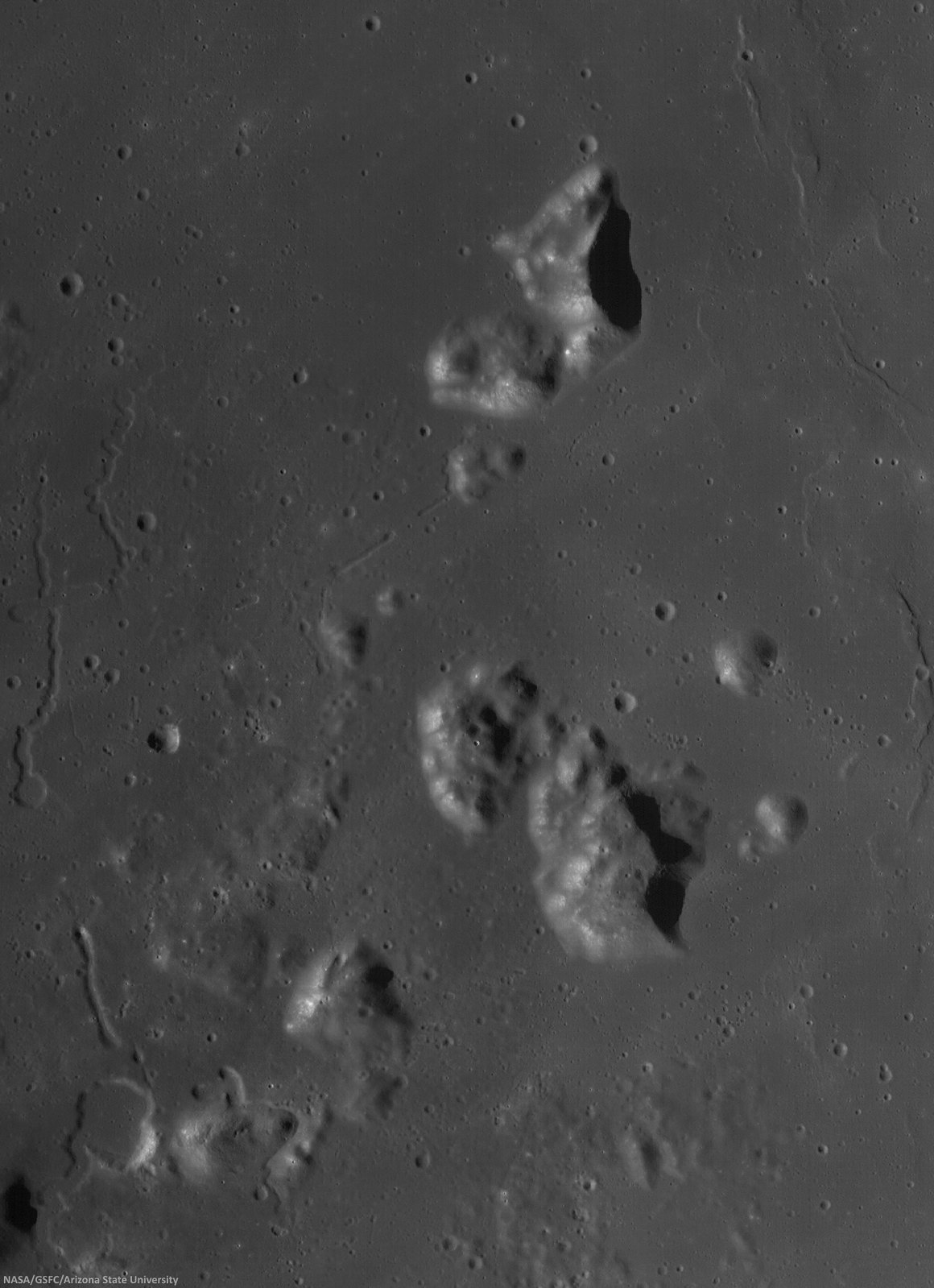
Two collapsed segments of a lava tube run from the southwest to the northeast, in the Rimae Prinz-Harbinger mountain region of Oceanus Procellarum (27.46°N, 318.33°E). These collapsed segments may provide access to the subsurface, which has never been directly sampled. The average width of the collapsed segments is ~650 meters. The lava tube is ~50 meters deep, seen in this 7 km-wide field of view from a mosaic of unreleased 2014 LROC NAC observation M1165080128 (L&R) [NASA/GSFC/Arizona State University].
H. Meyer
LROC News System

A lava tube is a volcanic conduit through which lava travels beneath the hardened crust of a lava flow. The presence of lava tubes on the Moon and beyond are inferred based on observations of terrestrial lava tubes, such as those found in Hawaii. Oftentimes, a rille suddenly disappears only to reappear a short distance away.

These are called discontinuous rilles and are thought to be areas where a lava tube collapsed. Collapsed lava tube segments may provide access to the subsurface, which is exciting as a possible site to collect rock samples that remain unaltered due to surface weathering (radiation, thermal cycling, micrometeorite bombardment).

Slightly differing, slightly lower resolution, 11.5 x 15.9 km field of view of the area of interest from a mosaic of LROC Narrow Angle Camera (NAC) observation M1152143995RL, LRO orbit 21776, April 14, 2014; resolution averages 1.33 meters per pixel, incidence angle 48.9° from 132.14 km over 26.86°N, 318.11°E. View the original 8706 x 12008 and an assortment of other sizes HERE [NASA/GSFC/Arizona State University].
Sunrise over Mons Harbinger. 65 km-wide field of view from mosaic of three LROC Wide Angle Camera (WAC) monochrome (604 nm) observations, swept up during three sequential orbital passes, December 7, 2011,  from 43 km; resolution 58 meters per pixel, incidence 77° [NASA/GSFC/Arizona State University].
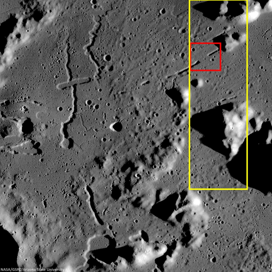
Context for LROC Featured Image released November 6, 2014, field of view in red, full field swept up in LROC NAC observations M1152143995R & L in yellow. LROC WAC mosaic [NASA/GSFC/Arizona State University].
The lava tube from the LROC Featured Image released November 5, 2014 is located to the west of Montes Harbinger, a large kipuka in Oceanus Procellarum, and to the east of the Rimae Prinz region.

The Rimae Prinz region displays exquisite sinuous rilles as well as other elongate depressions, indicating that there could be other lava tubes in the area.

The Prinz, Rimae Prinz and Vera vent region, east of Aristarchus Plateau. The area of interest is marked with a yellow arrow, upper right in this roughly 120 km square field of view from the LROC WAC 100m global mosaic. the Vera vent 'cobra head' of Rima Prinz I rille (on the north-northeast rim of basalt-inundated Prinz crater, at lower left), is the subject of intense study (see HERE). [NASA/GSFC/Arizona State University].
The entire region, pictured above, is of interest for exploration for several reasons. The diversity of volcanic landforms in the area can tell scientists much about the volcanic history of the Moon. By collecting samples from the surface and subsurface in this region and by careful mapping on-site, scientists can better characterize the diverse basaltic lava flows in terms of both age and composition, which also helps us understand the timing and evolution of lunar volcanism and possible heterogeneities in the lunar mantle. Any time a sample is taken from a site on the Moon and age-dated, it can also be used to calibrate crater densities that are currently used to remotely age-date surfaces in the absence of direct sampling (both on the Moon and other planets).

Lava tubes are of particular interest in terms of human exploration because they are not only scientifically valuable, but they might also provide shielding from the radiation that poses a hazard to future explorers. Furthermore, the region surrounding the lava tube from this Featured Image also hosts large pyroclastic deposits, which are a potential in situ resource that will be critical to sustaining a human presence on the Moon.

Scientists and engineers are looking into the possibility of using the natural structure of the lava tube and associated resources (ISRU) to our advantage to construct habitats for explorers.

Explore the full NAC mosaic here! How many features of interest do you see?

Rimae Prinze Region - Constellation ROI
Discontiguous Rilles

Addendum: Under mid to late afternoon sunlight, another LROC WAC mosaic, swept up under conditions remarkably similar in scale with the third image from above, from the same period of low altitude opportunities the LRO mission afforded during orbital maneuvers in the second half of 2011. Differing sun-moon-spacecraft phase angles allows for an excellent comparison. This particular mosaic was also assembled from LROC WAC observations, but five months earlier, and from three sequential orbital passes, at 43 km altitude. The resolution is 59 meters, incidence angle 64° [NASA/GSFC/Arizona State University].

Sunday, November 2, 2014

China celebrates successful “Xiaofei”

Xiaofei, China's 'little flyer,' flight dynamics test platform for the scheduled Chang'e-5 sample return mission in 2017, appears charred but otherwise none the worse for ware following a high-speed direct re-entry from the Moon, encountering Earth's outer atmosphere at an estimated 11.2 km per second, early November 1, 2014 [Xinhua].
Tom Phillips
London Daily Telegraph

China has taken one more step in its ambitious plans to become a global space power by completing the successful re-entry and landing of an unmanned space probe.

The “Xiaofei” or "Little Flyer" lunar orbiter began re-entry into the earth’s atmosphere at 6.13am on Saturday and subsequently landed in Inner Mongolia, state media reported.

The probe was launched eight days ago and travelled more than 520,000 miles during its mission around the Moon.

The mission to the Moon was “another step forward for China's ambition that could eventually land a Chinese citizen there,” Xinhua, China’s official news agency, said. It was “the world's first mission to the Moon and back for some 40 years”.

Saturday’s landing is the latest advance for a space program that China’s leaders see as an important way of commanding international respect. Some Chinese scientists have said they hope space exploration might help them discover precious natural resources that could help satisfy the country’s ravenous hunger for raw materials.

Read the full article from the Telegraph, HERE.

Saturday, November 1, 2014

Lunar exploration will reduce shortage of rare earths

The store of our knowledge of the Moon grew exponentially in the wake of America's brief but still lingering commitment to the Vision for Space Exploration (2004-2009), without which the LCROSS, LRO, LADEE and GRAIL missions would not have been funded.
A planned Russian return to the lunar
surface may benefit from a post-
Fobos-Grunt shakeout.
Aram Ter-Ghazaryan
Special to Russia Beyond the Headlines

As part of the Federal Space Program, Moon exploration operations will be launched in 2016. In 2018 the first spacecraft will be sent to the Moon to deliver comet material back to Earth. 

A manned flight is scheduled for 2030-2031. Future plans include the mining of rare earth metals required for the development of high-tech industries.

Scientists from the Russian Academy of Sciences, the Moscow State University Sternberg Astronomical Institute and the Russian Federal Space Agency are participating in this Moon exploration project.

The first spacecraft to be sent to the Moon will be relatively simple. According to Vladislav Shevchenko, the Sternberg Institute’s Head of the Department of Lunar and Planetary Research, this is because the Russian space program has not carried out a Moon landing for over 40 years.

“The last Luna-24 launch was carried out in 1976. The current spacecraft, Luna-25, is a lot lighter than its predecessor, as its main mission is to bring back ice from the lunar south pole,” Shevchenko said. According to him, the south pole was chosen because according to satellite data, it houses the largest reserves of frozen volatile gases found in comets.

Read the full article at Russia Beyond the Headlines, HERE.

The last direct sample of the Moon returned to Earth was retrieved by the Soviet Union's Luna 24 robotic lander on August 18, 1976 (in total darkness). The vehicle landed on the rim of this 64 meter-wide crater on the southeastern plains of Mare Crisium (12.717°N, 62.222°E) and the Lunar Reconnaissance Orbiter (LRO) LROC Narrow Angle Cameras (NAC) imaged the lander's descent stage (lower left) on November 2, 2011, from only 25.57 km overhead. LROC NAC M174868307L, LRO orbit 10904, resolution 43 cm per pixel [NASA/GSFC/Arizona State University].