Showing posts with label Impact Melt Pit. Show all posts

Tuesday, March 5, 2013

Copernicus collapse pit

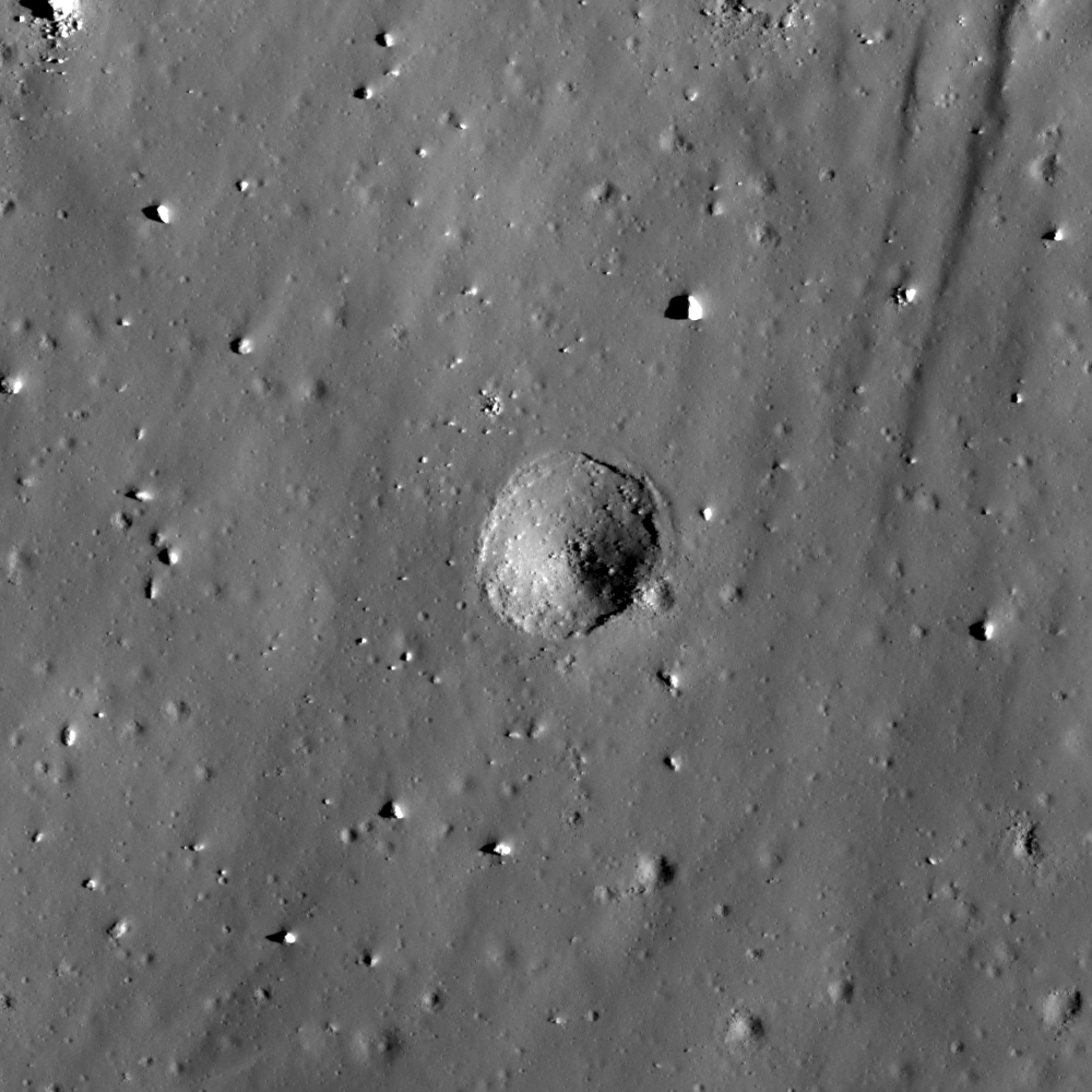
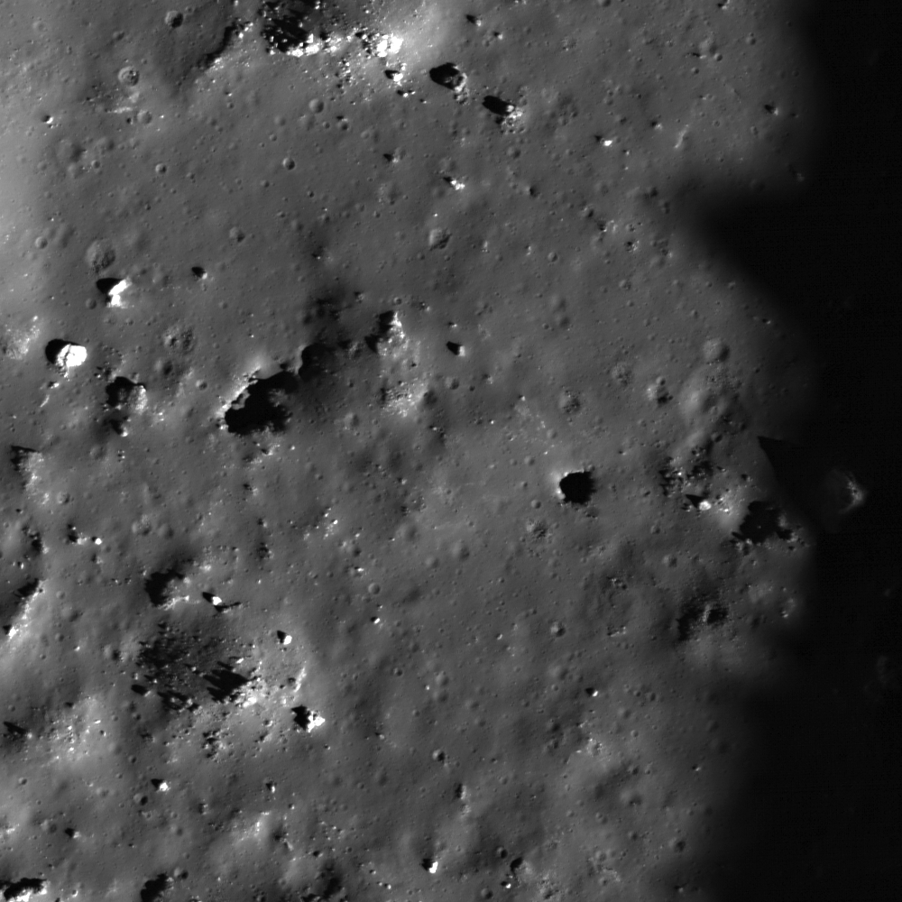
Collapse feature in the impact melt on the floor of Copernicus, field of view 430 meters, from LROC Narrow Angle Camera (NAC) observation M168333206L, LRO orbit 9941, August 18, 2011; resolution 40 cm per pixel from 25.4 kilometers. Originally posted to illustrate "Failed Skylights of Copernicus," January 24, 2012 [NASA/GSFC/Arizona State University].
Sarah Braden
LROC News System

A fresh collapse feature within the impact melt floor of Copernicus crater is 330 meters across (that's about 3 American football fields wide!). At one point the impact melt in this area was flat, but then the area collapsed forming the feature here (located at 10.204°N, 339.998°E). The rim of the depression is still very fresh with outcrops and boulders.

An estimate of the feature's depth is approximately 50 meters, based on shadows from another NAC image of the same area. There are a few possible causes for the collapse.

A subsurface void may have formed as the impact melt flowed and cooled. Subsurface voids occur when melt emplaced shortly after the impact drains away deeper into the impact cavity. Perhaps a small bolide impacted the surface and instigated the collapse of the structurally weak void. Alternatively, the collapse might be due to seismic shaking from moonquakes disturbing the weak section of the melt deposit.

Oblique view of the featured collapse pit, from well to the east of Copernicus; a montage of the left and right frames of LROC NAC observation M193025138 (thumbnail at bottom), orbit 13472, May 30, 2012. Spacecraft slewed from 63.11° from nadir [NASA/GSFC/Arizona State University].
This collapse feature is much larger in diameter than the mare pits: the Mare Ingenii pit is about 130 meters in diameter, the Marius Hills pit is about 65 meters and the Mare Tranquillitatis pit is around 100 meter across.

Pits in mare basalt may have formed when a portion of a lava tube collapsed. The subsequent pit is a skylight that leads into the intact lava tube. Impact melt pits are common within impact melt deposits like the one here in Copernicus, however the depression in the Feature Image is larger in diameter than average impact melt pit. Perhaps in this case the subsurface void was larger, or the surface layer of impact melt was structurally weaker, resulting in a larger collapse area.

Arrow marks location of the featured collapse pit, near an north-south contact between distinct impact melt types, easier to visualize, perhaps, in color and other images highlighting lunar surface albedo. LROC Wide Angle Camera (WAC) monochrome mosaic M147109260C, orbit 6813, December 16, 2010; resolution 60 meters from 43 km, angle of incidence 78°
A previous Featured Image, "Copernicus Seen Looking Straight Down," featured a mosaic of Copernicus's floor (9.62°N, 339.92°E, 93 km in diameter), but today's Featured Image offers much higher resolution.

Explore the entire NAC frame for more high resolution impact melt deposits, HERE

Related Images:
Copernicus Seen Looking Straight Down
Copernicus Central Peak
Natural Bridge on the Moon!
Impact Melt Pit
Failed Skylights of Copernicus

Thursday, October 11, 2012

Hole on A Melt Sheet

A portion of the impact melt sheet on the floor of crater Korolev X. Image centered on 0.699°N, 200.594°E, field of view is 638 meters, illumination from the right, or east. From LROC Narrow Angle Camera (NAC) observation M145664820R, LRO orbit 6600, November 29, 2010; angle of incidence 61.4° at 0.64 meters resolution, from 61.62 kilometers  [NASA/GSFC/Arizona State University].
Hiroyuki Sato
LROC News System

Korolev X is a 25-km crater located at 0.54°N, 200.59°E. As seen in the bottom image, the northern rim of this crater was destroyed by a younger crater about 16 km in diameter. The heat from the impact that formed this younger crater melted a large volume of rock, which flowed down onto the floor of Korolev X, creating a sheet of solidified melt 14 x 5 km across. The opening image highlights a dent in the surface of this melt sheet.

This dent is about 105 meters in diameter. Considering the existence of multiple, similarly-sized (around 100 m in diameter) craters on this melt sheet, this dent is most likely an impact crater even though neither an ejecta blanket nor a raised rim can be clearly recognized. Along the top of the crater wall there appears to be a thin layer of the melt sheet that is exposed and highlighted by the angle of the sun. Below this surface layer no clear layering is observed, implying a rather homogeneous structure. Small craters like this are often observed in impact melt sheets, and why they lack typical features of impact craters (a well-defined raised rim, a thick ejecta blanket) is still not well known. Could these craters have formed when the impact melt was still partially molten?

Korolev X and surroundings from an LROC WAC monochrome mosaic (100 m/pixel) centered near 0.52°N, 200.57°E. The blue box indicates the footprint of LROC NAC observation M145664820R with their Featured Image field of view designated by the yellow arrow [NASA/GSFC/Arizona State University].

Explore various strangely shaped craters on this melt sheet in full NAC frame yourself, HERE.

Related Posts:
Necho Crater
Scalelike Impact Melts
Impacts on the Melts
Impact Melt Deposits On A Crater Rim

More detail, at small scale, shows the elevation range north and south of Korolev X, near the rim of mighty Korolev basin. Less than 200 km to the north of the area of interest is the Moon's highest elevation. Though all of Korolev range as high as 10.2 km lower than the east rim of Engel'gardt (and unlike the familiar nearside basins), nowhere in Korolev falls below the Moon's global mean. The farside of the Moon is very different than the nearside [NASA/GSFC/Arizona State University/DLR].

Thursday, August 16, 2012

LROC: Melt pit on the floor of Louville D

Fractured impact melt with a probable impact melt pit inside the crater Louville D. LROC Narrow Angle Camera (NAC) observation M170897609R, LRO orbit 10319, September 17, 2011; resolution 0.5 meters from 45.36 km [NASA/GSFC/Arizona State University].
Sarah Braden
LROC News System

Louville D is a young crater, 6.89 km in diameter, located in northeastern Mare Procellarum (46.85°N, 52.13°W), near Sinus Roris.

The Featured Image shows a group of fractures and one possible pit (center of image) within the impact melt at the bottom of Louville D.

How do we determine what is a possible impact melt pit and what is a shadow from a boulder? The most important source of information on this is multiple images at different viewing angles.

For instance, in one image the Sun is low in the sky and many shadows are cast due to crater rims, boulders, and fractures. In a different image with the Sun high in the sky there are almost no shadows. In this high-sun case, pits are extremely visible as dark areas that reflect very little light back into space. High-sun images result in an unambiguous identification of a lunar pit. But what happens when we do not have a high-sun image of a potential pit?

A smaller-scale image from LROC NAC M170897609R show the floor of Louville D in context with the contact zone with the 6.89 km-wide crater's walls [NASA/GSFC/Arizona State University].
While looking at an image with many shadows, it may be unclear if an area is a shadow or an actual pit in the impact melt. Most of the time you can see the boulders well enough to match a shadow to the corresponding boulder, but sometimes the boulders or the topography can be hard to see. A handy trick is to look at the amount of light in the dark area. In most cases, there is enough light in shadows for LROC to detect. This light is reflected into the shadows by surrounding objects. However, less light can reach the inside of a pit, and LROC will detect overall less light in pits.

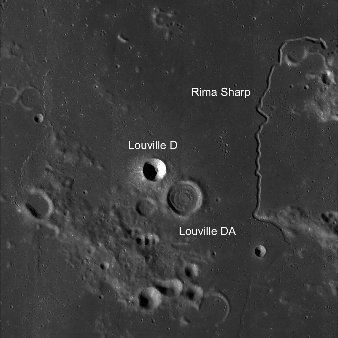
LROC WAC context image of Louville D with Rima Sharp to the east. The full-size Wide Angle Camera mosaic field of view 100 km [NASA/GSFC/Arizona State University].

Explore a closer look at this possible impact melt pit and the floor of Louville D in another full resolution NAC frame (M142604009R), HERE.

Related Posts:
Impact Melt Pit
Natural Bridge on the Moon!
Sublunarean void 
A view of Rima Sharp and Louville D and Louville DA from the north from a Planetary Camera image captured by Japan's lunar orbiter SELENE-1 (Kaguya) [JAXA/SELENE]
There's a lot more natural history engraved on this area of the lunar surface than meets the casual observation, shown by the USGS, reduced from USGS Rumker I805 [USGS].

Friday, March 2, 2012

LROC: Impact melt collapse pit

Pit in an impact melt pool on the floor of an unnamed highland crater northwest of Wood S. LROC Narrow Angle Camera (NAC) observation M176082220L, orbit 11084, November 16, 2011; field of view roughly 278 meters across. View the larger LROC Featured Image HERE [NASA/GSFC/Arizona State University].
Sarah Braden
LROC News System

Impact melt pits are a type of lunar feature now seen in many LROC NAC images. Today's Featured Image shows a newly discovered pit within the impact melt of a relatively small, unnamed crater with a diameter of ~10.8 km (located at 43.899°N, 235.679°E). The impact melt deposit in the crater floor is only ~2.5 km across. The pit is roughly circular with a diameter of ~16 meters. This diameter is smaller than the large pits found in mare basalt: the Mare Ingenii pit is ~130 m in diameter, the Marius Hills pit is ~65 m in diameter, and the Mare Tranquillitatis pit is ~100 m in diameter.

The formation mechanism for pits in mare basalt and in impact melt is likely similar. Pits in mare basalt are may have formed when a portion of a lava tube collapsed. The subsequent pit is a skylight that leads into the intact lava tube. In the case of impact melt pits it is thought that if the impact melt deposit is thick enough the surface of the melt will cool but the interior will stay molten for a period of time. As the floor of the crater below the impact melt changes after the initial impact, the still-molten melt would be forced to flow under the new crust, possibly draining through a new crack or opening under the impact melt surface. This movement would leave a void underneath the surface of the impact melt. At some point later, a portion of the surface collapsed, leaving the pit we see here.

Two different NAC images of the pit with different incidence angles. Red arrows point to the same features in both images. The blue arrows point to the pit itself [NASA/GSFC/Arizona State University].
Higher sun angle (lower incidence angle) images allow scientists to calculate the depth of this impact melt pit. In the image above, two observations give a slightly different view of the main pit (blue arrow) and the irregular fracture (which could be a second pit) to the west (red arrow on the left), but the floor of the pit is not visible at either incidence angle.

LROC WAC image of a young ~10.8 km diameter crater with impact melt and a collapse pit [NASA/GSFC/Arizona State University].

Explore the entire NAC frame to see more of this exciting melt deposit!

Related Posts:
Failed skylights of Copernicus
Layering in Messier A
Natural Bridge on the Moon
How Common are Mare Pit Craters?
Depths of Mare Ingenii
Sublunarean Void!
New Views of Lunar Pits

Tuesday, January 24, 2012

Failed skylights of Copernicus

More than mere melt fracture, a narrow skylight among myriad melt fractures in the chaotic interior of the familiar nearside landmark Copernicus, at a resolution of 40 centimeters per pixel from 25.4 kilometers, August 18, 2011. LROC Narrow Angle Camera observation M168333206L; illumination from the southwest (bottom left) of directly overhead, angle of incidence 38.23° [NASA/GSFC/Arizona State University].
Joel Raupe
Lunar Pioneer

The LROC targeting team had already extensively mapped the interior of Copernicus before the brief period last August when the low point in the LRO polar orbit was reduced by half, sometimes below 25 kilometers. Copernicus might be the most photographed lunar crater after Tycho. Both of these relatively young impact craters are difficult to miss in any view of a waxing Moon seen from Earth. Both craters center on extensive and bright ray systems, and Tycho's being the youngest of the two can be picked out with the naked eye.

Copernicus, though larger than Tycho, seems less intense, almost smudged, and, indeed, it is more faded a more along in years, nearly old enough for the inevitable effects of space weathering to have gardened its face with optical maturity.

The interior, slumped terraced walls, rim and some of the ejecta blanket of Copernicus as seen in one of the very first LROC Wide Angle Camera (WAC) mosaics released by Arizona State University in early 2010. At its roughly 800 million year age Copernicus, namesake of the "revolutionary" polish astronomer Nicolas Copernic (1473-1543), has lent its name to the Copernican Age on the lunar timescale, that relatively recent and relatively sparse period of bombardment. Its interior is flatter in the north than at the south and features three central peaks. A bifurcated pattern to its rays system and topography has led some to speculate at least two progenitors of nearly equal size were involved in this impact event [NASA/GSFC/Arizona State University].
As LROC team member James Ashley was spotlighting the melt fractures of Jackson crater earlier this month we were already performing a survey of the same features on the floor of Copernicus, particularly within the crater's north-central and "more featureless" interior. The melt fractures within Copernicus seem more extensively gardened, and may have formed in a somewhat different way than those at Jackson. At Copernicus there seems to have been, or still may be, voids under the impact melt, and some evidence of what may be bubbling, places that seem to be half-submerged solid rubble on the floor of Tycho, for example, may be place where gases were trapped for a time, escaping after the impact melt had rapidly cooled and solidified.

The north central floor of Copernicus only seems less distinctive than the jumbled topography of its surroundings. Barely visible in this LROC WAC monochrome (643 nm) image is a web of fractures and channels throughout the most level terrain above. A 35 km-wide field of view from LROC WAC observation M147109260C, orbit 6813, December 16, 2010; resolution 60.3 meters per pixel at an incidence angle of 78° from 43.13 kilometers [NASA/GSFC/Arizona State University].
Both the north and south ends of this 42 meter-wide exposed fracture on the floor of Copernicus are nearly buried or are not quite as wide as this section. While its tempting to see the western side as an overhang, and despite the apparent differences in the opposing edges, the exposed rift is likely only slightly deeper and more shadowed. There is evidence enough for voids under the floor of Copernicus but the more obvious clues have been pulverized by space weathering and moon quakes since the crater's formation. LROC NAC observation M157730473L, orbit 8379, April 18, 2011; angle of incidence 24.32° on a field of view 270 meters wide at a resolution of 0.47 meters from 37.85 kilometers [NASA/GSFC/Arizona State University].
Is this 300 meter-wide feature on the floor of Copernicus a crater, a void shaken to collapse or a little of both? Apparent layering in rapidly cooling impact melt may be a result of differing arrival times of the melt. LROC NAC M168333260L [NASA/GSFC/Arizona State University]. 
The area of interest on the floor of Copernicus is distinguished by its melt fractures, many obvious and others mysterious. The traces of these fractures are often marked with pits, their openings too shadowed or narrow to measure - even discovering whether any are really open at all and what may lay below awaiting future exploration. Between the two "pits" appears to be a spot long collapsed - but what if anything actually collapsed? Also from LROC NAC M168333206L [NASA/GSFC/Arizona State University].
Zoom in, out and around this area of interest in Copernicus using the LROC QuickMap, HERE, in views like the one below.


Friday, July 22, 2011

LROC: Layering in Messier A

Avalanches festoon the layered south interior walls of nearside telescopic landmark Messier A (2.2°S, 46.9°E). LROC Narrow Angle Camera observation M126622485R, LRO orbit 3793, April 23, 2010; solar incidence 25°, from the east - north is up. field of view roughly 625 meters across. View the full-size LROC Featured Image HERE [NASA/GSFC/Arizona State University].

James Ashley
LROC News System

Like sand sifted through the fingers of a giant, loose debris beautifully ornaments the slopes of the Messier A crater walls. Outcropping bedrock projections stand in relief against avalanches that once flowed on either slide. Take a closer look at the outcrops in the expanded view of this image and you will see fine layering! This is yet another region of mare deposit where we see evidence for multiple, thin lava flows, now exposed in cross-section by the excavations of an impact. This fine layering is a surprise to planetary scientists - one of the many revelations about the Moon made with NAC-scale imaging.

This particular area may have captured your eye if you have ever looked at the Moon through a backyard telescope. It is visible beginning with the waxing crescent phase, and remains so until a couple days past full. Named after the 18th Century French amateur astronomer, Messier crater is located in Mare Fecunditatis (the Sea of Fertility). Its peculiar "comet-like" appearance is still somewhat mysterious to planetary scientists, but seems to have involved a complex interplay between more than one impacting object with at least one of them impacting at a highly oblique angle. The impact(s) excavated mare materials and spread them out as an extended pair of rays that stretch to the west, looking very comet-like indeed through the telescope eyepiece.

The Messier A crater region as seen through an amateur telescope of moderate power, five nights after New Moon. The unusual oblong shape of Messier, the double impact and westerly direction of the bright rays extending from Messier A seem to point to a very steep and oblique impact.

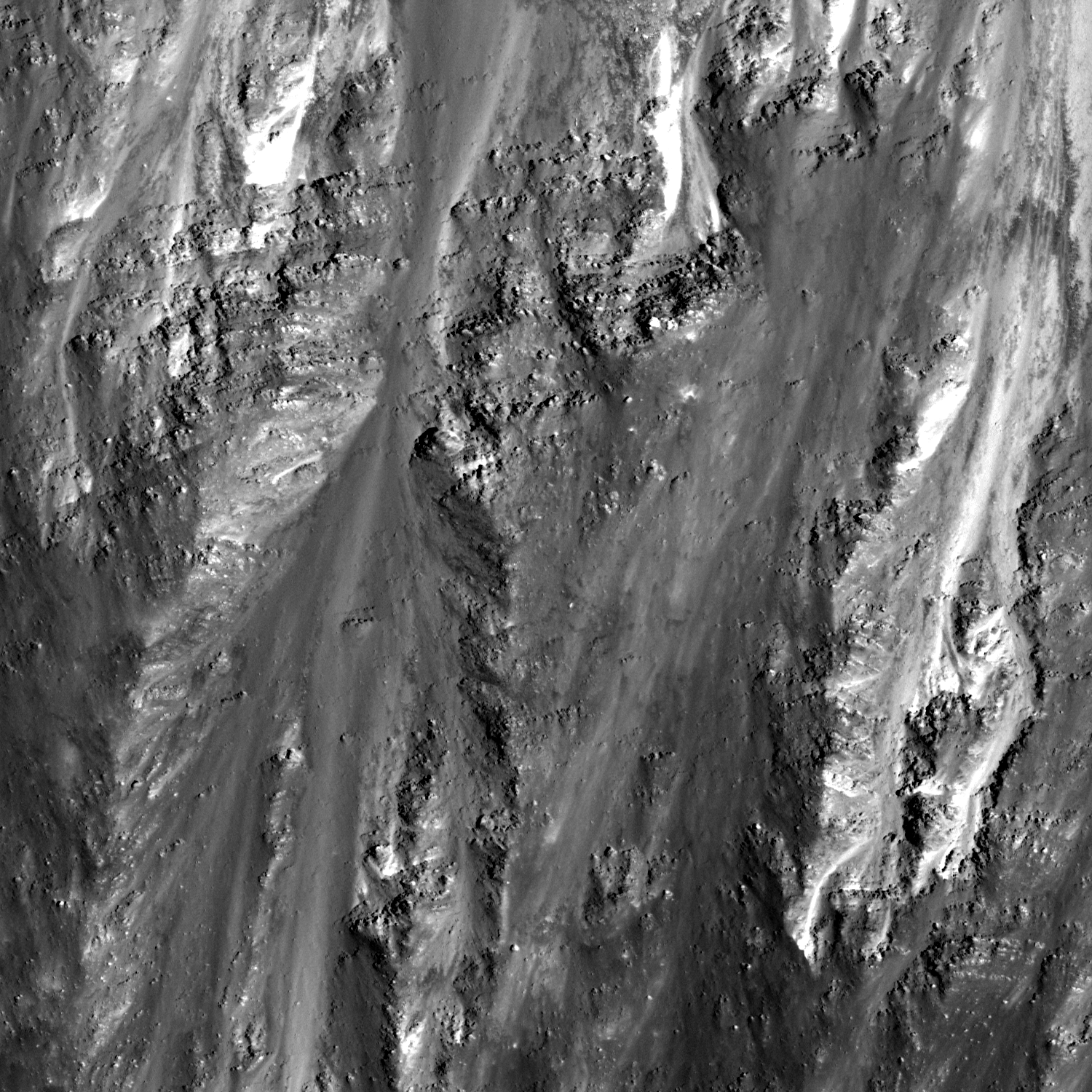
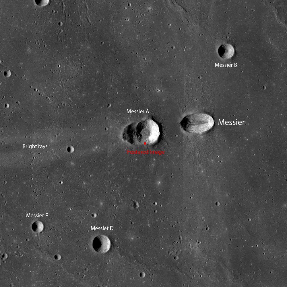
A portion of the LROC Global Wide Angle Camera (WAC) mosaic showing the Messier crater region of Mare Fecunditatis, with the LROC Featured Image for July 19, 2011 marked in red. Field of view is about 55 kilometers across. View the full-size LROC WAC labeled context image HERE [NASA/GSFC/Arizona State University].

Explore the full NAC frame here. What other features can you find? Additional examples of mare layering can be found. Look for layering in the flows of Bessel crater, Linne crater and in the walls of pit craters.

A slightly different angle on the LROC WAC Global Mosaic, and take, on Messier and Messier A with west at the top reveals to the eye the distinct texture of impact melt on the floor of Messier A and the landslide region on the crater's south interior wall (to the left). Through the NAC close-up (below) the impact melt appears to harbor more than one collapse pit [NASA/GSFC/Arizona State University].

Scattered among the debris on the impact melt covering the floor of Messier A are more than a few collapse pits, to the northeast of the location of the LROC Featured Image for July 19, 2011 [NASA/GSFC/Arizona State University].