Tuesday, October 9, 2012

Dynamics of Molten Rocks

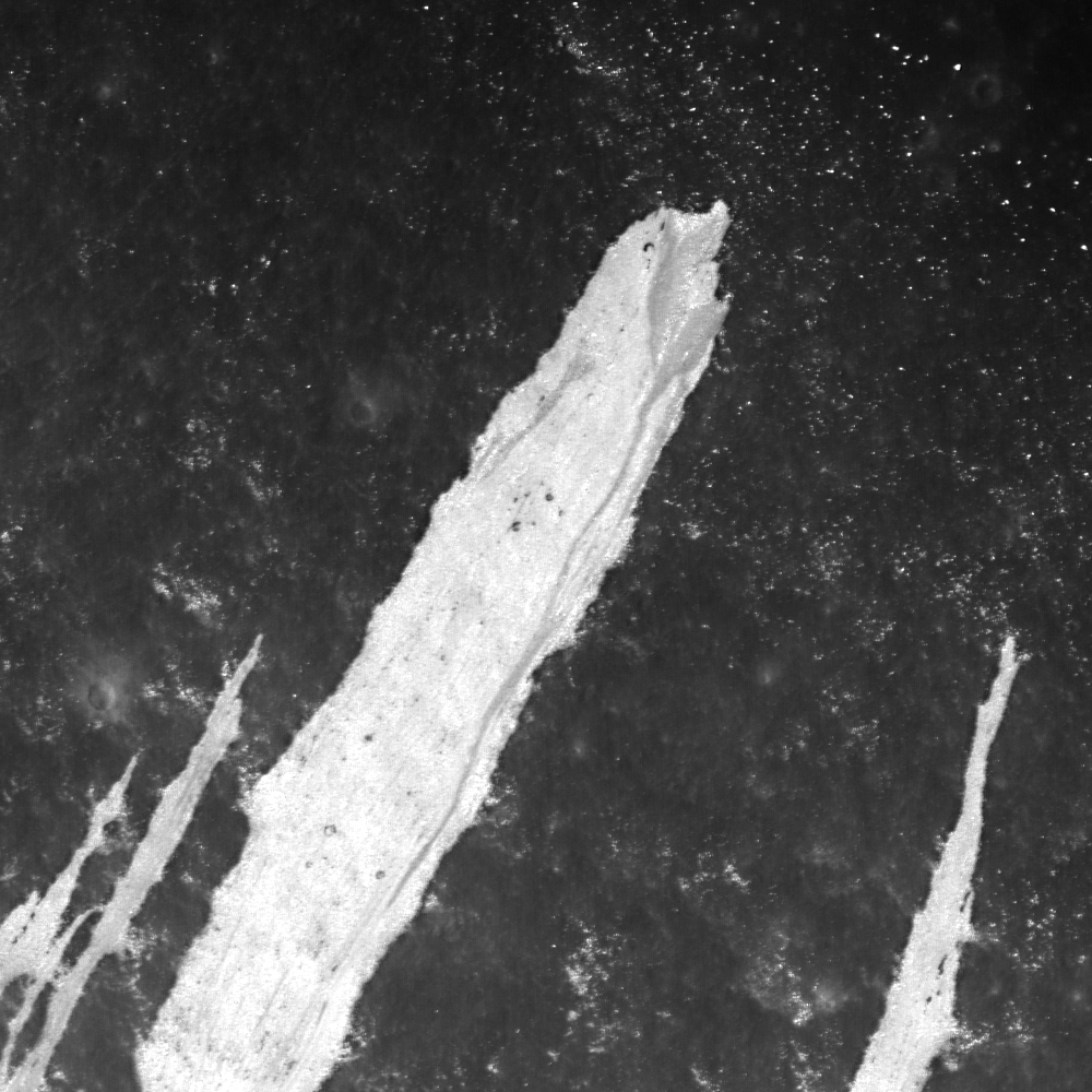
A portion of the impact melt near the western rim of Mandel'shtam F crater. Image centered near 5.130ºN, 165.822ºE, field of view width is 1182 meters. LROC Narrow Angle Camera (NAC) observation M189515239R , LRO orbit 12981, April 19, 2012; angle of incidence 31.98, full resolution 0.98 meters, from 120.3 km [NASA/GSFC/Arizona State University].
Hiroyuki Sato
LROC News System

Mandel'shtam F is a 15 km diameter crater located in the farside highlands. Along the western rim of this crater are several impact melt deposits formed from material splashed out of the crater cavity. The opening image highlights one such impact melt that flowed down the crater flank about 1.7 km.

Typically these impact melt-flow deposits are characterized with a meandering path, bifurcated distal edges, inflated relief, and levees. They resemble lava flows found in Hawaii or Iceland, but the generation process is completely different. The instantaneously-formed molten rocks from the anorthosite rich highland materials had cooled as they flowed downhill (and the melt viscosity increased). New NAC topographic and images acquired by LROC NAC enable us to examine the dynamics of these molten rocks (Denevi et al., 2012).

Mandel'shtam F crater and surrounding area in LROC WAC monochrome mosaic (100 m/pix). Image center is 5.07ºN, 166.00ºE. Blue box and yellow arrow indicate the locations of NAC footprint and today's Featured Image respectively [NASA/GSFC/Arizona State University].

Explore the impact melt flows at Mandel'shtam F in full NAC image yourself, HERE.

Related Posts:
La Pérouse A Impact Melt
Impact Melt Fingers
Impact Melt Lobes
Rootless impact melt flows
Look at that flow!
Out of the Shadows: Impact Melt Flow at Byrgius A Crater

Oblique Narrow Angle on Aristarchus Cobra Head

Oblique (-67.03° off nadir) view of sunrise within the deep interior of the famous Cobra Head of Schröter Valley on the Aristarchus Plateau. Field of view from a mosaic of both left and right frames of LROC Narrow Angle Camera (NAC) observation M177927543, LRO orbit 11357, December 7, 2011. The scene is centered near 25.2°N, 310.7°E (49.3°W)  [NASA/GSFC/Arizona State University].
A wider field of view from the same LROC NAC mosaic (the area outlined by the white rectangle is shown at full resolution in the opening image), the widest, deepest channel of Schröter Valley. Near the lower right corner of the rectangle is Tier 1 Constellation Region of Interest (ROI) Aristarchus 1 (24.56°N, 48.95°W) [NASA/GSFC/Arizona State University].
Full scope (small scale) rendition of the LROC NAC mosaic of the left and right frames of LROC NAC observation M177927543 [NASA/GSFC/Arizona State University].
The Cobras Head of Schröter Valley, with bright streaks of ejecta blown northwest from the Copernican Age impact that formed Aristarchus crater superimposed on a landscape at 3.1 billion years old. LROC Wide Angle Camera monochrome (643nm) observation M144944945C, spacecraft orbit 6494, November 21, 2010; angle of incidence 56.45° at 62.25 meters resolution, from 44.54 km [NASA/GSFC/Arizona State University].
The Cobra Head of Aristarchus Plateau in full sunlight, from the Hubble Space Telescope in Earth orbit, a 2005 release, "part of a larger examination of the links between lunar albedo and the geologic composition of the Moon's surface." [NASA, ESA and J. Garvin (NASA/GSFC)]
Dynamics of an apparently unusual oblique LROC NAC observation, captured as LRO was in low lunar orbit sailing 41 km over a point (24.84°N, 314.84°), about 120 km east of the area in the opening image field of view. Slewed to the west, the twin LROC Narrow Angle Cameras simultaneously imaged the areas outlined in blue, on the highest elevations of the Aristarchus Plateau [Google Earth/NASA/GSFC/USGS/JAXA/ASU].
Related Posts:
Aristarchus Spectacular! (December 26, 2011)
Old Man River (of Lava) (July 5, 2011)
Secrets of Schröteri (December 2, 2010)
The Colorful Moon (July 24, 2010)
Aristarchus - Up from the Depths (July 20, 2010)
LOLA's Aristarchus Plateau (April 2, 2010)
LROC: The Cobra Head (January 20, 2010)
LRO captures Aristarchus rille (August 18, 2009)
One more, for the road, 2007 HDTV still from 100 km over Oceanus Procellarum shows Aristarchus Plateau at an oblique angle, with the Cobra Head at full resolution seen in the inset, from SELENE-1 (Kaguya) [JAXA/SELENE].

Monday, October 8, 2012

Astrobotic unveils Polaris lunar rover design

Astrobotic's Polaris prospects for water at the lunar poles. With 3 vertical solar panels generating 250 watts and two radiator panels to shed excess heat, the Polaris design features stereo cameras and laser sensors to create 3-D video and digital models its surroundings. The robot communicates directly with Earth using a directional S-band antenna. Polaris will carry up to 70 kg in payload, i.e., core drill and science instruments to identify water content. Polaris is capable of autonomously traversal of permanently shadowed areas and will be equipped with variable height suspension for clearance or drilling angles. The suspension will maintains four-wheel ground contact without springs [Astrobotic Technologies, Inc.].
John Thornton
Astronbotic

Astrobotic today announced completion of a prototype lunar prospecting rover, Polaris, to search for water ice at the Moon's poles.  The rover will prospect for water, oxygen, methane, and other volatiles which could be useful for energy, supporting life, and producing rocket fuel.  "This rover is a first step toward using off-Earth resources to further human exploration of our solar system," said John Thornton, President. 

Polaris is specialized for drilling at the Moon's pole which is characterized by low glancing sun angles and operation near shadowed regions that can reach cryogenic temperatures.  The rover is tall enough to deploy a 4ft drill and produce 250W of power with solar panels oriented toward the Sun, which stays just above above the horizon.

Polaris, 1.63 meters wide and 2.4 meters long, can move at 30 cm a second on 60 cm-diameter wheels.  The rover weighs 150 kg, and will accommodate a drill and science instruments of up to 70 kilograms.

Computer vision determines the rover's position on the Moon within 3 meters. "It's game changing for lunar surface exploration and we're the ones to pursue it," said William "Red" Whittaker, CEO.  Without GPS, Polaris will match surface pictures with satellite imagery taken by NASA's Lunar Reconnaissance Orbiter (LRO) to determine its location on the Moon.

The rover features wheels and chassis beams constructed of light, tough composite materials.   The lighter structural materials minimize overall weight while accommodating the heavy drill and massive batteries required for this mission.

Astrobotic has won nine lunar contracts from NASA worth $3.6 million, including one to evaluate how Polaris can accommodate NASA’s ice-prospecting instruments during a 5k traverse near the Moon’s north pole.

Thursday, October 4, 2012

Byrgius A ejecta

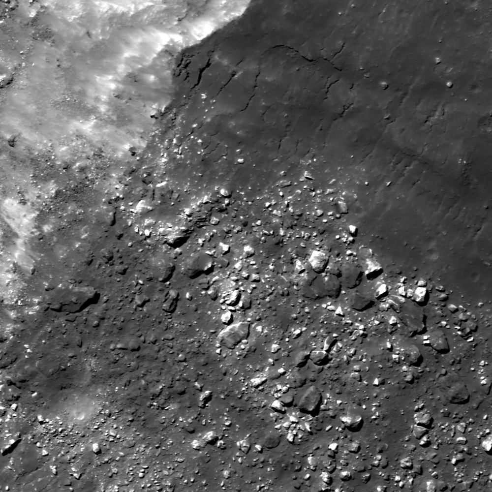
A mix of boulders and impact melt lie just beyond the rim of Byrgius A. 1000 meter wide field of view from LROC Narrow Angle Camera (NAC) observation M1101631740LE, LRO orbit 14676, September 7, 2012 [NASA/GSFC/Arizona State University].
Drew Enns
LROC News System

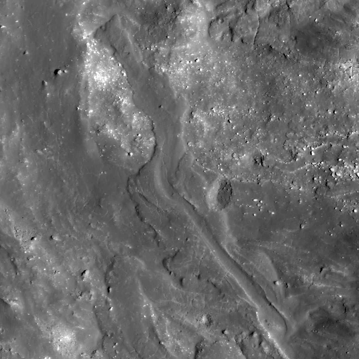
We have featured the impact melt flows of Byrgius A before, but today we are focusing on the ejecta. 

Above we can see that the ejecta blocks have a mixture of two reflectance levels. Maybe the impact is excavating two separate geologic units: one with low reflectance, and the other with high reflectance. 

Or, perhaps the bright, high reflectance ejecta blocks were covered by darker, lower reflectance impact melt. 

Can we figure out which hypothesis is correct?

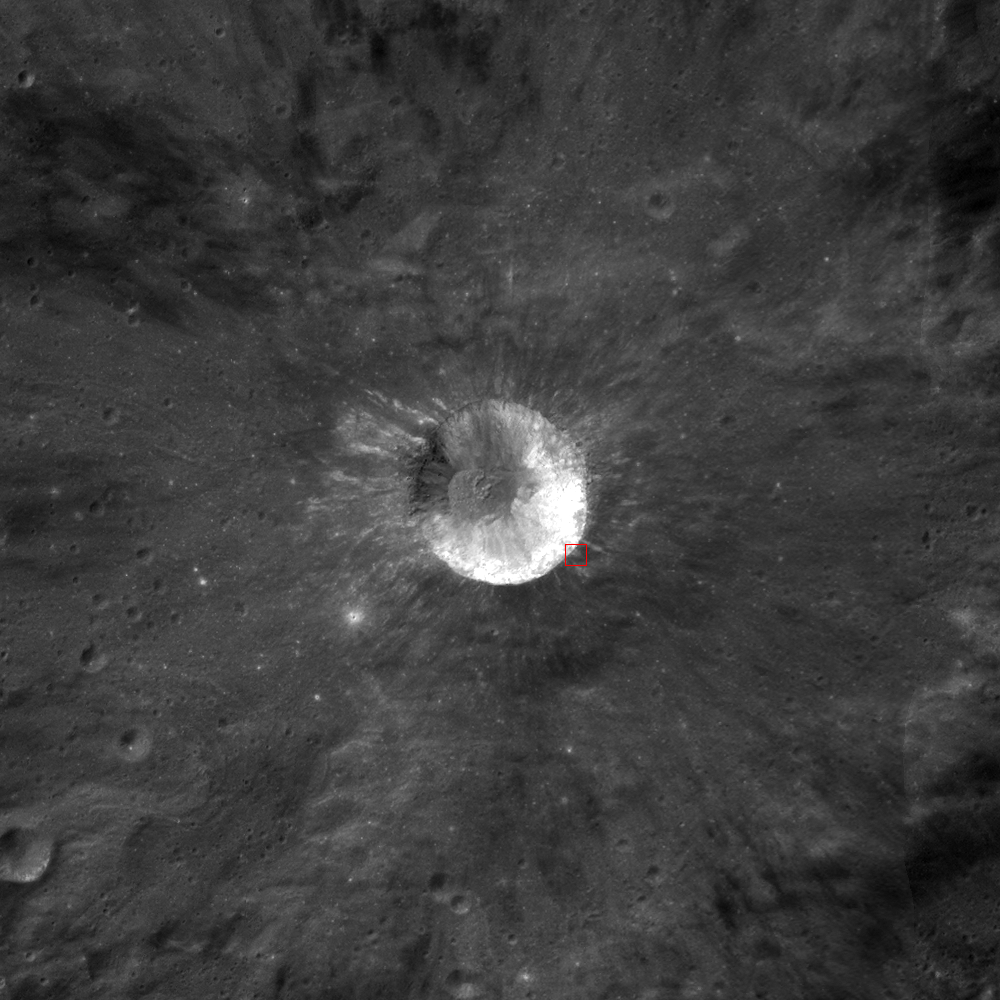
Outstanding LROC Wide Angle Camera (WAC) context image of Byrgius A (24.577°, 296.198° E). The subject of the LROC Featured Image, released October 4, 2012 is marked by the red box. Discontinuous bright streaks radiating from Byrgius A are boulder fields similar to the scene with that Featured Image. [NASA/GSFC/Arizona State University].
If the crater is excavating two different units, then we should expect to see nearby craters exposing the same. We don't see this in the context image. Several lines of evidence argue instead that impact melt covers some boulders: [1] the darker boulders have a similar reflectance to the impact melt, and [2] the dark boulders have pools of material.

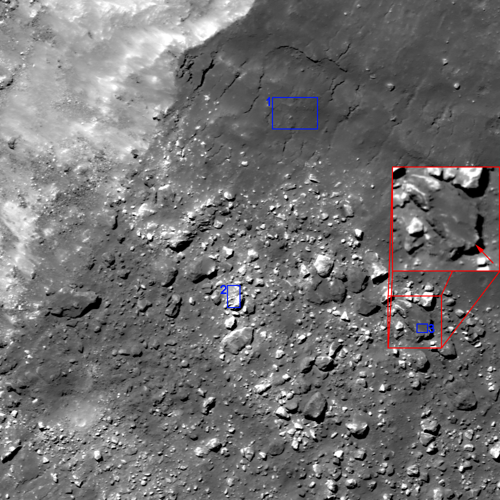
A more detailed view of the latest LROC Featured Image. Boxes show areas where reflectance was measured for: [1] impact melt, [2] a bright boulder, and [3] a dark boulder. The red box zooms in on a boulder covered by ponded dark material [NASA/GSFC/Arizona State University].
Nearby melt on the rim has formed a veneer over the original surface, and we can see the melt fracturing parallel to the crater rim. This veneer unit has a reflectance of 0.14, close to the dark boulders with a reflectance of 0.155. The bright boulders have a reflectance of 0.25. The dark boulders also have small ponds of material. Larger melt ponds develop in depressions exterior to their parent crater, and this is likely the same process operating on a small scale.

Can you test the hypotheses further with the full LROC NAC, HERE?

Related Posts:

Brygius A is often cited by naked eye observers, it's wide, bright ejecta field overpowering the southwestern limb from when the Moon is full through its later waning phases. From a spectacular mosaic of 20 images swept up by by ASTRONOMINSK, 2300 UT, September 3, 2012.

Geologically recent debris flow at Couder

A bright debris flow down the southwest wall of Couder crater (4.89°S, 267.45°E) shows signs of geologically recent activity. Note the two distinct units within the deposit (white and grey). Downslope is to upper right, and image field of view is is 1000 meters, from LROC Narrow Angle Camera (NAC) observation M1101817103RE, LRO orbit 14702, September 9, 2012 [NASA/GSFC/Arizona State University].
Drew Enns
LROC News System

Debris flows are common on crater walls.

Why?

Because the wall slope is close to the angle of repose, it doesn't take much energy to mobilize rocks to flow downhill.

Here, one large flow is surrounded by five thinner, shorter flows. Within the largest flow is a grey portion with a channel and triangular base. Why does the grey portion of the large flow have this shape?

Simulated view southeast across Couder, featuring the LROC Wide Angle Camera mosaic context image immediately below, draped over the Google Earth lunar terrain model.
Context image of today's Featured Image. Couder crater is located at 4.94°S, 267.43° E. Several bright flows are along the western interior of the crater. Field of view is 100 km [NASA/GSFC/Arizona State University].
Some sedimentary systems on Earth form a similar triangular shape. Rivers that empty into a larger body of water form deltas. Deltas form due to the change in the high energy to low energy environment when a river empties. The change in energy also reflects a change in depositional environment. The high energy of the river can carry more material, but a lake or ocean is less energetic and can't carry as much. The result: the material falls out of suspension and forms a delta.

Obviously, the Moon has no liquid water and thus no river systems, but a similar change in energy environments does occur here. Material in the channel travels down the crater wall from a source. When the debris flow loses enough energy and can not sustain its downward travel, the material is spread out and deposited across the surface in this similar deltaic shape!

Explore more of the debris flows in the full LROC NAC, HERE.

Related Posts:
Debris Flows in Gardner Crater

Early (April 2010) LOLA laser altimetry small-scale comparative elevation map of Orientale basin, with the location of 21 km-wide Couder marked at upper center [NASA/GSFC/LOLA].

Wednesday, October 3, 2012

Oblique views of Moon's highest and lowest places

East rim of 21 km Engel'gardt crater (5.69°N, 200.29°E), north of Korolov, basin on the Moon's farside, host to the Moon's highest elevation above the global mean (10,761 meters). LROC Narrow Angle Camera (NAC) M176265113LR, orbit 11111, November 18, 2011; foreground resolution 4.6 meters. A spectacular oblique observation, from spacecraft and cameras slewed -76.3° off nadir. Beyond the high point, first identified by Japan's Kaguya (SELENE-1), the east wall of Engel'gardt descends more than 4000 meters to the crater floor (not visible). View full-size and other versions HERE [NASA/GSFC/Arizona State University].
Searching through the catalog of LROC Narrow Angle Camera observations, it's difficult to find many images outside it's optimal straight-down 'push broom' design range, and fewer not already released as LROC Featured Images.

On a dare, I accepted a colleague's small wager (and his pocket change) and quickly found oblique LROC NAC observations of both the Moon's highest and lowest places. That was the easy part, because just as we discovered when we pieced together the rudimentary image in Taurus Littrow Oblique (September 29, 2012), squeezing, stretching and stitching together a huge, incredibly detailed final product of this kind is best left to the better-equipped.

Be that as it may, here is a partial result of those clumsy efforts, presented primarily because of the stark beauty of this side glance at "Engel'gardt Heights," the Moon's 10.761 km highest point. After deciphering the width and height scales the result was surprising.

Clearly, I only thought I fully appreciated all there was to see of what seemed to be a pretty bland landmark. Once again, that's the way the Moon works. You stare at a familiar feature for years, and then one simple change in perspective makes you wonder whether you ever really "saw" it all.

It became necessary to briefly review why this feature escaped our notice until the 21st century.

Dynamics of the slewed early lunar morning, oblique LROC NAC observation of Engel'gardt, during the 11,111th orbit of LRO, November 18, 2011. The spacecraft was well over 100 km away and over 40 km in altitude, and these facts help to explain the scope of the resulting field of view. X marks the spot of the Moon's highest place, in the left frame of the twin NAC observation. The correcting ratio of pixel width to height can largely be corrected. The upper half of the image reproduced up above, however, is, literally, bounded by "infinity," the dark of Space. Many objects appear higher in altitude than the Moon's "summit," because, even at a distance, LRO is looking "down" on the entire foreshortened field of view. Mountains in the distance really loom only over local terrain [Virtual Moon Atlas].
A glance through the Related Posts below will demonstrate that identifying the Moon's highest and lowest points has been discussed at length here and elsewhere, in recent years, perhaps because the Moon's true diameter, and the range of certainty as to its true center, moment of inertia, and actual shape were not narrowed to within two kilometers until very recently.

The final three Apollo "J" missions mapped large swaths of the sun-lit lunar surface with cameras operating in their patiently orbiting service modules, much of that work underway as the lunar module was away on the surface below. Unfortunately, the demands for lower Sun at their three landing sites meant the area of the Moon's farside with the highest elevations were rotating through the long lunar night. The totality of photography from all lunar missions, even the earliest, first views by anyone of the farside (just a little more than five decades ago) allowed for a low-resolution understanding of the stark differences between the Moon's near and far sides. Early on, it was already generally known where the Moon's highest elevations were, but a detailed survey would wait until lunar exploration again, albeit briefly, became the public policy of nations following the loss of Space Shuttle Columbia in 2003.

The lunar map available in Google Earth, though impressive in many places, reflects an earlier understanding of the area on the northeast frontier of the SPA basin long known to contain the Moon's highest places. The blue rectangle is the footprint of the left frame of LROC NAC observation M176265113L, used to build the lower portion of the oblique mosaic of the Moon's highest spot, on the wide eastern rim of Engel'gardt crater. The right-hand frame, bordered in part by sky, lacks official scaling instructions [NASA/JAXA/DOD/USGS/ASU/Google].
The Google Earth representation of the Moon is impressive in many places, though large areas still depend on 100 meter resolution albedo photography gathered by Clementine (1994), a component of that mission dependent on a high Sun. Without the more recent comprehensive Wide Angle Camera maps, subtle differences in relief go missing. And that's a fair illustration of at least part of the reason the magnificent high east rim of Engel'gardt crater went missing, and is still missing from the Google Moon elevation model.

Laser altimetry began with Apollo, advanced without needed "granularity" with Clementine and became nominally 'comprehensive' with the LALT laser altimeter on-board Japan's Kaguya. As the first long-duration lunar orbiter, launched together with LCROSS in 2009, advanced photo-mapping from LRO's LROC systems continues to marched our understanding at a faster pace than has yet to be achieved through its steadily growing database of LOLA laser altimetry. As a total mission, the very economical LRO mission may finally advance our understanding of the Moon to a point that matches most presumptions.

Repeated over-flights of LRO and its LROC Wide Angle Camera through an unprecedented time in lunar orbit, together with precise calculations of solar angles and distances, allowed for the rapid identification of elevations, complimenting the simultaneous build up of laser data points by LRO's LOLA. Under a mid-day Sun, the east rim of Engel'gardt seemed flat, but above, on December 9, 2009, with the Sun 21° over the east-southeast, LRO passed 59 km overhead as a bulbous shadow betrays the presence of a great height, in profile. Confirmation of Japan's discovery, with an only slightly adjusted elevation in meters, was only one of many achievements of the on-going Lunar Reconnaissance Orbiter mission. LROC WAC monochrome (604nm) data [NASA/DLR/GSFC/Arizona State University].
In truth, though it hasn't made the news, in our time the scientific world is adding more to our knowledge of the Moon each year than was learned throughout the 20th century. And that pace is likely to continue long after LRO is added to the list of artifacts of human activity on the Moon that it was, in part, sent to survey.

And, in truth, the reason the Moon's highest and lowest places were not known until more recently is more simply put. The highest of the Moon's high places (like Everest, on Earth) is a high place among high places, and the Moon's lowest place is a low place among many low places. Our knowledge of the Moon wasn't so much lacking as it was lacking granularity.

Point of Highest Elevation
By now, however, the LROC team at Arizona State has made the "east rim of Engel'gardt crater" not merely part of its WAC-derived global elevation models, but also a part of it growing list of NAC-derived localities, places with elevations mapped in fractions of a meter. Not satisfied with mapping more than half the lunar surface at high-resolution, a mind-boggling 3D model is taking shape.

"The Point of Highest Elevation" can be explored at 50 centimeter resolution, at the link on the left, or explore nearly 100 other areas of interest, at the LROC NAC DTM Viewer, HERE.

According the LROC Planetary Data System interface, unlike the still- significant part of the lunar surface not yet photographed at high-resolution through the LROC NAC cameras, the east rim Engel'gardt crater has been imaged, in either the NAC  left, NAC right, or both frames simultaneously 23 times, beginning June 4, 2010 (or after nearly a year after the spacecraft's arrival in lunar orbit. That's not to imply any neglect of other targets. The resource can't really be measured that way. But it is reasonable to conclude there is more than just a passing scientific interest in "the Roof of the Moon."

Until the release of this latest oblique view of the eastern side of Engel'gardt crater and points beyond, I confess to little more than a passing interest in this target. It seemed to lack something as intangible as a certain aesthetic quality. It seemed rather dull. But in the almost unnatural tight shot, captured from 48.16 km above a point on the lunar surface more than 100 km away, more than 6 degrees of longitude east, we have found our aesthetic.

Because it was captured from an altitude, and over an airless body, the area in the field of view seems typical of what's seen through a telephoto lens, with objects in the foreground gathered together and as much in focus as the distant high places well beyond and invisible from anywhere near the actual crater. As already mentioned, the scaling for the right frame of the NAC montage is essentially infinite, so beyond an imaginary line running north-south transecting the target crater, "objects may be further away than they appear."
This unnamed, largest crater on the floor of 178 km-wide Antoniadi (69.2°S, 186.94°E) is the location of the Moon's lowest point, 9094 meters below the Moon's mean elevation.The crater within a crater is, itself, well inside the Moon's largest (2600 km), deepest and oldest known impact, the more than 4 billion year-old South Pole-Aitken basin. Mosaic of both left and right frames from LROC NAC observation M191636857, orbit 13277, May 14, 2012; slew angle 63.8° [NASA/GSFC/Arizona State University].
Bonus image, also in the field of view from the Antoniadi NAC mosaic, the nearly flooded and comparatively diminutive central peak of Antoniadi, which was heavily inundated by melt long after it formed, demonstrating the marked differences between Antoniadi and similarly-sized craters elsewhere on the Moon. Some theorize Antoniadi may have been flooded from underground, following the energetic and relatively recent Orientalis basin-forming impact [NASA/GSFC/Arizona State University].
Then there's Antoniadi, about which much has already been written, and the subject of another LROC NAC oblique observation. So far, we've been unable to satisfactorily scale the entire image, but we do discuss two interesting fields of view from those frames immediately above.

Related Posts:
DLR: Flying over the three-dimensional Moon (December 1, 2011)
LROC's new Global Lunar Topography (November 16, 2011)
LOLA's deep Antoniadi (April 16, 2011)
LRO's unprecedented topography of the Moon (December 17, 2010)
Highest point on the Moon (October 26, 2010)
The deepest spot on the Moon nearly wasn't (September 17, 2010)
Lunar superlatives from LROC WAC (September 6, 2010)
The Moon's lowest of the  low (November 24, 2009)
Accurate topographic map of the Moon (June 13, 2009)
Spectacular refinements to Kaguya laser altimetry (May 28, 2009)
Best lunar topography derived from Kaguya (February 12, 2009)

The Moon's highest and lowest places, in relation to one another, the whole Moon's average elevation (the lunar equivalent to Sea Level here on Earth) in this very much resampled whole hemisphere view of the Moon's farside. Near center, beyond the rim of South Pole Aitken basin, is Engel'gardt crater, and the Moon's highest elevation, and near bottom, well-within SPA, is the largest crater within 178 km crater Antoniadi, site of the Moon's lowest elevation. The sites, representative of two very different places on the Moon, are only 2300 km apart, less distance than the major axis of slightly oblong SPA. LROC WAC DTM [NASA/GSFC/Arizona State University].

Tuesday, October 2, 2012

Secondary melt on the rim of Weiner F

A grooved surface is covered by a sheet of impact melt that has several parallel scarps. Two blocky craters superpose the melt and might be low velocity self-secondaries. LROC Narrow Angle Camera (NAC) frame M1097865095RE, illumination is from the southwest over a field of view 1500 meters across [NASA/GSFC/Arizona State University].
Drew Enns
LROC News System

The low afternoon lighting in today's Featured Image gives the impression that this surface has been sculpted or reshaped somehow.

When an impact occurs, ejecta is thrown out and can scour the exterior rim of the crater.

In this case, the scours are also covered by an impact melt veneer from the same event. Several parallel scarps in the impact melt imply that the melt was emplaced in discrete events.

How could this have happened?

A wider, roughly 4 kilometer-wide view of the interesting melt situated on the ledge within the wider rim of farside highland crater Weiner F [NASA/GSFC/Arizona State University].

LROC Wide Angle Camera (WAC) context image, with the location of the field of view highlighted in the LROC Featured Image released October 2, 2012 marked. Wiener F is located at 40.87° N, 149.91° E, WAC field of view roughly 58 km [NASA/GSFC/Arizona State University].
Impact melt is common in the interior of impact craters, covering the crater floor and crater terraces. Sometimes impact melt also sloshes over the rim of a crater, forming flows. In some cases, the ejected melt forms exterior melt ponds, and in the case of Wiener F an exterior melt pond has formed in an older crater! It is likely the exterior pond formed from several pulses of accumulating impact melt. As the impact melt sloshed around the crater interior, it repeatedly spilled out of the north rim, making several waves on its way down. Similar melt veneers are seen elsewhere on the Moon, such as exterior to King crater.

Explore more of the impact melt at Wiener F crater in the full LROC NAC, HERE

Related Posts:
King Crater's Unusual Melt Pond
Rippled Pond
Anaxagoras Exterior Melt

NASA Lunar Mapping and Modeling Project (LMMP) simulated southwestern perspective over Weiner F helps illustrate the distinctive topography inside and outside the farside highland crater. Is it possible Weiner F resulted from two craters, the second, and more recent offset to the south? [NASA/GSFC/LMMP/Arizona State University].

Sunday, September 30, 2012

Hit-and-Run Science

From 'A new hit and run Giant Impact scenario,' July 28, 2012;  Figure 1a: Five snapshots from the 30° impact angle and 1.30vesc impact velocity case (cC06) showing cuts through the impact plane. Colour coded is the type and origin of the material. Dark and light blue indicate target and impactor iron; Red and orange show corresponding silicate material. The far right shows the situation at the time of impact. At 0.52h, it can be seen how the impactor ploughs deep through the targets mantle and pushes considerable amount of target material into orbit. A spiral arm of material forms and gravitationally collapses into fragments. The outer portions of the arm mainly consist of impactor silicates and escapes due to having retained a velocity well above escape velocity. The silicate fragments further inward are stronger decelerated and enter eccentric orbits around the target. The impactor's iron core also looses much of its angular momentum to the outer parts of the spiral arm and re-impacts the proto-Earth. -  Figure 1b: The origin of the disk material highlighted, half a collisional timescale ( (Rimp + Rtar) / vimp ) after impact. In the grazing reference case (cA08), the majority of the proto-lunar disk originates from a spill-over of the impactor. In the head-on cases (cC01, fB06, iA10), much more material comes from the target mantle, being pushed out into orbit by the impactor core. Colours are identical to figure 1. Turquoise on the right shows water ice for the icy impactor case iA10. Reufer, et al. (2012) Icarus 221, 296
Paul Spudis
The Once & Future Moon
Smithsonian Air & Space

The origin of the Moon is a long-standing problem in planetary science.  Reconstructing complex events in the distant past is difficult and requires both knowledge and imagination.  The facts to be explained are relatively straightforward.  The Moon’s overall density (about 3.3 grams per cubic centimeter) and bulk chemical composition are about the same as that of the mantle of the Earth, suggesting a possible relationship between the two.  The idea that Earth and Moon are compositionally related is supported by the ratio of isotopes of oxygen in the lunar samples, which indicate that Earth and Moon are made from matter derived from the same region of the solar nebula (material that is compositionally distinct from that making up the various meteorite groups).  Finally, the Earth and Moon collectively have a very high angular momentum, mostly as a consequence of the high spin rate of Earth and the relatively large mass of our Moon compared to its primary planet.

Prior to the Apollo missions, three different models (capture, fission, binary accretion) vied for acceptance among the lunar science community.  The capture model proposed that the Moon formed elsewhere in the Solar System before a close, chance encounter resulted in the Earth capturing the Moon into orbit.  The fission model proposed that a large mass of molten material spun off a rapidly spinning early Earth, was thrown into orbit and over time, coalesced into the Moon.  The binary accretion model suggested that Earth and Moon assembled themselves independently as two distinct and separate bodies from the beginning.  None of these models seemed able to account for all the “constraints” mentioned above, but no one had any better ideas.

About 30 years ago, the problem of lunar origin was widely considered “solved” with the general acceptance of the Giant Impact model.  In this concept, four and a half billion years ago, the proto-Earth shared its orbit around the Sun with an object about the size of the planet Mars (dubbed Theia, in Greek mythology, the titan who gave birth to Selene, goddess of the Moon).  A chance encounter between these two planetoids resulted in their merging as the Earth-Moon system.  It was thought that a grazing (low angle) impact would serve to both spin up the Terra-Luna system, resulting in its relatively high angular momentum, and hurl vaporized mantle material from Theia into orbit around the Earth.  The disk of orbiting debris quickly coalesced into the Moon and this rapid accumulation resulted in the release of large amounts of heat, which proceeded to melt at least the outer few hundred kilometers of the Moon, creating an “ocean” of molten rock, or magma.

The Giant Impact model seemed to nicely account for most of the properties of the Moon.  But like many big ideas in science, the closer and longer we look at it, the more issues seem to arise.  It was long assumed that the Moon was made of material derived mostly from mantle of the impacting planet (Theia); in this view, the Giant Impact was really just a variant of the capture model.  As such, it did not explain either the chemical similarity of the Moon to the mantle of the Earth, nor their identical oxygen isotope compositions.  This objection was usually brushed away with the admonition that complications might be expected from planet-scale impacts.

A new set of computer models has looked at the consequences of a slightly more head-on planetary collision.  In contrast to the traditional oblique (few degrees) off-center Big Whack, researchers modeled the effects of an impact at about 30° incidence and relatively high velocity (about 1.3 times escape velocity, or roughly 14 km/sec).  They find that in this case, most of the material from which the Moon forms comes not from the impactor Theia, but from the mantle of the Earth.  This result might better explain the compositional attributes of the Earth-Moon system.  In fact, several models were run (slightly varying these conditions) and while none perfectly fit the chemical and dynamical constraints, this one matched them most closely.

While this modeling was underway, another group was analyzing the composition of isotopes of titanium in samples from the Earth, the Moon and meteorites.  The work has established that the chemical fingerprints that relate Earth and Moon are not merely close – they are virtually identical (to the best precision of the measurements).  The authors of this study claim that this result creates problems for the Giant Impact model, as that idea had called for most of the Moon to be derived from the mantle of the impacting planet Theia.  However, with the results of the new computer models of giant impacts discussed above demonstrating that the parameters of the collision can be adjusted to match the constraints on lunar origin, perhaps this is not such a problem for the Giant Impact model after all.

These developments should probably give lunar scientists pause.  After all, the Giant Impact model became popular because the earlier, traditional three models (capture, fission, binary accretion) were all inadequate and their boundaries and defining parameters had to be adjusted to permit their (barely acceptable) viability.  In other words, the models were stretched to fit any inconvenient facts or problem observations.  Now it appears that the same thing is happening to the new, “explains-it-all” Giant Impact model.  A scientific idea that can be stretched to fit any observable fact is not very useful as an explanatory principle – it is simply a glorified “Just So” story.  The late Karl Popper argued that often in science, an idea cannot be shown to be true, but it can always be shown to be wrong – that is, “falsified.”  If a hypothesis cannot be falsified, Popper argued, then it was not scientific. We need a mechanism in science to enable us to dismiss useless or irrelevant concepts and falsification is one way to do that.

So where does such philosophy leave the origin of the Moon?  Perhaps more knowledge and imagination is needed before we can pronounce lunar genesis a “solved problem.”

Originally published at his Smithsonian Air & Space blog The Once and Future Moon, Dr. Spudis is a senior staff scientist at the Lunar and Planetary Institute. The opinions expressed are those of the author and are better informed than average.

Related Posts:
A Sawtooth-like timeline for the first billion years of lunar bombardment (August 28, 2012)
A new 'hit and run' Giant Impact scenario (July 28, 2012)
"Our view of the Moon has turned upside down" (April 26, 2012)
Ti paternity test fingers Earth as Moon's parent (March 28, 2012)
NLSI team sheds light on 'late heavy bombardment' (February 28, 2012)
Spudis: Cataclysmic Conundrum (February 14, 2012)
'Significant change' in bombardment timing (January 6, 2012)
LOLA reveals distinct populations in bombardment record,
Diviner finds "no pristine lunar mantle" even within SPA
(September 16, 2010)
'The Grand Lunar Cataclysm and how LRO can help test it' (September 7, 2009)

Saturday, September 29, 2012

Taurus Littrow Oblique

An oblique perspective on the Taurus Littrow Valley and the landing site of Apollo 17 (20.1911°N, 30.7722°E) from more than 270 kilometers away. The granularity captured is remarkable testimony to the power of the LROC Narrow Angle Camera. LROC NAC frame M192703697R, orbit 13427, May 26, 2012; spacecraft and camera slewed 56.09° from nadir, resolution 2.79 meters, from a point 131.29 km over 20.01°N, 38.78°E [NASA/GSFC/Arizona State University].
Joel Raupe
Lunar Pioneer

The eleventh, and most recent, release of Lunar Reconnaissance Orbiter Camera (LROC) photography to the Planetary Data System (PDS) might have passed unnoticed. The spacecraft, after all, has been orbiting the Moon for more than three years, presently at more than 100 km, as it has since the beginning of 2012, and a year has passed since the spacecraft's dramatic 22 kilometer barnstorming passes over the surface in late 2011. 

The nominal mission orbiting altitude of 40 to 60 kilometers could not be sustained forever, though certainly none have come closer to mastering the Moon's 'lumpy' gravity well than LRO's flight directors.

Results from this mission-conserving, more apparently sedate higher-altitude phase in the LRO extended science mission would not very dramatic, still covering the same ground, over and over, presently from a greater distance. But, as all who regularly observe the Moon from Earth already know, the Moon never seems to present the same face twice, and it always seems to deliver up to patient, alert and modestly equipped observers a new face each and every time they pause to take a look. Remarkably, this axiom is proving as true for LRO in polar orbit as it is for Earth-bound observers 400,000 km away.

For the moment, 'barnstorming' has been left to the GRAIL twins. Together with LRO and the ingeniously recycled ARTEMIS probes, the feast of having five U.S. space vehicles in lunar orbit simultaneously cannot compete with Curiosity on Mars, or Dawn and its departure from Vesta for Ceres.  Even after four decades of near-neglect, as happened in the Apollo era, even hardened lunatic fanatic followers of LRO, quite naturally, have a more difficult time sustaining their sheer awe of the stunning, long overdue mission.

When properly scaled, the now-distinctive, albeit brief, trace of human activity on the floor of Taurus Littrow Valley is just barely visible at the center of this frame, pushed to 200 percent. Though the Apollo 17 lunar module descent stage cannot be seen, the darker material once just below the surface around that artifact, as well as the path to and from the ALSEP and LRV sites, turned over by the feet of Gene Cernan and Jack Schmitt nearly 40 years ago, is definitely a part of this landscape, photographed from an incredible distance last May [NASA/GSFC/Arizona State University].
Though the announcement of this eleventh PDS release seemed slightly delayed observations collected by LRO cameras from mid-March through mid-June was already available, right on time, through Arizona State University's LROC PDS interface. You had to have coordinates of a chose piece of the Moon's surface enumerated, longitude and latitude of its meets and bounds, unless patient or idle enough to scroll through sequential, lossy thumbnails.

Soon after the formal announcement, however, updated and detailed LROC NAC and WAC observation footprints became available to users of Google Earth, and as a layer on the web-based LROC QuickMap. The latter publication allowed the lay-public to experience something of the kind of serendipity only selected scientists experience when they comb through its latest pictures.

At around 30 percent full resolution, the breadth of Taurus Littrow can be seen, the rectangle tracing the outline of the narrow field of view shown at 100 percent resolution in the opening image, further above. Almost the entire area, the now-familiar landmarks, explored by Cernan and Schmitt can be seen. LROC NAC M192703697R [NASA/GSFC/Arizona State University].
Not long after these releases, every 90 days, someone who deserves a distinguished medal uploads to the Washington University (St. Louis) web-servers carefully updated Google Earth Keyhole Markup Language (KMZ) LRO-derived NAC and WAC footprint files. 

And though the lunar map available using Google Earth is increasingly outdated, after loading selected, updated KMZ files users can sift large areas of the lunar surface with LROC NAC and WAC observational fields of view embedded, and with an adjustable sliding time scale. It's a great way to get a quick look at areas available at high-resolution and during a particular phase of the mission, each with different illumination angles, especially any newly available observations of a particular area of personal interest.

Another demonstration of LROC NAC capabilities. The footprints, the 'fields of view.' of LROC NAC observations M192703697R and M192703697L, set up much as an imaginary passenger on board the Lunar Reconnaissance Orbiter might have seen the Target of Opportunity with the naked eye, in polar orbit 133 kilometers over a point on the Moon about 245 km east of the Apollo 17 landing site in Taurus Littrow Valley. Both field of view are well within the Apollo corridor, and the Apollo metric camera interferometry elevation model, integrated into the Google Earth virtual Moon [NASA/GSFC/USGS/JAXA/ASU].
It's also a way to allow the eye to "pick a crooked stick out from a pile of straight ones," because the occasional oblique observation shows up quite naturally as a highly elongated footprint that stands out sharply from the regular course of straight north-south footprints that follow the LRO polar orbit.

A highly-reduced copy of a 9240x7930 pixel mosaic of nearly the entirety of both the left and right frames of LROC NAC observation M192703697. Unfortunately, the original image file weighs in at around 66Mb, probably too hefty for most people's immediate resources. It's unfortunate because so very much spectacular detail and "knowledge to be gained," some of it important to our improving picture of lunar morphology, can be seen in the jaw-dropping original. You can, if you have the bandwidth, download the unofficial mosaic HERE [NASA/GSFC/Arizona State University].
Just a quick survey, one of many routes into the wealth of data that is still being swept-up by the LROC cameras, uncovered a new oblique observation of Taurus Littrow (sampled in this post).

Though the landing site of Apollo 17 has been explored at high-resolution by LRO many times, is readily identified through modest telescopes, and has even been surveyed by Hubble, even up close the Moon deliveres on a well-earned reputation for new glory with even simple changes in camera perspective, as most recently at even medium resolution from LRO last May.

Even the distinct trace of human activity, from December 1972, can be picked out, together with the enduring Sculptured Hills, the bright dusting of material blown off South Massif by the impact that formed distant Tycho, and so forth. But is this latest really a unique perspective, or the first time Taurus Littrow has been photographed from the east?

The full-resolution M192793697LR mosaic (warning: 66mg) may be available, HERE.

Certainly the last time Taurus Littrow was photographed from the east before the arrival of Apollo 17.  On December 11, 1972, after separating from Ron Evans and the Command Module America (visible at center), in their 12 orbit and just prior to final descent, Gene Cernan shot a short series of pictures of the destination from his left window of the lunar module Challenger. At full resolution, comparing AS17-147-22465 with the M192703697LR mosaic reveals how little the landscape has changed.
Not quite. But, though hand-held camera shots by Gene Cernan were captured from much closer and from lower altitude, the LROC NAC mosaic seen in miniature above, under similar lighting conditions, shows advances in photography in four decades, much of it a direct result of manned and unmanned space exploration.

In time, its possible that a small impact may have left behind a large enough trace to show when comparisons are made between the LROC NAC mosaic and frames from Apollo 17 Magazine 147. Its even possible, perhaps, that a change in perspective will eventually allow us to discover the final resting place of the Apollo 17 lunar module ascent stage itself, which was intentionally impacted near South Massif after being jettisoned, just before the last Apollo lunar mission broke orbit and returned to Earth.

Related Posts:
LRO LAMP sharpens Apollo surface helium data (July 17, 2012)
Toxicity of Lunar Dust (July 2, 2012)
39 Years (and counting) (December 14, 2011)
Just another crater? (December 13, 2011)
Apollo metric camera maps completed (November 21, 2011)
Too brief an expedition to a lobate scarp (August 24, 2010)
Moon geologically active, cooling and shrinking (August 19, 2010)
Return to Moon, Schmitt says, important for protection of liberty (June 17, 2010)
Dr. Jack Schmitt salutes LROC's Mark Robinson and the LRO
camera team at Arizona State
(November 10, 2009)
Apollo 17 from 50 kilometers (October 28, 2009)

Thursday, September 27, 2012

LROC: Nectaris Diversity

A variety of textures and reflectivities in the wall and floor of a recent crater within the ghost crater Daguerre in Mare Nectaris (11.9°S, 33.6°E). North is up; illumination is from the west, downslope is toward the top of the frame, field of view 425 meters, from LROC Narrow Angle Camera (NAC) frame M174665969R, spacecraft orbit 10874, October 31, 2011; incidence angle 39.33° at 0.65 meters resolution from 63.53 kilometers [NASA/GSFC/Arizona State University].
James Ashley
LROC News System

Today's Featured Image was chosen to showcase the extraordinary range in surface textures and albedo possible within a small area (half a kilometer square) on the Moon.

Prior to Narrow Angle Camera (NAC) imaging, the low-reflectance wedge along the southern rim was generally regarded to be an impact exclusion zone. Such a zone results when a bolide on a low-angle trajectory produces a heterogeneous energy distribution that unevenly deposits its excavated ejecta. The reason for assuming this can be seen in the Wide Angle Camera (WAC) mosaic image below (two frames down), where a prominent wedge shape is visible.

At the NAC scale, however, it is clear that low-albedo material has cascaded into the crater. This then became juxtaposed with blocky debris on the crater floor with patches of fine-grained deposits intermixed. Is the wedge-shaped ejecta truly the result of an uneven energy distribution, or was ejecta simply darker in the southern direction -- perhaps resulting from a buried layer of darker deposits exposed and ejected by the blast? What clues could help us resolve the question? A geologist explorer on the ground would be tempted to draft a map of these different deposits. Would such a map be useful for finalizing our conclusions?

The white square depicts the Featured Image field of view within a wider (2.17 km) context NAC image [NASA/GSFC/Arizona State University].
Also, before the Narrow Angle Camera captured these images, it was unknown whether the dark material was a dry debris flow or impact melt. What about the NAC image allowed us to solve this puzzle with confidence?

LROC Wide Angle Camera (WAC) global 100 meter mosaic on LOLA elevation model (NASA LMMP ILIADS application) shows the high-reflectivity of the ejecta pattern surrounding the impact and an intersecting ray that appears to have originated with the impact that formed Mädler crater, off toward the west-northwest [NASA/GSFC/LMMP/Arizona State University].
Click HERE to explore the full NAC image frame. Other examples of recent impacts can be found in Ejecta Starburst, Recent Impact in Oceanus Procellarum, and Rubble Pile on Fresh Crater Floor.