Showing posts with label angle of repose. Show all posts

Thursday, January 16, 2014

Slump or Slide?

Rock and debris slumped from northwest to southeast (upper left to center) and cascaded into the floor of a linear topographic low (depression or graben) near Milichius crater; arrows indicate the direction of movement. 1.2 km field of view from LROC Narrow Angle Camera (NAC) observation M190794864L, spacecraft orbit 13160, May 4, 2012; 46.88° incidence angle, resolution 1 meter per pixel from 122.34 km [NASA/GSFC/Arizona State University].
J. Stopar
LROC News System

A linear topographic low (a depression or graben) located southeast of Milichius crater (9.342°N, 330.646°E) shows tell-tale signs of mass wasting, the ongoing process of erosion that levels out surface topography (see figure below). A large mass movement, more than 1 kilometer across, eroded part of the depression wall near its southwest end (see opening image). Unlike the example of mass wasting highlighted in Tuesday's Featured Image of Schubert A crater (January 14, 2014), which resulted from many small individual rock movements, this material likely moved as one large unit. Was this the result of a landslide or of a slump? Understanding how landforms erode tell us about their properties including angle of bedding planes, composition (such as rock or soil), and mechanical properties such as shear strength (the ability to resist downslope movement).

Slightly wider field of view, showing the segment of the linear depression, from LROC NAC M190794864L [NASA/GSFC/Arizona State University].
Landslides involve rock and debris moving downslope along a planar surface, whereas slumping usually occurs along a curved interface and as a single large unit. Slumps are commonly observed in large impact craters, including Giordano Bruno, Darwin C, Klute W, Milne N, and Steno Q.

The depression with the nominally contiguous length to the northeast is visible at the center of this 34 km field of view from LROC Wide Angle Camera observation M129486143CE, orbit 4215, May 26, 2010, 56.85° incidence angle, resolution 58.3 meters from 41.48 km [NASA/GSFC/Arizona State University].
Additional context in this 74 km field of view, from the same LROC WAC observation stitched together with a similar observation of the same latitude during the sequential orbit, shows the significant bright ray debris from Kepler, to the west, and Copernicus, to the east; both outside this frame. 12.19 km Milichius crater is at upper left and 3.76 km Milichius K is above lower left [NASA/GSFC/Arizona State University].
The example near Milichius crater, however, does not occur in a large impact crater. Yet, the segmented arcuate faults near the head of the material (upper left of opening image) are similar to those of slumped materials in impact craters. Arrows point toward the end of the material, or toe, where rock and debris has come to rest in the floor of the narrow (roughly 1.5 km wide) linear depression. High-resolution NAC stereo imagery of this area would be useful in order to better constrain the morphology of this material and allow us to better differentiate between a landslide or a slump.

Explore the full NAC image, HERE, to look for more landslides in this area. Which of these is likely to be of a much older age?

Related Posts:
Aristarchus Plateau 1 Amazing Geologic Diversity
Fresh Copernican Crater
Rim on a Rim
Rock slide in Rima Hyginus

Wednesday, November 13, 2013

Debris flow down the wall of Dugan J

M1131216329LR_thumb-1000x1000
Southeast wall of Dugan J, where material flowed downward and came to rest at the base of the crater wall. Field of view is approximately 2 km across. From LROC Narrow Angle Camera (NAC) mosaic M1131216329LR, an oblique observation swept up during LRO orbit 18833, August 15, 2013; resolution roughly 3 km per pixel [NASA/GSFC/Arizona State University].
H. Meyer
LROC News System

The farside crater Dugan J (roughly 13 km in diameter, 61.458°N, 107.898°E) is located northeast of Compton crater and well east of the marginally near-side Mare Humboldtianum.

Dugan J is a fresh, simple crater, which is why it appears crisply bowl-shaped and with steeply sloping walls in the LROC NAC oblique image, further below.

In that mosaic, notice the subtle surface expression of a filled crater in the foreground of the oblique image. This nearly 23 km diameter crater is almost unrecognizable because it is filled to the brim with ejecta from nearby impacts, including Dugan J. That's a lot of ejecta!

M1131216329LR-1600x736
Dugan J - In an oblique, relatively low resolution LROC NAC mosaic [NASA/GSFC/Arizona State University].
In the opening image, low-albedo material rests on the southeast wall. Unlike flows of liquid impact melt in craters, the flow observed above is composed of fine-grained, granular debris originating from the crater walls that acted like a fluid as it was pulled downslope by gravity.

Granular debris flows are common in fresh craters, where the walls are steeply sloping, promoting downhill movement of eroded material from high up on the crater walls to the crater floor. Over time, the walls degrade and shallow out. When their slopes reach the angle of repose (for the Moon: near 30° from horizontal), it becomes more difficult to move material downslope. However, if the slopes are disturbed by forces in addition to gravity, such as seismic shaking from a nearby impact, material can still be mobilized.

WMS-Dugan_J-context-580x902
LROC Wide Angle Camera (GLD100-WAC) mosaic showing Dugan J in context. The field of view from which the LROC Featured Image was cropped is designated by the yellow, dotted quadrangle, and two filled near-ghost craters are circled by orange circles. The black ellipse denotes the location of the Compton-Belkovich (Th anomaly) volcanic complex. Compton crater is approximately 164 km in diameter [NASA/GSFC/Arizona State University].
The granular flow appears to have originated from near the rim of the crater, where low-albedo material can be seen streaking the high-albedo crater wall. There is also some wall material external to the flow in Today's Featured Image that has been degraded and has started to cover part of the floor with rubble. The floor of Dugan J is covered in impact melt and blocks that are being worn into boulders.

Check out the full resolution NAC oblique image, HERE.

Related Posts:
Clerke crater (September 5, 2013)
Love U, on the farside of the Moon (June 26, 2013)
Rim Slumping inside pre-Nectarian Gamov (April 12, 2013)
Debris Flows in Kepler crater (February 6, 2013)
Debris flow at Clavius E: How Recent? (October 18, 2012)
Lunar landslides (October 15, 2011)
Top of the landslide of La Pérouse A (September 20, 2012)
Giant flow of Tycho impact melt (August 14, 2012)
At the top of an avalanche in Langrenus (October 7, 2011)
Dry debris or liquid flow? (June 3, 2011)
Impact melt at Epigenes A (October 24, 2009)

M169772751RE-NSJ-04-1-580x800
From a Draft Set of LROC NAC Debris Flow Images, a spectacular fresh landslide of exceedingly fine "fines," down the west-southwestern wall of Copernican crater Fechner T (58.7°S, 122.76°E). LROC NAC mosaic M169772751LR, LRO orbit 10153, September 4, 2011; 60° angle of incidence, resolution less than a half meter per pixel from 55 km [NASA/GSFC/Arizona State University].

Thursday, October 4, 2012

Geologically recent debris flow at Couder

A bright debris flow down the southwest wall of Couder crater (4.89°S, 267.45°E) shows signs of geologically recent activity. Note the two distinct units within the deposit (white and grey). Downslope is to upper right, and image field of view is is 1000 meters, from LROC Narrow Angle Camera (NAC) observation M1101817103RE, LRO orbit 14702, September 9, 2012 [NASA/GSFC/Arizona State University].
Drew Enns
LROC News System

Debris flows are common on crater walls.

Why?

Because the wall slope is close to the angle of repose, it doesn't take much energy to mobilize rocks to flow downhill.

Here, one large flow is surrounded by five thinner, shorter flows. Within the largest flow is a grey portion with a channel and triangular base. Why does the grey portion of the large flow have this shape?

Simulated view southeast across Couder, featuring the LROC Wide Angle Camera mosaic context image immediately below, draped over the Google Earth lunar terrain model.
Context image of today's Featured Image. Couder crater is located at 4.94°S, 267.43° E. Several bright flows are along the western interior of the crater. Field of view is 100 km [NASA/GSFC/Arizona State University].
Some sedimentary systems on Earth form a similar triangular shape. Rivers that empty into a larger body of water form deltas. Deltas form due to the change in the high energy to low energy environment when a river empties. The change in energy also reflects a change in depositional environment. The high energy of the river can carry more material, but a lake or ocean is less energetic and can't carry as much. The result: the material falls out of suspension and forms a delta.

Obviously, the Moon has no liquid water and thus no river systems, but a similar change in energy environments does occur here. Material in the channel travels down the crater wall from a source. When the debris flow loses enough energy and can not sustain its downward travel, the material is spread out and deposited across the surface in this similar deltaic shape!

Explore more of the debris flows in the full LROC NAC, HERE.

Related Posts:
Debris Flows in Gardner Crater

Early (April 2010) LOLA laser altimetry small-scale comparative elevation map of Orientale basin, with the location of 21 km-wide Couder marked at upper center [NASA/GSFC/LOLA].

Tuesday, June 26, 2012

LROC: Giordano Bruno, The Big Picture

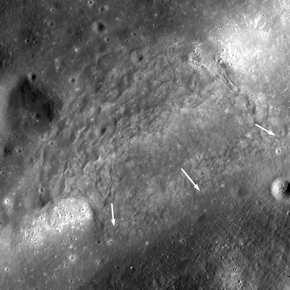
Mosaic of eight LROC NAC images provides this spectacular view of the interior of Giordano Bruno crater (21 km diameter). Resolution was reduced by 10 times to fit this Featured Image format, M185212646LR, M185219795LR, M185226944LR, M185234092LR. View the spectacular 1215 x 1215 px LROC Featured Image HERE [NASA/GSFC/Arizona State University].
Mark Robinson
Principal Investigator
Lunar Reconnaissance Orbiter Camera
Arizona State University
 
To conserve fuel, LRO was moved from its 50-km circular orbit into an elliptical orbit on 11 December 2012. As a result the spacecraft's altitude is now significantly higher in the northern hemisphere; the low point of the orbit is ~30 km over the south pole and 200 km over the north pole. This new orbit provides fantastic opportunities to acquire large area mosaics with nearly identical lighting across numerous orbits. For this Giordano Bruno crater mosaic, LROC acquired four NAC pairs (8 NAC images), from 4 orbits in a row, over a six hour period on 1 March 2012. Since LRO's polar orbits progress from east to west, the first image pair was acquired by slewing the spacecraft 6° to the west, on the next orbit only 1° to the west, on the third orbit LRO slewed 4° to the east, and the last orbit 9° to the east. The pixel scale of the images was about 1.6 to 1.8 meters, so the the images were reprojected to 1.8 meters.

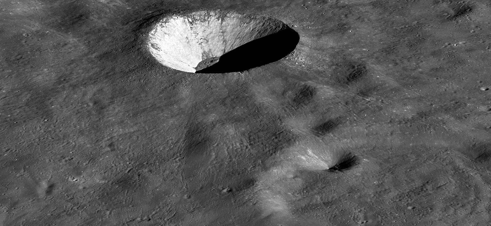
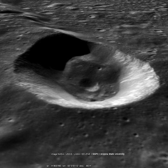
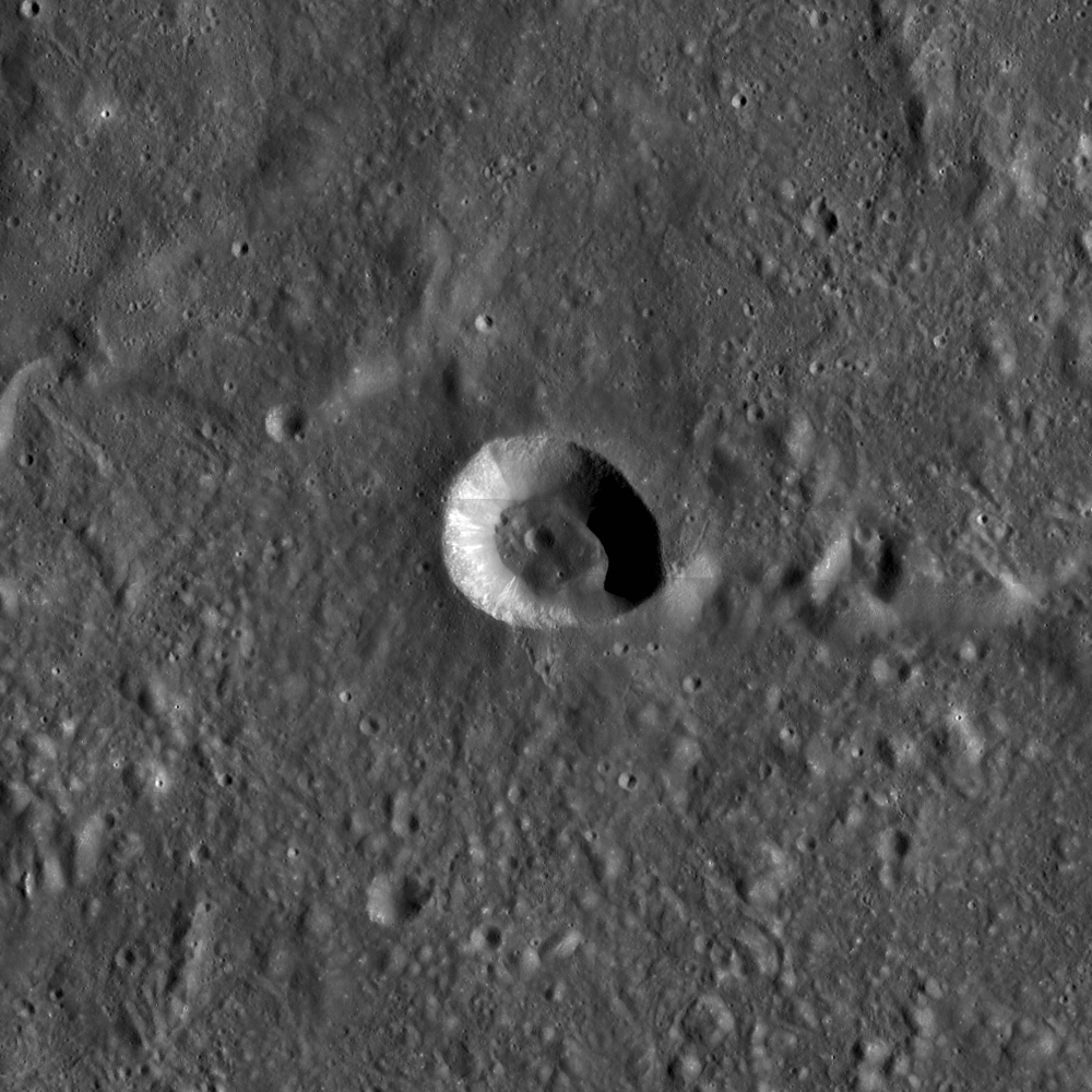
How did Giordano Bruno (35.92°N, 102.74°E) crater form, how big is it, and when did it form? The first question is easy: it formed as the result of a hypervelocity impact of a comet or asteroid into the Moon. The crater is irregularly shaped, so its diameter ranges from about 20.9 km to 21.6 km (13.0 miles to 13.4 miles). Its walls are very steep and the floor is a mix of jagged boulders and pooled impact melt rock. Since LROC has an ability to collect stereo observations, we now have a high-resolution topographic map of the whole crater made from images acquired when LRO was in its lower orbit (50 cm resolution).

Northeast corner of Giordano Bruno crater with LROC NAC topographic contours (at 100 meter intervals) overlain. Explore the contour map of all of Giordano Bruno crater HERE and see the 900 px context image HERE [NASA/GSFC/Arizona State University].
The NAC topography reveals that the walls everywhere have over 2000 meters of relief, and the northwest side of the crater has more than 2800 meters of relief. Everywhere the wall slopes exceed 30°, which is very near the angle of repose. However, in the upper portions of the walls the slopes are 40° or more. Slopes this steep can only be supported by solid material, not loose debris. Over time smaller impacts will erode the upper walls, and all slopes will be at or less than the angle of repose as the walls literally crumble. In the topographic map (above) you can also see a large bench that represents a block of wall material that slumped into the crater, but stopped about two thirds of the way down. That bench used to be at the same level as the rim, some 1500 meters up the wall!

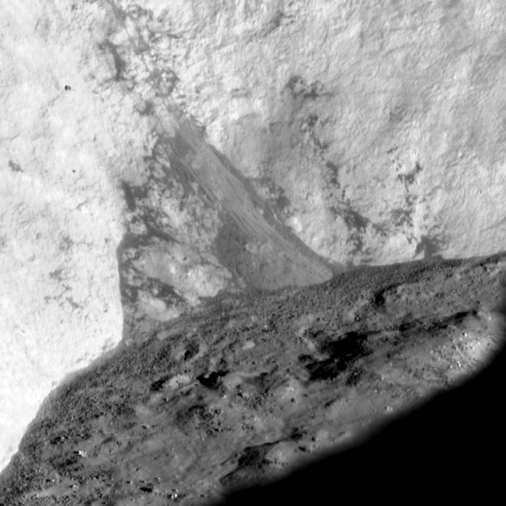
Impact melt flow on south flank. View the original field of view HERE [NASA/GSFC/Arizona State University].
How old is this beautiful crater? The answer is very young, but how young? We won't know the answer for sure until we obtain a sample of impact melt and can make precise radiometric age dates. The sharp, well preserved nature of the melt forms on the crater floor and flanks (above) and the sparsity of superposed craters show us that the crater is young. Scientists have counted the number of craters to estimate an age of 10 million years, or less. However with craters this young we do not know how many of the few craters that we can see were actually formed as self-secondaries: late stage material ejected from the event that formed the crater and fell back on the newly formed ejecta. These self-secondary craters, if they exist in abundance, would lead to an estimated age that is older than the true age, if not accounted for in the crater statistics.

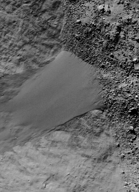
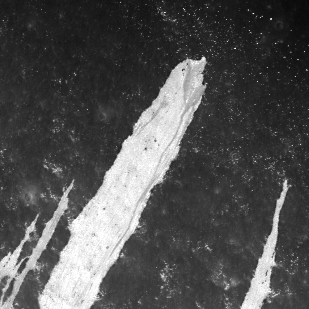
Enigmatic dark ejecta on north flank. View the wider field of view, HERE [NASA/GSFC/Arizona State University].
Many fascinating details are revealed both inside and outside the crater in the NAC images. What is the dark rubbly material that occurs in discrete patches on the rim (above)? Could it be material from basaltic dikes excavated from depth and ejected up onto the rim? Or perhaps impact melt glass? This question may remain outstanding until astronauts traverse the rim of this spectacular crater. Imagine standing and looking across a 2500 meter (8200 feet) deep crater to the far wall some 21 km (13 miles) distant. For comparison the Grand Canyon is only 1800 meters (6000 feet) deep, but is a bit wider at 29 km (18 miles). Which would be more impressive? I am not certain, but I would certainly like to find out!

Examine this full resolution (1.8-meter per pixel scale) mosaic of Giordano Bruno HERE.

Giordano Bruno mosaic with NAC stereo derived contour lines, HERE.

Previous LROC Giordano Bruno Featured Images
Outside of Giordano Bruno
Fragmented Impact Melt
Delicate Patterns in Giordano Bruno Ejecta
Impact Melt Flows on Giordano Bruno
Young Giordano Bruno 

LROC Wide Angle Camera (WAC) Observation M121539469C (604nm), LRO orbit 3045, February 23, 2010; Angle of incidence 49.62° at 76.2 meters per pixel resolution, from 54 kilometers [NASA/GSFC/Arizona State University].