Showing posts with label Taurus-Littrow. Show all posts

Wednesday, December 19, 2012

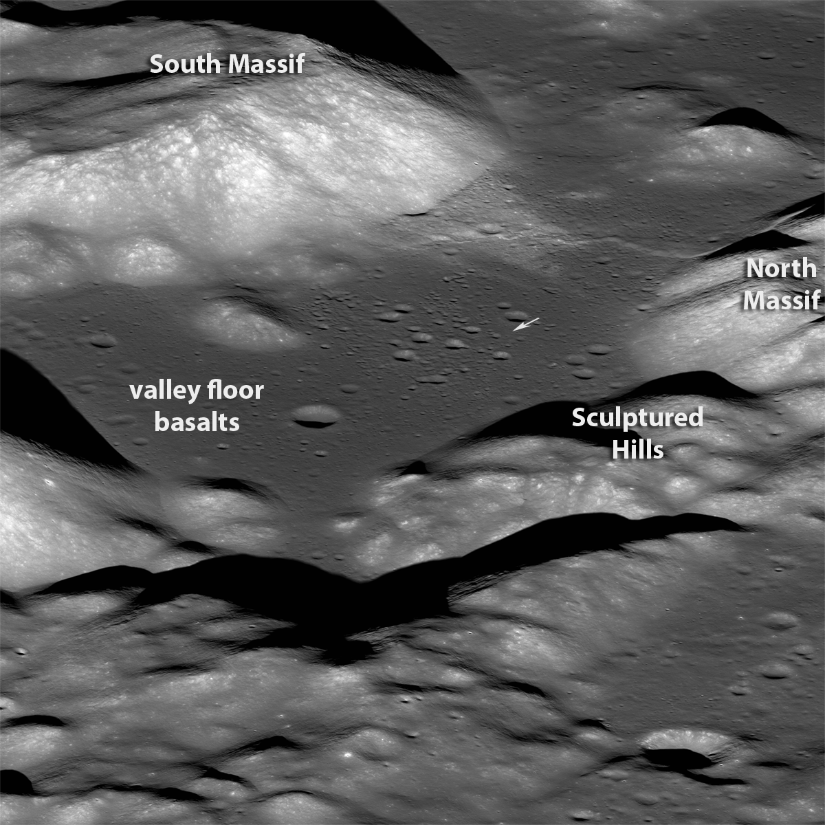
Oblique view of Taurus Littrow, from the West

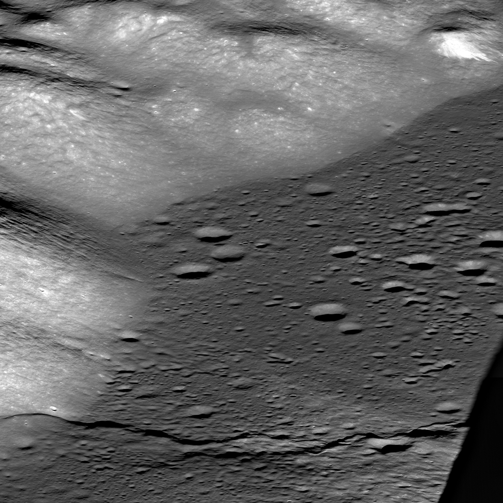
The magnificent Taurus Littrow valley photographed obliquely, from a point 330 km west by northwest, 131.12 km over central Mare Serenitatis, by the LROC Narrow Angle Camera (NAC). The Apollo 17 crew briefly explored this valley 40 years ago this month. LROC NAC observation M1096343661LR, a field of view roughly 10 km across the center; LRO orbit 13936, July 7, 2012 [NASA/GSFC/Arizona State University].
Mark Robinson
Principal Investigator
Lunar Reconnaissance Orbiter Camera
Arizona State University


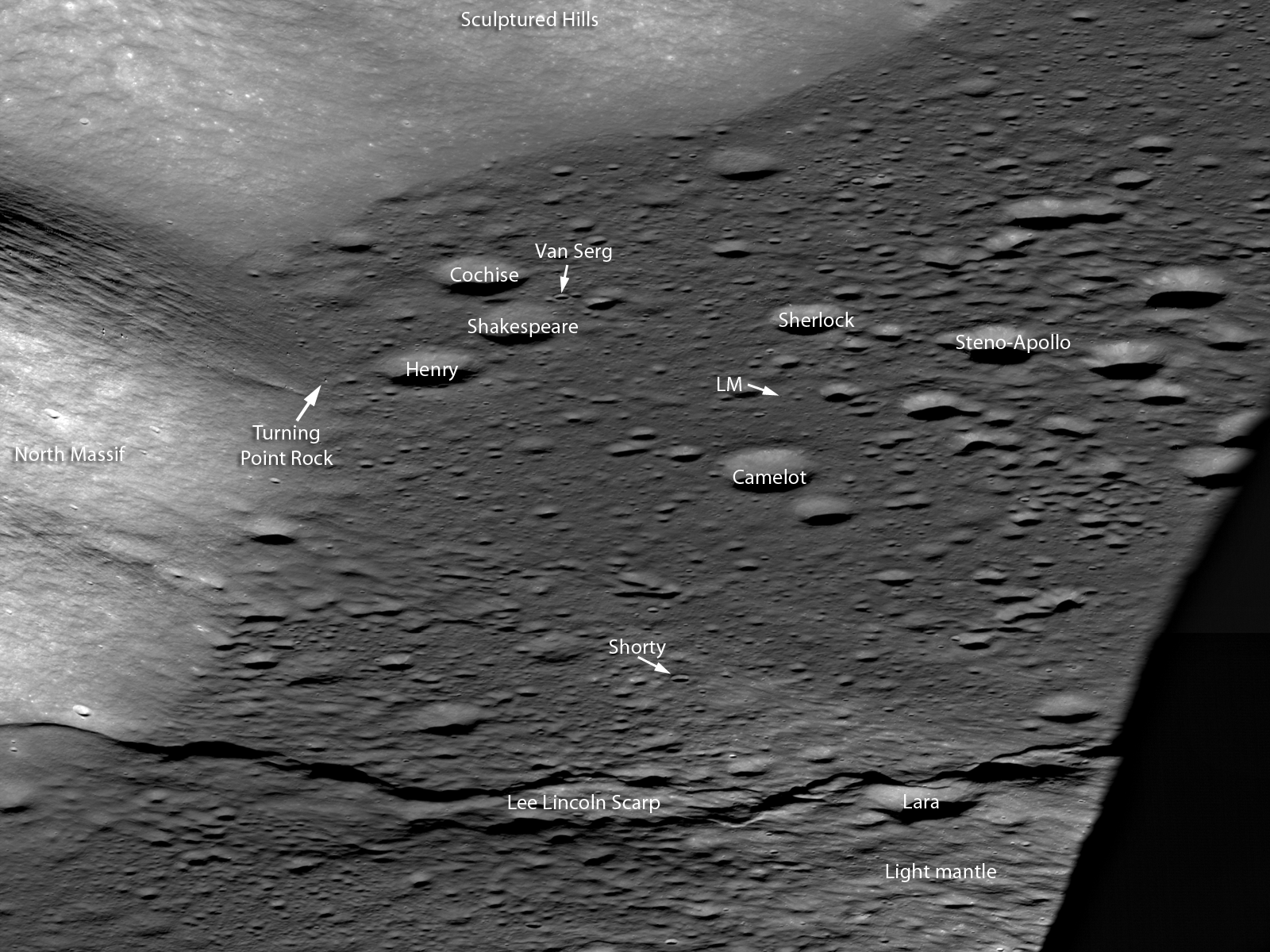
In the lower right, South Massif casts a long evening shadow across the mare basalt flooded Taurus Littrow valley. Note the sharp boundary of the flat mare against the slopes of the Sculptured Hills in the background, similar to a lake shoreline, revealing the very fluid nature of the lava when it filled the valley. Your eye is drawn to the sharp line snaking across the bottom of the image. Note how this ridge traverses across the valley floor and up onto the lower slopes of North Massif (lower left). Astonishingly this feature is a large, young fault: imagine the ground in the foreground being pushed to the east and the crust buckling, a whole section was pushed up and onto the back side of the fault (low angle thrust fault). This step in the valley floor was the result of large scale contractional forces pushing the crust together. The landform created by this type of thrust fault is called a lobate scarp, this one is named the Lee Lincoln scarp. The Lee Lincoln scarp has the distinction of being the first and only extraterrestrial fault to be explored by humans. Astronauts Harrison Schmitt and Gene Cernan actually drove the Lunar Roving Vehicle (LRV) up and over this ridge during their three day exploration of the valley.

Apollo 17 commander Gene Cernan works next to the LRV at Station 3, near Lara crater, (see labeled detail below). AS17-138-21168 [NASA/Harrison Schmitt].
Where the Lee Lincoln scarp stretches into the highlands of North Massif, it abruptly changes directions and extends along slope far beyond the Apollo 17 landing site (black arrows on full NAC image).  The Lee Lincoln scarp is one of a number of such tectonic landforms that were only found in the high resolution Apollo Panoramic Camera images that covered part of the lunar equatorial zone. In LROC NAC high resolution images, lobate scarps have been discovered across the Moon at all latitudes (Watters and coworkers, 2010). The pristine appearance of the lobate scarps and the fact that the features cut across young, small-diameter craters are evidence that the scarps formed recently, more recently than the young craters they deform. The globally distributed population of lobate scarps is an indication that contractional forces are acting on the lunar crust as a result of slow cooling and shrinking of the still hot interior of the Moon.

West to east Oblique labeled - Central portion LROC NAC oblique showing significant features visited by the Apollo 17 crew, LM is the Lunar Module. North is to the left, and south is to the right. The distance along Lee Lincoln scarp from the shadow to North Massif is 8 km, M1096343661LR [NASA/GSFC/Arizona State University].
It was forty years ago today that the Apollo 17 crew splashed down in the Pacific Ocean, ending our first period of human exploration of the Moon. The extensive measurements beamed back from LRO every day are setting the stage for the next era in robotic and human exploration of the Moon. Where would you go on the Moon to continue the work of the Apollo crews?

Trace the Lee Lincoln scarp, HERE, as it snakes its way northward, well away from the Taurus Littrow valley (VSC Van Serg Crater, SC Shorty Crater, LM Lunar Module).

Previous Apollo 17 Featured Images:
Approach To Taurus Littrow Valley (December 12, 2012)
Apollo 17 lands, ending the Apollo era, 40 years ago (December 11, 2012)
The last manned launch to the Moon (December 7, 2011)
Taurus Littrow Oblique (September 29, 2012)
Question Answered! (July 17, 2012)
Significant change in bombardment timing (January 6. 2012)
Just another crater? (December 13, 2011)
Skimming the Moon (September 6, 2011)

Exploring the Apollo 17 Site (October 28, 2009)

Wednesday, December 12, 2012

Approach to Taurus Littrow Valley

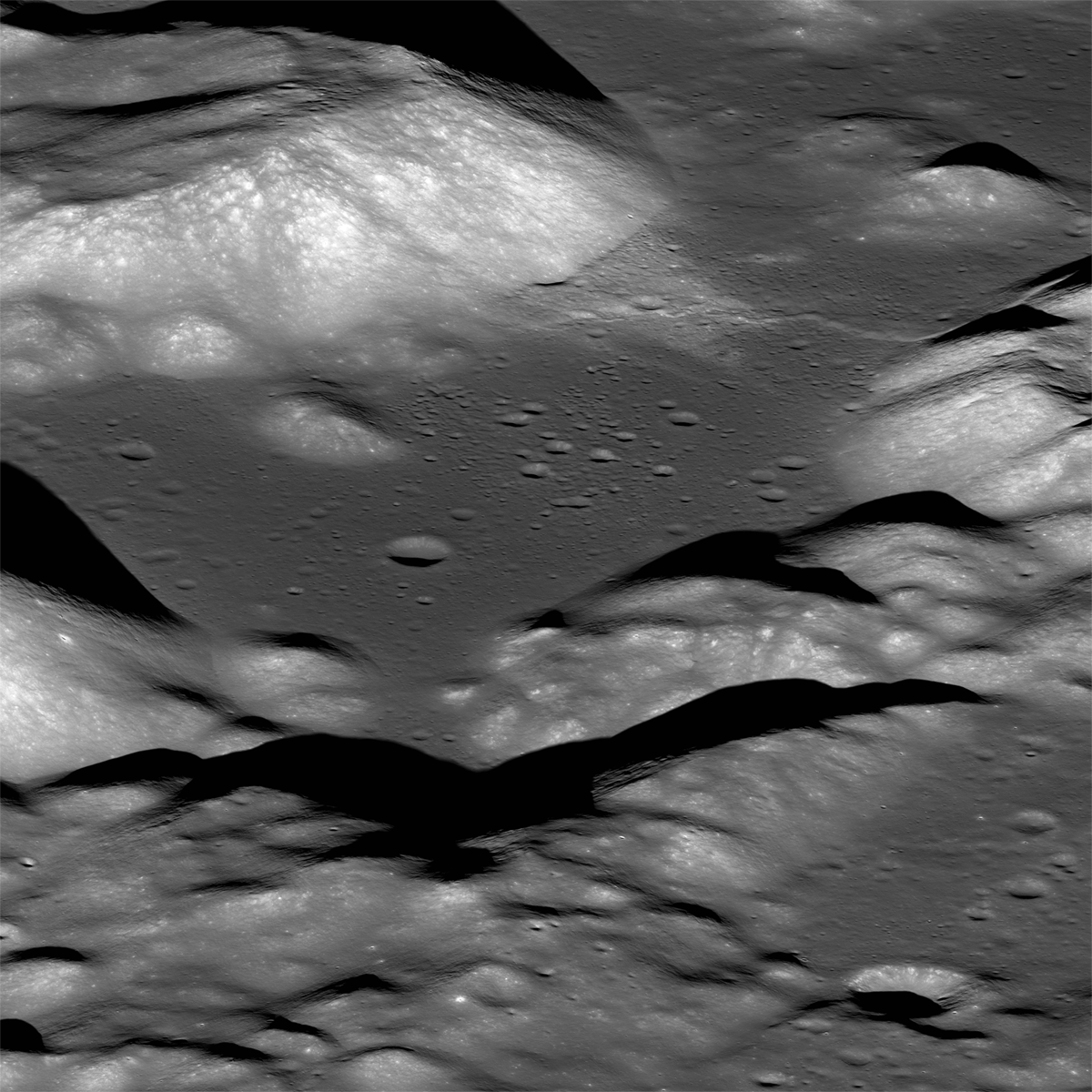
Taurus Littrow Valley from the east. View similar to what the Apollo 17 astronauts saw as they approached their landing in the magnificent Taurus Littrow Valley. (See "Taurus Littrow Oblique," September 29, 2012) LROC Narrow Angle Camera (NAC) east-to-west oblique image pair, about 18 km wide field of view at center, M192703697LR, LRO orbit 13427, May 26, 2012; spacecraft (and camera) slewed 56.09° west from nadir, native resolution 2.79 meters, from 131.29 km over 20.01°N, 38.78°E [NASA/GSFC/Arizona State University]. [NASA/GSFC/Arizona State University].
Mark Robinson
Principal Investigator
Lunar Reconnaissance Orbiter Camera (LROC)
Arizona State University


The Apollo 17 astronauts landed in the Taurus Littrow Valley forty years ago today. One of their key science goals was to collect impact melt from the Serenitatis basin rim so an age date for this important basin could be established. Before the samples were returned most lunar geologists believed this basin to be relatively old amongst all lunar basins. When the age dates came in from the Apollo 17 highland impact melt samples it appeared that the Serenitatis basin was younger than previously thought (3.86 billion years), nearly the same age as the mighty Imbrium basin (young in terms of lunar basins!). Jack Schmitt and Gene Cernan sampled rocks from South and North Massifs and the Sculptured Hills, all three thought to be formed as part of the Serenitatis basin impact event.


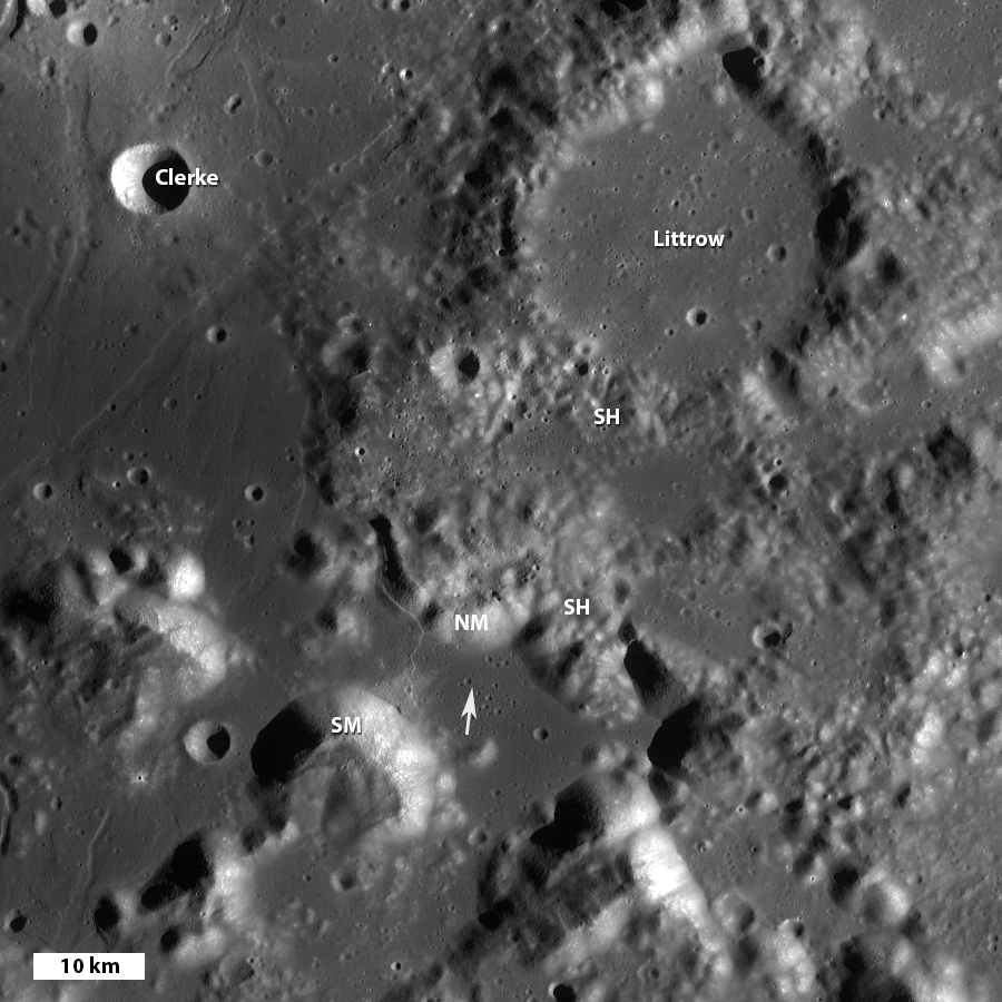
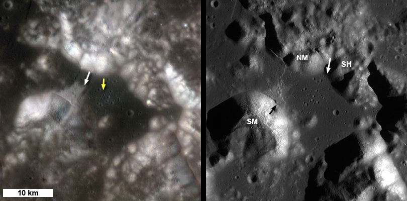
Taurus Littrow valley to Taurus crater, the upper left corner (NW) is the eastern edge of the mare flooded Serenitatis basin. LROC Wide Angle Camera (WAC) mosaic: SM = South Massiff, NM = North Massif, SH = Sculptured Hills, arrow indicates Apollo 17 landing site, north is up, image field of view is 90 km wide [NASA/GSFC/Arizona State University].

The wisdom at the time was that the old relative age assignment of the Serenitatis basin derived from remotely sensed image data must be wrong. Perhaps the confidence of that interpretation was undermined by the relatively poor resolution of the then-existing orbital image data for much of the eastern portion of the nearside of the Moon.

The new WAC global mosaic and NAC high resolution views are allowing scientists to reevaluate many previously held ideas with much clearer data. A new look at the area around the Serenitatis basin using the geologic rule of superposition (Spudis and coworkers, 2011) with LROC images resulted in a confident determination that the Sculptured Hills are actually far flung ejecta from the Imbrium basin, and not Serenitatis basin material. In the WAC mosaic above you can see the hummocky Sculptured Hills formation on top of Taurus crater. Taurus crater in turn was formed on the rim of Serenitatis basin. Thus the Sculptured Hills formed after the Serenitatis basin formed, likely as ejecta from the Imbrium basin impact event.

Annotated version of the LROC Featured Image of Taurus Littrow valley, in a field of view about 18 km wide in center, small arrow indicates landing site, M192703697LR [NASA/GSFC/Arizona State University].
What does this new finding mean? First, if the Sculptured Hills are really Imbrium ejecta it is possible (or even likely) that the Apollo 17 impact melts do not represent the formation age of the Serenitatis basin, but rather that of the Imbrium basin. If so, the evidence that there was a late cataclysm (a big short spike in impact events) just got a lot weaker. On the other hand, if those impact melts do indeed come form the Serenitatis formation event, the fact that Serenitatis is relatively old amongst lunar basins means the late cataclysm was even more compressed than previously thought! In fact, it would suggest that 13-25 of the larger basins all formed within a short period of 50 million years (short in geologic time). Either way, the new determination of the relative age of the Serenitatis basin results in a radical new evaluation of the sequence of events early in lunar history!

Apollo 17 CM above Taurus Littrow - Hasselblad frame shuttered from the LM Challenger as it passed over the Taurus Littrow Valley, note the command module America just visible in front of South Massif in the middle ground, from AS17-147-22464 [NASA].
Reflecting back on the fortieth anniversary of the last human landing on the Moon, and the new results of LRO and other recent missions, we can see that the Apollo landings were a fantastic start to our exploration of the Moon. Many questions were answered from data and samples collected during the Apollo era. Since then, many new discoveries about the Moon have arrived, and more key science questions have appeared. The work begun by Schmitt and Cernan is now being extended by LRO in preparation for the next generation of lunar explorers. With the LROC data we can now map out the best places to search for outcrops of Serenitatis rock (especially impact melt) and obtain a confident age date for this key basin, which in turn places many of the other the other large basins in their proper absolute age.

Here we have seen one example of how new observations are overturning previously held lunar ideas; there are many more examples! It is certainly an exciting time in lunar science as we more forward in this new era of lunar exploration and pave the way for a future human return to the Moon and then beyond.

Zoom in and examine the full resolution NAC oblique perspective of Taurus Littrow, and find key stratigraphic relations, HERE.

Download the Spudis et al (2012), HERE.

Previous LROC Apollo 17 Featured Images
Shorty Crater
Skimming the Moon
Exploring the Apollo 17 Site

Recent Posts:
Apollo 17 lands, ending the Apollo era, 40 years ago (December 11, 2012)
The last manned launch to the Moon (December 7, 2011)
Taurus Littrow Oblique (September 29, 2012)
Significant change in bombardment timing (January 6. 2012)
Just another crater? (December 13, 2011)

Tuesday, December 11, 2012

Apollo 17 lands, ending the Apollo era, 40 years ago

Taurus Littrow valley, from an oblique LRO Narrow Angle Camera perspective, a highly reduced original mosaic of the left and right frames of LROC NAC observation M192703697L. On December 11, 1972, Gene Cernan and Jack Schmitt descended in the Apollo 17 lunar module, with the terrain at their backs, waiting for the spacecraft to tip forward. Only then could they see the valley rushing up below. For a more detailed view of this spectacular oblique observation from LRO, see Taurus Littrow Oblique, Sept. 29, 2012 [NASA/GSFC/Arizona State University]..

A closer, strikingly similar perspective from the Apollo 17 lunar module Challenger during its their final orbital pass over Taurus Littrow before descent and landing. Ron Evans, now alone, pilots the Command Service Module (CSM) America (center). See the much larger original image HERE (AS17-147-22465) [NASA/JSC].
Post landing pan from Jack Schmitt's window, a picture of a landscape untouched except by the descent stage moments before, later assembled into a high-resolution mosaic by Eric Jones for the Apollo Lunar Surface Journal. View the original version of frames AS17-147-22469 through 22476 at ALSJ, HERE.
Near Station 6 on their third (and final) EVA, Schmidt put Challenger in some perspective, capturing this black and white image through a 500 mm lens from over 3 kilometers away. Though spacecraft since the Apollo era managed to resolve the patch of the surface disturbed by the thrust of the descent stage, the LRO alone was equipped and designed to photograph great detail of the Apollo landing sites from orbit since 2009 [NASA/JSC/ALSJ].
Related Posts:
Jack Schmitt holds fast to lunar vision (November 18, 2012)
Taurus Littrow Oblique (September 29, 2012)
LRO LAMP sharpens Apollo surface helium data (July 17, 2012)
Toxicity of Lunar Dust (July 2, 2012)
39 Years (and counting) (December 14, 2011)
Just another crater? (December 13, 2011)
Apollo metric camera maps completed (November 21, 2011)
Cernan says China will be first back to the Moon (November 8, 2011)
Cernan saw peace on Earth (March 14, 2011)
Too brief an expedition to a lobate scarp (August 24, 2010)
Moon geologically active, cooling and shrinking (August 19, 2010)
Graphite found in Apollo 17 samples (July 5, 2010)
Return to Moon, Schmitt says, important for protection of liberty (June 17, 2010)
Water found in Apollo samples (March 10, 2010)
Dr. Jack Schmitt salutes LROC's Mark Robinson and the LRO
camera team at Arizona State
(November 10, 2009)
Apollo 17 from 50 kilometers (October 28, 2009)

Iconic picture (AS17-134-20384) of Apollo 17 lunar module pilot and geologist Harrison Schmitt, by Gene Cernan, soon after the beginning of their first EVA, December 11, 1972. Click on image for high resolution view [NASA/ASJ].
"O Say Can You See," The sixth U.S. flag is "still there," confirmed by a distinctive shadow, north of the Apollo 17 landing site, in one of many exceptional LROC high-resolution Narrow Angle Camera (NAC) studies of the Apollo landing sites, and at Taurus Littrow, where the last Apollo crew began their surface expedition 40 years ago, December 11. LROC NAC M165000580R, LRO orbit 9892, August 14, 2011; resolution 42 cm per pixel from 24.74 kilometers LROC Featured Sites [NASA/GSFC/Arizona State University].

Wednesday, December 14, 2011

39 Years (and counting)

December 14, 1972. Geologist Dr. Harrison "Jack" Schmitt, the only professional scientist to visit another planet, swaps poses with Apollo 17 commander Capt. Gene Cernan following completion of their third and final EVA, exploring Taurus Littrow. It was the last Apollo moonwalk and the end of a breathtakingly successful sixth manned expedition to the lunar surface. When humans may resume this sorely needed activity is no more certain now than it was when, with little ceremony, Cernan climbed back into Challenger to prepare for lift-off. They were ahead of their time, they made it look easy, and the success of such a program at such a time arose from determined political will that was a product of events both wonderful and tragic. But regardless how history coldly credits events, unique and common, for Apollo, today we are without excuse. There is no retreat from tomorrow, and it's long past time to resume this inevitable enterprise, if only for the simple reason that our understanding of our Earth will never be complete without a proper exploration of Earth's Moon, our "deep water access" to the truly endless sea beyond [NASA/ASJ/].

Tuesday, December 13, 2011

Just another crater?

Not ordinary - amazing! A fresh look at Shorty Crater in Taurus Littrow Valley. What makes this 110 meter diameter crater stand out from the rest? A 225 meter-wide section from LROC Narrow Angle Camera (NAC) observation M175077349L, swept-up during LRO's brief very low orbital maneuvers this fall. LRO orbit 10935, November 11, 2011, 25 centimeters per pixel scale, view the full size LRO image released December 13, 2011, HERE [NASA/GSFC/Arizona State University].
Mark Robinson
Principal Investigator
Lunar Reconnaissance Orbiter Camera
Arizona State University

Shorty crater is an amazing place on the Moon! From orbital photos, Apollo-era scientists identified this small crater as a place worth visiting. Even though the existing images at the time had limited resolution, analysts could see that Shorty crater was surrounded by a dark (low reflectance) field of ejecta. Since the area seemed to be blanketed by pyroclastic (explosive volcanism) materials, the dark ejecta around Shorty crater led scientists to speculate that perhaps this crater was a volcanic vent, and not an impact scar (see the pre-mission USGS geologic map of Taurus-Littrow). It was yet another reason to send an Apollo lander to the valley of Taurus-Littrow.

Two views of the Taurus-Littrow Valley. On the left is a composite of three LROC Wide Angle Camera (WAC) color bands (Red 689 nm, Green 415 nm, Blue 321 nm), and on the right is a sunrise WAC mosaic. Each image covers the same area and is 40 km wide. View the larger LROC context image HERE [NASA/GSFC/Arizona State University].
On 11 December 1972, Apollo 17 landed in the middle of this fascinating valley. The mission goals included sampling rocks and soil that might reveal the age of the distant Tycho crater forming impact, sampling ancient highland material that might reveal the ages of two mighty basins, return another variety of basalt, collect dark pyroclastic material, and see if Shorty crater was indeed a volcanic vent. Shorty crater is found (white arrow, left WAC mosaic) on a tongue of high reflectance material emanating from South Massif (labeled 'SM' on right right mosaic), about 7 km to the west of the Apollo 17 landing site (yellow arrow).

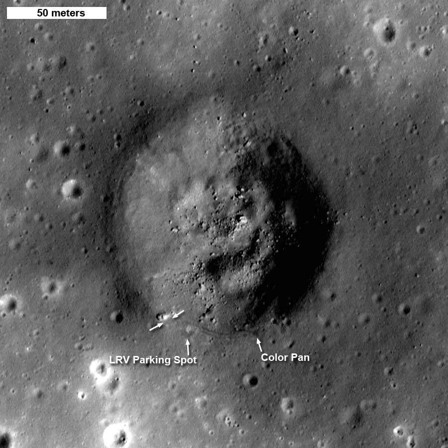
Shorty crater (110 meters diameter), small black arrow points to rock labeled in the Hasselblad camera shot captured by Captain Cernan, shown below. (Annotated, from M175077349L 225 meters wide, north is up. View the full size context image HERE [NASA/GSFC/Arizona State University].
Apollo 17 astronauts Harrison "Jack" Schmitt and Eugene "Gene" Cernan spent three days performing a reconnaissance exploration of part of Taurus-Littrow Valley. On the second day they drove the Lunar Roving Vehicle (LRV) as far as 8.7 km WSW of the Lunar Module (LM), to the edge of Nansen crater, at the foot of South Massif. On the way back to the LM they headed north across Lee Lincoln scarp (a thrust fault), and on to Shorty crater. It was at the edge of Shorty crater where Schmitt first noticed orange soil underfoot! At the moment it seemed that the crew had indeed discovered oxidized rock, a sure sign of fumarolic volcanic vent.

One frame of the 360° panorama sequence obtained by Gene Cernan some 40 meters east of the orange glass sampling site. Harrison Schmitt is seen by the parked LRV. Box highlights orange soil on the steep wall of the crater, black arrow points out rock also arrowed on the NAC view above. Apollo 17 Hasselblad AS17-137-21009 [NASA].
Harrison Schmitt, a life-long geologist, is still very active in the planetary science community and wrote a few thoughts upon seeing the new NAC image of Shorty crater.

Jack Schmitt's trench, and the orange soil found at Shorty crater, Apollo 17 Lunar Surface Journal. AS17-137-20990 [NASA].

"The location of the one-wall trench I dug across the crater rim to get samples of the orange glass and the black partially crystallized glass beneath it. I dug the trench wall so it faced the sun to provide good photographic images. Using the sampling scoop I normally carried, I threw the trench debris so that it all went away from the boulder. Being orange rather than gray, the debris is slightly lighter than the surrounding surface debris (regolith), and is visible as a spray pattern in the image."

"Shorty Crater is about 14 m deep. Based on our investigations at the site and later examination of photographs, the impact that formed it penetrated, in order, regolith on the avalanche deposit, the avalanche deposit, regolith on a basalt flow, a basalt flow overlying and protecting the orange and black glass layers, the orange and black glass layers, regolith on a second basalt flow, and, finally, the upper portion of that second flow. Orange and black glass clods and basalt boulders are spread throughout the ejecta blanket surrounding Shorty."  -Harrison H. Schmitt, Lunar Module Pilot and Geologist, Apollo 17

You can see the orange soil that Schmitt sampled in the surface photo shown above, note also the streamer of orange glass extending down the the steep inner wall of the crater (indicated with black box). To help orient yourself in the surface image, imagine yourself  standing on the spot marked 'Color Pan' in the NAC image, that is the viewpoint from where Gene captured his 360° panorama series of photographs. If you look closely in the NAC image, you can trace Cernan's tracks from the area of the trench that Schmitt dug, and then back to the rover (two darker parallel lines).

As it turns out the orange soil was not oxidized vent material, but something equally exciting -- titanium-rich pyroclastic glass! When the Shorty impact event occurred, the pyroclastic glass was excavated from about 10 meters below the surface and thrown out onto the rim. Talk about a case of lucky timing! The orange glass was deposited several billion years ago, then shortly after it was deposited, a thin layer of basalt flooded this portion of the valley and formed a protective cap. Then, not too long ago, the orange glass was brought to the surface and the Apollo 17 crew arrived. Eventually the Shorty crater deposits will get churned back into the surrounding landscape by small impacts: Schmitt and Cernan came by at just the right time.

What did we learn from the orange and black soil? These key samples showed that the idea that the valley had witnessed very large fire fountaining eruptions was correct. Imagine lava being erupted so fast that it shot up many hundreds of meters, and splashed over the terrain for many tens of kilometers. Why so high? Because there were large amounts of gases in the magma that rapidly exsolved as it neared the surface. A process similar to what you experience upon shaking a soda can and opening it up -- spray! Scientists were able to find minute remnants of volatiles on the glass beads (both orange and black), including zinc and sulfur. From the extent of the deposit and its composition, it was clear that these materials came from deep sources within the mantle. So by simply walking to the edge of this small, seemingly insignificant, crater the crew were able to sample and bring back incredibly valuable samples of the deep Moon.

That is not the end of the story, the next day Cernan and Schmitt drove north and then east to sample the North massif (NM) and the Sculptured hills (SH). Both destinations were older than the mare, they represented two different ancient crustal samples. From these rocks scientists were able to determine absolute age dates for the formation of an ancient basin. All-in-all Apollo 17 was a smashing success for both science and engineering.

Read more about the geology of Taurus-Littrow valley in the definitive USGS report, and examine Shorty crater and its environs in detail.

Thirty-nine years have passed since humans last walked on the Moon. When will we return?

Tuesday, March 15, 2011

Cernan saw peace on Earth


Apollo 17 commander Gene Cernan, back in the Lunar Module Challenger, is photographed by LM pilot Harrison Schmitt completing a total 22 hours, 6 minutes, 45 seconds on the lunar surface at the end of EVA-3, December 14, 1972 [NASA/ALSJ].

Michael Shinabery
New Mexico Museum of Space History
Alamogordo Daily News


During early spaceflights, little things alleviated big frustrations.

"We had to take some chewing gum, Dentyne chewing gum, on Gemini IX, just to keep our mouth refreshed," Gene Cernan said in a 2007 NASA oral history. "We couldn't take toothpaste and toothbrushes, because what are you going to do with the toothpaste? Well, we're going to swallow it. Oh, you can't swallow it."

Cernan, born on March 14, 1934, made three spaceflights, his final one as Apollo 17 commander. Before climbing into the lunar module Challenger, he left man's last footprints on the Moon.

"We leave as we came and, God willing, we shall return with peace and hope for all mankind," The Associated Press reported Cernan said.

"I never even thought about (my words) until I was crawling up, basically crawling up the ladder," Cernan said in the Dec. 11, 2007 oral history, on the 35th anniversary of his lunar landing.

Cernan was at Purdue University when he "received his commission through the Navy ROTC Program," the website jsc.nasa.gov said. In October 1963 NASA chose him among 14 astronauts. In 1966 he piloted Gemini IX, becoming "the second American to walk in space"; he was outside the capsule for two hours and 10 minutes. Subsequently, he was "backup pilot for Gemini 12 and ... backup lunar module pilot for Apollo 7," and later " backup spacecraft commander for Apollo 14."

Cernan's second flight was in May 1969, as Apollo 10 LM pilot. He descended "to within (eight) nautical miles of the lunar surface," jsc.nasa.gov said, "demonstrating that man could navigate safely and accurately in the moon's gravitational fields."


Taurus-Littrow Valley, skirting the eastern shore of Mare Serenitatis, the landing site of Apollo 17 as seen from the general but simulated perspective along a line-of-sight view from Earth. The pitch-over before landing took place over the mountainous terrain on the Valley's eastern side. LROC Wide Angle Camera monochrome mosaic centered at 0 degrees longitude (the lunar nearside) [NASA/GSFC/Arizona State University].

Apollo 17 launched on December 7, 1972, "the first manned nighttime launch," said jsc.nasa.gov. Four days later, Cernan and Harrison Schmitt touched down at Taurus-Littrow.

He "waited a long time for December 11, 1972 to come around," Cernan said. "I'm flying. A lot of people think we pressed a button and let the thing fly itself. There's no way I'm going to go all the way to the Moon and let a computer land me on the Moon. The arrogance of a pilot, particularly naval aviators, is too great to allow that to happen. Nobody ever landed on the Moon other than with their own two hands and brain and eyeballs."

Read the article HERE.