Tuesday, December 11, 2012

Apollo 17 lands, ending the Apollo era, 40 years ago

Taurus Littrow valley, from an oblique LRO Narrow Angle Camera perspective, a highly reduced original mosaic of the left and right frames of LROC NAC observation M192703697L. On December 11, 1972, Gene Cernan and Jack Schmitt descended in the Apollo 17 lunar module, with the terrain at their backs, waiting for the spacecraft to tip forward. Only then could they see the valley rushing up below. For a more detailed view of this spectacular oblique observation from LRO, see Taurus Littrow Oblique, Sept. 29, 2012 [NASA/GSFC/Arizona State University]..

A closer, strikingly similar perspective from the Apollo 17 lunar module Challenger during its their final orbital pass over Taurus Littrow before descent and landing. Ron Evans, now alone, pilots the Command Service Module (CSM) America (center). See the much larger original image HERE (AS17-147-22465) [NASA/JSC].
Post landing pan from Jack Schmitt's window, a picture of a landscape untouched except by the descent stage moments before, later assembled into a high-resolution mosaic by Eric Jones for the Apollo Lunar Surface Journal. View the original version of frames AS17-147-22469 through 22476 at ALSJ, HERE.
Near Station 6 on their third (and final) EVA, Schmidt put Challenger in some perspective, capturing this black and white image through a 500 mm lens from over 3 kilometers away. Though spacecraft since the Apollo era managed to resolve the patch of the surface disturbed by the thrust of the descent stage, the LRO alone was equipped and designed to photograph great detail of the Apollo landing sites from orbit since 2009 [NASA/JSC/ALSJ].
Related Posts:
Jack Schmitt holds fast to lunar vision (November 18, 2012)
Taurus Littrow Oblique (September 29, 2012)
LRO LAMP sharpens Apollo surface helium data (July 17, 2012)
Toxicity of Lunar Dust (July 2, 2012)
39 Years (and counting) (December 14, 2011)
Just another crater? (December 13, 2011)
Apollo metric camera maps completed (November 21, 2011)
Cernan says China will be first back to the Moon (November 8, 2011)
Cernan saw peace on Earth (March 14, 2011)
Too brief an expedition to a lobate scarp (August 24, 2010)
Moon geologically active, cooling and shrinking (August 19, 2010)
Graphite found in Apollo 17 samples (July 5, 2010)
Return to Moon, Schmitt says, important for protection of liberty (June 17, 2010)
Water found in Apollo samples (March 10, 2010)
Dr. Jack Schmitt salutes LROC's Mark Robinson and the LRO
camera team at Arizona State
(November 10, 2009)
Apollo 17 from 50 kilometers (October 28, 2009)

Iconic picture (AS17-134-20384) of Apollo 17 lunar module pilot and geologist Harrison Schmitt, by Gene Cernan, soon after the beginning of their first EVA, December 11, 1972. Click on image for high resolution view [NASA/ASJ].
"O Say Can You See," The sixth U.S. flag is "still there," confirmed by a distinctive shadow, north of the Apollo 17 landing site, in one of many exceptional LROC high-resolution Narrow Angle Camera (NAC) studies of the Apollo landing sites, and at Taurus Littrow, where the last Apollo crew began their surface expedition 40 years ago, December 11. LROC NAC M165000580R, LRO orbit 9892, August 14, 2011; resolution 42 cm per pixel from 24.74 kilometers LROC Featured Sites [NASA/GSFC/Arizona State University].

The Sweeping Shadow, Australia, November 14


The Sweeping Shadow - Total Solar Eclipse, Nov 14 2012,The Granite, FNQ, Australia. from Colin Legg on Vimeo.

I was fortunate to view the eclipse from "The Granite' in far north Queensland this November. Inspired by Joe Cali's short but spectacular footage of the 2008 event (https://vimeo.com/51646602), I sought a high vantage point to capture the sweep of the shadow. Clear views north and east proved difficult to find, so I had to hike an 850m peak the night before and sleep on a rock ledge.

The clip includes 3 timelapses at various focal lengths. The first used a constant exposure, while the latter 2 tracked the light in the final 2 minutes either side of C2/C3, using bulb scripting. Eclipse Orchestrator software managed the light curve, while the cameras were triggered by a custom microcontroller built by Thomas Bethel. Many thanks to Fred Bruenjes and Thomas Bethel.

You can find out more about my eclipse experience here: https://www.facebook.com/ColinLeggPhotography

- Colin Legg
Astronomy Picture of the Day
December 10, 2012

Another incredible demonstration of the apex foci of the Moon's umbra shadow, subtending a cone 1700 km-wide at the lunar limb, stretching 362,000 km and arriving at a point miraculously near the surface of Earth, where it is barely 80 km across.

The surface of the Moon: What lies beneath?

The Moon's anisotropic composition is well represented in this Mercator projection of lunar gravity, mapped at unprecedented resolution by the twin GRAIL lunar orbiters and centered on the Moon's farside [NASA/JPL/MIT].
Paul D. Spudis
Smithsonian Air & Space

The NASA mission GRAIL (Gravity Recovery And Interior Laboratory) has been orbiting the Moon since last spring.  The mission consists of two identical small spacecraft (dubbed Ebb and Flow) that very carefully keep track of their relative position from each other.  By tracking both of these spacecraft with high precision from Earth, we can monitor any small variations (caused by variations in the Moon’s gravity field) away from their predicted orbital paths.  If the satellite is flying over an area on the Moon with less material than normal (for example, over a deep crater, a hole in the Moon’s crust), it will be less attracted to the Moon because of this mass deficiency and will therefore fly away from the Moon.  If, on the other hand, it flies over an area of excess mass, such as a thick stack of dense lava flows, the excess mass pulls the satellite slightly toward it, increasing its speed and pulling it downwards.  As Ebb and Flow orbit the Moon, they conduct a delicate “dance.”  These movements are caused by variations in the Moon’s gravity (largely a reflection of variations in the density of its crustal rocks).  When combined with the high-resolution, precision topography of the Moon (currently being gathered by the Lunar Reconnaissance Orbiter), we are able to reconstruct the structure and thickness of the lunar crust from orbit.

GRAIL has unveiled a new global gravity data set, very high in resolution and precision and greater than ten times better than our previous version of the global gravity from the Japanese mission SELENE (Kaguya).  One interesting result shows unusual structure – long, quasi-linear gravity features appear in a variety of locations associated with lunar impact basins.  Basins are very large craters that formed during asteroid collisions prior to 3.8 billion years ago.  Some of these linear features extend on great circles across the lunar globe for distances of more than 500 km. These results suggest that solidified intrusions of once-molten rock may form a dense, criss-crossing network within the upper crust.

In order to understand the significance of these gravity features, it is necessary to understand some elementary facts about planetary geology.  Planets generate heat and this heat must be dissipated.  Typically, the heat generated from both the original energy release during formation (accretion) and from the decay of radioactive elements (e.g., uranium) melts the interiors of planets, forming bodies of liquid rock called magma.  This magma is usually less dense than the rocks from which it forms and thus, rises upwards towards the surface.  Sometimes, the molten rock cannot ascend any higher from the deep locations where it comes from and freezes in place – geologists call this type of frozen rock body an intrusion, because it intrudes into pre-existing rock as a liquid and then solidifies by crystallizing.  When magma actually reaches the surface of a planet, it can erupt onto its surface as lava; this activity is called extrusive because the molten rock extrudes onto the surface and then solidifies as lava flows.

Clearly, all erupting lava must have at one time been an intrusive magma body, at least during the time it was ascending upwards toward the surface.  Although many magma bodies reach the surface and create lava flows (such as the dark, smooth maria of the lunar lowlands), sometimes this magma cannot reach the surface and freezes in place within the crust as a linear or tabular body.  Such features (called dikes) are an essential part of the underground, igneous plumbing of volcanoes on all of the terrestrial planets.  We knew that they must have formed on the Moon because we saw the evidence of vents and structures in the maria that are the surface expression of such features.

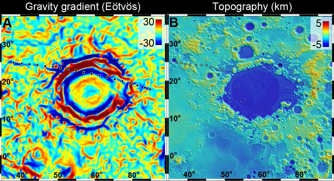
For the first time, the new GRAIL data show us direct evidence for these buried igneous dikes within the lunar crust.  One particularly prominent dike occurs near the Crisium basin, on the eastern near side of the Moon.  This dike extends over 1000 km in a quasi-radial direction northwest of the Crisium rim, disappearing beneath the mare lavas of that basin.  The fact that it is not clearly aligned with the basin structure suggests that it may predate it; we estimate that Crisium basin is older than 3.9 billion years.

Newly released GRAIL lunar gravity gradient map centered on Mare Crisium. An otherwise essentially invisible 300 km-long density of mass was detected buried under 3.9 billion year old Crisium (dotted line) [NASA/JPL/MIT].
Small scale topography of the Crisium basin, assembled from laser data points collected by the LOLA instrument aboard the Lunar Reconnaissance Orbiter [NASA/GSFC].
Mare Crisium and vicinity in a monochrome 1240 km-wide field of view from the LROC Wide Angle Camera 100 meter resolution global mosaic [NASA/GSFC/Arizona State University].
This long linear feature may have been formed when molten magma from the deep interior of the Moon oozed its way toward the surface, before “freezing” at some intermediate level.  Its presence, evident now only by a faint gravity signature (those denser areas “tugging” on the GRAIL satellites “Ebb” and “Flow”), is a tell-tale remnant of its existence deep inside the Moon’s crust.

The highly-detailed GRAIL lunar gravity gradient orthographic map, centered near 60° E meridian (and Mare Crisium, above center). The third of the hemisphere at right is on the Moon's farside. To view the spectacular new animations at their highest-available resolution by visiting the Science Visualization Studio (SVS) at NASA Goddard Space Flight Center, HERE [NASA/JPL/MIT/GSFC/SVS].
Many other linear and circular features are evident in the gravity gradient map produced by GRAIL.  Most of these seem to be associated with the large basins of the lunar highlands, the largest impact craters on the Moon. These features both excavate large amounts of crustal material during formation, and serve as topographic lows and structural traps for the accumulation of subsequent erupted lavas.  The gradient structures show a complex network of density patterns in the shallow subsurface of the Moon; this area is a morass of crushed rock, fractures, large faults and collapse features.  The entire outer portion of the lunar crust has been shattered and broken by an impact barrage of almost unimaginable violence.  The crust has since been partly annealed together by heat, re-fractured by additional impacts, intruded by large bodies of molten rock, resurfaced by the eruption of lavas from the deep interior, and finally has had its outermost surface pulverized into a fine powder by the micrometeorite bombardment.

The Moon may look like a silent, dead world but its past (which is Earth’s past) is testament to an early history of extreme violence and chaos.  The results from the GRAIL mission are helping us understand this complex story.

Originally published at his Smithsonian Air & Space blog The Once and Future Moon, Dr. Spudis is a senior staff scientist at the Lunar and Planetary Institute. The opinions expressed are those of the author and are better informed than average.

Turning science fiction to science fact: Golden Spike makes plans for human lunar missions

Golden Spike proposes to land humans on the surface of the Moon commercially as soon as 2020, for a price tag that has raised eyebrows—and some skepticism [Golden Spike Company].
Jeff Foust
The Space Review

The last 12 months has seen the unveiling of a number of commercial space ventures whose audacious plans can’t be immediately dismissed given the technical and financial pedigree of their founders and backers. Almost exactly a year ago, Microsoft co-founder Paul Allen announced the formation of Stratolaunch Systems, an air-launch system that requires the development of the world’s largest airplane. Allen assembled a team that included Scaled Composites and, originally, SpaceX (since replaced by Orbital Sciences), with a board that included Burt Rutan and former NASA administrator Mike Griffin (see “Stratolaunch: SpaceShipThree or Space Goose?”, The Space Review, December 19, 2011). In April, Planetary Resources announced plans for a series of robotic missions to prospect and, eventually, mine asteroids. That company has an impressive list of investors, including Google’s Larry Page and Eric Schmidt as well as Ross Perot Jr. and former Microsoft executive and two-time space tourist Charles Simonyi (see “Planetary Resources believes asteroid mining has come of age”, The Space Review, April 30, 2012).

Yet, the goals of these startups—a giant air-launch system and missions to prospect and mine asteroids—pale in comparison to the goal of another new space startup: sending people to the surface of the Moon. That feat has been accomplished only six times, and by one nation, the United States, with the last such mission, Apollo 17, flying 40 years ago this month. At the time, it was a potent symbol of America’s capabilities, and one of the signature achievements of the 20th century. The scale of that accomplishment, in many respects, grows as the decades stretch on without anyone else repeating it.

Given those factors, the idea that a human landing on the Moon could be done commercially, and for a fraction of the cost of Apollo or any more recent proposal, hardly seems credible. However, like those other firms, the plans of Golden Spike, the company that formally announced last week its desire to carry out such missions starting as soon as 2020, can’t be easily dismissed. The company has assembled an impressive team, including an Apollo veteran and others with experience in technology, science, policy, and finance. But can this lunar A-team overcome what are likely to be giant technical and financial obstacles?

Read the full article at The Space Review, this week, HERE.

Monday, December 10, 2012

Flight training for Apollo: An interview with astronaut Harrison Schmitt

Apollo 17 lunar module pilot (and future U.S. Senator) geologist-astronaut Dr. Harrison "Jack" Schmidt, December 14, 1972, soon after close-out of the the mission's third and final walk on the Moon. This week marks the 40th anniversary of Apollo 17, the last mission to the Moon and the last time manned spaceflight left Earth orbit. AS17-134-20530 [Gene Cernan/NASA].
Jason Catanzariti
The Space Review

Harrison “Jack” Schmitt was selected by NASA as a scientist-astronaut in 1965. Unlike the Space Shuttle era, all astronauts at that time had to qualify as pilots. Trained as a geologist and having never flown an airplane before, he joined a class of cadets for the year-long Undergraduate Pilot Training program at Williams Air Force Base.

The syllabus began with small propeller planes, later moving on to jets, including the supersonic T-38 Talon. Schmitt would have a long relationship with the T-38, as NASA astronauts used them for pilot proficiency and travel. He also received helicopter training that was overseen by the Navy.

Schmitt eventually flew as lunar module pilot on the Apollo 17 mission in December 1972. During the liftoff from the Moon there was a communications problem, and it was his job to solve it. I spoke with Dr. Schmitt about his experiences learning to fly, and how they impacted his actions during his flight to the Moon.

Read the interview, featured this week at The Space Review, HERE.

Saturday, December 8, 2012

GRAIL twins coax out the Moon's deeper history of the solar system's early, pulverizing bombardment

GRAIL primary mission global gravity map, centered on 0°N, 355°E, from animation released Dec. 5, 2012. Science Visualization Studio (SVS), GSFC [NASA/JPL/MIT].
Jennifer Chu
MIT

Beneath its heavily pockmarked surface, the moon’s interior bears remnants of the very early solar system. Unlike Earth, where plate tectonics has essentially erased any trace of the planet’s earliest composition, the moon’s interior has remained relatively undisturbed over billions of years, preserving a record in its rocks of processes that occurred in the solar system’s earliest days.

Now scientists at MIT, NASA, the Jet Propulsion Laboratory and elsewhere have found evidence that, beneath its surface, the moon’s crust is almost completely pulverized. The finding suggests that, in its first billion years, the moon — and probably other planets like Earth — may have endured much more fracturing from massive impacts than previously thought.

The startling observations come from data collected by NASA’s Gravity Recovery and Interior Laboratory (GRAIL) mission. Since March, the mission’s twin spacecraft, named Ebb and Flow, have been orbiting the moon and measuring its gravitational field.

From GRAIL’s measurements, planetary scientists have now stitched together a high-resolution map of the moon’s gravity — a force created by surface structures such as mountains and craters, as well as deeper structures below the surface. The resulting map reveals an interior gravitational field consistent with an incredibly fractured lunar crust.

“It was known that planets were battered by impacts, but nobody had envisioned that the [moon’s] crust was so beaten up,” says MIT’s Maria Zuber, who leads the GRAIL mission and is the E.A. Griswold Professor of Geophysics in the Department of Earth, Atmospheric and Planetary Sciences. “This is a really big surprise, and is going to cause a lot of people to think about what this means for planetary evolution.” 

Zuber and her colleagues detail their findings from GRAIL in three papers published this week in Science.

GRAIL’s lunar gravity map has also revealed numerous structures on the moon’s surface that were unresolved by previous gravity maps of any planet, including volcanic landforms, impact basin rings, and many simple, bowl-shaped craters. From GRAIL’s measurements, scientists have determined that the moon’s crust, ranging in thickness from 34 to 43 kilometers, is much thinner than planetary geologists had previously suspected. The crust beneath some major basins is nearly nonexistent, indicating that early impacts may have excavated the lunar mantle, providing a window into the interior.

Lifting a veil: In addition to mapping the Moon's anisotropic gravity with unprecedented granularity, the GRAIL primary mission uncovered deeper, essentially vertical dyke structures hundreds of kilometers long, the existence of which had been erased at the surface [NASA/JPL/MIT].

To generate the gravity map, GRAIL’s two probes measure the changing distance between themselves as they orbit in tight formation around the moon. As one of the probes flies over a large mass, such as a mountain or dense, underground rock, the stronger local gravity will pull that probe ahead, widening the space between the two spacecraft. Scientists can translate this changing distance into a gravitational map, representing the gravity produced by both the surface structures and the interior.

To find the gravitational field for the moon’s interior alone, Zuber’s team used topographic measurements from another of their instruments, a laser altimeter aboard the Lunar Reconnaissance Orbiter, a separate spacecraft in orbit around the moon. The scientists calculated the gravitational field expected to be produced by the moon’s topography — its surface structures alone — then subtracted that field from the field measured by GRAIL.

“It’s essentially like removing a veil to reveal the gravity due to the inside of the planet,” Zuber says. “And when we saw those maps, we were just speechless.”

The GRAIL primary science mission also succeeded in definitively mapping the thickness of the Moon's outer crust, shown in another global animation centered over the thickest zones on the lunar farside. The South Pole-Aitken basin, oldest and largest identified impact at 4.1 billion years, hosts some of the thinnest outer crust. The mission has increased the likelihood that fragments of the Moon's deeper zones will eventually be found on the surface, excavated by complex craters located on or near the basin's rim [NASA/JPL/MIT].
Compared to the surface, the map of the interior looked extraordinarily smooth. In fact, the team found that most of the moon’s local gravity is due to surface features, such as crater rims and mountains. Except for the large impact basins, the moon’s upper crust, largely lacks dense rock structures, and is instead likely made of porous, pulverized material.

The interior map did reveal long, linear structures of denser material, which Zuber and her team believe to be buried lunar dikes — formed from magma that seeped into large fractures in the crust, and then solidified into dense walls of rock. These dikes represent evidence for expansion of the moon in its earliest history. But overall, 98 percent of the lunar crust is fragmented — a clear remnant of very early, very massive impacts.

“This is interesting for the moon,” Zuber says. “But what it also means is that every other planet was being bombarded like this.” The resulting fractures, she says, affect the way a planetary body loses heat and also provide a pathway for the transport of interior fluids.

David Kring, a senior staff scientist at the Lunar and Planetary Institute in Houston, says knowing the extent of pulverization in the moon’s crust is an essential detail needed to determine the moon’s bulk composition. Such information would go a long way toward identifying the processes the formed the moon and other planets.

“The staggering quality of the data reported by Professor Zuber and her colleagues is amazing,” says Kring, who was not involved in the research. “The data are exciting because they foretell far more insights than are captured in these initial three papers.”
NASA has scheduled a news conference to discuss the planned deorbiting and impact of the GRAIL spacecraft, December 13.


In addition to GRAIL’s discoveries, Zuber says another major accomplishment has been the performance of the spacecraft themselves. To achieve the mission’s science goals, the two probes, which can travel more than 200 kilometers apart, needed to be able to measure changes in the distance between them to within a few tenths of a micron per second. But GRAIL actually outperformed its measurement requirements by about a factor of five, resolving changes in spacecraft distance to several hundredths of a micron per second — one twenty-thousandth the velocity that a snail travels. 

“On this mission, with two spacecraft, everything had to go perfectly twice,” Zuber says, adding proudly: “Imagine you’re a parent raising a twins, and your children sit down at the piano and play a duet perfectly. That’s how it feels.”

Friday, December 7, 2012

The last manned launch to the Moon at 40

0533 UT - 7 December 1972 - Night Launch of Apollo 17 [NASA].
It was a peak experience, absorbed with ponderous wonder, viewed from the roof of a house 300 kilometers away.  It was the first launch of a Saturn V that I did not watch on live TV, between ages ten and fifteen, often because of a father's appreciation for a son's passionate interest. Sitting on that roof, I was worried about missing the that last manned flight to the Moon, the last time anyone would fly on rocket that size.

These were moments bristling with history, and some bitterness in knowing Apollo 17 would be last. And if I'd known at fifteen I would be describing Apollo 17 as the last manned flight to the Moon forty years later, or saddled with even less certainty as to when human exploration of the Moon will resume, I would have made different choices.


We don't get a replay, of course, so I risked missing a televised Apollo launch, and the last, by establishing myself on the roof, together with a good radio. My mother, meanwhile, paced the lawn down below with her attention split between seeing whatever there might be see in the the north shortly after 12:33 am and worrying that I would fall and break my neck.

We did not know precisely what to expect, though everyone within 800 miles of Kennedy Space Center, half way up the coast from South Miami where we were, had been told the launch would be "visible."

Though I had a better than average since of where the Cape was, beyond and under the north horizon, my concern over being disappointed grew as we listened through the countdown and launch and after a long thirty seconds and more passed without anything unusual appearing in the sky.

My eyes went from one floating point of light to another casting over the north horizon, anticipating something as bright, perhaps, as the helicopters and airliners always busy in that direction. 

Then my jaw dropped.

Rising over the hazy glow of a hundred thousand street lights very suddenly appeared an upside down fountain of white fire. Dad came out of the house right about then and asked if we had seen anything. Mom and I both silently pointed north, toward the impossible comet. He became uncharacteristically silent.

The apparition rose ten, then twenty, degrees over the horizon, and I was glad so many houses in South Florida are single-story structures and that the terrain was so flat. We were helped also by December weather, a sky unusually clear.

The rising plume of fire was enormous, a full five degrees long or more, and it was dancing and licking its way into the the sky, bright though it was far away.  It looked like it had must have been launched from Fort Lauderdale, not the Cape, and when staging took place, it ruined every fireworks display I witnessed thereafter.

Easily among the most reproduced of photographs taken by Apollo crew members, "A Full Earth" from the Apollo 17 Command Module at about 5 hours 6 minutes, shortly after separation of the docked CSM-LM from the S-IVB at 4 hours 45 minutes. Note that the trajectory is far enough south that Antarctica is visible. [NASA/Scan by Kipp Teague - Apollo Lunar Surface Journal, Apollo 17 Image Library].
Then, for a brief time, there were two trailing fires, slowly separating as the light show arced eastward and lower in the sky again. I marked a full five minutes before an indefinite moment when the light could no longer be seen.

In a way I'm like some devotee of a cargo cult, still sitting on that roof, forty years later, waiting for what happens next. Though I don't hold the opinion any longer, I noted then a nagging suspicion what we had experienced in America during those years was kind of high water mark of Western Civilization. 
 
It was an overwrought idea in the mind of a fifteen year old, perhaps a bit overwhelmed, but I simply could not have imagined the way things went. If you don't think forty years could pass before the next walk on the Moon, consider that fact that we didn't think it would either. 

History and progress are not powers, in and of themselves. Both success and the lack thereof are engineered.

Thursday, December 6, 2012

Golden Spike Company's formal announcement, plans privately-funded commercial exploration of the Moon


Golden Spike Company announces plan for privately-funded commercial exploration of the Moon.

From the December 5 press release:

On the eve of the 40th anniversary of the launch of Apollo 17, the last human exploration of the Moon, Former Apollo Flight Director and NASA Johnson Space Center Director, Gerry Griffin, and planetary scientist and former NASA science chief, Dr. Alan Stern, will unveil "The Golden Spike Company" – the first company planning to offer routine exploration expeditions to the surface of the Moon by the end of the decade. The executives will describe its team of leading aerospace engineers and world-class scientists, the mission architecture, and the business model at a media conference at the National Press Club, Bloomberg Room, from 2-3pm on December 6. The Golden Spike Company is a US-based commercial space company incorporated in 2010. It is named after the ceremonial final spike that joined the rails of the First Transcontinental Railroad across the United States, on May 10, 1869, and opened up the frontier to new opportunities. Similarly, Golden Spike intends to break new ground and create an enduring link to the next frontier, providing regular and reliable expeditions to the Moon at prices that are a fraction of any lunar program ever conceived of before.

'Minty Fresh' Farside Highlands crater

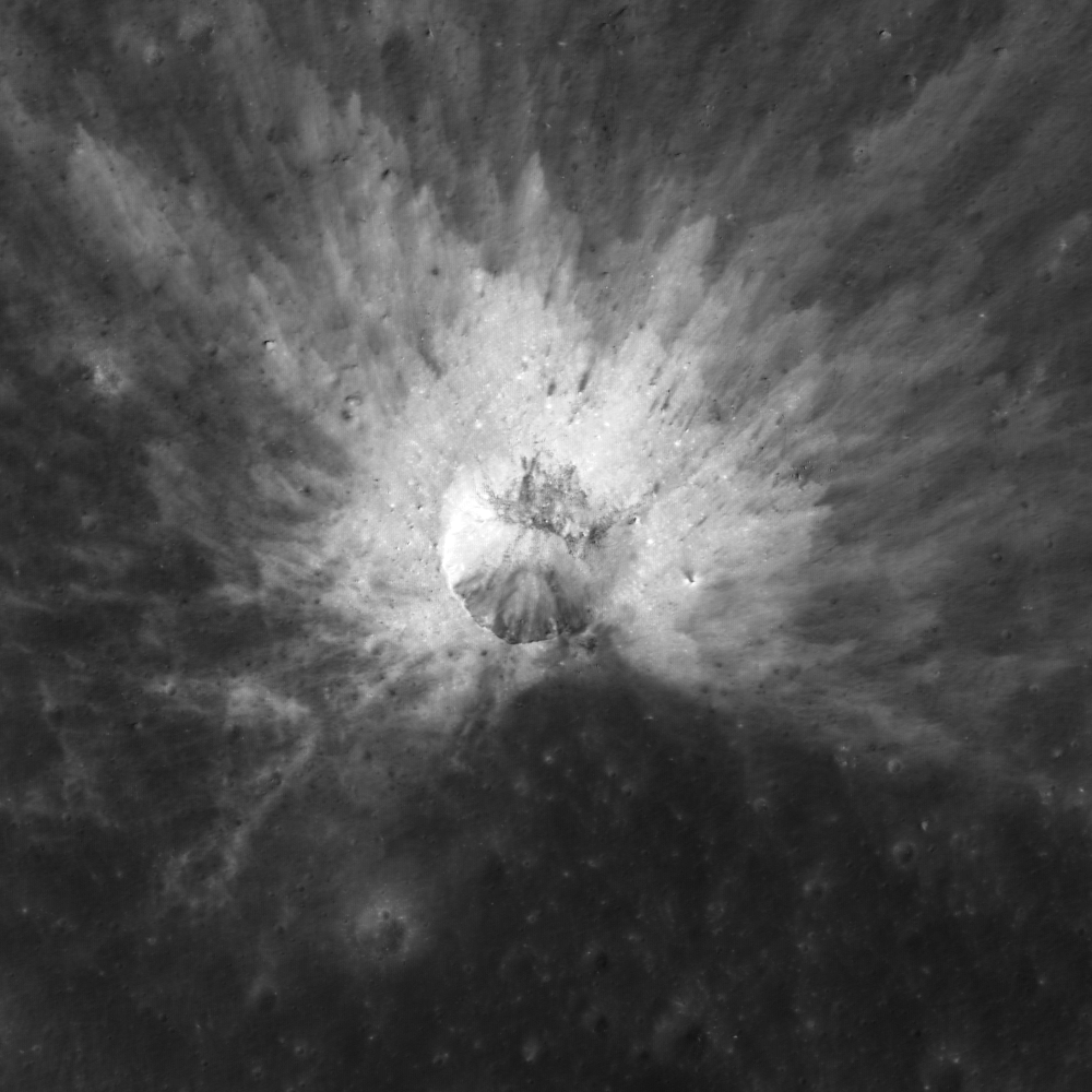
A fresh young (Copernican) 330 meter-wide impact refreshed the otherwise optically mature Farside Highlands Terrain (FHT), from LROC Narrow Angle Camera (NAC) observation M1104423389L, LRO orbit 15067, October 9, 2012 [NASA/GSFC/Arizona State University].
Sarah Braden
LROC News System

This Copernican-aged crater is located in the highlands at 41.571°N, 227.129°E. While the crater diameter is ~330 meters, the rays of high reflectance ejecta extend more than two crater diameters from the rim in all directions. The material in the ejecta is higher in reflectance compared to the surrounding material because it was recently exposed to the surface. Recently exposed material is called fresh since it is relatively unaffected by space weathering processes.

The layers of ejecta are thicker closer to the crater rim, and become progressively thinner with distance from the crater rim. Also the rays of ejecta furthest from the crater rim mix more with the surrounding material. The overall effect causes higher reflectance near the rim of the crater and lower reflectance of the ejecta as you get further away from the rim.

LROC Wide Angle Camera (WAC) 100 meter monochrome Global Mosaic provide at least some context for an area of the Moon being explored at high resolution in the 21st century [NASA/GSFC/Arizona State University].
Explore the entire NAC frame, HERE.

Related Images:

Wednesday, December 5, 2012

JPL releases most detailed map of lunar gravity

From JPL's newly released GRAIL Map of Moon's Crust, a still frame centered near 240° East, for comparison with the LROC WAC orthographic projection at the end of the previous post [NASA/JPL/MIT]
The GRAIL twin spacecraft, "Ebb" and "Flo," in close orbit around the Moon, have generated the highest resolution gravity field map of any celestial body.

The new map, created by the Gravity Recovery and Interior Laboratory (GRAIL) investigators, is allowing scientists to learn about the Moon's internal structure and composition in unprecedented detail. Data from the two "washing machine-sized" spacecraft also will provide a better understanding of how Earth and other rocky planets in the solar system formed.

The gravity field map reveals an abundance of features never before seen in detail, tectonic structures, volcanic landforms, basin rings, central peaks and numerous simple craters. Data also show the Moon's gravity field is unlike that of any known rocky planet.
These are the first scientific results from the prime phase of the mission, and they are published in three papers in the journal Science.

"What this map tells us is, more than any other celestial body we know, the Moon wears its gravity field on its sleeve," said GRAIL Principal Investigator Maria Zuber of the Massachusetts Institute of Technology. "When we see a notable change in the gravity field, we can sync up this change with surface topography features such as craters, rilles or mountains."

Zuber says the Moon's gravity field preserves the record of impact bombardment that characterized all terrestrial planetary bodies and reveals evidence for fracturing of the interior extending to the deep crust and possibly the mantle. This impact record is preserved, and is now more precisely measured, on the Moon.

The probes revealed the bulk density of the moon's highland crust is substantially lower than generally assumed.

From JPL's newly released GRAIL Gravity Map of the Moon [NASA/JPL/MIT].
This low-bulk crustal density agrees well with data obtained during the late Apollo "J" missions, that samples returned by astronauts are indicative of global processes.

"With our new crustal bulk density determination, we find the average thickness of the moon's crust is between 34 and 43 kilometers, about 10 to 20 kilometers thinner than previously thought," said Mark Wieczorek, GRAIL co-investigator at the Institut de Physique du Globe de Paris. 

"With this crustal thickness, the bulk composition of the moon is similar to that of Earth. This supports models where the moon is derived from Earth materials that were ejected during a giant impact event early in solar system history."

The map was created by the spacecraft transmitting radio signals to define precisely the distance between them as they orbit the Moon in formation. Orbiting over areas of greater or lesser gravity related to visible features, such as mountains and craters, and masses hidden beneath the lunar surface, the distance between the two spacecraft changed slightly.

"We used gradients of the gravity field in order to highlight smaller and narrower structures than could be seen in previous datasets," said Jeff Andrews-Hanna, a GRAIL guest scientist with the Colorado School of Mines. "This data revealed a population of long, linear gravity anomalies, with lengths of hundreds of kilometers, crisscrossing the surface. These linear gravity anomalies indicate the presence of dikes, or long, thin, vertical bodies of solidified magma in the subsurface. The dikes are among the oldest features on the moon, and understanding them will tell us about its early history."

While results from the primary science mission are just beginning to be released, the collection of gravity science by the lunar twins continues. GRAIL's extended mission science phase began August 30 and concludes December 17. As End of Mission nears, the spacecraft will operate at lower orbital altitude.

When launched in September 2011, the probes were named GRAIL A and B. They were renamed Ebb and Flow last January by elementary students in Bozeman, Montana, following a nationwide contest. Ebb and Flow were placed in near-polar, near-circular orbit at an altitude of approximately 55 kilometers, December 31, 2011 and January 1, 2012, respectively.

NASA's Jet Propulsion Laboratory in Pasadena, Calif., manages the mission for NASA's Science Mission Directorate in Washington. GRAIL is part of the Discovery Program managed at NASA's Marshall Space Flight Center in Huntsville, Ala. Lockheed Martin Space Systems of Denver built the spacecraft.

To view the lunar gravity map, visit http://bit.ly/grailtour . For more information about the mission, visit HERE .

A Tiny, Glancing Blow

An oblique impact created a beautiful asymmetrical ejecta pattern on the farside highlands, photographed from LRO October 10. LROC Narrow Angle Camera (NAC) observation M1104509842L, spacecraft orbit 15079, resolution 1.2 meters per pixel over a field of view 696 meters wide. With the Sun high, sheer reflectance, hinting at rough and fresh terrain, is emphasized. In an earlier, closer observation below reflectance gives way to topography under a high angle of incidence [NASA/GSFC/Arizona State University].
Sarah Braden
LROC News System

The ~220 meter diameter impact crater, located at 6.258°N, 215.101°E , just east of the unnamed crater highlighted in yesterday's Featured Image, was caused by an obliquely impacting asteroid or comet.

What is an oblique impact, and how do we know that this crater was formed by an oblique strike? 

The term oblique impact implies an impact angle of 15 degrees or less. The impact angle is the angle between the surface and the vector that represents the direction of travel of the impactor. 

A slightly closer look, under a greater angle of incidence (71.25°), at the rough ejecta and pressure wave pattern immediately beyond the north rim of the small glancing impact, from an earlier LROC NAC observation that unfortunately only overlaps the Featured Image at these points. The smaller grooves overlap those from the unnamed crater to the west (upper left). LROC NAC M118444752L , orbit 2589, January 18, 2010; resolution 1.09 meters from 52.43 kilometers [NASA/GSFC/Arizona State University].
The greater than 15 degree impact angle results in a number of diagnostic features including asymmetric ejecta and non-circular crater shapes. In the Featured Image, it is clear that this impact has asymmetric ejecta since the area immediately to the south of the crater is "missing" its high reflectance ejecta. 

The asymmetry of the small impact, its missing south half, are clearly seen in this LROC Wide Angle Camera (WAC) mosaic of sequential LROC WAC observations in orbits 11104 and 11105, November 18, 2011; 62 meters resolution over a roughly 30 km-wide field of view [NASA/GSFC/Arizona State University].
The small crater's location, high amidst the highest elevations on the Moon, in the Farside Highlands Terrain (FHT), is indicated by the arrow at center, that also shows slope angles throughout the region are not as level as they might seem in close photography. LROC WAC Digital Terrain Model (DTM) hemispheric orthographic projection centered on 240° E (below) [NASA/GSFC/DLR/Arizona State University].
The region in hemispheric context, orthographic projection centered on 0°N, 240°E [NASA/GSFC/DLR/Arizona State University].
Due to the low angle of impact, the ejecta has more momentum in the direction of travel of the impact, which causes the asymmetric ejecta patterns. The area with the least ejecta is sometimes called the "zone of avoidance," and it indicates the impactor flight direction. In this case, the impactor was traveling from the south to the north when it hit the lunar surface (north is up in the Featured Image).

Explore the entire NAC frame HERE for more impact features.

Related Images:
Slice of Mare
How did I form?
Asymmetric Ejecta

Tuesday, December 4, 2012

"Physics is fun, especially on the Moon!"

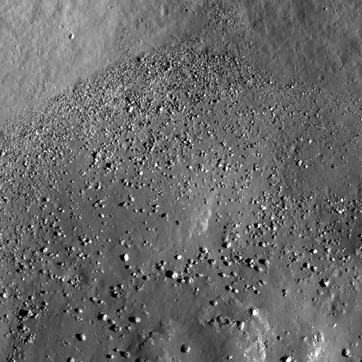
A gradational distribution of boulders inside a crater. LROC Narrow Angle Camera (NAC) observation M176224625L, LRO orbit 11105, November 18, 2011; field of view 500 meters across at 0.51 meters resolution from 47.61 kilometers, incidence angle 55.29° [NASA/GSFC/Arizona State University].
Sarah Braden
LROC News System

A distribution of boulders within the floor of an unnamed crater demonstrates physics at work. In the Featured Image (located in the lunar highlands at 6.275°N, 214.770°E) you can see that smaller boulders are (on average) closer to the boundary where the wall of the crater meets the floor. As distance increases from this boundary, the size of the individual boulders increases.

Why is this happening?

The larger boulders have more kinetic energy at the bottom of the slope due to their greater mass. Kinetic energy is 1/2 the mass times the velocity squared. So at the bottom of the crater wall, the more massive boulders will have more kinetic energy than the small boulders, even though they are all subject to the same acceleration due to the Moon's gravity. The crater floor is relatively flat, so the larger boulders will travel further than the small boulders before coming to a halt. An alternative explanation is that larger boulders originate preferentially from the rim of the crater and thus fall from a greater height on average compared to small boulders. Either way, the larger boulders have more kinetic energy when the reach the bottom of the crater.

Full width, 4000 lines in a mosaic of both left and right frames of LROC NAC M176224625 shows the tumbled mix of impact melt typical of craters with larger floors. The field of view at shown at full resolution in the Featured Image is the upper most contact between the crater floor and north wall [NASA/GSFC/Arizona State University].
August 2, 1971, Hadley Rille Delta Apollo 15 commander Dave Scott demonstrates the basic physics of falling objects on the surface of an airless body. In tribute to Galileo, Scott simultaneously drops a 1.32-kg aluminum geological hammer and a 0.03 kg falcon feather and both objects, falling at identical acceleration, reach the surface at the same time [NASA].
During the Apollo 15 mission, Commander David Scott performed a related physics experiment live for the TV cameras! You can watch the video here: Apollo 15 Hammer and Feather Drop. He dropped a rock hammer and a feather from the same height at the same time. The point of the experiment was to show that in an environment with no atmospheric drag (a vacuum) the feather and the hammer will fall at the same speed (and hit the ground at the same time) regardless of the difference in mass. This basic idea is attributed to Galileo. Read more about the Apollo 15 experiment HERE.

Physics is fun, especially on the Moon!

LROC Wide Angle Camera (WAC) context image, photographed as the LROC NAC (and LROC Featured Image) captured a much higher resolution field of view (asterisk) of the boulder distribution deep within this unnamed, young 12 km crater in the farside lunar highlands. LROC WAC observation M176217257C (643nm) LRO orbit 11105, November 18, 2011; resolution 62 meters per pixel [NASA/GSFC/Arizona State University]

The crater is shown in greater, smaller-scale context, within a roughly 82 km-wide field of view; from a mosaic of LROC WAC observations captured in orbits 11104 and 11105, November 18, 2011. The wider region, northwest of Vavilov crater and northeast of the ancient South Pole-Aitken impact basin, is characterized by some of the highest elevations (and thickest crust) on the Moon. The nearest named crater, Artem'ev L, at upper right, received its official designation in 2006 [NASA/GSFC/Arizona State University].

Explore the entire NAC frame, HERE.

Related LROC Featured Images:
Crater Covered With Boulders
Ray of Boulders
Sampling a Central Peak

Monday, December 3, 2012

Reflecting on the ice of Mercury and the Moon

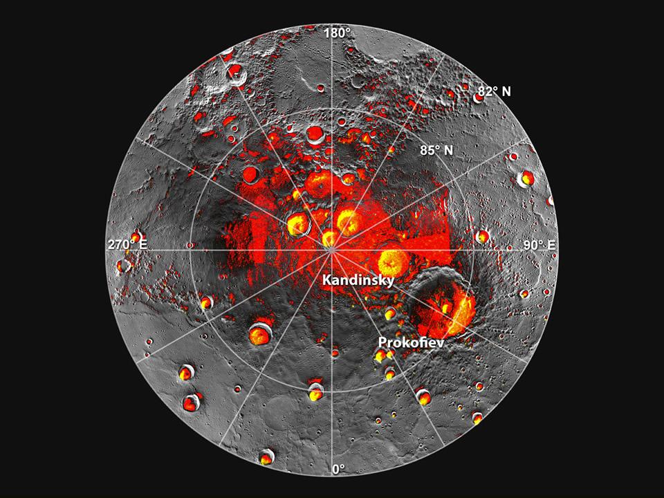
Composite image of the north pole of Mercury. Red are the areas of permanent shadow; yellow delineates radar bright deposits mapped from Earth. Data are plotted on a photomosaic of MESSENGER images [NASA].
Paul D. Spudis
Smithsonian Air & Space

Mercury – the planet, not the element – was in the news this past week.  For some time, we had suspected that the poles of Mercury might harbor deposits of water ice.  This – on a planet so close to the Sun that the surface temperature at the equator is hot enough to melt lead!

Yet like the Moon, Mercury’s spin axis is perpendicular to the plane in which it orbits the Sun.  This means that large craters near Mercury’s poles lie in permanent shadow (“shivering” around -170° C), unaffected by the Sun’s searing heat (equivalent to more than eleven times the solar flux we get on Earth).  As on the Moon, these permanently shadowed areas get heat from only two sources – the 3 K background heat of space, created during the Big Bang some 15 billion years ago, and whatever heat is being generated now from the deep interior (a quantity that geophysicists call the heat flow of a planet).

Large planets (like Earth) generate heat mostly from the decay of radioactive elements deep inside them.  This heat is lost largely through the phenomenon of volcanism, in which melted rock from the interior is erupted onto a planet’s surface as lava and ash.  Smaller planets and moons likewise experience this heating and volcanism, but because they are have lower overall contents of heat-producing elements, their volcanic episodes occurred in the distant past.  Much of the heat of these smaller planets has been largely dissipated.  Thus, on Mercury, we suspect that the overall heat flow is very low, resulting in extremely cold temperatures on the floors of its permanently shaded polar craters.

For many years, astronomers have studied Mercury with radio telescopes from Earth (using radar to make images of its surface).  Because the orbital inclination of Mercury is relatively high (about 7°), we can get a fairly good look into the interiors of the polar craters.  Interestingly, even though Mercury is much farther away than the Moon, we can see more of the mercurian polar areas because of this relatively high orbital inclination (the Moon’s orbital plane is inclined only 5°).  These radar pictures showed an amazing and unexpected feature – the dark areas are filled with material that is highly reflective at radio frequencies, properties similar to the surfaces of the icy moons of Jupiter (Europa, Ganymede and Callisto).

These results were so unexpected and startling that debate raged for many years whether these deposits really were what they appeared to be: water ice.  Facts are stubborn things and few materials have radio properties similar to ice.  Some suggested that sulfur might be an alternative explanation, but provided little evidence for such behavior.  Moreover, another moon of Jupiter, Io, which has a surface largely composed of sulfur, does not show the radar brightness or “glint” seen on the other, ice-rich Jovian moons.

The debate on the nature of the Mercury polar deposits has now been settled with the release of new data from the MESSENGER mission.  Launched on August 3, 2004, with insertion into obit around the planet on March 18, 2011, the spacecraft has been taking pictures and making measurements of Mercury for the last two years.  We have mapped the extent of darkness near the poles, measured the temperatures of the surface inside these regions, and detected the presence of significant amounts of hydrogen there.  All of these results are strongly supportive of the water ice interpretation.

The existence of ice near the poles of Mercury supports the case for water ice on our own Moon, although there are some significant differences between the two occurrences.  Like Mercury, the Moon’s spin axis is nearly perpendicular to the plane of its orbit around the Sun.  The similarity of the terrain of both bodies results in deep holes that hide large expanses of terrain from the glare and heat of the Sun.  Both objects have been volcanically active in the past, but not today, meaning that the average rates of heat flow on both are low.  These properties result in the creation of polar “cold traps” in which any entering volatile substance (such as water molecules) cannot escape.

The solid bodies of the inner Solar System are constantly hit by debris from comets and asteroids.  This material contains water, both in free form and bound within hydrous minerals.  On smaller objects (like the Moon and Mercury), most of this water is lost to space, but we suspected that some of it might be retained within these dark cold traps near the poles.  Now we know that such a process does occur.

Differences between the Moon and Mercury result in differing amounts and settings for their polar deposits.  Being much closer to the Sun, one might expect Mercury to contain less water ice, but a variety of evidence suggests that the opposite is the case.  The polar ice of Mercury appears to be greater in extent and thickness than comparable deposits on the Moon.  This probably results from two factors.  First, Mercury is a bigger object, with a surface gravity about twice that of the Moon.  Thus, it is more difficult for water to “escape” from Mercury.  Second, the closeness of Mercury to the Sun (the edge of biggest gravity well of the Solar System) results in a higher flux of cometary impacts there than experienced in the Earth-Moon system.  So more water is being added to Mercury, where it is more easily retained.

Nonetheless, both Moon and Mercury have similar polar environments and processes.  The long debate – a scientific controversy for over 50 years – about water at the poles of these objects has been resolved.  The next steps will be to characterize these deposits in situ using a soft lander and selected instruments to measure the amounts, states and distributions of water in the polar areas.  Because of the great difficulty in even getting into orbit around Mercury (let alone landing there), doing this first on the Moon will mostly likely happen first.  So, here again is another rationale for sending a robotic surveying lander and rover mission to the poles of the Moon – in addition to characterizing these areas for our future presence there, by inference, we will also learn about the polar processes on and environment of Mercury.

A planetary “two-fer.”  Let’s get on with it.

Originally published at his Smithsonian Air & Space blog The Once and Future Moon, Dr. Spudis is a senior staff scientist at the Lunar and Planetary Institute. The opinions expressed are those of the author and are better informed than average.

Saturday, December 1, 2012

Priscilla & Alan & Delia & Harold, Four of a Kind

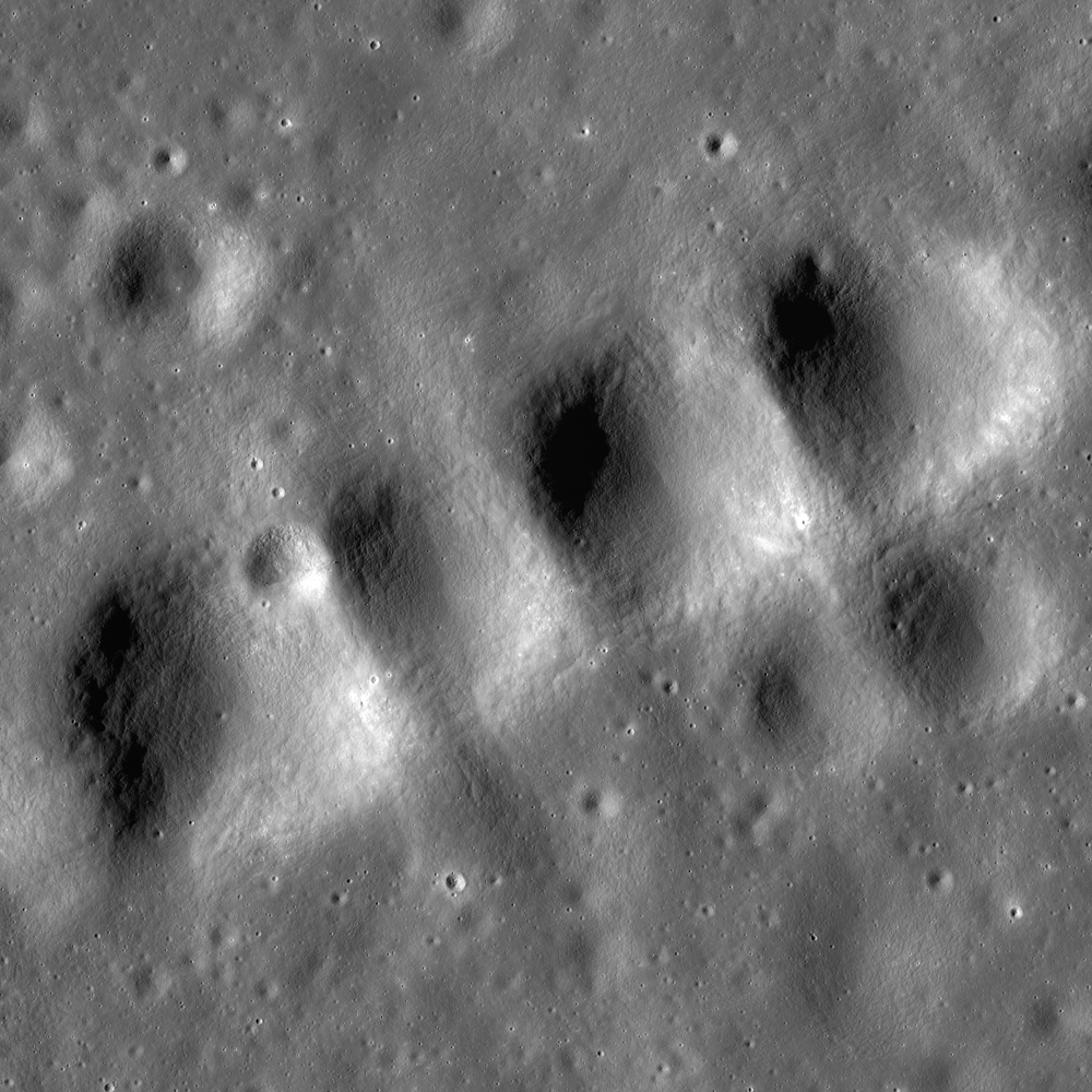
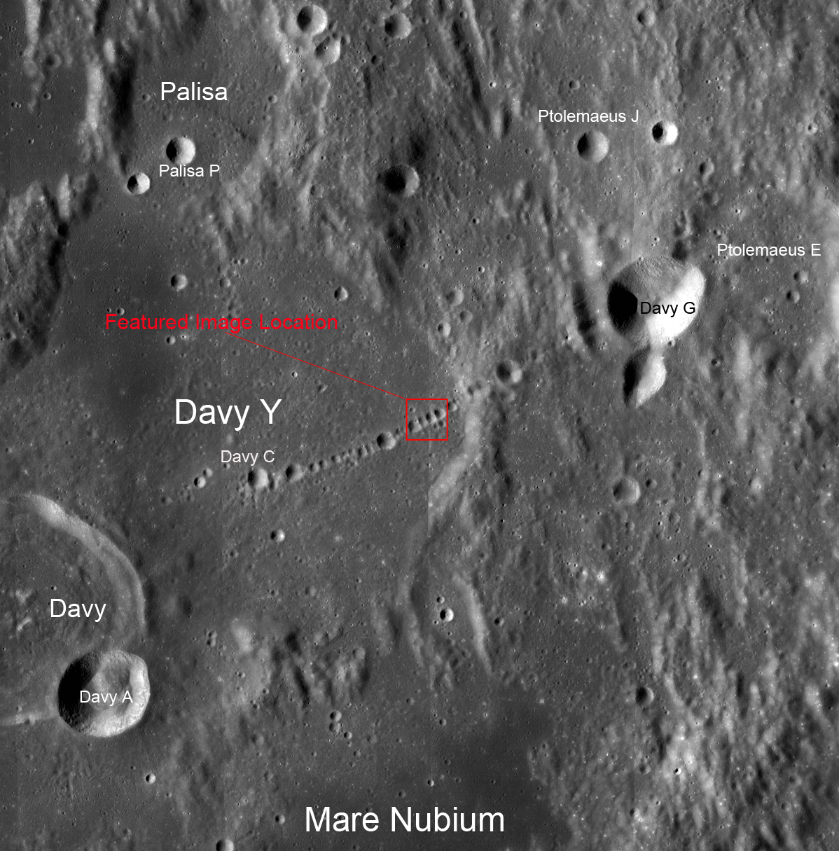
Evenly spaced craters stand out in the Catena Davy crater chain (11.0°S; 6.2°W). From a mosaic of both the left and right hand frames of LROC Narrow Angle Camera observation M181208790, LRO orbit 11818, from 96.21 kilometers on January 14, 2012; illumination incidence angle 66.11° from the west, resolution over a field of view approximately 6 kilometers across (in the original) 0.98 meters per pixel [NASA/GSFC/Arizona State University].
James Ashley
LROC News System

Many readers will remember the much publicized events of July 1994, when 21 ice fragments comprising Comet Shoemaker-Levy 9 impacted one after another with the atmosphere of Jupiter over a six-day period. Large, dark blotches were visible through backyard telescopes on the Jovian cloud tops for several months afterward. The largest impact produced energy estimated at six million megatons equivalent of trinitrotoluene (TNT).

What does comet Shoemaker-Levy 9 have to do with today's Featured Image?

Shoemaker-Levi 9 on May 17, 1994, discovered a year before widely-viewed sequential impacts on the upper atmosphere of Jupiter
Very high resolution image of a 242 meter-wide part of the north wall and rim of one of the four small craters of Catena Davy, 1.87 km-wide "Delia," during LRO's low altitude maneuvers over the near side of the Moon in 2011; spacecraft orbit 9928, August 17, 2011 (LROC NAC M168245384R). At 42 cm per pixel, from only 27.58 km, block material can be seen continuing to be slowly shed from the crater's very degraded rim, testifying to great age [NASA/GSFC/Arizona State University].
Two thirds of 1.87 km Delia crater, of Catena Davy, in a highly resampled 5000 lines from M168245384R. The rectangle designates the area of the north wall and rim above [NASA/GSFC/Arizona State University].
Names for these member craters of the Catena Davy chain, adopted by the International Astronomical Union in 1976. Full-width reduction of the LROC NAC observation M181208790. In Russian Doll fashion, the rectangle approximates the field of view shown immediately above, though from a later observation and a different angle of incidence [NASA/GSFC/Arizona State University].
The linear array of craters known to lunar scientists as Catena Davy on the Moon, a portion of which is shown above, is thought to have been produced by a Shoemaker-Levy 9-like string of objects traveling through space along identical orbits. Each object encountered the surface at slightly different times, produced by the objects' separation along the orbit. A small amount of lunar rotation as it moves around Earth through its own orbit results in an offset of each impact feature from its predecessor, producing a linear chain of impacts.

NASA Lunar Mapping and Modeling Program (LMMP) ILIADS application view shows the view from low orbit in the southwest over Catena Davy. The circle designates the four member craters in the LROC Featured Image [NASA/GSFC/Arizona State University].
As was seen with Shoemaker-Levy 9, a weakly held together planetary body (such as a comet or rubble pile asteroid), can be fragmented and separated by tidal forces if it comes within the Roche limit of a larger body, and drawn out into such a string of objects. Similar crater chains have been discovered on several moons of the outer planets where the gravity wells of these gas giants are sufficient to pull bodies apart in this way. What might have done this within the Inner Solar System, where planetary tidal forces are weaker? In the case of Catena Davy, where the impact craters rest "shoulder to shoulder," the impactors may have been pulled apart shortly before impact, and struck the Moon in a rapid-fire sequence of short duration, rather than having been widely separated and striking over time. What clues would you look for to improve our understanding of what actually happened?
Early LROC Wide Angle Camera (WAC) monochrome observation of a 48 km wide field of view, including Catena Davy. LROC WAC M119896473M, spacecraft orbit 2802, February 4, 2010; resolution 57 meters from 40.85 km [NASA/GSFC/Arizona State University].
The LROC Featured Image release contextual WAC mosaic showing Catena Davy in the context of a field of view about 120 km across [NASA/GSFC/Arizona State University].

Comet Shoemaker-Levy 9 awakened world interest in the possibility for asteroid and comet impacts on Earth in modern times, the last significant example of which occurred on June 30, 1908 near the Podkamennaya Tunguska river in Northern Russia. That air-burst meteoroid encounter leveled more than 2,000 square kilometers of forest, but no human life was lost because no humans were present in this remote corner of planet Earth. The situation would be very different if such an event occurred over a metropolitan area. While these encounters are infrequent, they do constitute a natural hazard, and should be taken as seriously as other natural hazards (e.g. earthquakes, tsunamis, tornadoes, hurricanes, etc.).

Most of the impact hazard risk is associated with single asteroid bodies, not cometary strings. Astronomers are currently conducting sky surveys to identify as many of these objects as possible, determine their orbital parameters, and find out if any are currently on a collision course with Earth. As with all natural hazards, future incidents are indeed certain if such precautions are not taken. Click HERE to open the NAC mosaic for this feature. Additional discussion on crater chains can be found in our Mare Orientale post from March 2010, where the cause is likely to be from secondary, not primary, impacts.