Showing posts with label Rupes Recta. Show all posts

Tuesday, July 15, 2014

Birt E and the fiery rift valleys of Nubium

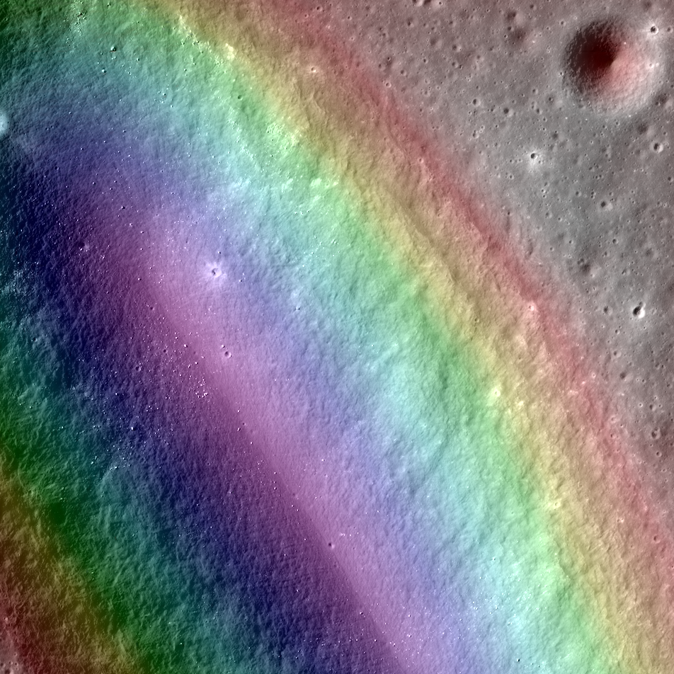
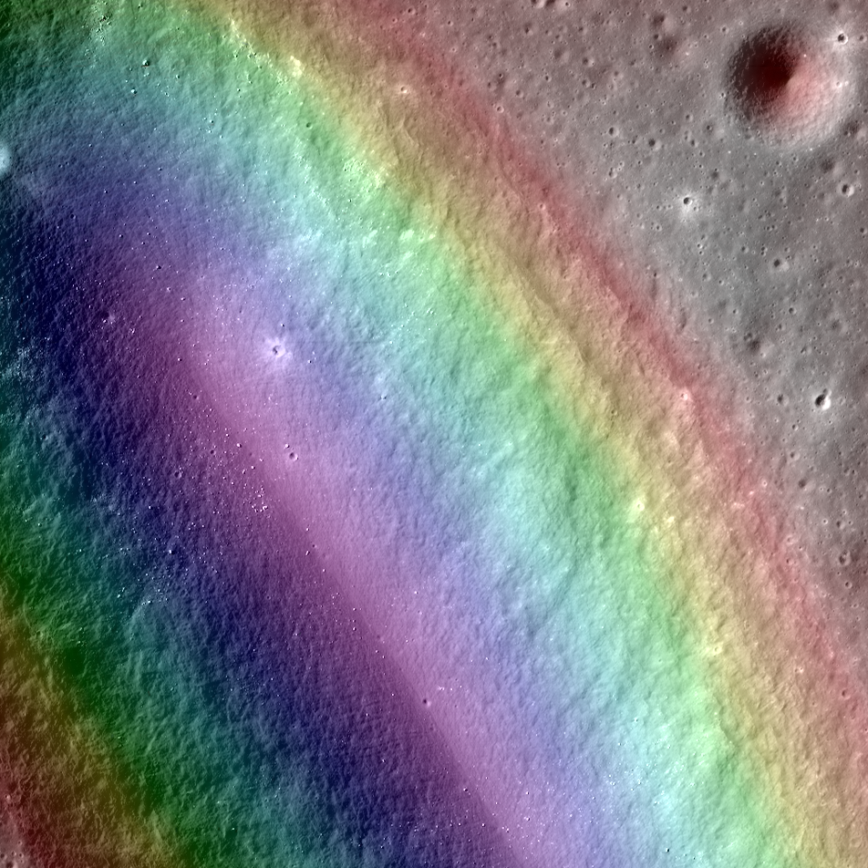
LROC Narrow Angle Camera-derived Digital Terrain Model (DTM, color gradations superimposed) on a close-up view along the northeastern long axis of Birt E (5.34 km; 20.72°S, 350.337°E), the vent structure of Rima Birt, a sinuous rille in east Mare Nubium immediately west Rupes Recta. The vent is thought to be a source region for pyroclastic flows that traced out Rima Birt. The mare basalt, visible as slightly darker material in a fan spreading north from the vent, is older than 3.4 billion years. A roughly 3 km-wide field of view from LROC NAC mosaic M1144849711LR, LRO orbit 20750, January 20, 2014; 46.21° incidence angle, 84 cm resolution from 78.77 km over 20.69°S, 351.11°E [NASA/GSFC/Arizona State University].
Aaron Boyd
LROC News System

Birt E (20.72°S, 350.337°E) was not created like most craters on the Moon; there was no meteorite impact. Lava sputtered out of this pyroclastic vent in Mare Nubium over 3.4 billion years ago, dispersing lava onto the surface and leaving the crater we see today.

How can we tell it is a volcanic vent and not an impact crater?

Impact craters and volcanic vents can be differentiated because vents often have an irregular or elongated shape (as with Birt E). Impact craters are usually circular in shape, created by the shockwave during an impact event.

Pyroclastic vent structure at Rima Birt, officially "Birt E," though it is not a crater; west of Rupes Recta in east Mare Nubium. 4.66 km-wide field of view from LROC NAC mosaic M1144849711LR [NASA/GSFC/Arizona State University].
Also, the vee-shape of this crater is likely a product of the formation mechanism. Vee-shaped vents are thought to be formed from a pyroclastic eruption. Gasses fractionating out of the liquid rock create violent events during eruptions. Explosive eruptions created the shape that we see today, but Birt E could have had a complex history with effusive eruptions forming Rima Birt, the short sinuous rille flowing from Birt E to the south-southeast.
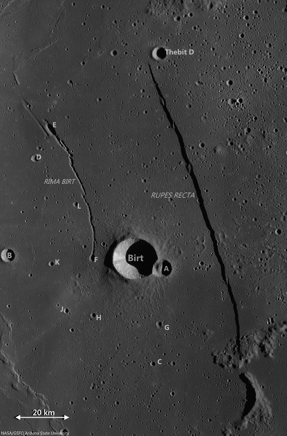
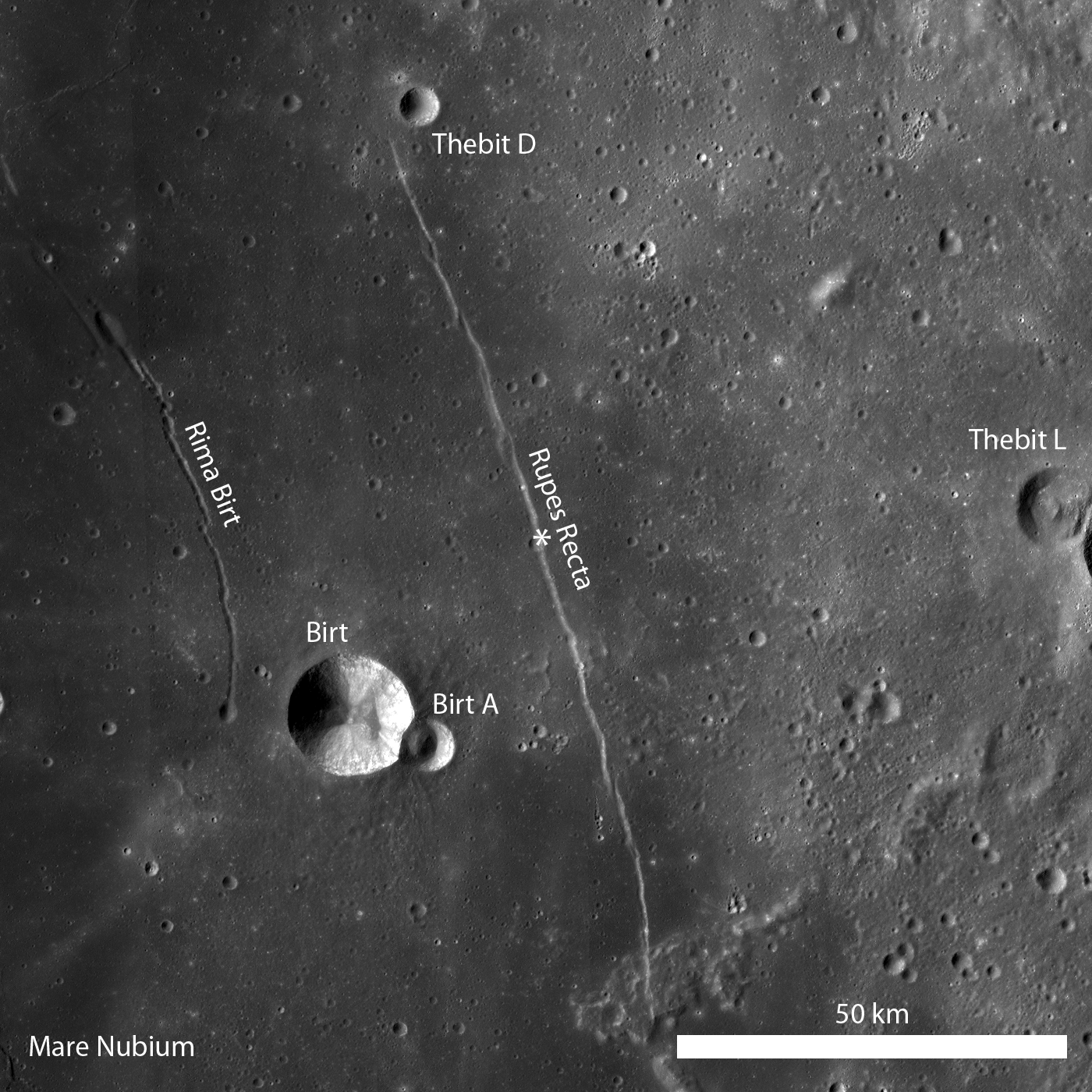
Birt crater group and Rupes Recta, the eye-drawing structure in telescopic views of Mare Nubium. (See a larger, unnoted reproduction HERE.) LROC Wide Angle Camera (WAC) monochrome (604 nm) mosaic stitched from observations swept up over three sequential orbital passes June 10, 2011; incidence roughly 78° and 58 meters per pixel resolution, from 43 km [NASA/GSFC/Arizona State University].
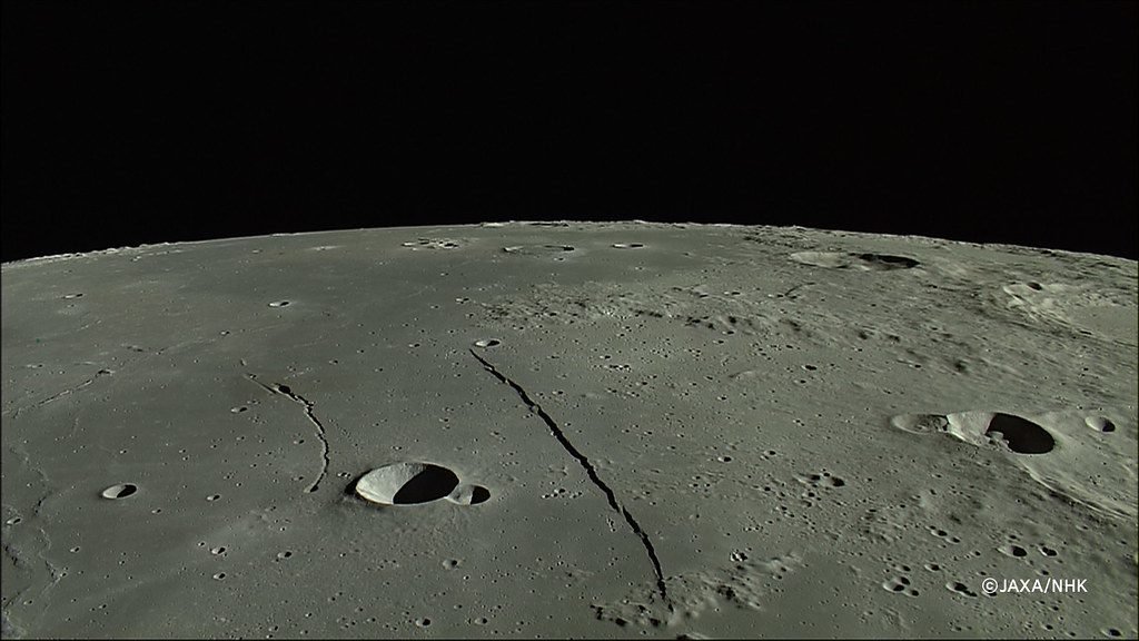
East Mare Nubium, an orbital view north from 100 km altitude, an HDTV still from Japan's lunar orbiter Kaguya (SELENE-1) in 2008. (See the wallpaper-sized release HERE.) [JAXA/NHK/SELENE].
Over long enough time scales Birt E will be filled in with ejecta from newly formed craters around Mare Nubium or by mass wasting of the walls into the crater. Let’s enjoy this ancient crater today while we still can!
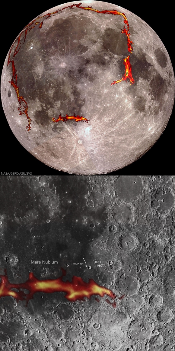
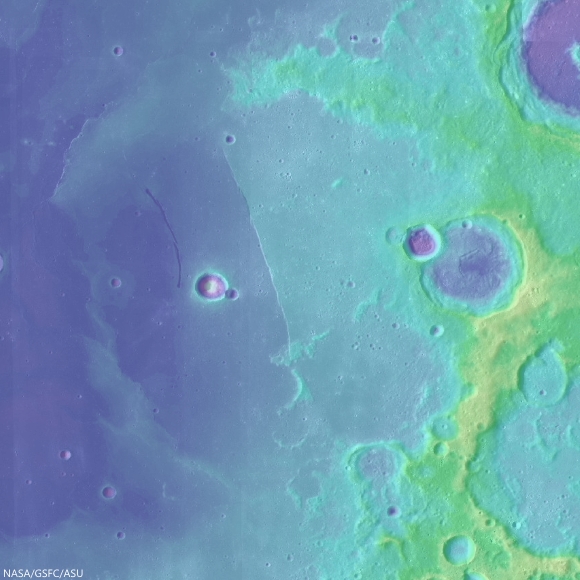
As the GRAIL gravity probes mapped the Moon's basic anisotropy in 2012 detecting the densities of "deep fiery rift valleys," a probable source of a half billion year period of pyroclastic volcanism surrounding the Moon's Procellarum terrain, added important pieces to the tossed puzzle of the Moon's morphology. In the newest maps of the Moon's own squarish "ring of fire," there is still a missing link under the Southern Highlands, but a source for the multiple inundations of the nearside's lowlands, weight that may have created the Straight Wall fault in east Mare Nubium, may have been found [NASA/GSFC/SVS].
LOLA laser altimetry color-coded over LROC WAC 100 meter global mosaic demonstrates where Rupes Recta marks a neat break in the continuity of the floor of an otherwise almost entirely erased 190 km crater. The weight of repeated inundations gradually sloped that crater's floor 1500 meters in elevation deeper on the west side, gradually, aside from the 100 to 300 meter "snap" represented by Rupes Recta [NASA/GSFC/Arizona State University].
Check out the topography in the full NAC DTM HERE.

Related Posts:

Wednesday, February 9, 2011

LROC: Rupes Recta


Artful Lunar Picture of the Day (LPOD) contributor Maurice Collins of New Zealand created this mosaic of LROC Wide Angle Camera images, swept up at local sunrise, and demonstrates why Rupes Recta is easier to spot when the Moon is just past First Quarter as seen from Earth. The change in elevation is not unusually high, for the Moon, but the rift is consistent (even if segmented) throughout its more than 100 kilometer length. The Straight Wall is consistent with a change in topography, if not age and stratigraphy, dividing an eastern zone from a western slope, both within an inundated crater broken in half by the weight of later melt pressing down on the interior of Mare Nubium. This gentle rift casts a long shadow at sunrise, however, one that gradually thins until the Moon waxes Full, and afterward it stays visible in modest telescopes [NASA/GSFC/Arizona State University/MoonScience].

EDITOR'S NOTE: Every 90 days, each time Dr. Mark Robinson's Lunar Reconnaissance Orbiter Camera (LROC) team at Arizona State University releases its latest voluminous batch of low-orbit lunar photography, one of several bench mark locations we immediately search for updates has been the familiar "Straight Wall," Rupes Recta. LROC Featured Image February 9, 2011 examines and better explains a feature discussed here in a post originally uploaded July 8, 2010.

For a review of our many posts (and images) featuring Rupes Recta, we recommend the reader take a side trip HERE, or simply examine the list of relevant Lunar Pioneer links below the list of LROC "Related Posts" below.

In July, when after we first began manipulating the same frame LROC released below, we described the image above as, a "closer look at the crater straddling the Straight Wall near 21.6°S, 352.2°E, The character of each half of the plain divided by the rift appears similar. Also, at this point in this montage, consisting of both the right and left frames of LROC Narrow Able Camera observation M122264663. For a Wallpaper-sized view of the above image, click HERE [NASA/GSFC/Arizona State University].


Rupes Recta is a well-known linear rille over 100 kilometers long, familiar in amateur telescopes, west of the central meridian in the Nearside southern hemisphere, seen here in an annotated portion of LROC Wide Angle Camera (WAC) monochrome mosaic; illumination from the west (left), the asterisk denotes the location where LROC Narrow Angle Camera (NAC) observation M122264663 intersected the fault, in the LROC Featured Image below [NASA/GSFC/Arizona State University].

Lillian Ostrach
LROC News System

Several weeks ago LROC featured a series of WAC monochrome mosaics of some of the most spectacular sinuous rilles on the Moon (Rimae Posidonius, Vallis Schröteri, and Rimae Prinz). Unlike sinuous rilles, linear rilles (or graben) are not believed to primarily result from lunar volcanism. Linear rilles are surface manifestations of structural faulting that formed when the lunar crust was pulled apart. The widths of these linear rilles range from as little as a few meters to kilometers across; Rupes Recta is between 1 - 3 km wide across its length. In addition, Rupes Recta is composed of several en echelon segments - the linear rille is not a single, uninterrupted 100 km length fault! There are at least 5 large fault segments visible at the LROC Wide Angle Camera scale (100 meters/pixel) ranging from around 8 to 50 kilometers in length.


Cross-cutting relations between Rupes Recta and an impact crater are evident in this subset of LROC NAC observation M12264663R (LRO orbit 3151, March 3, 2010). The cliff-face of Rupes Recta is noted by the arrows on the right side of the image. At some point after the formation of Rupes Recta an impact occurred and excavated material from the fault wall. The arrows on the left side (forming a somewhat-curvilinear path) denote the crater wall. Subsequent down-slope movement of eroded debris and blocks is visible. Image field of view is 840 meters, illumination from the left, and a low-incidence angle highlights albedo variations [NASA/GSFC/Arizona State University].

What cross-cutting relationships can you determine in the LROC WAC monochrome mosaic? How does the full LROC NAC image change your view of Rupes Recta?

Related posts:
Linear Graben

Lunar Pioneer Posts:
A second NAC cross-section of Rupes Recta
More on that second Rupes Recta close-up
Rima Birt and Rupes Recta
LOLA/LROC: Hunting for ancient impact basins (LROC)
More Kaguya Terrain Camera images
Paul Spudis: Caves on the Moon
Google Moon, Limited (Part One)
A New Era of Lunar Exploration


Segment from the really outstanding LROC WAC monochrome mosaic of the >100 km-long segmented fault east of Mare Nubium in the Nearside southern hemisphere. The northern half of the feature is set apart here to note a cross-fault (upper arrow) first brought to our attention by Charles A. Wood in a discussion posted to his essential Lunar Picture of the Day (LPOD) website. The nearly perpendicular rille is often difficult to pick out in Earth-side photography but unmistakable in the LROC image. The lower arrow, again identifies the location of the impact crater in extreme close-ups above. The image field of view is approximately 40 kilometers [NASA/GSFC/Arizona State University].

Friday, December 31, 2010

More on that second Rupes Recta close-up


Using the Google Earth (>v.5) lunar digital elevation model, after downloading that application's latest catalog of LROC images available through the Planetary Data System (PDS), prepared and updated this past week by Washington University, shows the extent of the only two publicly released LROC Narrow Angle Camera (NAC) observations of "the Straight Wall" of eastern Mare Nubium. Rendered immediately below is a monochrome Wide Angle Camera (WAC) mosaic of the vicinity (stretched, below) that provides a lower resolution but still unprecedented detail of nearby Birt and its ejecta blanket, its companion Birt A and Rima Birt with its "cobra head" feature discussed here July 8, 2010 [NASA/USGS/JAXA/GSFC/Arizona State University/WUSTL/Google Earth].


The 114 km-long landmark "straight wall" with companions Birt and Birt A along the southwest shore of Mare Nubium. With Rima Birt at left, these have often been discussed on the Network. LROC Wide Angle Camera mosaic assembled from images gathered on three successive orbital passes January 7, 2010; processed using LROC WAC Previewer (v.1.6) and stitched together using Microsoft Research Image Composite Editor (ICE) [NASA/GSFC/Arizona State University].