Showing posts with label Faults. Show all posts

Tuesday, December 18, 2012

LROC: Petavius

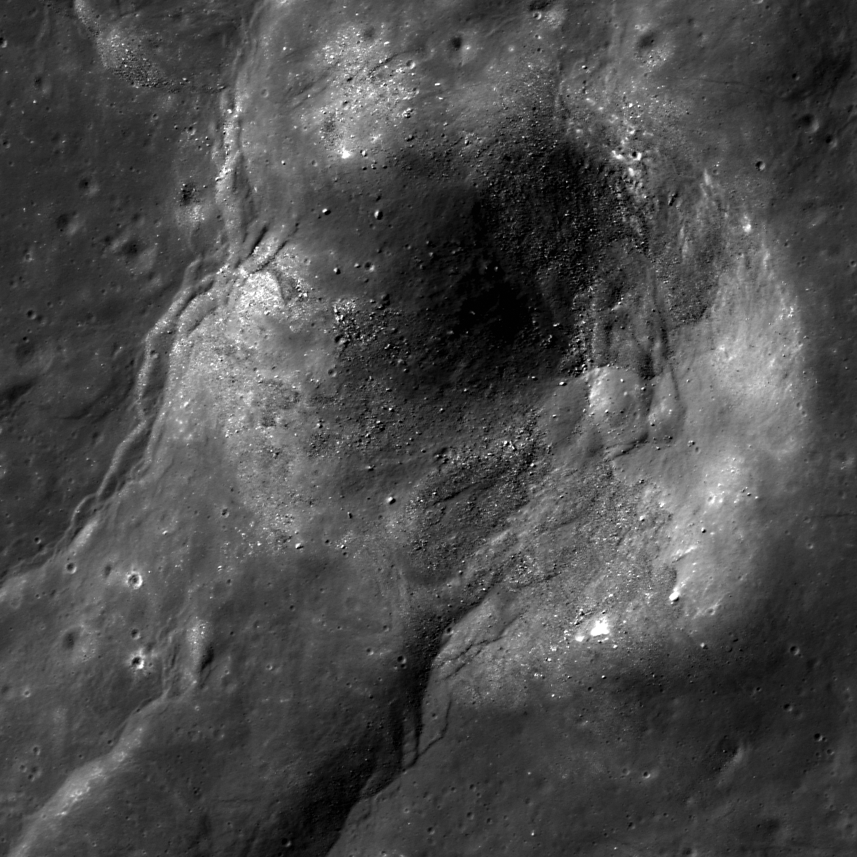
An outcrop exposed in the central peak of Petavius crater revealed in large fracture. From LROC Narrow Angle Camera (NAC) observation M1107889912LE, captured at 0.84 meters per pixel in LRO orbit 15552, November 18, 2012; field of view approximately 840 meters across [NASA/GSFC/Arizona State University].
Drew Enns
LROC News System

Petavius crater, a 177 km crater located at 25.28°S, 60.63°E, is one of an uncommon class of craters that have been modified by post-impact processes. What process could have produced the system of fractures that cut the floor, known as Rimae Petavius? Volcanism is the likely cause. Small patches of mare basalt exist in the north and south extents of the crater floor, which help cement this hypothesis. But unlike other mare filled craters, Petavius crater has only small patches of basalt.

Why did Petavius crater end up with such an extensive fracture system?

Context the LROC Featured Image, 100 km-wide field of view includes the cluster of the Petavius central peaks, composed of material tossed up from great depth when the crater formed in the lower Imbrium age, 3.9 billion years ago. Some darker basaltic material is in the northeast and southeast corners of this image, likely opportunistic intrusions of molten material that "seeped" to the surface following some global event, like the basin forming impact that formed Mare Orientale [NASA/GSFC/Arizona State University].

One hypothesis is that the fractures occurred as a result of volcanic modification. Uplift of the crater floor would occur as magma intruded beneath the floor and fracturing developed as the floor was pushed up. Because Petavius crater was not flooded completely, the fractures were never covered by basalt. The harder question is why is Petavius crater not flooded with basalt?

Wider still context LROC Wide Angle Camera (WAC) mosaic, showing the slumped walls of Petavius. Mosaic stitched from eight sequential observations during orbits 11232 through 11259, November 30, 2011; resolution averaged 70 meters at 68° angle of incidence, from 51 kilometers [NASA/GSFC/Arizona State University].

It is possible Petavius crater did not witness the same style of eruption as elsewhere on the Moon. Or maybe the magma underneath Petavius crater was not buoyant enough to completely flood the surface. Finally, it may simply be that the magma source region was relatively small, and thus only a modest amount of basalt was erupted.

Explore more of Petavius crater in the full LROC NAC observation HERE.

Related Posts:
Rock slide in Rima Hyginus
Pyroclastics and Vent
Archimedes - Mare Flooded Crater!

Petavius is a familiar telescopic landmark from Earth, after the Moon is 3 days old (or 2 days after a Full Moon), though fresher, rougher and less optically mature bright ejecta from smaller neighboring craters like Stevinus and Petavius B tend to overwhelm the scene as the region approaches mid-day. The simulated phase above shows the location of Petavius in relation to the Moon's appearance tonight. Virtual Moon Atlas v.6 using LROC WAC 100 meter textures [VMA].

Friday, June 8, 2012

LROC: 'A Wrinkly Crater'

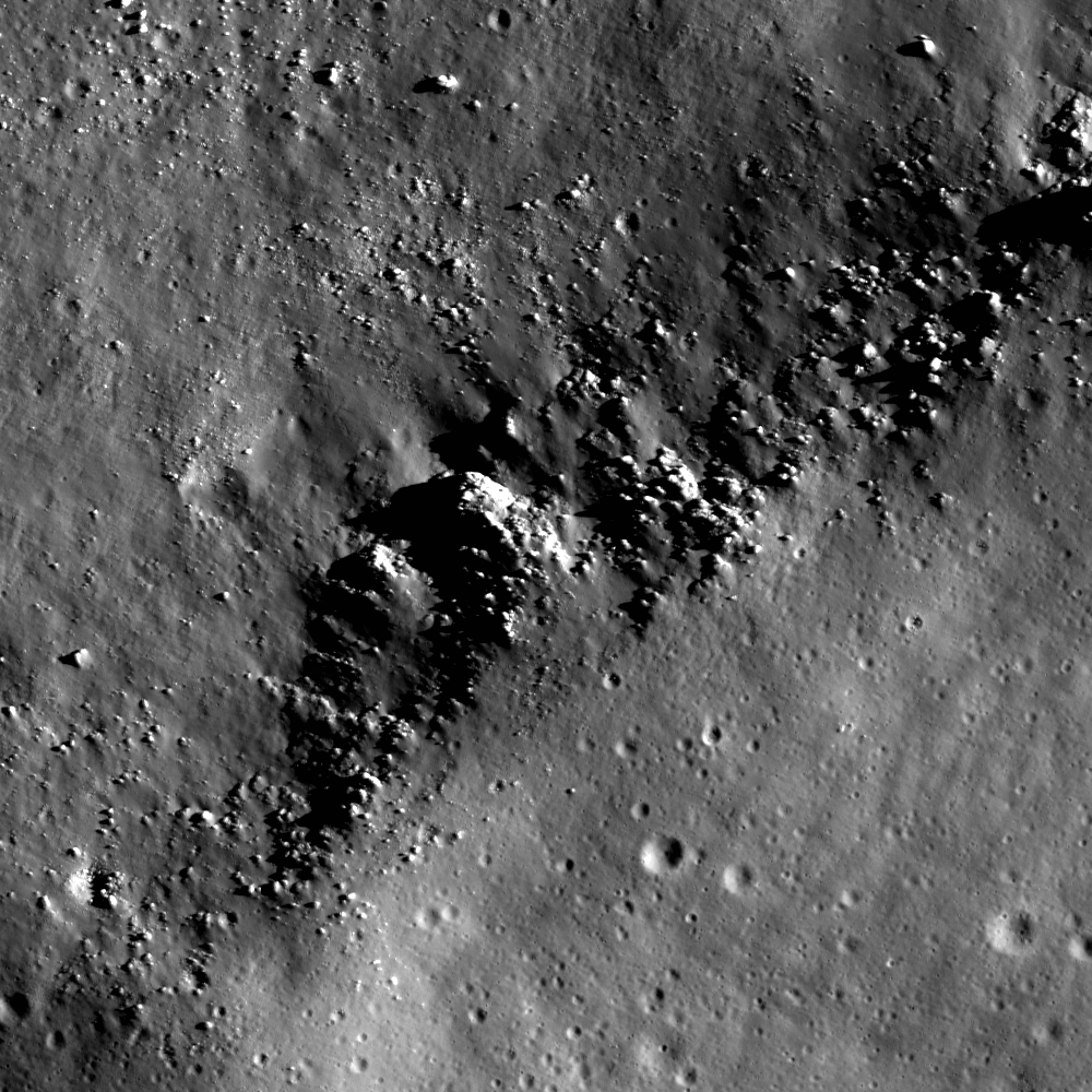
An unnamed crater deformed by tectonic forces. LROC Narrow Angle Camera (NAC) M183760209L, LRO orbit 12175, February 13, 2012; image field of view 960 meters, resolution 0.8 meters. View the more detailed LROC Featured Image HERE [NASA/GSFC/Arizona State University].
Drew Enns
LROC News System

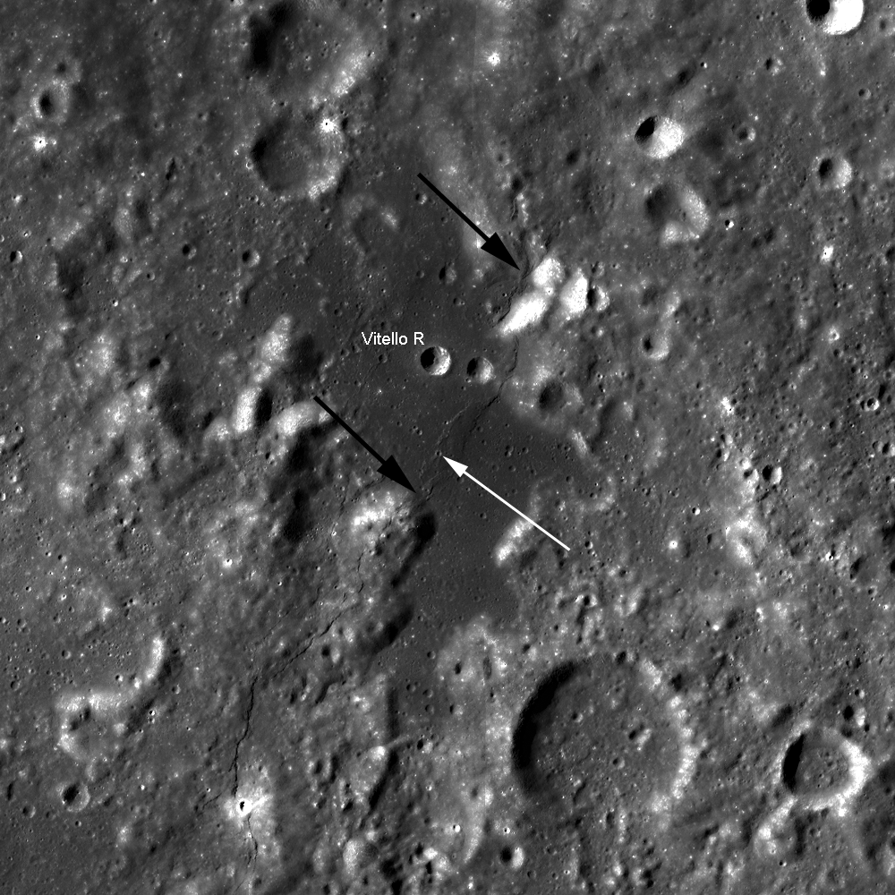
Wrinkle ridges are one of the most common tectonic features on the Moon, and they are found in the lunar maria. Today's Featured Image focuses on one wrinkle ridge, designated Vitello R from the nearby crater, deforming a small mare crater located just south of Mare Humorum. We can tell the wrinkle ridge, and associated tectonic deformation, is much younger than the mare pond as it cross-cuts and modifies the crater (the crater formed after the mare was deposited). Crater counting indicates Mare Humorum is ~3.5 billion years old, but can we say anything more definite about the timing of this wrinkle ridge's formation? Looking at the entirety of the wrinkle ridge may give us more clues.

LROC Wide Angle Camera mosaic as context for the LROC Featured Image released June 8, 2012 (FOV marked with white arrow). The wrinkle ridge can be seen transitioning into a lobate scarp when it exits the mare pond (black arrows). Field of view 58 km across. View the 100 km FOV in image accompanying the Featured Image HERE [NASA/GSFC/Arizona State University].

The wrinkle ridge shows a peculiar change in morphology as it crosses from the mare to the nearby highlands. The wrinkle ridge transitions to a lobate scarp both in the north and south! While wrinkle ridges are characterized by a broad arch with smaller associated ridges, lobate scarps are generally asymmetric landforms with a steep scarp face and shallow tailing end. Both landforms are interpreted as the surface manifestation of thrust faulting in different tectonic settings, so the wrinkle ridge and lobate scarps are probably related. A fresh crater in the bottom-left of the context image erases a portion of the western lobate scarp, but everywhere else the scarp deforms the surface. We can then infer from these observations that the wrinkle ridge-lobate scarp is both caused by a single thrust fault and is fairly young!

Explore more of the wrinkle ridge in the full LROC NAC HERE!

Related Posts:
Not Your Average Scarp
Bulging Wrinkle
Tectonics in Mare Frigoris

Friday, December 31, 2010

More on that second Rupes Recta close-up


Using the Google Earth (>v.5) lunar digital elevation model, after downloading that application's latest catalog of LROC images available through the Planetary Data System (PDS), prepared and updated this past week by Washington University, shows the extent of the only two publicly released LROC Narrow Angle Camera (NAC) observations of "the Straight Wall" of eastern Mare Nubium. Rendered immediately below is a monochrome Wide Angle Camera (WAC) mosaic of the vicinity (stretched, below) that provides a lower resolution but still unprecedented detail of nearby Birt and its ejecta blanket, its companion Birt A and Rima Birt with its "cobra head" feature discussed here July 8, 2010 [NASA/USGS/JAXA/GSFC/Arizona State University/WUSTL/Google Earth].


The 114 km-long landmark "straight wall" with companions Birt and Birt A along the southwest shore of Mare Nubium. With Rima Birt at left, these have often been discussed on the Network. LROC Wide Angle Camera mosaic assembled from images gathered on three successive orbital passes January 7, 2010; processed using LROC WAC Previewer (v.1.6) and stitched together using Microsoft Research Image Composite Editor (ICE) [NASA/GSFC/Arizona State University].

Thursday, December 30, 2010

A second NAC cross-section of Rupes Recta


A year after beginning every-three-month releases of LRO Narrow and Wide Angle Camera observations the latest round December 14 revealed only the second NAC cross-section of the Near Side familiar fault feature Rupes Recta, or "the Straight Wall" seen here very close up from LROC NAC M135236853R, captured during LRO orbit 5063, July 31, 2010. The area has been well-covered by Wide Angle Camera surveys, and there's a lot of material devoted to the subject referenced below [NASA/GSFC/Arizona State University].


A spectacular image from Japan's SELENE-1 ("Kaguya") of Rupes Recta released in 2008, among other new images and data discussed in the post "Rima Birt and Rupes Recta," July 8, 2010 [JAXA/SELENE].

Thursday, July 8, 2010

Rima Birt and Rupes Recta


Cobra's Head of Rima Birt - An uncorrected montage of the left and right frames of LROC Narrow Angle Camera observation M177555153 (Resolution = 67 cm per pixel, from 42.1 km; LRO orbit 2457, January 8, 2010). One of two Lunar Reconnaissance Orbiter Camera (LROC) NAC images in the Second Release to the Planetary Data System that put a new and extraordinary light on a familiar Near Side feature and its surroundings. The observation above, of the cobra head of Rima Birt was imaged in the local evening Sun, only 8 degrees above the western horizon and making the interior of the Rima appear deceptively deep. The distance from the eastern edge of that interior shadow and the feature rim to its east (right) is approximately 800 meters [NASA/GSFC/Arizona State University].

We're grateful to Chuck Wood once again, erstwhile curator of Lunar Picture of the Day (LPOD) for being first to call our attention to the latest, now relatively rare, addition to the Kaguya Image Gallery.

On Wednesday, July 7, under the headline "Wow," Chuck linked to a JAXA MPEG calling it "a remarkable digital flyover of the Straight Wall area" of southeast Mare Nubium.

Though previously available via the JAXA Channel on YouTube, the MPEG rendition of Terrain Camera data gathered by Japan's first lunar orbiter provides better resolution, and it's just as breathtaking.


JAXA (Kaguya/SELENE-1) Terrain Camera and laser altimeter data made possible this virtual view south along the long length of Rupes Recta, part of a remarkable video flyover tour of the area released to the Kaguya Image Gallery, July 5, 2010. The rim of 17km diameter Birt crater rises above the west plain, dominating the southern horizon [JAXA/SELENE].


For scale, the Cobra Head of Rima Birt at the top of this posting can be seen here at center left, in this view from Japan's SELENE-1 lunar orbiter over southwest Mare Nubium. Immediately to east of Rima Birt is 17 km Birt crater, with it's relatively steep slopes supporting Birt A. On the right is the 134 km Rupes Recta, the "Straight Wall." The first HDTV camera to orbit the Moon also flew on Kaguya that swept up more than one outstanding view of the area. Late mission Kaguya HDTV showed the region from progressively lower orbits.

Chuck Wood, author of The Modern Moon: A Personal View (Sky Publishing, 2004), is to be congratulated for reminding us to search through the recent Second Release of LROC images to look for any LRO Narrow Angle Camera close-ups of Rupes Recta, the famous "Straight Wall." A search after the First Release in March turned up nothing, other than preliminary unformatted Wide Angle Camera sessions.

Despite their very real scientific value, their precision and beauty, LROC Wide Angle Camera observations are worth waiting for.

The Rupes Recta region, near the center of the Near Side as seen from Earth, is among the most observed and photographed areas of the Moon. Few are the amateur astronomers on Earth, usually after acquiring their probably more powerful second telescope, who hasn't marveled at their first naked eye view of "Huygens' Sword," or "the Railroad," the 134km long, 490 meter high rift, roughly centered 22.1°S, 352.2°E.


Le Mur droit - An example of the quality of "amateur" photographs of Straight Wall region, as seen from Earth. The area was the subject of "Ancient Thebit and Huygens' Sword," by Charles A. Wood, Sky & Telecope [LPOD/January 11, 2004]..


Our second search of the PDS uncovered two strategically placed LROC Narrow Angle Camera observations, extreme close-ups of noted features, in the vicinity of the Straight Wall (leaving us hungry for more).

Each was gathered in the First Quarter of 2010, and were therefore among those observations in the Second Release of LRO photograpy from LRO announced by LROC principal investigator Marc Robinson, June 21.

One is of the southern half of Rima Birt, and it provided the montage at the top of this post. The cobra head feature can be compared with other less-detailed views of this feature in this post. A second image, viewed in a high sun, has the relief in the long shadows of early morning and late afternoon, slices directly through the Wall's center.


An angled slice through the heart of the Rupes Recta, under a higher Sun (f=33.44° in LRO orbit 3151, March 3, 2010). The 700 meter crater at center predates the rift, and it may have witnessed a gentle transition to its present state. The bright feature on it's eastern interior (see below) is a slide of material once on it's east rim, material originally deep below the progenitor impact's center. Yet another opportunity presents itself for future geologists to take advantage of a ready-made excavation [NASA/GSFC/Arizona State University].

From Lunar Pioneer 4
A closer look at the crater straddling the Straight Wall at 21.6°S, 352.2°E, The character of each half of the plain divided by the rift appears to be similar. Also, at this point in the montage consisting of the right and left frames of LROC NAC M122264663, their overlapping fields of view are joined very close to the location of the rift, so subtle differences in hue might be mistaken for a true appearance [NASA/GSFC/Arizona State University].

Preliminary, low-resolution LRO laser altimetry (LOLA) data clearly picks up the half-kilometer difference in elevations of the plain on either side of Rupes Recta [NASA/GSFC].