 |
| Immediately after sweeping up a splendid oblique view of Reiner Gamma, released previously, September 19, the narrow Rima Galilaei crossed into the LROC NAC view, creating a spectacular Target of Opportunity for the spacecraft and camera. LROC NAC M1127569198R, orbit 18320, July 4, 2013; slew 63° from nadir, averaging 3.9 meters resolution from 110.9 km over 11.85°N, 292.61°E [NASA/GSFC/Arizona State University]. |
Joel Raupe
The holidays and arrival of
Chang'e-3 on the lunar surface delayed a number of posts here, before the New Year. China's first lunar landing and deployment of the Yutu rover at Mare Imbrium, for example, took place as LRO science teams delivered the latest and 16th trimonthly accumulation of data gathered from lunar orbit during three months, from the middle of June to September, last year.
Until today, however, we grievously failed to relay the only known
announcement of the timely release to the Planetary Data System (
PDS) of
LRO observations, made by Ernest Bowman-Cisneros, on behalf of the Lunar Reconnaissance Orbiter Camera (
LROC) team at Arizona State University.
 |
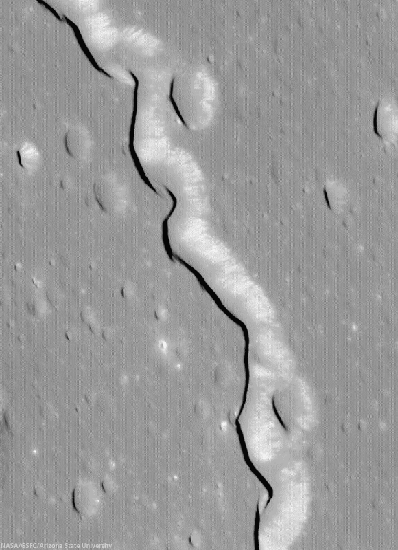
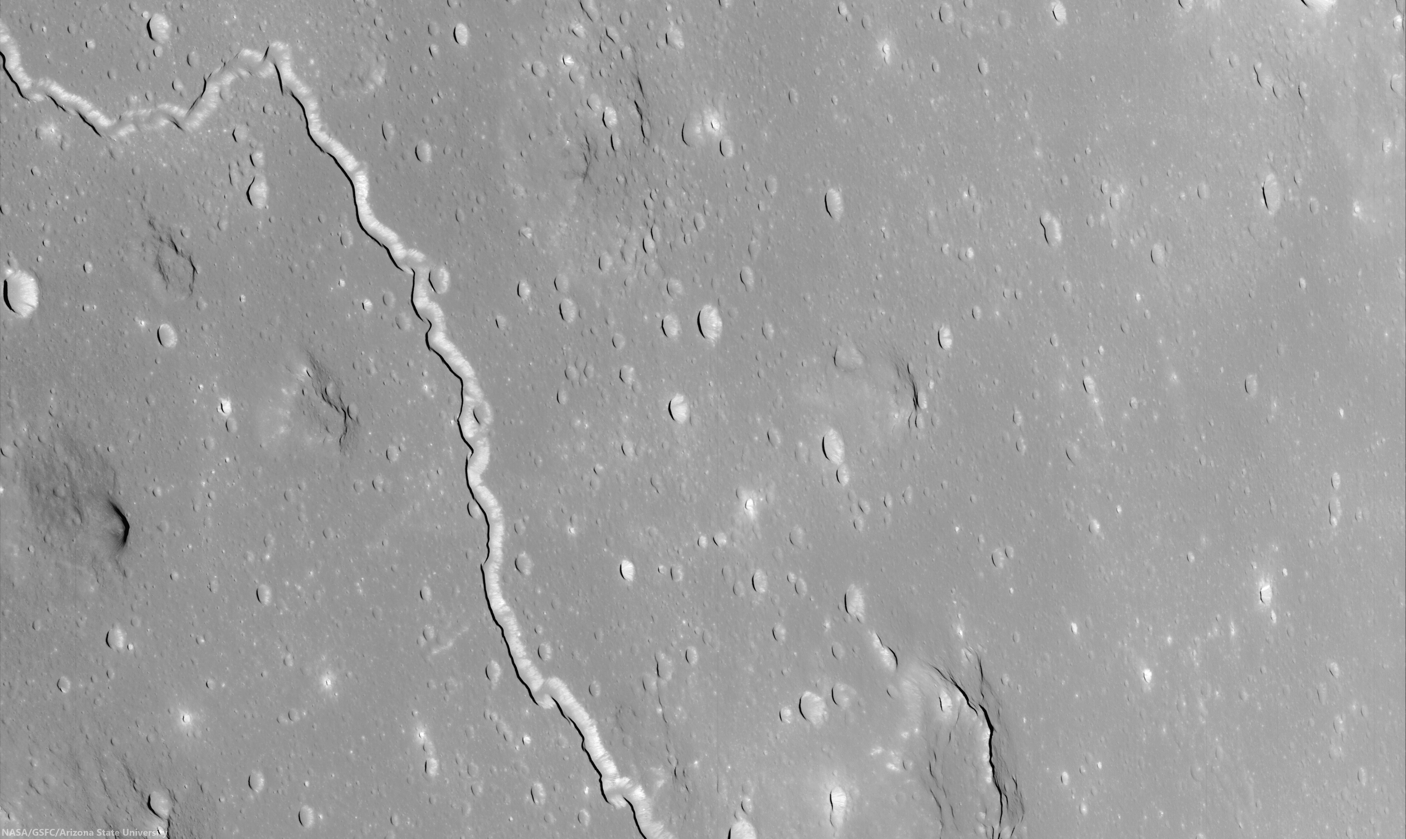
| Rima Galilaei winds 186 km, gradually descending northwest from the Marius Hills, meandering through a relatively featureless expanse of Oceanus Procellarum. The full oblique view above shows a small segment of the sinuous rille with several outlying Marius domes in a roughly corrected mosaic stitched from the entirety of LROC NAC observation M1127569198LR, released December 15. The straight-line distance from where the rille enters and departs this foreshortened field of view is 30 km (full resolution available HERE) [NASA/GSFC/Arizona State University]. |
No one's done a better job cataloging, standardizing, and steadily providing both the science community and public with access to the
incredibly deep
LRO database than Mark Robinson's team at ASU. They don't quite "make it look easy." In fact, their yeoman's efforts tend to conceal the colossal volume LRO has returned from the Moon since June 2009.
Again, coinciding with news of the Chang'e-3 landing, Bowman-Cisneros
wrote, "The 16th LROC Planetary Data System release includes images acquired between June 16 and September 15, 2013.
"This release contains 69,168 EDR images - totaling 7.9 TB, and 69,168 CDR images - totaling 16 TB. An additional 48 NAC Digital Terrain Models (DTMs) and 7 NAC Region Of Interest (ROI) mosaics were also released as part our this LROC RDR volume, rounding out a total 171 NAC DTMs and 100 NAC ROI mosaics released to date."
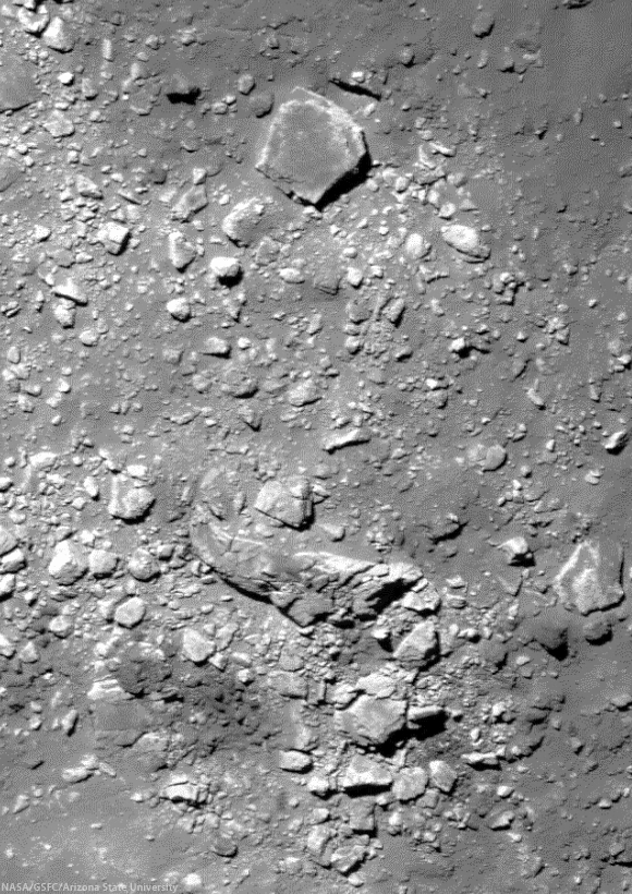 |
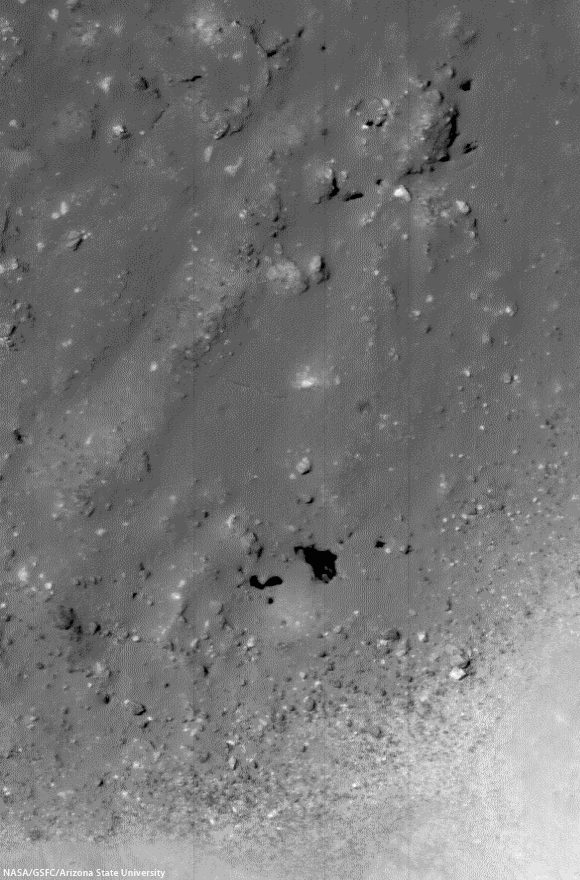
| A 420 meter-wide full-resolution view of massive boulders in a field thrown up by the impact that created the bright crater Brygius A (18.45 km, 24.52°S, 63.81°W). The largest of the boulders in this view (at upper center, and visible as a reference in the wider field below) is about 75 meters across. LROC NAC M1132270283LR, orbit 18981, August 27, 2013; incidence 26.88° and 73 cm per pixel resolution from 69.7 km [NASA/GSFC/Arizona State University]. |
"As of December 15, 2013, EDR and CDR products for Volumes 1-5 were regenerated and released," Bowman-Cisneros announced, as he discussed the housekeeping work, standardizing and streamlining the record-breaking store of high resolution and wide-angle camera orbital images of of the Moon. "Additionally, EDR and CDR products for Volumes 6-12 were also regenerated and will be released by December 20, 2013."
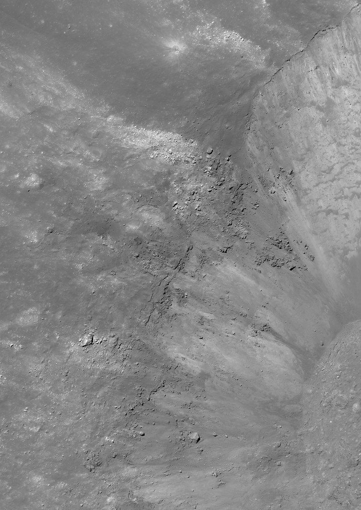 |
| Full-width reduction of a 8925x12618 pixel mosaic showing a 6.5 km wide field of view, context for the rugged boulder field perched on the rim of Byrgius A, shown at full resolution further up. The boulders mark the beginning of one of among many very bright rays that contrast markedly with at least some darker material centered on Byrgius A. LROC NAC M1132270283LR. Wallpaper-aspect version HERE [NASA/GSFC/Arizona State University]. |
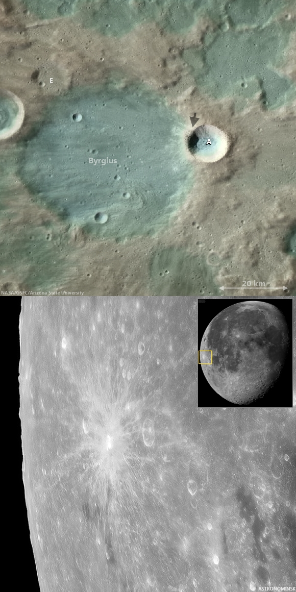 |
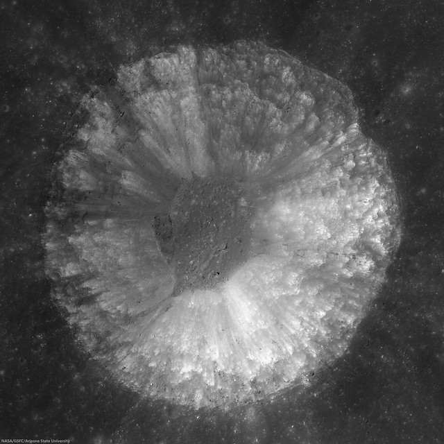
| Bright ejecta of Brygius A obscures its more ancient namesake, whose rim it has excavated. The arrow in the upper image marks the boulder field. Sharp-eyed earthbound observers often spot the brilliant and widespread rays of the younger. much smaller crater with the naked eye. Above: LROC Quickmap at 250 meters resolution, and, Below: inset and full-resolution segment from a truly dramatic mosaic made up of 100 telescopic images of the Waning Moon, September 4, 2012, by Astronominsk (Yuri Goryachko, Mikhail Abgarian, Konstantin Morozov) of Minsk, Belarus. (Hat tips and flowers to Charles Wood and his Lunar Picture of the Day (LPOD).) |
(If this goes on much longer, soon might know as much about our Moon as we do about Mars.)
 |
Apparent pits on the floor of Dollond E (5.22 km, 10.256°N, 15.7°E), a small and relatively fresh crater with a distinctive impact melt pooled. Dollond E is a natural excavation of the Descartes formation in the Southern Highlands, contiguous with the Stone Mountain area explored by Young and Duke of the Apollo 16 expedition and host for one of the Moon's most intense magnetic anomalies. A 400 meter-wide field of view from LROC NAC mosaic M1131744083LR, orbit 18907, August 21, 2013; angle of incidence 21.49° at 70 cm per pixel resolution from 86.47 km [NASA/GSFC/Arizona State University].
|
 |
All of Dollond E, in a reduced, full-width segment from LROC NAC M1131744083LR [NASA/GSFC/Arizona State University].
|
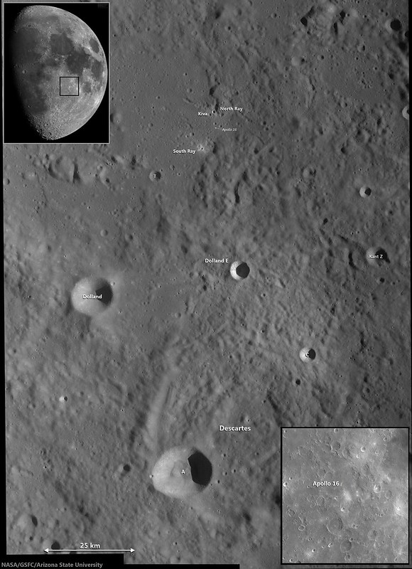 |
| Another juxtaposition of Earth-bound and orbital views centered on Dollond E, with the nearby Apollo 16 landing site and the Descartes formation; context for the LROC NAC study. LROC Wide Angle Camera (WAC) mosaic from three sequential orbital passes in 2011 with telescopic inset by Astronominsk (Moon waxing Full on April 1, 2012) [NASA/GSFC/Arizona State University]. |
A newly-released stash of LROC data is always eagerly received. LRO's record-smashing time in polar orbit around the Moon has allowed nearly all the surface to be photographed at high-resolution, so each new PDS release offers first of a kind views and new angles, resolutions and angles of illumination for other areas. With so much offered, its hard to cast a theme characterizing any single release. As of last summer, the LRO's Extended Science Mission (ESM) has continued from a fuel saving high-side of low lunar orbit, collecting images in the 0.7 to 1.7 meters resolution range. This latest release, on first glance, features fewer dramatic oblique views and more of the kind of "value-added" high-resolution NAC DTM's which will continue to prove this spacecraft's value decades after its mission comes to a end a few years from now.
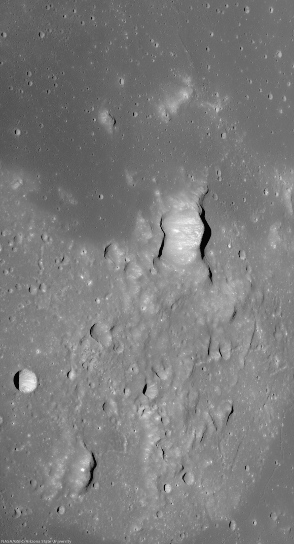 |
| The "Fireman's Helmet," Agartharchides 1, an intrusive volcanic dome, about 60 km across, and a relatively bright telescopic landmark of the southern Oceanus Procellarum. LROC NAC oblique mosaic M1127377730LR, LRO orbit 18292, July 2, 2013; angle of incidence 75.25° looking east with spacecraft and camera slewed 63.4° off nadir. Average resolution about 2.8 meters per pixel from 73.83 km over 16.58°S, 322.78°E. Click image or HERE to view at 40 percent full resolution [NASA/GSFC/Arizona State University]. |


No comments:
Post a Comment