
 |
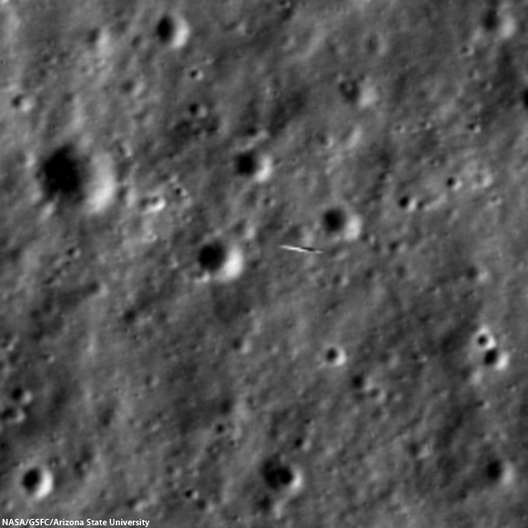
| NASA's Lunar Atmosphere and Dust Environment Explorer (LADEE) caught zooming 9-km below LRO, all the more amazing since the spacecraft orbit the Moon in orbits perpendicularly to one another, or 90° out of phase. LROC NAC M1144387511LR [NASA/GSFC/Arizona State University]. |
Mark Robinson
Principal Investigator
Lunar Reconnaissance Orbiter Camera (LROC)
Arizona State University
Teamwork! Imaging NASA's Lunar Atmosphere and Dust Environment Explorer (LADEE) spacecraft with LROC required extremely precise timing, worked out by the LADEE, LROC, and LRO operations teams. LADEE is in an equatorial orbit (east-to-west) while LRO is in a polar orbit (south-to-north).
By happenstance the two spacecraft are occasionally very close - on 15 January the two came within 9 km of each other. Since LROC is a pushbroom imager, it builds up an image one line at a time, thus catching a target as small and fast as LADEE is tricky! Both spacecraft are orbiting the Moon with velocities near 1600 meters per second (3600 mph), so timing and pointing of LRO needs to be nearly perfect to capture LADEE in an LROC image.
LADEE passed directly beneath the LRO orbit plane a few seconds before LRO crossed the LADEE orbit plane, meaning a straight down LROC image would have just missed LADEE. Now is where the careful planning came into play. The LADEE and LRO teams worked out the solution: simply have LRO roll 34° to the west so the LROC detector (one line) would be in the right place as LADEE passed beneath.
As planned at 8:10:51.693 PM EST on 14 January 2014 LADEE entered the NAC field of view for 1.35 milliseconds and a smeared image of the intrepid spacecraft was snapped. LADEE appears in four lines of the LROC NAC-R, and is distorted right-to-left. What can we see in the LADEE pixels in the NAC image?
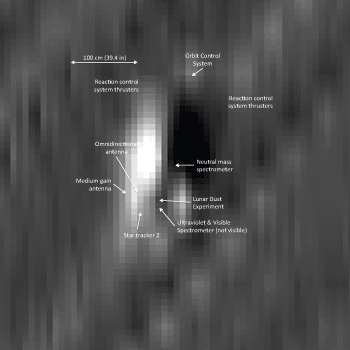
Step one is to minimize the geometric distortion in the smeared lines that show the spacecraft. However, in doing so the background lunar landscape becomes distorted and unrecognizable (see above). The scale (dimension) of the NAC pixels recording LADEE is 9 cm (3.5 in), however, since the spacecraft were both moving about 1600 meters per second the image is blurred in both directions by around 50 cm. So the actual pixel scale lies somewhere between 9 cm and 50 cm, thus even with geometric correction LADEE is a bit blurry. Despite the blur it is possible to find details of the spacecraft, which is about 1 meter wide and 2 meters long. You can see the engine nozzle, bright solar panel, and perhaps a star tracker camera (especially if you have a correctly oriented schematic diagram of LADEE for comparison).
LADEE was designed to study the Moon's thin exosphere and the lunar dust environment. An “exosphere” is an atmosphere that is so thin that molecules do not collide with each other. This exosphere is so tenuous that the number of molecules in a given volume at the Moon is less than the number of molecules in the same volume of space outside the International Space Station..
LADEE is still early in its mission. One of the more exciting moments so far was observing how the lunar exosphere changed as the Chinese lander Chang'e 3 set down on the Moon on 14 December 2013. There was concern that the exhaust plume might spread out and mix with native molecules causing a contamination problem for the LADEE measurements, but so far no problem.
Find LADEE in the NAC left/right mosaic, the irregular shape of the image is due to topography and the off-nadir slew (hint: LADEE coordinates sample 9514, line 19827), HERE.
Related LROC Featured Images:
Impact!
Mountains of the Moon
Principal Investigator
Lunar Reconnaissance Orbiter Camera (LROC)
Arizona State University
Teamwork! Imaging NASA's Lunar Atmosphere and Dust Environment Explorer (LADEE) spacecraft with LROC required extremely precise timing, worked out by the LADEE, LROC, and LRO operations teams. LADEE is in an equatorial orbit (east-to-west) while LRO is in a polar orbit (south-to-north).
By happenstance the two spacecraft are occasionally very close - on 15 January the two came within 9 km of each other. Since LROC is a pushbroom imager, it builds up an image one line at a time, thus catching a target as small and fast as LADEE is tricky! Both spacecraft are orbiting the Moon with velocities near 1600 meters per second (3600 mph), so timing and pointing of LRO needs to be nearly perfect to capture LADEE in an LROC image.
 |
| LADEE smeared out against the lunar background. Image expanded 4x, lunar scene 81 meters wide, LADEE about 2 meters in the long direction [NASA/GSFC/Arizona State University]. |
As planned at 8:10:51.693 PM EST on 14 January 2014 LADEE entered the NAC field of view for 1.35 milliseconds and a smeared image of the intrepid spacecraft was snapped. LADEE appears in four lines of the LROC NAC-R, and is distorted right-to-left. What can we see in the LADEE pixels in the NAC image?
 |
| Geometrically corrected image of LADEE, 4x enlargement[NASA/GSFC/Arizona State University]. |
 |
| Computer generated image of LADEE oriented and illuminated as it was during the close pass with LRO [NASA ARC/LADEE]. |
 |
| Dissolve animation with NAC image of LADEE and labeled LADEE graphic degraded to match NAC resolution [NASA/GSFC/ARC/Arizona State University]. |
Find LADEE in the NAC left/right mosaic, the irregular shape of the image is due to topography and the off-nadir slew (hint: LADEE coordinates sample 9514, line 19827), HERE.
Related LROC Featured Images:
Impact!
Mountains of the Moon
No comments:
Post a Comment