Showing posts with label perilune. Show all posts

Saturday, September 15, 2012

Corrected close-ups

An oblong boulder left its distinctive impression on the gentle slope of a small crater near the center of Mare Serenitatis (24.64825°N, 18.85852°W). LRO was only 23 km above the Moon's nearside surface when this 31 cm resolution image was captured; LROC NAC M168081909R  orbit 9904, August 15, 2011. Angle of incidence 46.75° [NASA/GSFC/Arizona State University].
Nearly a year has gone by since the record-smashing Lunar Reconnaissance Orbiter had its orbital periapsis reduced dramatically, ahead of having its orbit brought up to a longer duration polar orbit above 100 km. In that time the LROC team at Arizona State University captured a catalog of dramatic close-ups, among these quick surveys of most of the Apollo landing sites of unprecedented clarity. Quite a number of pictures of less interest to the general public were captured as well, as LRO swept down over the Moon's nearside barely 20 km overhead.

Though the Clementine platform and the optically blind Lunar Prospector both completed their missions before the close of the last century (and the Apollo surface experiments were switched off in 1977) new research based on data collected from those efforts still regularly appears in the science journals. It's reasonable to expect new breakthroughs will continue to appear long after the LRO mission is completed, as well.

We are still threading through thousands of LROC Narrow Angle Camera close-ups from late in the summer of 2011, teasing images out while accounting for the distortions in the raw data that arise from the higher-speed with which LRO encountered its surface targets during those low passes.

In appearance much like driveway gravel, these boulders at the bottom of the cobra-head formation of a prominent sinuous rille in the Vera-Prinz region of Oceanus Procellarum would dwarf most houses. By far, the largest of the boulders (26.3353°N, 43.71077°W), isolated at upper right, is 28 meters wide. Full 41 cm resolution mosaic of LROC NAC frames M168488930L spacecraft orbit 9964, August 20, 2011; angle of incidence 43.79° from 26.43 km [NASA/GSFC/Arizona State University].
Belated corrections - Like the Moon, like the geological rate of change in the data in those vast catalogs, many of the posts appearing here have staying power!

Because of a busy season near the end of 2011, not long after the first bulk publication of many of these dramatic close-ups, in the LROC Planetary Data System release of December 15, 2011, we grabbed a quick look at a few of them and failed to return afterward to properly re-sample them.

Even backed away and resampled to 4 meters resolution, revealing the boulder field's location on the floor of the Vera formation (26.32°N, 316.28°E), the cobra head of a sinuous rille in Oceanus Procellarum, the level of detail visible in this LROC NAC frame is remarkable [NASA/GSFC/Arizona State University].
Uncorrected, these images first appeared here in a series of posts in late December, and having had the error pointed out nine months later, right about the time of our 3000th post since 2006, perhaps we can find time over the course of the remainder of our lives to correct all the other embarrassing errors also.

Life is short, but the "inconstant Moon" is just about eternal.

Context is nearly a necessity when presenting LROC NAC derivative imagery. Vera is demonstrated in this simulated perspective from NASA's ILIADS application to be more than merely the cobra-head of a sinuous rille. It appears to be a cobra-head within a cobra-head, emerging as many similar formation on the Moon do, from beyond the rim of a crater that, at some point after its formation, was inundated by fresh melt. Another example is Plato. Perhaps Prinz, now a nearly buried ghost crater, was flooded twice [NASA/GSFC/LMMP/Arizona State University].

Friday, July 27, 2012

"O! say can you see by the dawn's early light..."

LROC's most frequently asked question answered:LRO slewed 19° down-Sun allowing the illuminated side of the still standing American flag to be captured at the Apollo 17 landing site. LROC Narrow Angle Camera (NAC) observation M113751661L, LRO orbit 1897, November 25, 2009; 52.5 cm resolution, angle of incidence 56.73° from 44.87 kilometers [NASA/GSFC/Arizona State University].
Mark Robinson
Principal Investigator
Lunar Reconnaissance Orbiter Camera
Arizona State University
 

The most common questions to the LROC team before launch concerned what will we see at the Apollo sites? Will we see the Lunar Module descent stage and rovers? What about rover tracks, or the American flags? As we now know, the NAC images clearly show all of the above items (see links to earlier posts at the bottom). Personally I was a bit surprised that the flags survived the harsh ultraviolet light and temperatures of the lunar surface, but they did.

What they look like is another question (badly faded?). Much has been written about the Apollo flags, a comprehensive summary is available at the Apollo Lunar Surface Journal.

Charlie Duke captures John Young saluting the flag while jumping, (twice). A great demonstration of the lower gravity on the Moon. Apollo 16 Lunar Module (LM) Orion and the Lunar Roving Vehicle (LRV) are in the background. View the re-master original indexed at the Apollo 16 Lunar Surface Journal, HERE - MET: 120:25:42 - (AS17-113-18339) "He is off the ground about 1.45 seconds which, in the lunar gravity field, means that he launched himself at a velocity of about 1.17 m/s and reached a maximum height of 0.42 m. Although the suit and backpack weigh as much as he does, his total weight is only about 65 pounds (30 kg) and, to get this height, he only had to bend his knees slightly and then push up with his legs." Video Clip ( 3 min 21 sec 0.9 Mb RealVideo or 30 Mb MPEG ) [NASA].
The opening image was taken early in the mission, and is one of the best views of the American flag because the spacecraft was pointed towards the illuminated side of the flag, and Sun was low enough (56° incidence angle) such that distinct shadows were cast.

The flag was captured in this image of the Apollo 16 site with the spacecraft slewed 15° towards the Sun; the shadowed side of the flag is seen by LROC. NAC frame M175179080L, orbit 10950, November 6, 2011; native resolution 40.4 cm per pixel, angle of incidence 41.91° from 23.56 kilometers [NASA/GSFC/Arizona State University].

From the LROC images it is now certain that the American flags are still standing and casting shadows at all of the sites, except Apollo 11. Astronaut Buzz Aldrin reported that the flag was blown over by the exhaust from the ascent engine during liftoff of Apollo 11, and it looks like he was correct! The most convincing way to see that the flags are still there, is to view a time series of LROC images taken at different times of day, and watch the shadow circle the flag (see movie below; the flag is just above the LM descent stage).


Visit the full resolution NAC of the Apollo 16 site HERE. A full resolution version of the Apollo 12 time series is available HERE.

Explore all the Apollo sites on LROC's new Featured Sites webpage!

Related Posts:
Exploring the Apollo 17 Site
Apollo 11 Low Altitude
Apollo 12 Low Altitude
Apollo 14 Low Altitude
Apollo 15 Low Altitude
Apollo 16 Low Altitude North Ray Crater
Apollo 17 Low Altitude
Apollo 17 Low Altitude Shorty Crater

Friday, March 9, 2012

LROC: How Young is Young? (Apollo 16)

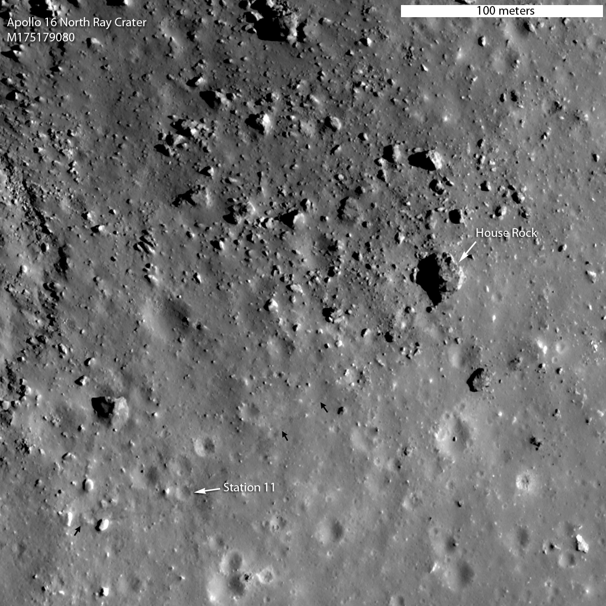
Area on the southeastern rim of North Ray crater explored by Apollo 16 astronauts John Young and Charlie Duke, revealed in striking resolution in recent low altitude LROC Narrow Angle Camera (NAC) mosaic M175179080NR, orbit 10,950, November 6, 2011. The above detail from the field of view in the release is 300 meters wide, (small arrows show the foot tracks of Young & Duke left behind during their traverse from the rover, to and from House Rock. View the full size Featured Image HERE. (Compare this image with John Young's picture of Home Rock taken from Stone Mountain in 1972 at the end of this post) [NASA/GSFC/Arizona State University].
Mark Robinson
Principal Investigator
Lunar Reconnaissance orbiter Camera
Arizona State University

One of the main goals of the Apollo 16 mission was to explore and sample a young bright rayed crater aptly named North Ray crater (890 m diameter). Its high albedo is due to its young age. During an impact event geologic material from depth is excavated and spread around a crater. The deepest material ends up near the rim, and the shallower material is thrown out farther. The pre-existing surface was mature, meaning that its albedo was diminished over time due to solar wind and micrometeorite bombardment (space weathering).

The fresh material from depth had not suffered these effects, thus its high albedo. If you wait, you can observe the North Ray crater's albedo decrease over time - but you would have to be very patient, since this space weathering process takes hundreds of millions of years to complete. At the time of the Apollo 16 mission scientists did not know the age of North Ray crater, nor did they know as much as we know today about the details of the space weathering process, so an important goal was to learn what young really means on the Moon.

North and South Ray craters are familiar companions in the southern nearside lunar Highlands in earthbound telescopes, making it unusually easy to spot the landing site of Apollo 16, at least in the mind's eye, situated directly between them. This detail is from a large November 6, 2011 mosaic put together by Yuri Goryachko, Mikhail Abgarian, Konstantin and Konstantin Morozov of Astronominsk, in Minsk, Belarus [Astronominsk].
From 400,000 to a mere 43 kilometers away, an LROC Wide Angle Camera (WAC) monochrome (643 nm) mosaic of North and South Ray craters, and the landing site of Apollo 16, April 21, 1972; LRO orbits 6778 and 6779, December 13, 2010, incidence angle 74.6° with a resolution of 60 meters from 43 kilometers [NASA/GSFC/Arizona State University].
Apollo 16 traverse map, overlain on Apollo
metric camera mosaic in Google Earth. View the
map accompanying the Featured Image HERE.
North Ray crater, which is almost 250 m deep, was the largest and deepest crater visited during the Apollo 16 mission, and its rim was the stop known as Station 11, visited on the third and final EVA. Because the rim sloped off gradually into the crater, and the crater was so deep (relative to its diameter), the astronauts could not actually see the bottom of the crater while standing on its rim.

It was hoped by pre-mission planners that the astronauts would look into the crater and see discrete layers of highlands volcanic rocks.

When John Young and Charlie Duke actually got to North Ray, the astronauts saw no evidence for lava layering in its walls. Rather, the samples they collected from the rim were almost all impact breccias, or rocks formed from the pieces of other rocks during a much larger impact event.

Since the crater is so deep, it excavated long-buried lithologies, so sampling North Ray rim materials provided important information about the geology of the Apollo 16 site.

The samples from the rim of North Ray almost certainly included material from the Descartes formation, one of two major geologic units at the Apollo 16 landing site.

John Young geologizing on the rim of North Ray crater.
Their next destination will be House Rock, seen behind
Young, above his right shoulder, AS16-106-17336 [NASA].
A particularly important sampling location on the rim of North Ray crater was dubbed “House Rock”, so-named because it appeared to be the size of a house to the astronauts. 

As it turns out this house sized rock is actually 24 meters by 20 meters (79 by 65 feet)! A smaller rock (9 meters or 30 feet) directly to the south was dubbed “Outhouse Rock”, and several samples were collected at this location. 


The samples collected on the rim of North Ray crater, including those from House Rock, represent our best look at the lunar highlands and the awesome process of basin ejecta emplacement. The breccias that were sampled by Young and Duke were all formed as massive flows of rock that traveled across the Moon's surface as result of the formation of the Imbrium basin and the Nectaris basin. The formation of North Ray crater brought breccias up from depths greater than 200 meters, allowing Young and Duke to sample a three-dimensional section of the local stratigraphy.

From these samples we now know that the region is not formed of unusual lavas, but rather basin ejecta. Now believed to represent materials that were excavated from near the bottom of North Ray crater, both of these rocks originally formed as part of giant impact breccias. Age-dating these samples back on Earth revealed that the materials that comprise House and Outhouse rocks formed about 3.9 billion years ago, although the North Ray impact that excavated House Rock itself occurred only about 50 million years ago. So we now know the age of formation of the massive ejecta flows, and we have an answer to how young is young: the age of the youthful North Ray crater is an important point on our absolute age scale of lunar events.

Charlie Duke samples a shatter cone formation in Outhouse Rock, a large fragment shed off the southern end of House Rock during the third and final EVA of Apollo 16. Note the accumulation of lunar dust after totaling 20 hours on the lunar surface. AS16-116-18649 [John Young/NASA/JSC/ALSJ].
Geologists mapped out two major units in the area: the Cayley formation, which lies on top of the Descartes formation (remember what lies on top is younger). Tentatively, the Cayley formation is interpreted to have formed as ejecta from the Imbrium basin, while the Descartes formation is thought to represent ejecta from the older Nectaris basin. Since rim samples of North Ray crater likely came from the bottom of the crater, scientists believe they represent the stratigraphically lower Descartes formation (Nectaris ejecta).

In general, the age-dating of the breccias collected on the rim of North Ray crater is currently considered to provide the best available estimate for the formation age of Nectaris basin (estimates range from 3.85 to 3.92 billion years ago), an important anchor for lunar stratigraphy.

LROC NAC stereo derived topography of North Ray crater. View the full-sized LROC context image HERE [NASA/GSFC/
Arizona State University].
Up to two times a day the LROC NAC obtains stereo pairs of key science targets, including the Apollo 16 site. The stereo images provide the means to make detailed topographic maps, a powerful tool for unraveling the local geology and planning future missions to the Moon (robotic and crewed). If Young and Duke had the above LROC topographic map, they might have planned a traverse part way into the crater, or perhaps all the way to the bottom!

Inspect the whole of North Ray crater at 25 centimeter pixel scale, HERE. Note the faint and bright rover tracks indicated with small white arrows, small black arrows point to astronaut tracks.

Previous Low Altitude LROC Image Releases: Apollo 11, Apollo 12, Apollo 14, Apollo 15, Apollo 17

And just for fun: perspectives of North Ray crater made with NAC images and NAC topography at one-to-one vertical to horizontal scale (natural perspective). See if you can spot House Rock by comparing to the full resolution image map. Enjoy!

North to south perspective across North Ray crater. View the original HERE [NASA/GSFC/Arizona State University].
South to north perspective view of North Ray crater from close range, View the original HERE [NASA/GSFC/Arizona State University].
South to north perspective view of North Ray crater from far range. View the original HERE [NASA/GSFC/Arizona State University].
Looking north, 500mm high-resolution detail from AS16-108-17612 by John Young, taken from the heights of Station 4 on Stone Mountain across the Cayley plain toward the rim of North Ray crater. The Lunar Module Orion can be seen at lower left and at upper right, nearly twice as distant, is House Rock. Young and Duke would visit there the following day [NASA/GSFC/Arizona State University].

Thursday, March 8, 2012

LROC's Closest look yet at Tranquillity Base

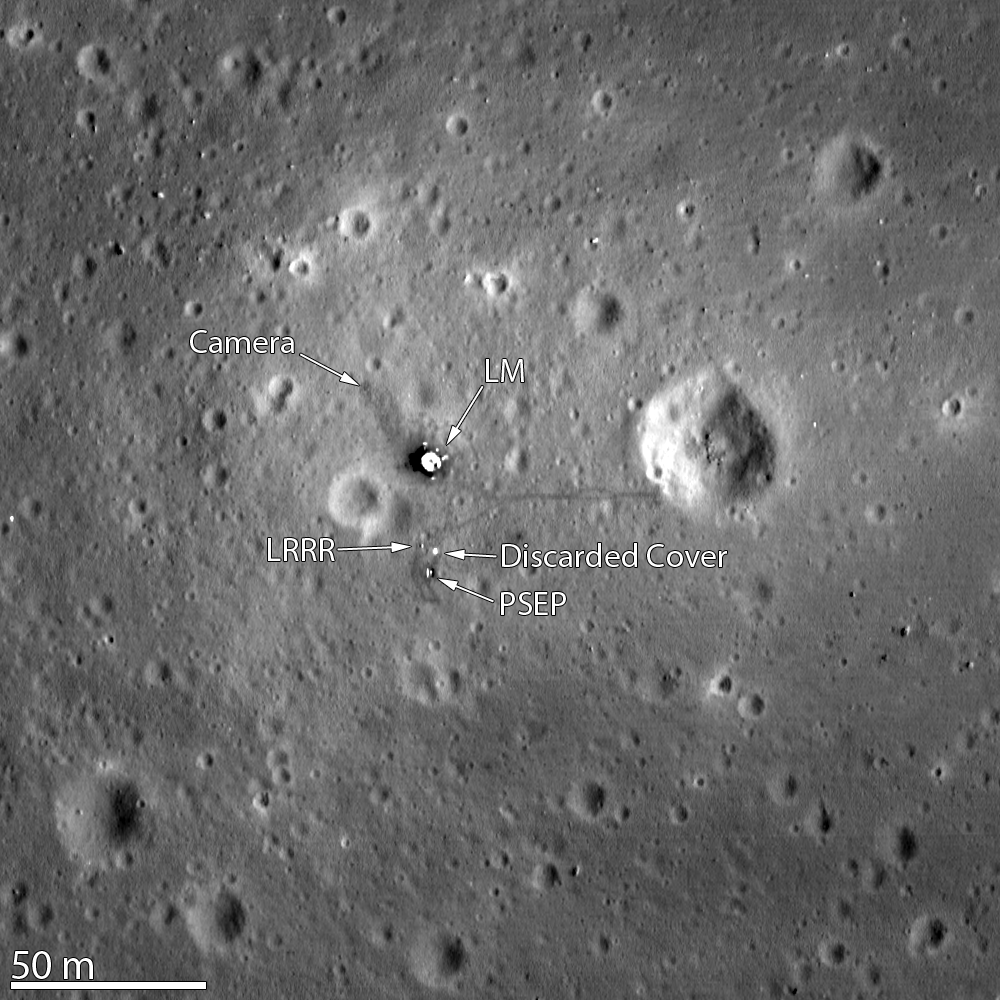
A Stark Beauty All Its Own, Apollo 11 from low altitude (~25km altitude), LROC's best look yet at the July 20, 1969 landing site (0.672°N, 23.483°E) in the southwestern corner of Mare Tranquillitatis - Remnants of Armstrong & Aldrin's historic first steps on the surface are clearly visible in darker paths around the Lunar Module Eagle Descent Stage, Lunar Ranging RetroReflector (LRRR) and Passive Seismic Experiment Package (PSEP) and Aldrin's short path behind the lander to the rim of Little West crater. LROC Narrow Angle Camera (NAC) observation M175124932R, LRO orbit 10,942, November 5, 2011; resolution 25 centimeters per pixel. View the wider field of view in the LROC Featured Image HERE  [NASA/GSFC/Arizona State University].
Mark Robinson
Principal Investigator
Lunar Reconnaissance Orbiter Camera (LROC)
Arizona State University

This image of the Apollo 11 landing site captured from just 24 km (15 miles) above the surface provides LRO's best look yet at humanity’s first venture to another world. When Neil Armstrong took his famous first steps onto the lunar surface, he kicked around the soil. “Yes, the surface is fine and powdery.” Gazing at the flat horizon, he took in the view. “Isn’t that something! Magnificent sight out here.” After collecting a contingency sample Neil looked around and observed, "it has a stark beauty all its own. It's like much of the high desert of the United States. It's different, but it's very pretty out here." A few minutes later Buzz Aldrin descended the ladder and joined Neil on the surface of the Moon!

You can see the remnants of their first steps as dark regions around the Lunar Module (LM) and in dark tracks that lead to the scientific experiments the astronauts set up on the surface. The Passive Seismic Experiment Package (PSEP) provided the first lunar seismic data, returning data for three weeks after the astronauts left, and the Laser Ranging RetroReflector (LRRR) allows precise measurements to be collected to this day. You can even spot the discarded cover of the LRRR.

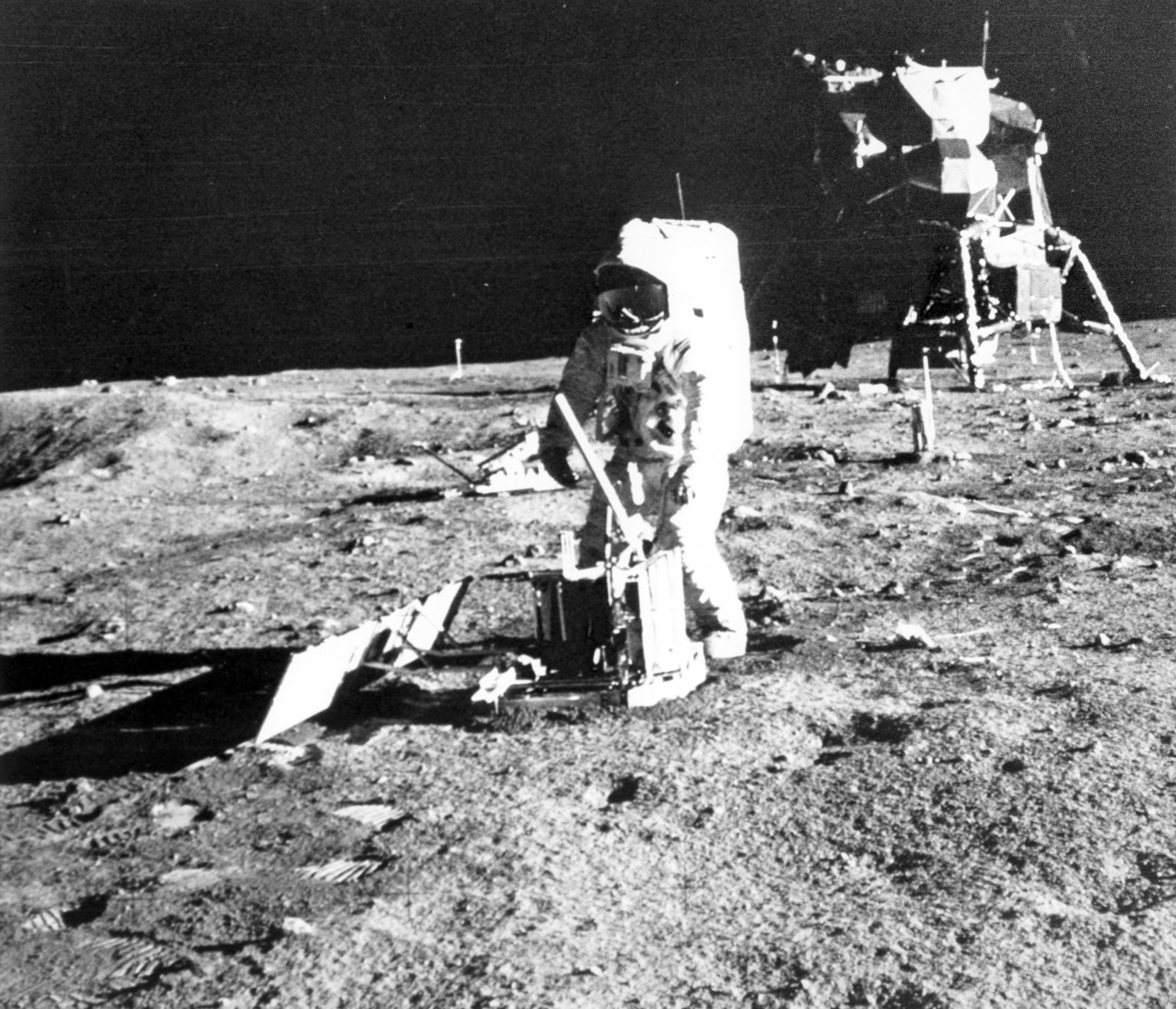
Aldrin deploys the solar array of the Passive Seismic Experiment Package (PSEP) at Mission Elapsed Time (MET) 111 hours, 6 minutes and 40 seconds, July 20, 1969. Behind him are other items noted in the LROC orbital close-up imaged 42 years later, including the lunar ranging retro-reflector (LRRR), Discarded Cover and television camera (AS11-40-5947) [Neil Armstrong/NASA JSC/ ALSJ].
Another trail leads toward Little West crater around 50 meters (164 feet) to the east of the LM. This was an unplanned excursion near the end of the two and a half hours spent on the surface. Armstrong ran over to get a look inside the crater, and this was the farthest either astronaut ventured from the landing site. Compared to Apollo 12 and 14, which allowed for more time on the surface, and Apollo 15, 16, and 17, which had the benefit of a Lunar Roving Vehicle, Armstrong and Aldrin's surface activities were quite restricted. Their tracks cover less area than a typical city block!

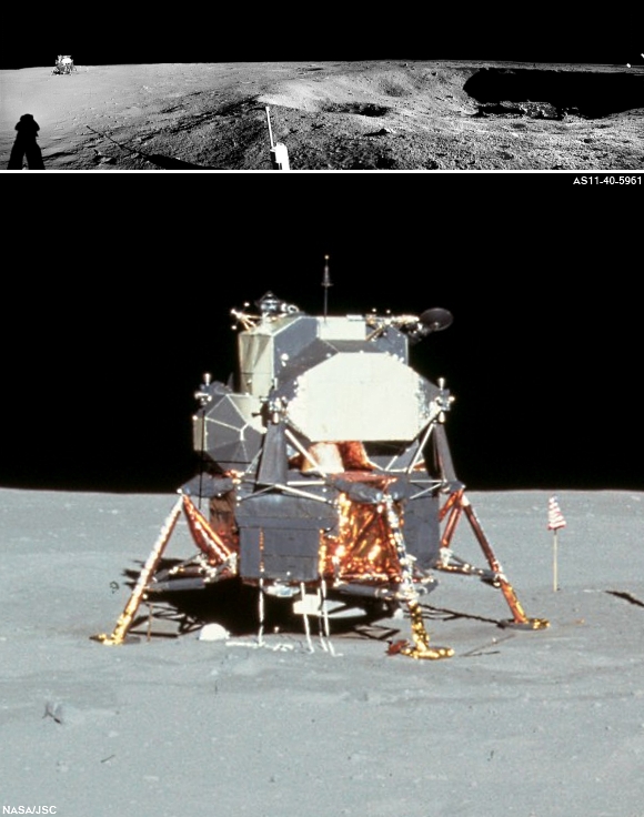
Full resolution detail from AS11-40-5961, part of a lunar surface "early-morning" down-sun panorama stitched from a series of photographs taken from the rim of Little West crater (MET 111:11:31). A very short Moon walk, the The entire area covered by Armstrong & Aldrin would fit in a standard basketball court [Neil Armstrong/NASA/ALSJ].
Not only was the landscape a place of "stark beauty", but also the source of rocks that revealed the Moon’s fiery past for the first time. The samples showed that the Apollo 11 landing site in Mare Tranquillitatis was once the site of volcanic activity, and the flat surface that afforded such an incredible vista was due to broad, thin flows of lava that flooded the region.

Check out past views of the Apollo 11 site at lower resolution (but complementary illumination angles):


Browse the full resolution NAC image HERE.

Monday, December 26, 2011

LROC: Aristarchus Spectacular!

West wall of Aristarchus crater seen obliquely by the LROC Narrow Angle Cameras from an altitude of only 26 kilometers. Scene is about 12 kilometers wide at the base, NAC observation M175569775, LRO orbit 11008, November 10, 2011. View the full resolution west wall panoramic image HERE  [NASA/GSFC/Arizona State University].
Mark Robinson
Principal Investigator
Lunar Reconnaissance Orbiter Camera
Arizona State University


The Aristarchus plateau is one of the most geologically diverse places on the Moon: a mysterious raised flat plateau, a giant rille carved by enormous outpourings of lava, fields of explosive volcanic ash, and all surrounded by massive flood basalts. A relatively recent asteroid (or comet) slammed into this geologic wonderland, blowing a giant hole in the ground revealing a cross section of over 3000 meters (9800 ft) of geology. No wonder planners for the Apollo missions put this plateau high on its list of targets for human exploration. This amazing image was acquired on 10 November 2011 as LRO passed north-to-south about 70 km east of the crater's center while it was slewed 70° to the west. The spacecraft was only 26 km (16.2 miles) above the surface; about two times lower than normal. For a sense of scale, that altitude is only a little over twice as high as a commercial jets fly above the Earth!

Full panoramic view of the west wall of Aristarchus crater revealing impact melt deposits, exposures of high reflectance, anorthosite, streamers of pyroclastic ash and blocks up to 100 meters in size. Full width of panorama is about 25 km, M175569775 [NASA/GSFC/Arizona State University].
Aristarchus crater is located on the southeast edge of the Aristarchus Plateau. This gaping crater is 40 km wide and 3.5 km deep. The ledges forming the wall of the crater, which look a lot like those of a strip mine, are actually blocks of pre-impact crustal and surficial rocks that slumped into the crater during the late stages of its formation. The impact that formed this crater occurred on a mare-highland boundary and thus excavates a variety of rock types.

The LROC NAC footprint for observation M168516102, from which the following six oblique views were cropped, all of them from the right frame and spotlighting areas within the northwest rim of bright Aristarchus. The view above simulates an oblique view of the area, most if which is also found within the LROC Featured Image released December 25, 2011, from a point well south of Aristarchus Plateau 25 kilometers in altitude [NASA/GSFC/Arizona State University].
 
Six sections, reluctantly reduced from their original 40 centimeter-per-pixel resolution, lifted from LROC Narrow Angle Camera observation M168516102R, LRO orbit 9968, August 20, 2011 (when the LRO orbit was briefly lowered to an average 25 kilometer high perilune, are unparalleled examples of the west-northwestern Aristarchus crater wall's variety of textures. Solar illumination incidence angle was 42.43° centered on 24.36°N, 312.18°E from 25.05 km altitude [NASA/GSFC/Arizona State University].
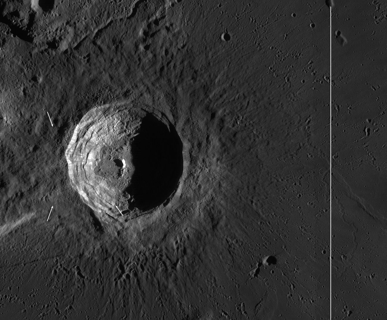
Dawn View of Aristarchus: Sunrise lighting enhances surface texture on Aristarchus crater (40 km diameter). Northwest (upper left) of the crater is the mysterious Aristarchus plateau, to the east, southeast, and south lies the edge of the vast mare Oceanus Procellarum. Small white arrows indicate approximate corners of the NAC panorama, In the full size LROC context image, a vertical line on the right shows the LRO orbit ground track when the Featured Image NAC panorama was acquired. (LROC WAC mosaic) [NASA/GSFC/Arizona State University].
The ledges forming the crater wall, which have a scalloped appearance, are sagging blocks of the pre-impact lunar crust. Bright and dark materials are exposed in patches along the walls. Dark streaks of impact melt and debris cover some of these materials (dark region from top-to-bottom just left of center). Pyroclastic beads (volcanic glasses formed during fire-fountain style eruptions similar to those of Stromboli or the Hawaiian Islands) that blanket the area around the crater have slid down parts of the walls in dark streaks and clumps (visible as small dark streamers across the top of the crater in the center of the panorama). These pyroclastic deposits represent one of the largest, most accessible exploration-enabling resource deposits on the nearside of the Moon. Despite the blanket of dark glassy materials, Aristarchus crater is still one of the most highly reflective areas on the Moon. Much of this high reflectance is due to the excavation of rocks from deep in the crust. These deep rocks may be anorthositic like the highlands, or they may be a more silicic rock like granite (or both). Although granites have been found in Apollo rock samples, the formation of granite on the Moon is not well understood at this time - another reason why we need to get samples from this region!

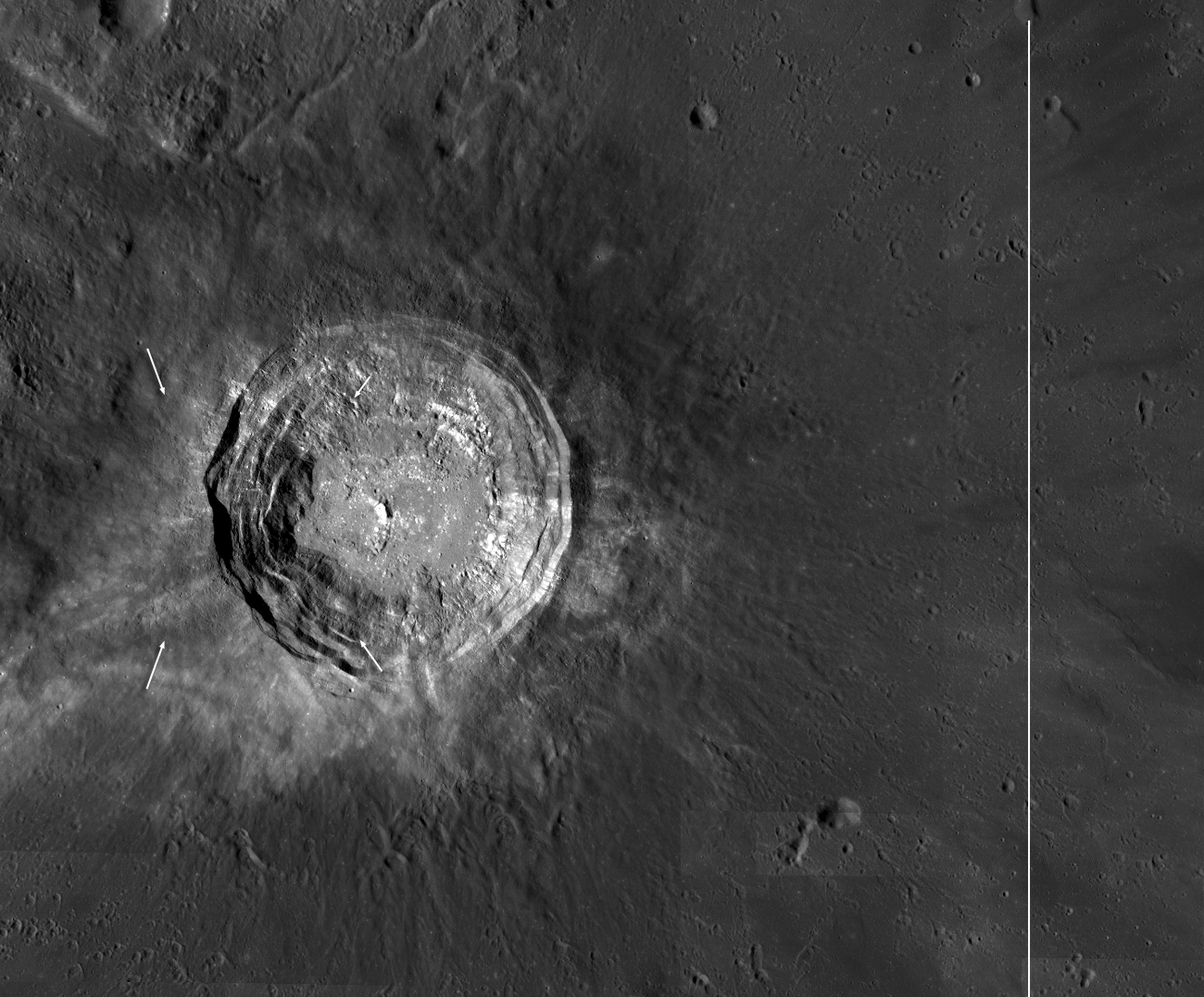
Early afternoon Aristarchus: Early afternoon WAC mosaic of Aristarchus crater to compare with the sunrise mosaic above. Again, small white arrows indicate the approximate corners of the Featured Image NAC panorama, and in the original context image a vertical line on the right (beyond the field of view of this crop from the original) shows LRO orbit ground track [NASA/GSFC/Arizona State University].
Look closely at the early afternoon lighting WAC mosaic; you can clearly see that some of the Aristarchus ejecta has high reflectance, and some has low reflectance. This contrast reflects the compositional difference between the target rock. The northwest portion was mostly basalt and ash, while the south-southeast was predominantly crustal rocks (anorthosite and/or granite).

The floor of Aristarchus crater provides explorers a unique opportunity to study a wide variety of lunar rocks and geologic processes, possibly including how lunar granite forms. Diverse materials such as dark, multilayered mare basalts in the walls, bright crustal rocks in the central peak, impact melt, and even regional pyroclastic materials blanketing the crater are brought to the floor and accumulated through mass wasting, creating a bountiful trove of
geologic materials.

Jump to the full resolution west wall panoramic image, and view our flyover video on Youtube.


Previous LROC Aristarchus Featured Images:
Geologic Diversity of the Aristarchus Plateau
Striated Blocks in Aristarchus Crater
Aristarchus Plateau Pyroclastics
Central peak of Aristarchus (with fly-over)