 |
| A striking young Moon, only 2.35 days past New, only 5.5 percent illuminated by the Sun, the remainder in earthshine, brought out with exceptional artful detail. The target was 399,215 km away and slowing as its approaches perigee at roughly a kilometers per minute [Maurice Collins/Moon Science]. |

Showing posts with label Maurice Collins. Show all posts
Showing posts with label Maurice Collins. Show all posts
Saturday, August 10, 2013
Earthshine


Monday, March 4, 2013
New oblique views of Gruithuisen Domes
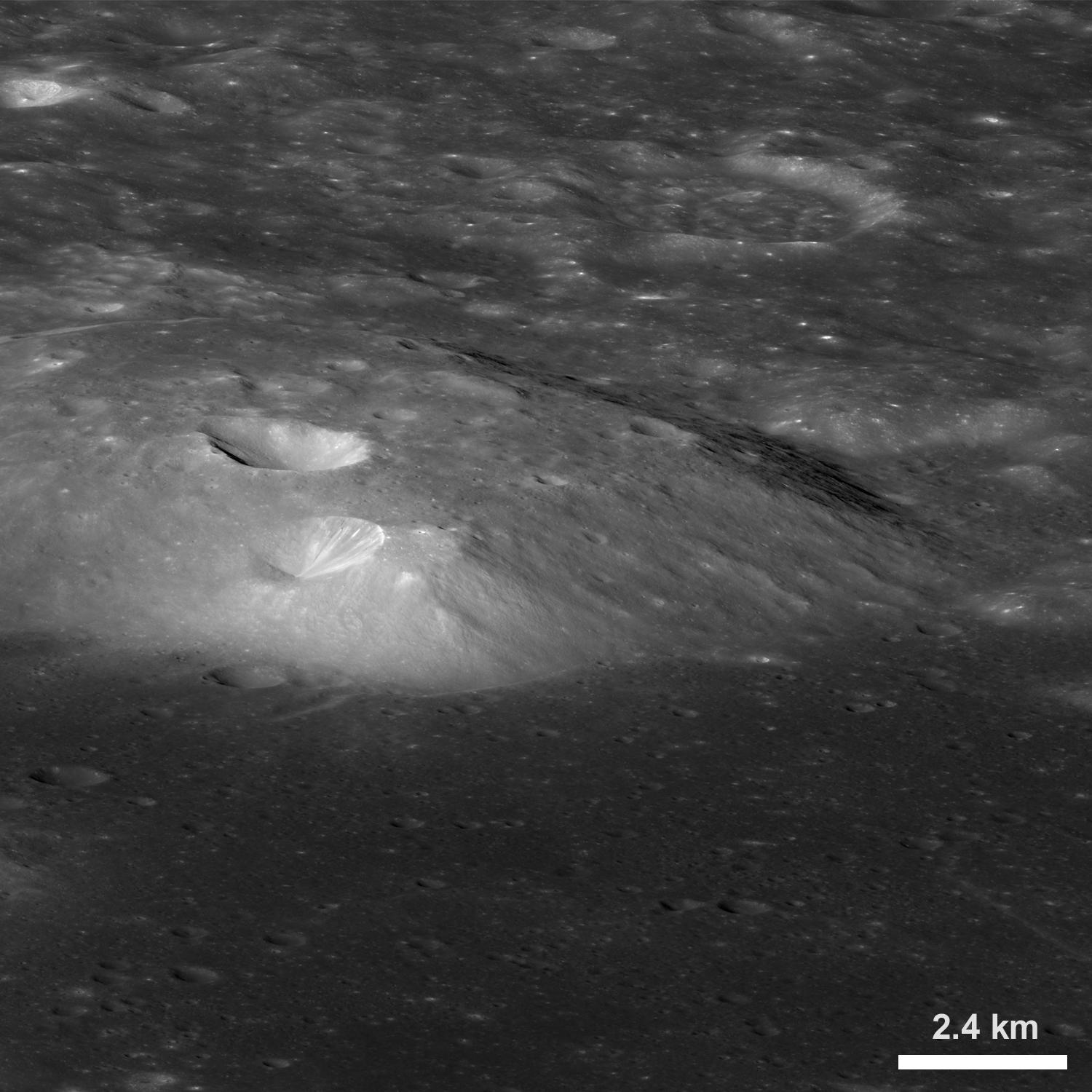 |
| An oblique view of the northern portion of the Gruithuisen Gamma volcanic dome, from the northwest. From a new LROC Narrow Angle Camera (NAC) mosaic M1106087898LR, LRO orbit 15300, October 28, 2012; overall resolution 4.9 meters per pixel [NASA/GSFC/Arizona State University]. |

LROC News System
The last LROC Featured Image post on the Gruithuisen Domes featured some of the earliest Narrow Angle Camera (NAC) coverage of this amazing region.
Now LROC brings you an even more dramatic view of these volcanic domes from an oblique angle (viewing from East to West), from an altitude of 154 km (96 miles) above the lunar surface.
Located along the mare/highlands boundary, on the northeast border of Oceanus Procellarum (36.6°N, 319.9°E), the three Gruithuisen domes Gamma, Delta, and Northwest (NW) are primary examples of lunar silicic volcanism.
 |
| A thumbnail image of the 20376 x 6728 oblique NAC montage users can zoom into HERE. The crater Gruithuisen B is 9 km in diameter (north is to the right) [NASA/GSFC/Arizona State University]. |
 |
| Field of view seen at an oblique angle sketched out (arrows) on a photometric work-up of an LROC monochrome Wide Angle Camera (WAC) overview by Maurice Collins, originally presented as a Lunar Picture of the Day (LPOD), September 27, 2010 [NASA/GSFC/Arizona State University]. |
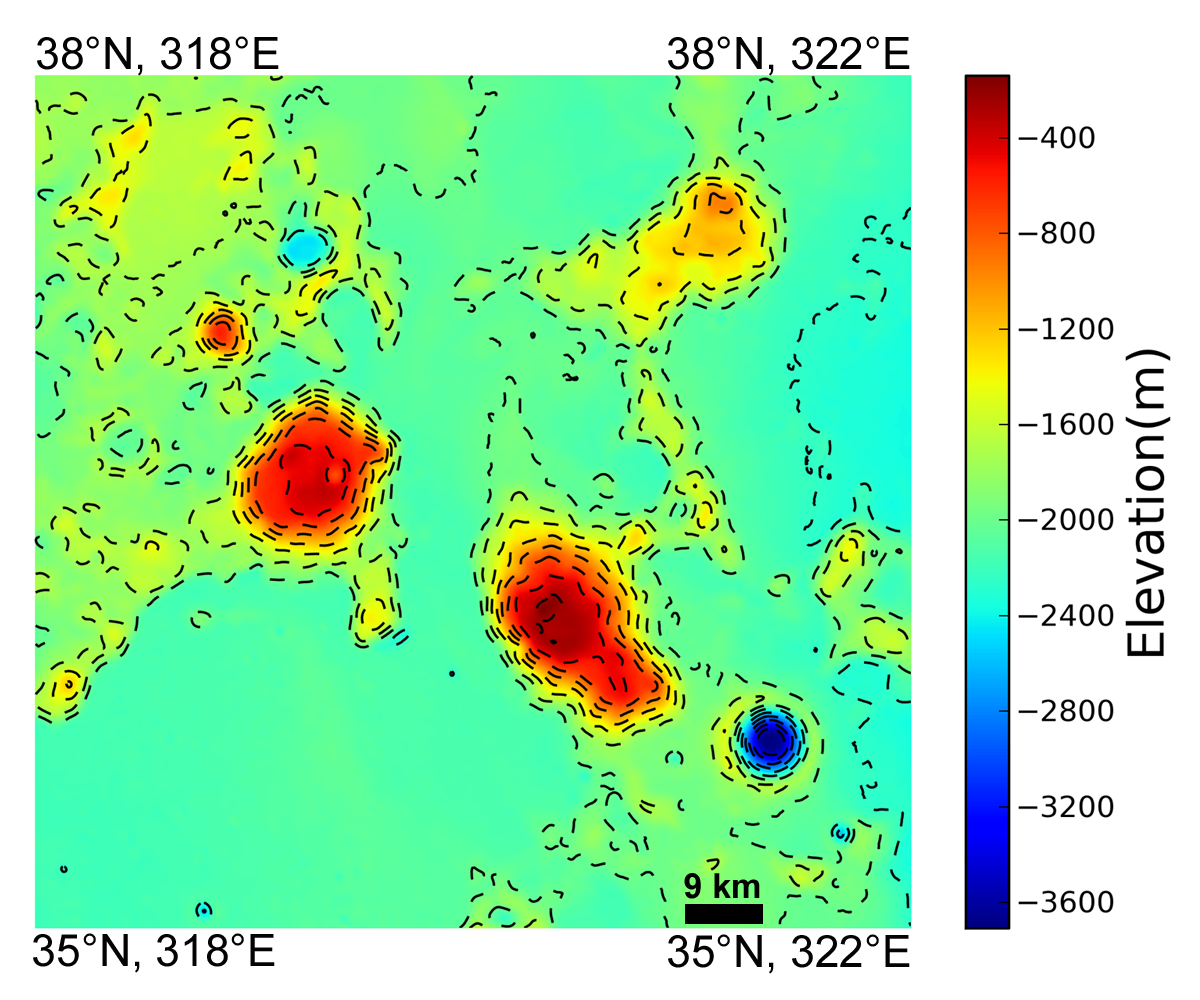 |
| Colorized topography of the Gruithuisen Domes region derived from the 100 m/pixel LROC WAC DTM. Contour line interval is 220 meters [NASA/GSFC/Arizona State University]. |
Related LROC Featured Images:
Gruithuisen Domes - Constellation Region of Interest
Morphology of lunar volcanic domes
LROC NAC DTM Viewer Gruithuisen Domes (ROI) 1 - 2 - 3 - 4 - 5
Hansteen alpha yields some of its secrets
Silicic volcanism on the Moon
Compton Belkovich - Constellation ROI
Hortensius Domes - Constellation ROI
Tuesday, June 12, 2012
LROC: Inside Rima Hyginus
 |
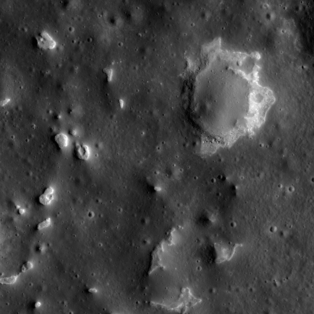
| Collapse features within Hyginus Crater. 1240 meter-wide field of view from LROC Narrow Angle Camera (NAC) observation M104476560L, LRO orbit 556, August 9, 2009; resolution 1.24 meters from 122.77 kilometers. View the LROC Featured Image, released June 12, 2012 HERE [NASA/GSFC/Arizona State Univeristy]. |

LROC News System
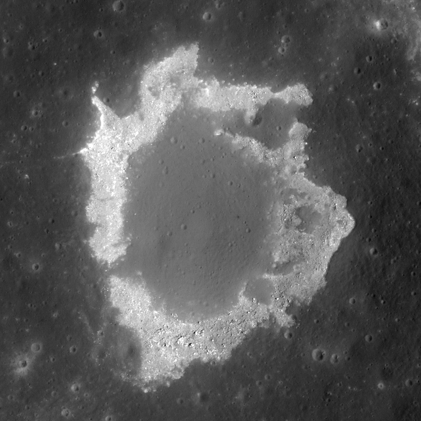
Most craters posted to the LROC Featured Image page are impact craters, however, Hyginus Crater (located at 7.75°N, 6.27°E, in Sinus Medii) is a volcanic crater known as a caldera. Two main pieces of evidence suggest that Hyginus Crater formed through volcanic processes. First, Hyginus lacks a raised rim typical of impact craters. Second, the rim of Hyginus is irregular (not circular), which is typical for volcanic craters caused by collapse. Also, if you look closely with the LROC NAC, the interior of Hyginus has a number of small irregular depressions which are most likely collapse features, indicating a volcanic origin for Hyginus. These irregular depressions are in the Featured Image, distinguished by rough, high reflectance material around their edges.
 |
| Eight meter per pixel resolution view from LROC QuickMap shows the "meniscus hollows" features in context with the eastern interior of Hyginus [NASA/GSFC/Arizona State University]. |
 |
| An almost oblique view (spacecraft and camera slewed 19.57° east from nadir), LROC WAC view from 42.29 kilometers over an area west of Rima Hyginus. The caldera, particularly its east walls, can be seen here in some relief, without the high angle of incidence seen in the next image. LROC WAC observation M165814883C (604nm), LRO orbit 9570, July 20, 2011; native resolution 62.94 meters [NASA/GSFC/Arizona State University]. |
 |
| LROC Wide Angle Camera (WAC) monochrome (689nm) observation of the Hyginus region. The yellow arrow marks the location of the collapse feature, the meniscus hollow, within Hyginus caldera seen at high resolution in the LROC Featured Image and the white arrow designates a small dome feature brought to attention by Maurice Collins. LROC WAC M117447052ME, orbit 2442, January 6, 2010; incidence angle 81.75° and a 62.6 meter resolution from 41.63 kilometers [NASA/GSFC/Arizona State University]. |


 |
| LROC NAC image M126887222L gives another look at the largest collapse feature in the main image. This image field of view is 487 meters wide (588 meters in the LROC Featured Image release), and has a lower illumination incidence angle, which emphasizes albedo differences over the kind of relief visible in the LROC WAC image immediately above. LRO orbit 3833, April 26, 2010; incidence angle 28.28° with a resolution of 0.48 meters from 40.55 kilometers [NASA/GSFC/Arizona State University]. |
Related Posts:
LPOD: Another Ina?
It's a gas, man
Brayley G
Sinuous Chain of Depressions
It's the Moon's Fault
You can read more about the Hyginus region in the Icarus paper, "An igneous origin for Rima Hyginus and Hyginus crater on the Moon."
Brayley G
Sinuous Chain of Depressions
It's the Moon's Fault
You can read more about the Hyginus region in the Icarus paper, "An igneous origin for Rima Hyginus and Hyginus crater on the Moon."
 |
| The central and western Hyginus and Rima Hyginus region and points immediately north and beyond under mid-morning illumination, as seen from around 100 kilometers over the south , a forward-looking HDTV still captured by Japan's lunar orbiter SELENE-1 (Kaguya) in 2008 [JAXA/NHK/SELENE]. |
Saturday, February 11, 2012
Support a startling and new 3D Moon map
 |
| Help "Kickstart" the wide distribution and availability of this excellent piece of work, a 3D map of the Moon that represents a substantial improvement over the famous (and incomplete) National Geographic lunar map first sent to Society members in March 1970. |
Lunar observers who devote much time online are already aware of the existence of a new anaglyph 3D Moon map because of the efforts of Dave Mosher for Wired via Charles A. Wood's essential "Lunar Picture of the Day."
As Chuck wrote very early February 11, "The Wired Science website just featured this stereo image of the Tycho ... region of the Moon.
"Jeffrey Ambroziak created the 3-D image from LRO digital terrain data by constructing red and blue anaglyph images from two slightly different perspectives. He and his father patented a new technique to create stereo images that work when viewed from nearly any angle or distance.
"As I have mentioned before, I can't see stereo so get out your red-blue glasses and send me your comments on how it works. Is it better than LRO anaglyph images by Maurice Collins and others?"
Echoing Dave Mosher's comments for Wired, this is a remarkable and very useful piece of work set up in such a way that everyone can both contribute and benefit.
View Dave Mosher's report on the Ambroziak 3D map HERE.
Subscribe to:
Posts (Atom)