Showing posts with label skylight. Show all posts

Sunday, January 25, 2015

On the beach with GLXP Team Hakuto

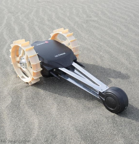
GLXP Team Hakuto lunar rover and backup under go deployment and rugged hazard and slope avoidance testing, on the beach in Hamamatsu  [Tim Stevens/c|net].
Tim Stevens

Before you blast off to the moon in search of $30 million offered as part of the Google Lunar X Prize -- or the juicy $20 million grand prize for being the first to get to the moon -- you must make sure all your systems are ready for the harsh realities that exist outside our atmosphere.

Testing in lunar-like conditions while still here on Earth is a complicated thing. Just finding a place remotely like the lunar surface is difficult. However, if you're in Japan, one place reigns supreme: the sand dunes outside Hamamatsu. This is where we found Team Hakuto, lone Japanese team competing for the GLXP, and one of five teams in the running for $6 million in interim, milestone prizes.

Many of Team Hakuto's members made the trip to Hamamatsu from Tohoku University, located far to the north in Sendai. While they escaped a blizzard, they arrived only to find winds well in excess of 30mph and temperatures hovering right around freezing. These were not ideal conditions for wandering up the beach -- nor for driving rovers across it.

Still, Team Hakuto went to work prepping not one, but two rovers: MoonRaker and Tetris. The first, the bigger of the two, is named not after the James Bond novel and movie of the same name, but rather some legendary English smugglers in the 18th century.

Hakuto's sub-rover Tetris, designed to explore the interior of one of the Moon's newly discovered mare pit craters [Tim Stevens / c|net].
According to the tale, on one clear evening two men were using rakes to scour the bottom of a lake in which some barrels of brandy had been hidden to avoid customs. Officers of the law wandered by and asked what they were up to, to which they replied they were attempting to rake some cheese in from the moon. The officers laughed and continued on their way, leaving the smugglers free to recover their stash of booze.

The mare pit crater in the Sea of Tranquility (8.337°N, 33.219°E) has been surveyed from LRO (by the LROC team that discovered it) at different angles and altitudes, enough to build an improving picture of its underground scope and potential as shelter from cosmic rays, micrometeors and the extreme temperature swings on the surface [NASA/GSFC/Arizona State University].
Team Hakuto, is in search of neither dairy products nor spirits, instead hoping to rake in $20 million for being the first commercial team to land on the moon and cover 500 meters while beaming back high-definition footage. However, the team also hopes to check out some lunar real estate, which is where the second rover, Tetris, comes in.

Read Tim Steven's full article HERE.
View his accompanying Hamamatsu gallery
HERE.
Catch up on extensive GLXP team coverage by c|net HERE.

Thursday, January 17, 2013

Channels and fractures at Anaxagoras

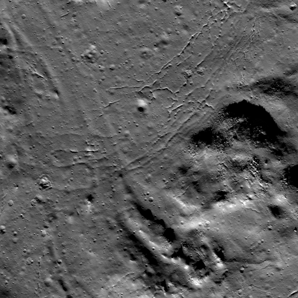
Stratigraphic relationships within impact melt deposits may be discovered with diligent observation. LROC Narrow Angle Camera (NAC) observation M185971152L, LRO orbit 12485, March 9, 2012, Field of view roughly 1.8 km, angle of incidence 73.05° at 1.75 meters resolution from 179.28 km [NASA/GSFC/Arizona State University].
Lillian Ostrach
LROC News System

Stratigraphic relationships in impact melt deposits are not always easy to find, but careful observations of the LROC NAC images provide the perfect opportunity to search! Yesterday's Featured Image presented overlapping distal margins of melt and "bathtub rings" on the northern wall of Anaxagoras crater. Today's Featured Image highlights another stratigraphic relationship in the southwestern portion of the melt pool in Anaxagoras (73.271°N, 349.033°E). Along with the typical fractures near the melt boundary interpreted to be the result of cooling and contraction, there is an impact melt-covered mound (opening image, right) with boulders eroding out from the steepest slopes. At the bottom of the image, there are two parallel troughs that cut through pre-existing material. These troughs probably represent impact melt-carved channels, where melt flowed from higher elevation to lower elevation and carved out a pathway.

But which way did the melt flow? Looking carefully, there are faint linear depressions extending from the top of the image to the channels, suggesting that flow progressed from the bottom right of the image toward the top left. These linear channels are very shallow, barely visible compared to the visible fractures. The shallowness of these channels possibly result from later movement of melt. The fractures cross-cut the shallow channels, indicating that the channels are older than the fractures.

LROC WAC monochrome mosaic of the rubbled interior of Anaxagoras crater (73.458°N, 349.934°E, - 52 km diameter). Location of the area shown at high resolution in the LROC Featured Image released January 17, 2013 noted by the yellow arrow [NASA/GSFC/Arizona State University].
However, note the sharpness of the fractures. The fractures that curve toward the mound and closest to the deeply carved channel troughs have a smoothed appearance when compared to the fractures closer to the top center of the image. Thus, there are two families of fractures, suggesting that perhaps the channels flowed into this area on top of a lightly-crusted pond (reasoning for shallow channels remaining) that then continued to cool, forming the first set of fractures. As the melt cooled more, maybe the second set of fractures formed if the second set is related to cooling.

Perhaps the second set of fractures formed as an internal plumbing system failed, or maybe an injection of hotter melt into this area (beyond the opening image frame) occurred that inflated the crust of the cooling melt and shallowed both the channels and first set of fractures. Without additional detailed observations, including NAC-derived topography, the stratigraphic story of melt movement and cooling concludes with at least two (three?) endings. However, the presence of small pits in the youngest fractures may provide supporting evidence for the plumbing or inflation story, because pits and fractures in the pond interior (away from the melt boundaries) are probably related to a lava tube-like underground melt plumbing system, a hypothesis supported by many NAC images at many different locations on the Moon.

What do you think? After studying the full LROC NAC image, HERE, do you have supporting evidence for the conclusion to the stratigraphic story of melt in this portion of Anaxagoras?

Related Posts:

Tuesday, January 24, 2012

Failed skylights of Copernicus

More than mere melt fracture, a narrow skylight among myriad melt fractures in the chaotic interior of the familiar nearside landmark Copernicus, at a resolution of 40 centimeters per pixel from 25.4 kilometers, August 18, 2011. LROC Narrow Angle Camera observation M168333206L; illumination from the southwest (bottom left) of directly overhead, angle of incidence 38.23° [NASA/GSFC/Arizona State University].
Joel Raupe
Lunar Pioneer

The LROC targeting team had already extensively mapped the interior of Copernicus before the brief period last August when the low point in the LRO polar orbit was reduced by half, sometimes below 25 kilometers. Copernicus might be the most photographed lunar crater after Tycho. Both of these relatively young impact craters are difficult to miss in any view of a waxing Moon seen from Earth. Both craters center on extensive and bright ray systems, and Tycho's being the youngest of the two can be picked out with the naked eye.

Copernicus, though larger than Tycho, seems less intense, almost smudged, and, indeed, it is more faded a more along in years, nearly old enough for the inevitable effects of space weathering to have gardened its face with optical maturity.

The interior, slumped terraced walls, rim and some of the ejecta blanket of Copernicus as seen in one of the very first LROC Wide Angle Camera (WAC) mosaics released by Arizona State University in early 2010. At its roughly 800 million year age Copernicus, namesake of the "revolutionary" polish astronomer Nicolas Copernic (1473-1543), has lent its name to the Copernican Age on the lunar timescale, that relatively recent and relatively sparse period of bombardment. Its interior is flatter in the north than at the south and features three central peaks. A bifurcated pattern to its rays system and topography has led some to speculate at least two progenitors of nearly equal size were involved in this impact event [NASA/GSFC/Arizona State University].
As LROC team member James Ashley was spotlighting the melt fractures of Jackson crater earlier this month we were already performing a survey of the same features on the floor of Copernicus, particularly within the crater's north-central and "more featureless" interior. The melt fractures within Copernicus seem more extensively gardened, and may have formed in a somewhat different way than those at Jackson. At Copernicus there seems to have been, or still may be, voids under the impact melt, and some evidence of what may be bubbling, places that seem to be half-submerged solid rubble on the floor of Tycho, for example, may be place where gases were trapped for a time, escaping after the impact melt had rapidly cooled and solidified.

The north central floor of Copernicus only seems less distinctive than the jumbled topography of its surroundings. Barely visible in this LROC WAC monochrome (643 nm) image is a web of fractures and channels throughout the most level terrain above. A 35 km-wide field of view from LROC WAC observation M147109260C, orbit 6813, December 16, 2010; resolution 60.3 meters per pixel at an incidence angle of 78° from 43.13 kilometers [NASA/GSFC/Arizona State University].
Both the north and south ends of this 42 meter-wide exposed fracture on the floor of Copernicus are nearly buried or are not quite as wide as this section. While its tempting to see the western side as an overhang, and despite the apparent differences in the opposing edges, the exposed rift is likely only slightly deeper and more shadowed. There is evidence enough for voids under the floor of Copernicus but the more obvious clues have been pulverized by space weathering and moon quakes since the crater's formation. LROC NAC observation M157730473L, orbit 8379, April 18, 2011; angle of incidence 24.32° on a field of view 270 meters wide at a resolution of 0.47 meters from 37.85 kilometers [NASA/GSFC/Arizona State University].
Is this 300 meter-wide feature on the floor of Copernicus a crater, a void shaken to collapse or a little of both? Apparent layering in rapidly cooling impact melt may be a result of differing arrival times of the melt. LROC NAC M168333260L [NASA/GSFC/Arizona State University]. 
The area of interest on the floor of Copernicus is distinguished by its melt fractures, many obvious and others mysterious. The traces of these fractures are often marked with pits, their openings too shadowed or narrow to measure - even discovering whether any are really open at all and what may lay below awaiting future exploration. Between the two "pits" appears to be a spot long collapsed - but what if anything actually collapsed? Also from LROC NAC M168333206L [NASA/GSFC/Arizona State University].
Zoom in, out and around this area of interest in Copernicus using the LROC QuickMap, HERE, in views like the one below.