

The Big Tease: Two high-resolution samples of the lunar surface in GoogleMoon™ represent interesting and widely varied near side terrain thought by too many as adequately understood. Exploring these areas in the program can seem like a child's first look at pond water under a microscope. Though you won't see anything swimming around, you can go for a swim in the data.
Joel Raupe
Lunar Pioneer
The largest of two high-resolution strips in GoogleMoon combines orbital metric photography from Apollo with laser altimeter data and Terrain Camera images from Japan's Kaguya and India's Chandrayaan-1 in a six degree-wide swath through ninety degrees of longitude - a quarter way around the Moon - from 25.2°N, 331.8°E (28.2°W) in Mare Imbrium on the West to 7.8°N, 60.8°E, near Lacus Persevertantiae southeast of Mare Crisium, on the East.
A smaller 160 kilometer-square part of the Southern Lunar Highlands surrounds the Apollo 16 landing site and includes the distinctive topography of the Descartes Formation and its albedo Swirl. Finally, in GoogleMoon™ are small swaths from early Lunar Reconnaissance Orbiter (LRO) imagery of each of the six Apollo landing sites.
High-resolution laser altimetry is not weaved into these LRO images of the landing sites of either Apollo 12 or Apollo 14, making those areas unsatisfactory and two-dimensional, like the largest part of the lunar globe disappointingly represented by Clementine (1994) baseline imagery with much far lower resolution altimetry, on the whole creating a wide-rolling flat worldwide enlarged and highly pixilated photograph.
The Apollo Metric Cameras were deployed from the Service Modules of Apollo 15, 16 & 17, Apollo's science (or "J") missions. These film canisters were retrieved in deep-space EVAs during the long coast back to Earth, after leaving lunar orbit.
GoogleMoon™ does not include the full range of this Apollo photography, particularly of the far side. While confined to the sun-lit surface under orbits keeping Command Modules over the landing sites, the full range of the surface photographed from orbit covered at least ten-fold more of the surface.
Kaguya and Chandrayaan-1 altimetry, if not their terrain cameras, covered the entire Moon.
Hopefully GoogleMoon™ developers await data gathered by LRO and a future roll-out of GoogleEarth™ (v.6) for a more complete coverage of the rest of Moon. Putting together what they have must have been a lot of work.
The high-resolution that is available in GoogleMoon™ is represents thousands of square kilometers of detail in context, allowing a human perspective of what would otherwise simply be a flat-file of numbers.
Devoted lunatics are now allowed an opportunity to "see it like a native," and to classify some newly-resolved features invisible using the best telescopes on Earth.

This is the largest example of what evidence indicates is a common feature in certain locations on the Moon.
The collis 'Cathedral Rock' is apparently one in a family, sharing distinctive characteristics. In the picture immediately above, like Medieval siege engines rolled to the edge of a city wall, 'Cathedral' stands not far from two smaller family members, off in the distance. The view is from a perspective slightly above the basin floor aimed to the southeast, along a small part of the massive Crisium rim.
We're very unofficially calling this family of colles the "colles arduum," because of the arduous work needed to get to their top. These seem to be a common sight where the basin's lava-flooded interior basin butts up against its inner ring. Crisium formed through a cataclysmic impact 3.92 billion years ago, but aside from globe-shaking moonquakes that have occurred throughout that long period, bringing material down in repeated slumps from the heights beyond, this family of colles have looked much as they do today during all that time.
On Earth such formations would immediately be guessed to be the result of wind and water erosion but these colles are made of some pretty tough stuff, perhaps at its hardest along the length of its spire.
These features are dark, when found in the Apollo images, as well, indicating a very long period of optical maturity and at least 900 million years of exposure to the sun.
Perhaps the colles are fumaroles, formally within the crust that was blown away from the center of the Crisium impact 200 kilometers away. We note that the colles seem common along this basin wall but we have also found similar collis deep within basin's interiors.
The base of collis "Cathedral Rock" (10.81°N, 54.32°E) is around a kilometer across and irregularly shaped. Like other members of its family there is also is is a secondary ridge on top of this, running length-wise. And from the end of the secondary ridge that is furthest away from the Crisium ring behind it is the landmark spire rising almost to a point.
The inner ring of mountains surrounding Crisium seen behind the tower rises another kilometer and a half above the basin to the left, itself around 3,500 meters below the Moon's mean elevation. The top of the Cathedral's spire is 1,500 meters above the basin. Further along to the east-southeast the basin's steep wall reaches above 500 meters, adding up to a difference in elevation of at least a 4 kilometers within a two to three kilometers walk.
And this is pretty average and not record-breaking for the Moon or Crisium.
We decided to verify Cathedral Rock because we wanted to investigate the usefulness of GoogleMoon, as a legitimate tool of exploration.
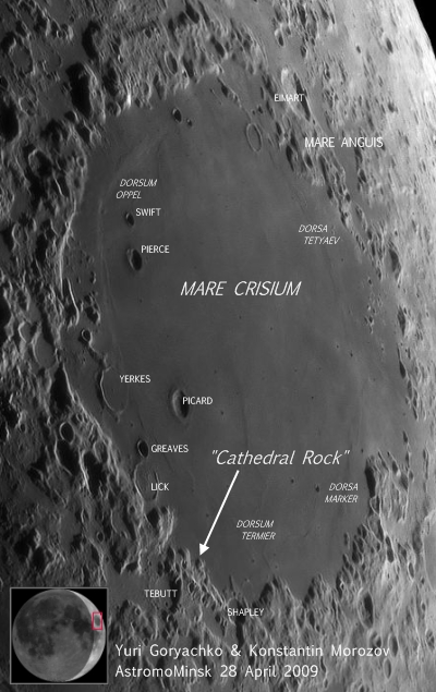
In a preliminary search through the best lunar photography taken from Earth we began with the many excellent images of Crisium contributed by scientist-artists to Charles A. Wood's Lunar Picture of the Day.
In the end we chose a mosaic referenced there and composed from 9 images of a Crescent Moon last April, assembled by Yuri Goryachko & Konstanin Morozov.
The image immediately above was ripped from that mosaic.
The tip of the arrow designates an apparently empty spot near a tiny peninsula, meandering north (top) 15 kilometers or so into Crisium from its surrounding inner ring. It is the precise spot where we found Cathedral, and the face of the range immediately behind it in the second image from the top of this article is part of the small peninsula above. It looks very small 400,000 kilometers away, but the tip of the arrow points at what looks like more basin floor.
Is it real?

It's important to know if Cathedral Rock is really there.
If it is a powerful tool for lunar exploration has been made available to a very large group of devotees.
GoogleMoon™ can't be a substitute for other tools of exploration and analysis, but it may present a powerful answer to a problem recently posed by Apollo veteran and geologist Dr. Harrison H. "Jack" Schmitt. He has noted a big problem presents itself in the sheer size of the data collected by a the small, but very sophisticated fleet of 21st century probes; China's Chang'e-1, Japan's Kaguya, India's Chandrayaan-1 and the Lunar Reconnaissance Orbiter from the United States. The depth of these data presents scientists with a formidable analytic and cataloging nightmare.
Ten years after Lunar Prospector de-orbited into Shoemaker Crater, near the lunar south pole, scientists still work and tweak data that the $60 million orbiter returned, and they are still discovering new things. Chandrayaan and Kaguya returned datasets that dwarf what was returned from earlier missions, and nearly as much information has already been returned from LRO after barely more than 110 days into its mission.
Is one solution to the problem of slow assimilation and analysis of these data standing right in front of our eyes?
Years into the Age of Video Games, with virtual worlds made three-dimensional with ray-trace animation, it's prudent to examine whether a feature like Cathedral Rock is just repeated landscape, like virtual trees repeated over and over in a Flight Simulator landscapes, patterns within an otherwise realistic landscapes that are just 'filler.' There are other families of colles that share strikingly suspicious similarities elsewhere in the high-resolution corridor in GoogleMoon™, and we will discuss these in Part 3.

2 comments:
I'm sorry, but this feature is just a bad data point in the DEM. Anything that dramatic in topography would show up with a distint shadow in Lunar Orbiter images with lower sun than those you examined. But it's not there.
Your comments about limitations in the Google lunar map are quite correct, but this is just an early version. Incidentally, check out the spectacular Tycho details from Kaguya. When the Kaguya data are released in about November you can expect to see plenty of additions to this - but remember they will take time. All this lunar material in Google is basically the work of one person and it all takes a lot of time and effort.
Phil
Thank you for weighing in, Phil.
It's good to hear from you, and I appreciated you comments.
I remain skeptical of this formation's existence, too, for a variety of reasons I hope to touch upon in the next, hopefully final, installment.
Time ran out for touching upon proper, even cursory, examination of Lunar Orbiter photography, specifically IV-054-H2 from 2736 km (f=64.5°) & IV-191-H3 from 5503 km (f=73.7°). The narrative also requires a better discussion of the Apollo Metric photography and how the choice of landing sites for the J missions affected lighting over Crisium.
Adding Tycho to the mix will be a very welcome addition, indeed.
I downloaded the Kaguya tour of Tycho within a few hours of its release & JAXA, getting a welcome head-up from Charles Wood. Displaying it has been a method for taking breath away from people wondering about my interest in the Moon.
As to the one person involved in this Herculean Effort, "a lot of time and effort," would that person be yourself?
Again, it was great to hear from you. My partners and I welcome your comments anytime.
- Joel Raupe
Post a Comment