Showing posts with label Humboldtianum. Show all posts

Wednesday, February 19, 2014

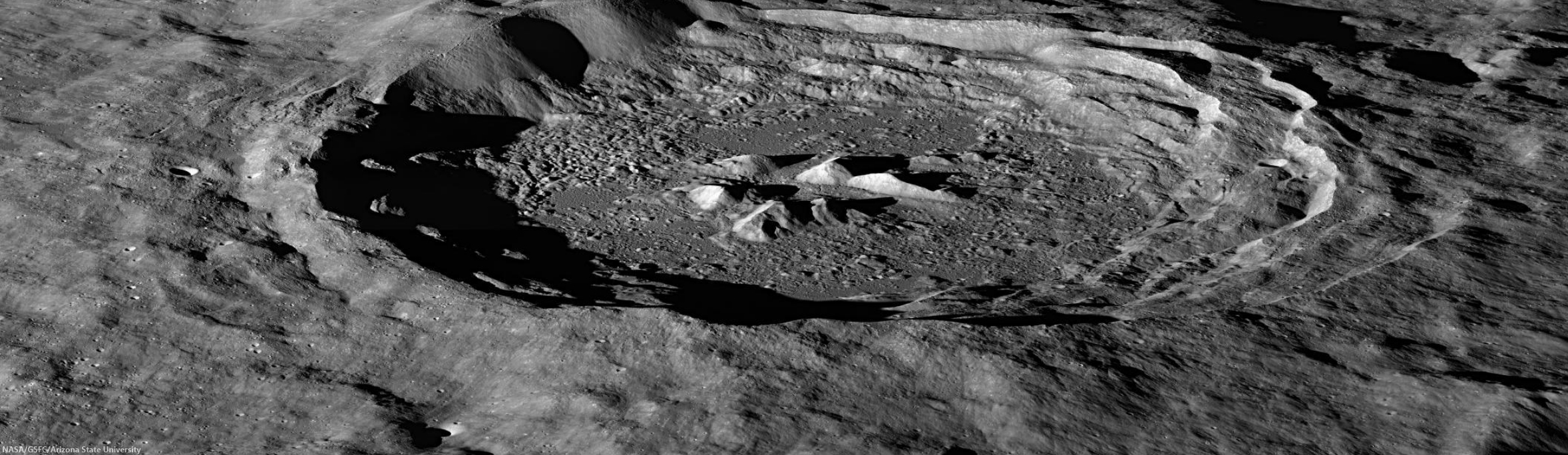
Oblique view of Hayn crater

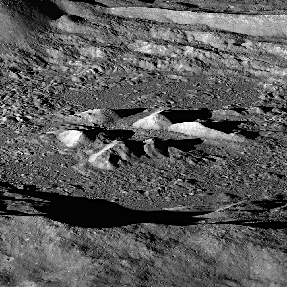
Central peaks of Hayn crater (LROC NAC oblique)
Central peaks of Hayn crater, rising 1.5 km above the crater floor. Image is approximately 32 km across. LROC Narrow Angle Camera oblique mosaic M1105158497LR, orbit 15170, October 18, 2012; incidence angle 78.44° at a roughly estimated resolution of 4.7 meters per pixel. Spacecraft and camera slewed 57.46° east from nadir, 179.93 km over 68.01°N, 111.56°E [NASA/GSFC/Arizona State University].
H. Meyer
LROC News System

Hayn Crater (86.2 km, 64.55°N, 83.87°E) located just northeast of Mare Humboldtianum, is an exquisite example of a complex crater.

The central peak complex in the image above is dramatically illuminated by the low Sun casting long shadows across the crater floor.

The floor of Hayn crater contains spectacular remnants of the impact event: impact melt, slump blocks, and complex debris. In some areas, rocks on the floor have cracked and eroded into fields of boulders.
Oblique view of Hayn crater (LROC NAC)
A reduced resolution version of the full NAC oblique of Hayn crater (64.58°N, 83.89°E). Hayn is approximately 86 km in diameter. North at right; LROC Narrow Angle Camera oblique mosaic M1105158497LR, orbit 15170, October 18, 2012; incidence angle 78.44° at a roughly estimated resolution of 4.7 meters per pixel. Spacecraft and camera slewed 57.46° west of nadir, from 179.93 km over 68.01°N, 111.56°E [NASA/GSFC/Arizona State university].
In the full oblique image above, the walls of Hayn display large terraces that formed in the final stage of crater formation, called the modification stage. They are the surface expression of concentric listric faults.

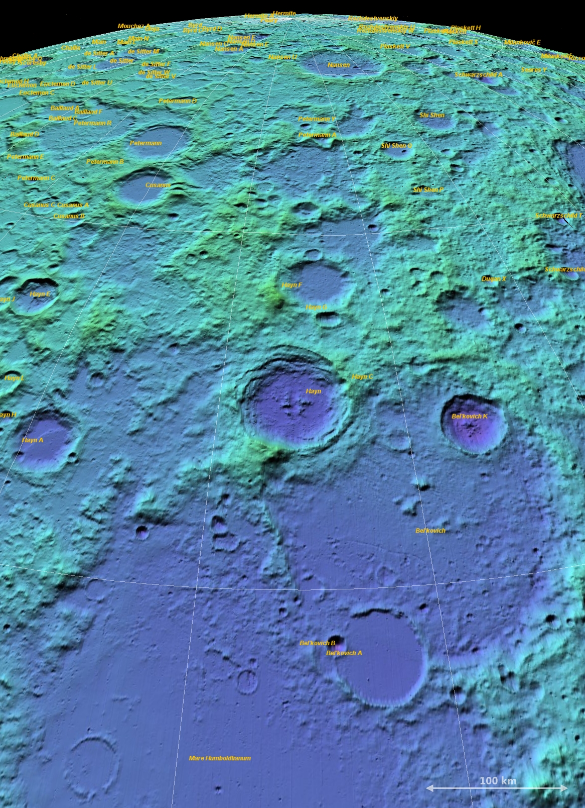
Hayn-Humboldtanium basin (LOLA ILIADS)
Another, perhaps superfluous though certainly extraordinary, contexual view of Hayn with its emphasis on the crater's proximity with the Moon's north pole. LRO LOLA false color laser altimetry, at 128 points per pixel, through NASA's ILIADS application, a false perspective from 447 km over 55.3189°N, 78.7145°E, a point measured 4.127 km below mean global elevation (The image can be seen at its full size by clicking on it or HERE.) [NASA/GSFC/MSFC].
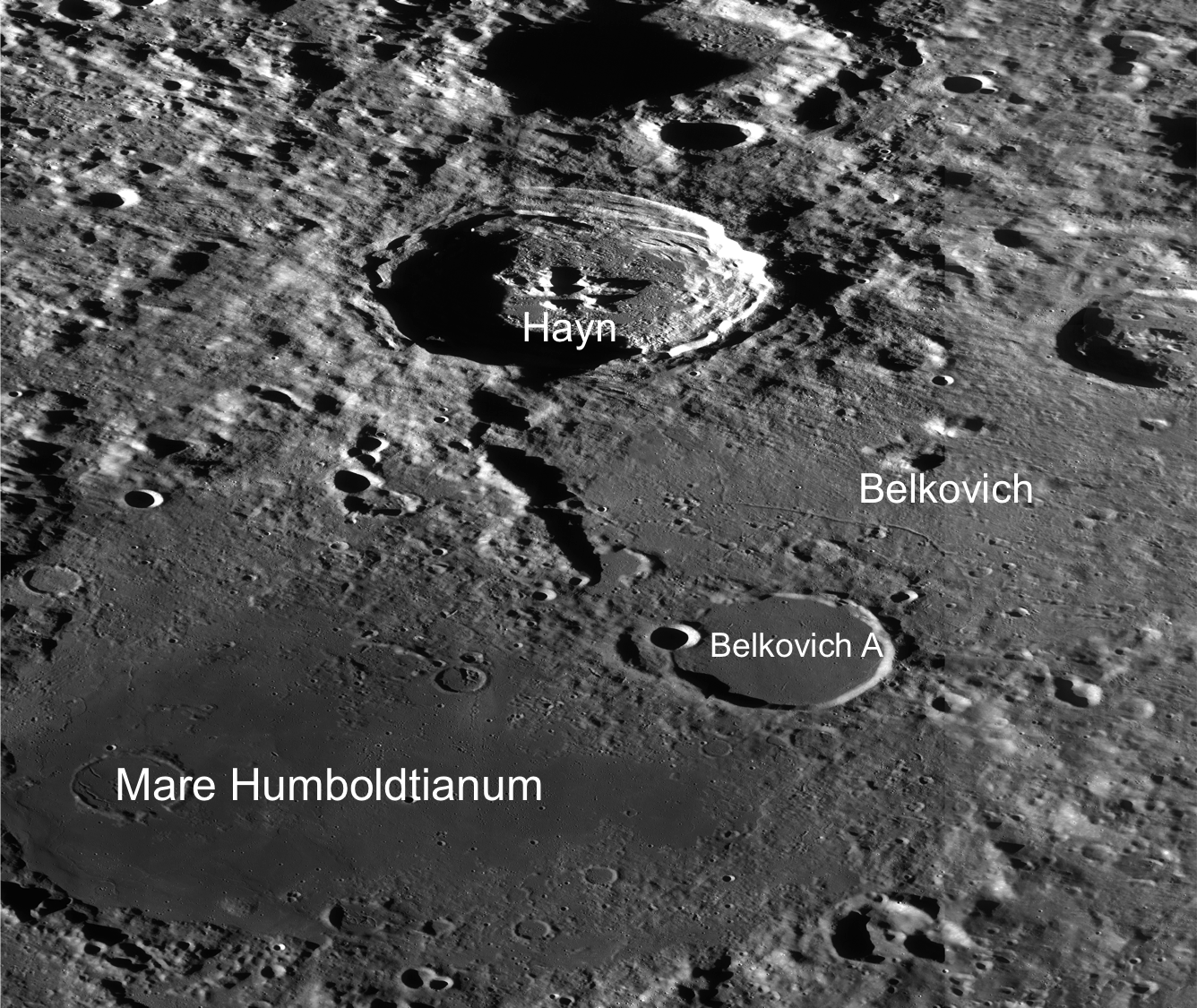
Hayn and Humboldtianum (LROC WAC)
LRO WAC image for context. Orthographic projection, field of view is approximately 220 km across [NASA/GSFC/Arizona State University].
These faults develop as the transient cavity undergoes gravitational collapse. The formation of terraces widens the crater cavity and shallows out the floor. This downward movement of the walls and floor is followed by uplift in the center as the crust accommodates the stress of the impact.


LROC Wide Angle Camera-derived digital terrain model showing Hayn is hemispheric context, orthographic projection centered on 60° East. Illustration to earlier LROC post "Craggy Peak, Impact Melts," January 12, 2012 [NASA/GSFC/Arizona State University].
Enjoy the exquisite full-resolution NAC oblique, HERE.

Related LROC Posts:
Craggy Peak, Impact Melts
Melt or Rubble?
View from the Other Side

Thursday, January 12, 2012

LROC: Craggy Peak, Impact Melts

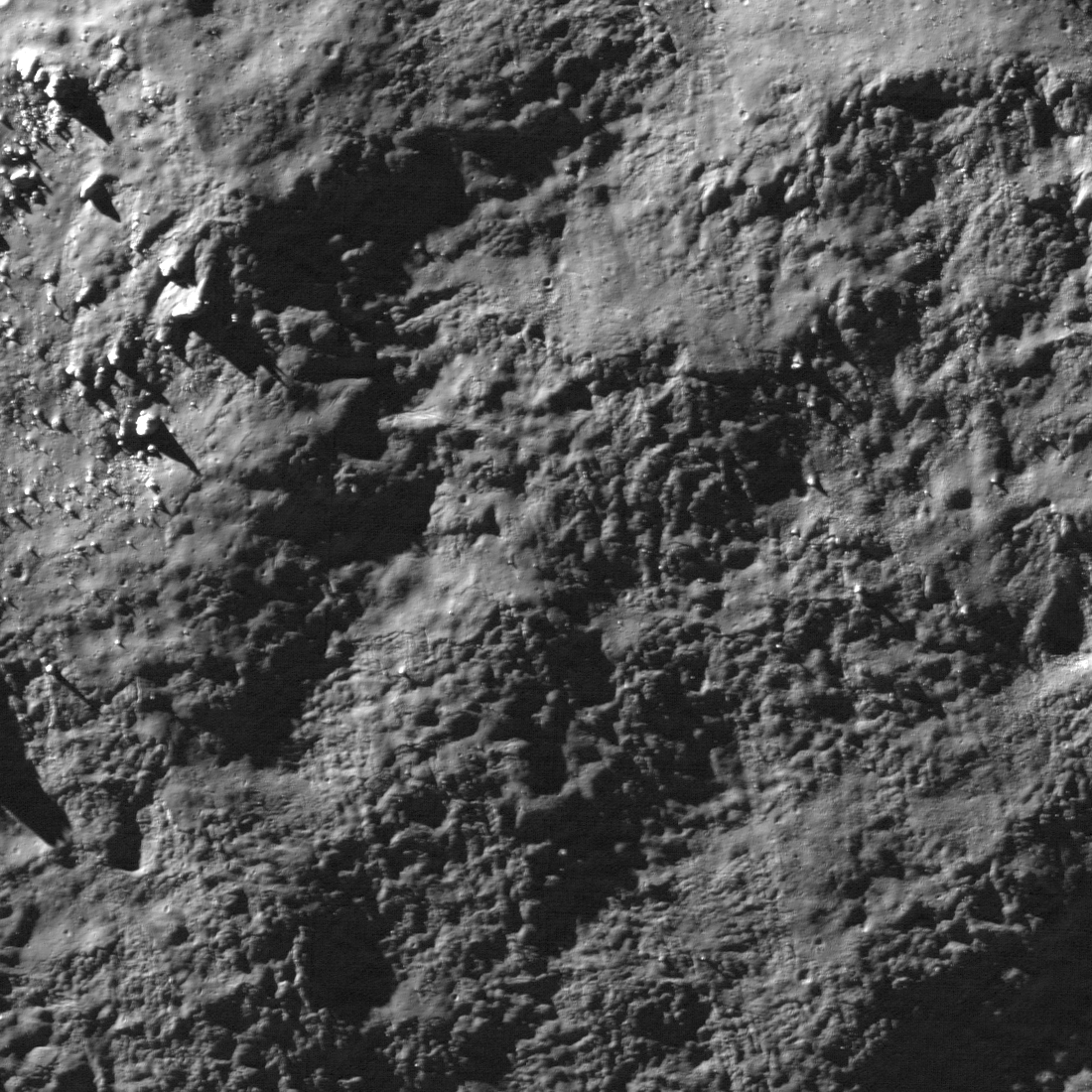
Northern slope of one of four central peaks in Hayn crater, on the northern edge of Humboldtianum basin. Downslope direction is from top to bottom (North is down), image field of view is 594 meters, sunlight is from upper left. LROC NAC observation M128754462L, orbit 4108, resolution 0.54 meters from 51.78 kilometers. View the full size LROC Featured Image HERE [NASA/GSFC/Arizona State University].
Hiroyuki Sato
LROC News System

Due to the tremendous energy released by an impact event large portions of the target rock is melted. This impact melt forms distinctive flows and ponds both inside and outside of its parent crater. In many young craters the LROC NAC has captured deposits that look as if they formed yesterday.

Today's Featured Image is on the northern slope of the Hayn crater central peak. Due to the peak's steepness, it is rough and craggy. In many places on the peak wavy deposits are seen between crags and blocks; these deposits are most likely impact melt. Truly amazing, first the central peak formed then impact melt splashed down and coated it. If this interpretation is correct you can say that the peak formed in matter of a few seconds, quickly enough that melt that was thrown during the impact had not yet landed!  Quantitative measurements of these kind of spectacular outcrops, using new accurate topography from LROC NAC stereo will help reveal how impact craters form.

LROC QuickMap WAC monochrome 125 meter per pixel projection of Hayn and vicinty, centered at 64.34°N, 83.94°E. The yellow arrow indicates the locations of LROC Featured Image field of view [NASA/GSFC/Arizona State University].
Hayn is an exceptionally deep crater because it is situated just within the northern mountainous ring of 550 km-wide Humboldtianum basin, which extends far beyond its deep interior Mare Humboldtianum. The entire basin straddles the 90° east meridian, though Mare Humboldtianum is a nearside basin visible at favorable lunar librations. The floor of Hayn is 4.9 kilometers below global mean elevation and it's northern crater rim is still more than a half kilometer below global mean. The mountain directly north of Hayn, a worn remnant of the Humboldtianum basin rim is 2.3 kilometers above global mean, nearly a seven thousand meter change in elevation over the eighty kilometers between that massif and the center of Hayn. LROC Wide Angle Camera (WAC) 100 meter per pixel digital terrain model, color shaded relief, orthographic projection centered on 60° east [NASA/GSFC/Arizona State University].

Explore the craggy peak and impact melt deposits, both on the peak and the floor of Hayn crater, HERE.

Related Posts:
On the floor of Green M
Splash and flow
Ejecta in Tycho crater
Natural Bridge on the Moon!

Friday, June 4, 2010

Humboldtianum two for one from LRO


Rectangular sampling of LRO Narrow-Angle Camera frame M119354856R, including the area at upper left center brought forward as LROC News System's Featured Image, June 4, 2010. "Small crater and associated boulders near the center of the Constellation Region of Interest in Mare Humboldtianum," straddling the boundary between the mare of the inner basin and the lunar highlands. "Note the different textures of the highlands (bottom) and mare basalts (top). Explorers at this location will obtain key information about the lunar geologic timescale. Area shown in the image above is approximately 1 km wide; LRO orbit 2723, January 28, 2010, resolution = 0.52 m/pixel [NASA/GSFC/Arizona State University].

Bashar Rizk
LROC News System

Mare Humboldtianum is an ancient impact basin on the northeast limb of the Moon whose inner ring was flooded by basalt billions of years ago to form the mare. The Constellation region of interest in Humboldtianum is located in the southwest portion of the mare, straddling the mare highlands boundary.

In LROC's Featured Image, June 4, 2010, we see the center of the Constellation Region of Interest, where the mare basalts meet the highlands. The highlands are characterized by their high reflectance and the distinctive, so-called "elephant skin" texture, while the mare basalts are characterized by their low-reflectance, relatively smoother surfaces.


LROC Wide Angle Camera context image showing the approximate location of LROC's Featured Image in Mare Humboldtianum. The image at the top of this post is approximately within the smaller (yellow) rectangle, nested, in turn, inside the full-swath of NAC frame M119354856R NAC frame, superimposed on the WAC mosaic above. The 57 km-wide WAC image is represented by a white rectangle drawn upon the LOLA false-color elevation model of Humboldtianum, below [NASA/GSFC/Arizona State University].

Since (Humboldtianum ROI) is at the edge of a large impact basin, based on the Apollo experience it is likely that you can find samples of the basin melt sheet here. During large, basin-forming impact events, the shock of the impact disaggregates rocks in the impact zone, and these smaller fragments are swept up in the sheet of impact melt that sweeps outward from the point of impact. Consequently, the solidified impact melts contain fragments of the rocks and minerals that were present in the crust at the point of impact. Lunar scientists can therefore study these impact melts, billions of years after the impact, to unravel fundamental geochemical information about the composition and heterogeneity of the lunar crust.

For example, how would the basin impact melts we collect in Humboldtianum differ from those collected at the landing sites of Apollo 15, 16, and 17?

We can't answer that important question until human explorers do the necessary fieldwork at this site. Also importantly, the highlands and mare samples collected from this location would be radiometrically age-dated, providing key information about when the basin formed and when it filled with the erupting mare basalts--important questions for helping to clarify the lunar geologic time scale.

The Humboldtianum site offers several operational benefits. As a near-side location it would give astronaut explorers the chance to survey a unique, high-latitude location while remaining in Earth's line of sight, which is important for communications. The mare regolith at this site would also provide easy access to feedstock for in-situ resource utilization (ISRU), while still enabling access to the lunar highlands.


For more information on LROC's observation campaign for the Constellation program regions of interest read this Lunar and Planetary Science Conference abstract, and visit the LRO Science Targeting Meeting website (look for the baseball card summary sheets for each site: part 1, part 2).


Like a box within a box, or a Russian nested doll, a portion of the LRO Lunar Orbiter Laser Altimeter (LOLA) "Image of the Week," also focused on Mare Humboldtianum on June 4, lending further context to the LROC WAC frame above, represented by the 57 km-wide area within the white rectangle [NASA/GSFC].

GSFC/LOLA - Located along the northeastern limb of the Moon (centered at approximately 56.8°N, 81.5°E), Humboldtianum Basin is a (Second Tier) Constellation program Region of Interest. LOLA data show the 650 km diameter basin is more than 4.5 km deep. The impact that formed Humboldtianum is estimated to have happened during the Moon's Nectarian Period, approximately 3.92-3.85 billion years ago.

Many other multi-ring impact basins are also believed to have formed during this time period, including Crisium.

In the inner ring of Humboldtianum Basin is Mare Humboldtianum (Humboldt's Sea). LOLA data reveal the relatively smooth, flat floor of the mare. The younger mare is believed to have formed during the Late Imbrian, approximately 3.8-3.6 billion years ago.

Also visible in the basin are smaller craters that were partially filled in by the mare lava. Humboldtianum was named after explorer Alexander von Humboldt (1769-1859) and is one of only two lunar seas named after people, the other being Smythii named for British astronomer William Henry Smyth (1788-1865).

* The LRO team at Goddard Space Flight Center shines as we approach the unbelievable 1st Anniversary of the launch of LRO, together with LCROSS, June 18, 2009, - by presenting an outstanding "two-for-one." The result speaks for itself.

LOLA Image of the Week, simultaneous with the most recent LROC Featured Image from Arizona State University, was released Friday, June 4, 2010.